開啟輔助訪問
 找回密碼
 立即加入

22S.Marian 曾短暫增強至澳式C4 逐漸南下減弱

簽到天數: 1650 天

[LV.Master]伴壇終老

老農民版夜神月|2021-3-3 09:15 | 顯示全部樓層
本帖最後由 老農民版夜神月 於 2021-3-3 16:15 編輯

JTWC00Z降格C1
22S MARIAN 210303 0000 18.9S 90.9E SHEM 80 969

20210303.0040.himawari-8.ir.22S.MARIAN.80kts.963mb.18.9S.90.9E.100pc.jpg 20210303.0040.himawari-8.vis.22S.MARIAN.80kts.963mb.18.9S.90.9E.100pc.jpg 20210302.2146.f18.91pct91h91v.22S.MARIAN.85kts.968mb.18.7S.90.5E.055pc.jpg
avn_lalo-animated (4).gif
回復

使用道具 舉報

簽到天數: 1650 天

[LV.Master]伴壇終老

老農民版夜神月|2021-3-3 16:21 | 顯示全部樓層
06Z再大舉下調定強至C1下限65節,即將減弱為TS
22S MARIAN 210303 0600 19.1S 91.4E SHEM 65 975
20210303.0750.himawari-8.vis.22S.MARIAN.65kts.975mb.19.1S.91.4E.100pc.jpg LATEST - 2021-03-03T161832.263.jpg ir_lalo-animated (15).gif
回復

使用道具 舉報

簽到天數: 483 天

[LV.9]以壇為家II

dom|2021-3-3 21:02 | 顯示全部樓層
JTWC12Z降格TS,BoM定強澳式C2下限
22S MARIAN 210303 1200 19.3S 92.1E SHEM 50 985
TPXS10 PGTW 031228

A. TROPICAL CYCLONE 22S (MARIAN)

B. 03/1145Z

C. 18.93S

D. 92.18E

E. FIVE/GOES-IO

F. T3.0/3.5/W1.5/24HRS STT: S0.0/03HRS

G. IR/EIR

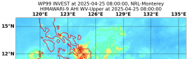
H. REMARKS: 38A/PBO SBC/ANMTN. CNVCTN WRAPS 0.5 ON LOG10 SPIRAL
YIELDING A DT OF 2.5.. MET AND PT YIELD 3.0. DBO PT.

I. ADDITIONAL POSITIONS: NONE


HEINS
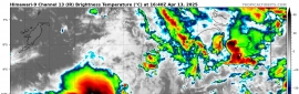
At 1200 UTC Tropical Cyclone Marian was centred within 30 nautical miles of
latitude nineteen decimal one south (19.1S)
longitude ninety two decimal zero east (92.0E)
Recent movement : east southeast at 6 knots
Maximum winds : 50 knots
Central pressure: 983 hPa
fcd0c9177f3e6709305023b42cc79f3df9dc55fb.jpg
Time (AWST)Intensity CategoryLatitude
(decimal deg.)
Longitude
(decimal deg.)
Estimated Position
Accuracy (km)
0hr8 pm March 3219.1S92.0E55
+6hr2 am March 4219.6S92.5E80
+12hr8 am March 4220.1S93.1E90
+18hr2 pm March 4220.7S93.5E95
+24hr8 pm March 4221.3S94.0E100
+36hr8 am March 5122.8S94.7E110
+48hr8 pm March 5124.2S95.4E150
+60hr8 am March 6tropical low25.6S95.7E195
+72hr8 pm March 6tropical low26.6S96.2E270
回復

使用道具 舉報

簽到天數: 1650 天

[LV.Master]伴壇終老

老農民版夜神月|2021-3-4 02:13 | 顯示全部樓層
本帖最後由 老農民版夜神月 於 2021-3-4 11:12 編輯

BoM在報文中認為強度將持續暫時的固定在50節大約一天,随後回到減弱的大趨勢並消亡
IDW27600
TROPICAL CYCLONE TECHNICAL BULLETIN: AUSTRALIA - WESTERN REGION
Issued by AUSTRALIAN BUREAU OF METEOROLOGY TROPICAL CYCLONE WARNING CENTRE
at: 1804 UTC 03/03/2021
Name: Tropical Cyclone Marian
Identifier: 15U
Data At: 1800 UTC
Latitude: 19.7S
Longitude: 92.8E
Location Accuracy: within 30 nm [55 km]
Movement Towards: east southeast [119 deg]
Speed of Movement: 8 knots [15 km/h]
Maximum 10-Minute Wind: 50 knots [95 km/h]
Maximum 3-Second Wind Gust: 70 knots [130 km/h]
Central Pressure: 984 hPa
Radius of 34-knot winds NE quadrant: 130 nm [240 km]
Radius of 34-knot winds SE quadrant: 160 nm [295 km]
Radius of 34-knot winds SW quadrant: 150 nm [280 km]
Radius of 34-knot winds NW quadrant: 130 nm [240 km]
Radius of 48-knot winds NE quadrant: 70 nm [130 km]
Radius of 48-knot winds SE quadrant: 70 nm [130 km]
Radius of 48-knot winds SW quadrant: 70 nm [130 km]
Radius of 48-knot winds NW quadrant: 70 nm [130 km]
Radius of 64-knot winds:
Radius of Maximum Winds: 30 nm [55 km]
Dvorak Intensity Code: T3.5/3.5/W1.0/24HRS STT:S0.0/6HRS
Pressure of outermost isobar: 1004 hPa
Radius of outermost closed isobar: 300 nm [555 km]
FORECAST DATA
Date/Time    : Location    : Loc. Accuracy: Max Wind   : Central Pressure
[UTC]        : degrees     :      nm  [km]: knots[km/h]: hPa
+06:  04/0000: 20.2S  93.6E:     045 [080]:  050  [095]:  984
+12:  04/0600: 20.7S  94.0E:     050 [090]:  050  [095]:  984
+18:  04/1200: 21.4S  94.5E:     050 [095]:  050  [095]:  984
+24:  04/1800: 22.1S  94.9E:     055 [100]:  045  [085]:  986
+36:  05/0600: 23.5S  95.6E:     060 [110]:  040  [075]:  989
+48:  05/1800: 24.9S  96.1E:     080 [150]:  035  [065]:  993
+60:  06/0600: 26.2S  96.5E:     105 [195]:  035  [065]:  992
+72:  06/1800: 26.9S  96.7E:     145 [270]:  035  [065]:  991
+96:  07/1800: 28.6S  96.4E:     235 [435]:  030  [055]:  995
+120: 08/1800: 30.8S  95.9E:     310 [570]:  030  [055]:  993

IDW60280 (15).png 20210303.1740.himawari-8.ir.22S.MARIAN.50kts.985mb.19.3S.92.1E.100pc.jpg
20210303.1245.f17.91pct91h91v.22S.MARIAN.50kts.985mb.19.3S.92.1E.095pc.jpg
回復

使用道具 舉報

簽到天數: 1650 天

[LV.Master]伴壇終老

老農民版夜神月|2021-3-4 09:45 | 顯示全部樓層
本帖最後由 老農民版夜神月 於 2021-3-4 11:13 編輯

顯然22S並未如預報暫時停止減弱的步伐
BoM00Z降澳式C1
IDW27600
TROPICAL CYCLONE TECHNICAL BULLETIN: AUSTRALIA - WESTERN REGION
Issued by AUSTRALIAN BUREAU OF METEOROLOGY TROPICAL CYCLONE WARNING CENTRE
at: 0137 UTC 04/03/2021
Name: Tropical Cyclone Marian
Identifier: 15U
Data At: 0000 UTC
Latitude: 20.6S
Longitude: 93.2E
Location Accuracy: within 25 nm [45 km]
Movement Towards: southeast [143 deg]
Speed of Movement: 9 knots [17 km/h]
Maximum 10-Minute Wind: 40 knots [75 km/h]
Maximum 3-Second Wind Gust: 55 knots [100 km/h]
Central Pressure: 990 hPa
Radius of 34-knot winds NE quadrant: 140 nm [260 km]
Radius of 34-knot winds SE quadrant: 140 nm [260 km]
Radius of 34-knot winds SW quadrant: 140 nm [260 km]
Radius of 34-knot winds NW quadrant: 140 nm [260 km]
Radius of 48-knot winds NE quadrant:   
Radius of 48-knot winds SE quadrant:   
Radius of 48-knot winds SW quadrant:   
Radius of 48-knot winds NW quadrant:   
Radius of 64-knot winds:
Radius of Maximum Winds: 40 nm [75 km]
Dvorak Intensity Code: T2.5/3.0/W1.0/24HRS STT:W1.0/12HRS
Pressure of outermost isobar: 1004 hPa
Radius of outermost closed isobar: 250 nm [465 km]
FORECAST DATA
Date/Time    : Location    : Loc. Accuracy: Max Wind   : Central Pressure
[UTC]        : degrees     :      nm  [km]: knots[km/h]: hPa
+06:  04/0600: 21.3S  93.7E:     040 [075]:  040  [075]:  983
+12:  04/1200: 22.0S  94.2E:     050 [090]:  040  [075]:  982
+18:  04/1800: 22.6S  94.6E:     055 [100]:  040  [075]:  984
+24:  05/0000: 23.4S  95.0E:     060 [105]:  040  [075]:  984
+36:  05/1200: 24.7S  95.6E:     070 [125]:  040  [075]:  986
+48:  06/0000: 26.0S  96.0E:     085 [160]:  035  [065]:  989
+60:  06/1200: 26.8S  96.4E:     125 [230]:  035  [065]:  991
+72:  07/0000: 27.5S  96.5E:     160 [295]:  030  [055]:  998
+96:  08/0000: 28.8S  95.0E:     245 [450]:  030  [055]: 1004
+120: 09/0000: 30.2S  95.0E:     295 [545]:  030  [055]: 1007

IDW60280 (17).png ir_lalo-animated (17).gif

回復

使用道具 舉報

簽到天數: 483 天

[LV.9]以壇為家II

dom|2021-3-4 20:48 | 顯示全部樓層
BoM預測+24H後減弱成低壓
Headline:

Tropical Cyclone Marian is tracking to the south southeast over open waters well to the west of WA mainland.


Areas affected:

Warning zone: None.

Watch zone: None.

Cancelled zones: None.


Details of Tropical Cyclone Marian at 8:00 pm AWST:

Intensity: category 1, sustained winds near the centre of 85 kilometres per hour with wind gusts to 120 kilometres per hour.
Location: within 35 kilometres of 21.7 degrees South, 94.1 degrees East , 1100 kilometres south southwest of Cocos Island .
Movement: southeast at 13 kilometres per hour .

Tropical Cyclone Marian is expected to continue tracking to the south southeast over the central Indian Ocean. The system is likely to weaken below tropical cyclone intensity late Friday or early Saturday.
IDW60280.png
Time (AWST)Intensity CategoryLatitude
(decimal deg.)
Longitude
(decimal deg.)
Estimated Position
Accuracy (km)
0hr8 pm March 4121.7S94.1E35
+6hr2 am March 5122.4S94.5E65
+12hr8 am March 5123.1S95.0E80
+18hr2 pm March 5123.8S95.2E90
+24hr8 pm March 5124.4S95.5E105
+36hr8 am March 6tropical low25.6S95.9E130
+48hr8 pm March 6tropical low26.2S96.3E195
+60hr8 am March 7tropical low26.7S96.3E245
+72hr8 pm March 7tropical low27.2S95.7E305
回復

使用道具 舉報

簽到天數: 1650 天

[LV.Master]伴壇終老

老農民版夜神月|2021-3-5 13:39 | 顯示全部樓層
DT已降到1.5,FT降至2.0.JTWC預測還能撐36小時,但看起來可能會比較難
TPXS10 PGTW 050303

A. TROPICAL CYCLONE 22S (MARIAN)

B. 05/0230Z

C. 23.34S

D. 94.80E

E. FIVE/HMWRI8

F. T2.0/2.5/W0.5/24HRS  STT: W0.5/03HRS

G. IR/EIR/VIS/MSI

H. REMARKS: 49A/PBO PTLY XPSD LLCC/ANMTN. CNVCTN SHEARED 78NM FROM
LLCC YIELDS A DT OF 1.5. MET AND PT YIELDS 2.0. DBO PT.

I. ADDITIONAL POSITIONS:
   04/2121Z  22.70S  94.83E  SSMS
   04/2346Z  22.95S  94.57E  SSMS


   RHOADES
20210305.0510.himawari-8.vis.22S.MARIAN.45kts.991mb.23.1S.94.6E.100pc.jpg 20210304.2346.f17.91pct91h91v.22S.MARIAN.45kts.991mb.23.1S.94.6E.080pc.jpg
回復

使用道具 舉報

簽到天數: 483 天

[LV.9]以壇為家II

dom|2021-3-6 08:52 | 顯示全部樓層
本帖最後由 dom 於 2021-3-6 09:01 編輯

BoM00Z判定已轉化為Ex
Headline:

Ex-Tropical Cyclone Marian has weakened below tropical cyclone intensity, although it is still producing gales to its west.


Areas affected:

Warning zone: None.

Watch zone: None.

Cancelled zones: None.


Details of Ex-Tropical Cyclone Marian at 8:00 am AWST:

Intensity: tropical low, sustained winds near the centre of 75 kilometres per hour with wind gusts to 100 kilometres per hour.
Location: within 45 kilometres of 25.8 degrees South, 95.6 degrees East , 1520 kilometres south of Cocos Island .
Movement: south southeast at 13 kilometres per hour .

Ex-TC Marian will continue to produce gales to the southwest of its centre during Saturday as it slowly winds down.

No further Information Bulletins or Forecast Track Maps will be issued for this system now that it is below tropical cyclone intensity.
5A4F7C39-37BA-4F1D-8DBF-BF71C23063CA.jpeg 4313039C-6D0F-4141-BA5F-B2C8A021C7A8.gif IDW60280.png

Time (AWST)Intensity CategoryLatitude
(decimal deg.)
Longitude
(decimal deg.)
Estimated Position
Accuracy (km)
0hr8 am March 6tropical low25.8S95.6E45
+6hr2 pm March 6tropical low26.2S95.9E80
+12hr8 pm March 6tropical low26.6S96.3E100
+18hr2 am March 7tropical low26.9S96.3E110
+24hr8 am March 7tropical low27.1S96.2E130
+36hr8 pm March 7tropical low27.6S95.7E160
+48hr8 am March 8tropical low28.3S95.0E200
+60hr8 pm March 8tropical low29.1S95.0E260
+72hr8 am March 9tropical low29.5S94.6E315
回復

使用道具 舉報

快速回覆
您需要登錄後才可以回帖 登錄 | 立即加入

本版積分規則

本平台僅供學術討論之用,預報應以氣象局為準

威普網站虛擬主機贊助公司

臺灣第一個天氣類型社群平台 即時天氣資訊、精準颱風動態

線上客服
FB傳送訊息
廣告行銷
精準行銷 物超所值
官方粉專
發佈 快速回復 返回頂部 返回列表