簽到天數: 3408 天 [LV.Master]伴壇終老
|
 king111807|2026-2-11 23:24
|
顯示全部樓層
king111807|2026-2-11 23:24
|
顯示全部樓層
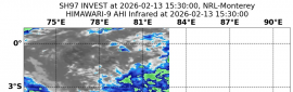
BoM降格澳式C2
IDW24100
Australian Bureau of Meteorology
Tropical Cyclone Warning Centre
Transmitters serving the Onslow area are requested to USE the Standard
Emergency Warning Signal before broadcasting the following warning.
TOP PRIORITY FOR IMMEDIATE BROADCAST
TROPICAL CYCLONE ADVICE NUMBER 35
Issued at 2:13 pm WST on Sunday 8 February 2026
Headline:
Tropical Cyclone Mitchell (21U) has weakened slightly as it approaches the far
west Pilbara coast.
Areas Affected:
Warning zone: Onslow to Carnarvon, including Exmouth, and extending inland
through the western Pilbara and northwest Gascoyne.
Watch zone: Wooramel Roadhouse to Overlander Roadhouse, including Denham, and
extending to inland parts of the western Gascoyne, including Gascoyne Junction.
Cancelled zone: Mardie.
Details of Tropical Cyclone Mitchell 21U at 2:00 pm AWST:
Intensity: Category 2, sustained winds near the centre of 110 kilometres per
hour with wind gusts to 155 kilometres per hour.
Location: within 30 kilometres of 21.2 degrees South 114.7 degrees East,
estimated to be 65 kilometres northwest of Onslow and 100 kilometres northeast
of Exmouth.
Movement: southwest at 16 kilometres per hour.
Tropical Cyclone Mitchell (21U) has weakened slightly and is now at category 2
intensity. It is expected to maintain its strength as it continues to track
towards the southwest during this afternoon and evening.
Mitchell is forecast to approach the far west Pilbara coast during the
afternoon while remaining over water, with possible landfall close to Exmouth
late this evening or early Monday morning.
Hazards:
DESTRUCTIVE WIND GUSTS to 155 km/h are possible over coastal areas near Onslow
this afternoon, and are expected to develop over North West Cape (including
Exmouth) this evening. Destructive wind gusts may extend further down the coast
to Coral Bay on Monday morning.
GALES with DAMAGING WIND GUSTS to 120 km/h are occurring along coastal areas
from west of Mardie to Exmouth. GALES with DAMAGING WIND GUSTS to 120 km/h are
forecast to extend further south to Coral Bay and inland parts of the western
Pilbara and far northern Gascoyne later this evening or overnight. During
Monday, GALES should extend further south through the western Gascoyne,
possibly developing over Carnarvon, Denham and Gascoyne Junction during Monday
afternoon and evening.
Widespread moderate to HEAVY RAINFALL which may lead to FLASH FLOODING is
likely over the west Pilbara coast, extending to the west Gascoyne region on
Monday. Local areas of INTENSE rainfall leading to SEVERE FLASH FLOODING may
occur around the west Pilbara coast around Onslow from later this afternoon,
extending to Exmouth and Ningaloo, including the North West Cape, later this
evening.
ABNORMALLY HIGH TIDES are expected along the west Pilbara coast, including
Onslow and Exmouth. Tides are likely to rise above the normal high tide mark
this afternoon and again on Monday morning's high tide, causing FLOODING of
low-lying coastal areas. ABNORMALLY HIGH TIDES are expected along the Gascoyne
coast, including Carnarvon, with Monday afternoon's high tide.
Recommended Action:
Ensure you know what to do in a cyclone. For the latest DFES community alerts
and warnings visit www.emergency.wa.gov.au or download the Emergency WA app.
Next Advice:
The next advice will be issued by 3:00 pm AWST Sunday 08 February.
Cyclone advices and DFES Alerts are available by dialling 13 DFES (13 3337)
A map showing the track of the cyclone is available at:
http://www.bom.gov.au/cyclone 
|
|


 照妖鏡
照妖鏡