開啟輔助訪問
 找回密碼
 立即加入

08E.Douglas 2020首颶 直襲夏威夷 殘餘進入西太平洋

簽到天數: 1650 天

[LV.Master]伴壇終老

老農民版夜神月|2020-7-23 14:49 | 顯示全部樓層
霧峰追風者 發表於 2020-7-23 11:54
首颶不是黃蜂颱風嗎? JTWC評價C3。

引述維基百科的熱帶氣旋條目來說明一下
習慣上,不同的地區熱帶氣旋有不同的稱呼。人們稱西北太平洋及其沿岸地區(例如中國大陸東南沿岸、香港、澳門、臺灣、朝鮮、韓國、日本、越南、菲律賓等地)的熱帶氣旋為「颱風」而大西洋和東北太平洋及其沿岸地區的熱帶氣旋則依強度稱為熱帶性低氣壓、熱帶風暴或「颶風」。氣象學上,則只有中心風力達到每小時118公里或以上(颶風程度)的熱帶氣旋才會被冠以「颱風」或「颶風」等名字。

南半球在不引致誤會時,中間會採用「氣旋」(英語:Cyclone)一字作「熱帶氣旋」(Tropical Cyclone)的簡稱。北印度洋地區則慣用「氣旋風暴」(英語:Cyclonic Storm)及相關分級稱呼熱帶氣旋。
以上
所以黃蜂颱風應該算是「颱風」
而Douglas才是一個「颶風」
所以08E.Douglas確實是2020年風季第一個颶風唷

點評

我只想說,這裡是討論的場合,並不應該是讓你耍流氓的地方.僅此,請你自制!適可而止  發表於 2020-7-23 17:47
你就不把JTWC 放在眼裡了,還要講什麼  發表於 2020-7-23 17:42
.....先生你講不講道理的呀?  發表於 2020-7-23 17:39
喔喔,妳爽就好  發表於 2020-7-23 17:35
回復

使用道具 舉報

簽到天數: 1650 天

[LV.Master]伴壇終老

老農民版夜神月|2020-7-23 17:37 | 顯示全部樓層
NHC23/09Z升格MH(C3以上颶風),定強105KT,並預測12H內將達110KT
WTPZ43 KNHC 230842
TCDEP3

Hurricane Douglas Discussion Number  12
NWS National Hurricane Center Miami FL       EP082020
1100 PM HST Wed Jul 22 2020

Douglas has rapidly intensified since earlier today, with satellite
images showing a ragged, but nearly clear eye surrounded by cold
cloud tops of -70 C. There appears to be a little dry air intrusion
across the northern portion of the circulation, which is limiting
the amount of deep convection wrapping around that part of the eye.
Both Dvorak intensity estimates from TAFB and SAB have increased to
5.5/100 kt, while the ADT and SATCON estimate averages have
increased to 105 kt. Since the cyclone's appearance has improved
slightly since these estimates arrived, the advisory initial
intensity has been set at 105 kt, making Douglas a major hurricane.

The environmental conditions supporting the rapid intensification
appear at their best at this time as the cyclone is over SSTs of
over 28 C, with low wind shear in a moist air mass. If the cyclone
can fight off the dry air in the northern semicircle, some
additional strengthening is possible, especially early Thursday.
However, Douglas should be gradually moving into a less hospitable
environment for strengthening over the next few days, and in 36 h
the cyclone is forecast to cross the 26 C SST isotherm and into a
region where the 500-700 mb relative humidity is less than 60
percent. Later on in the forecast period, wind shear is also
expected to be on the increase. These factors should cause the
cyclone to gradually weaken beginning Thursday night. Douglas is
expected to be at or near hurricane intensity as it approaches the
Hawaiian Islands on Sunday, and all interests there should monitor
forecasts as they evolve over the next few days. The NHC forecast
was adjusted higher in the first 12 h based on the initial
intensity, and is very close to the previous forecast after that
time. This intensity forecast closely follows the various consensus
aids.

The initial motion is west-northwest or 295/15. Douglas should
continue on a general west-northwestward motion for the next few
days, steered by a large mid-level ridge extending across much of
the central and eastern North Pacific. The cyclone is then forecast
to turn more toward the west late in the forecast period as it
moves near the Hawaiian Islands. The track guidance is tightly
clustered and the new NHC is little changed from the previous one.

Key Messages:

1.  Douglas is expected to move near or over portions of the
Hawaiian Islands this weekend, and there is an increasing chance
that strong winds and heavy rainfall could affect portions
of the state beginning on Sunday.  Interests on the Hawaiian
Islands should continue to monitor the progress of Douglas and the
official forecasts as they evolve over the next few days.


FORECAST POSITIONS AND MAX WINDS

INIT  23/0900Z 13.1N 134.0W  105 KT 120 MPH
12H  23/1800Z 14.0N 136.3W  110 KT 125 MPH
24H  24/0600Z 15.3N 139.5W  110 KT 125 MPH
36H  24/1800Z 16.5N 142.5W  105 KT 120 MPH
48H  25/0600Z 17.6N 145.5W   90 KT 105 MPH
60H  25/1800Z 18.6N 148.5W   80 KT  90 MPH
72H  26/0600Z 19.4N 151.4W   70 KT  80 MPH
96H  27/0600Z 20.5N 157.1W   55 KT  65 MPH
120H  28/0600Z 21.0N 163.7W   45 KT  50 MPH

$$
Forecaster Latto

122240nnbjjl7buubuwjju.jpg 170554pzsl72imd255p263.png
goes17_vis-swir_08E_202007230705.gif goes17_ir_08E_202007230655.gif
回復

使用道具 舉報

該用戶從未簽到

副熱帶高壓脊|2020-7-23 23:50 來自手機 | 顯示全部樓層
GFS認為即將巔峰,氣壓降去960hpa,預料趨向夏夷,但當時減弱為輕颱,之後有機會入西太,但強度可能會降為熱低壓,如果系統順利以輕颱姿態入西太,不知颱風競賽算不算為颱風,如果算,這次水氣也有點波折。香港的伺服器入不到JTWC或NOAA,靠台灣的朋友貼上來
0C0C29CA-41D1-4CD4-851F-D0562D008BC1.png
A15C62B2-9683-4294-B657-807E9D2CB7E9.png

點評

若以颱風強度進入西太就會變成西太第三號颱風,名字則是沿用東太的名字,不過模式並不看好,若減弱熱低再到西太增強為颱風,名字就會用西太的  發表於 2020-7-24 12:23
不算,如果以熱帶性低氣壓進入西太再重新增強就算  發表於 2020-7-24 00:22
回復

使用道具 舉報

簽到天數: 1650 天

[LV.Master]伴壇終老

老農民版夜神月|2020-7-24 11:16 | 顯示全部樓層
NHC24/03Z升格Douglas為四級颶風,定強115KT,中心最低氣壓954百帕,並預測已達巔峰
e2574a90f603738d14e8e176a41bb051f919ec9f.jpg 869251da81cb39db277e8a02c7160924aa1830fa.jpg goes17_vis_08E_202007240035.gif goes17_ir_08E_202007240015.gif
goes17_ir-dvorak_08E_202007240025.gif

評分

參與人數 1水氣能量 +9 收起 理由
b997755 + 9 好美!

查看全部評分

回復

使用道具 舉報

簽到天數: 3818 天

[LV.Master]伴壇終老

甜心|2020-7-24 15:32 來自手機 | 顯示全部樓層
霧峰追風者 發表於 2020-7-22 23:26

要注意一下喔請恕我直言,您從來都不覺得你的回帖文很有問題嗎?

為何都只有複貼的發報文沒有其他內容呢?...

點評

報文裡都有內容 我還要回復尛0.0  發表於 2020-7-24 21:19
回復

使用道具 舉報

簽到天數: 3818 天

[LV.Master]伴壇終老

甜心|2020-7-24 15:37 來自手機 | 顯示全部樓層
老農民版夜神月 發表於 2020-7-23 17:37
NHC23/09Z升格MH(C3以上颶風),定強105KT,並預測12H內將達110KT

差不多是我們這邊中颱上限到強颱下限的強度,不過如果直襲夏威夷的話絕對會比台灣遭遇中限以上強颱還慘。

必竟夏威夷沒有中央山脈又是在大海中央的群島,沒有大陸跟高大山脈的屏障很可怕的。
回復

使用道具 舉報

該用戶從未簽到

副熱帶高壓脊|2020-7-24 16:34 來自手機 | 顯示全部樓層
甜心 發表於 2020-7-24 15:37
差不多是我們這邊中颱上限到強颱下限的強度,不過如果直襲夏威夷的話絕對會比台灣遭遇中限以上強颱還慘。 ...

從沒預計過 Douglas 以巔峰登陸夏威夷,只預計Douglas 以輕颱下限登陸,沒你想像中強,不過災情應該是有的,畢竟夏威夷不是常常有風打。
我猜霧峰應該真的只是追風者,在打風才出去追風,所以分析不多
回復

使用道具 舉報

簽到天數: 53 天

[LV.5]常住居民I

天篷大元帥|2020-7-24 16:58 | 顯示全部樓層
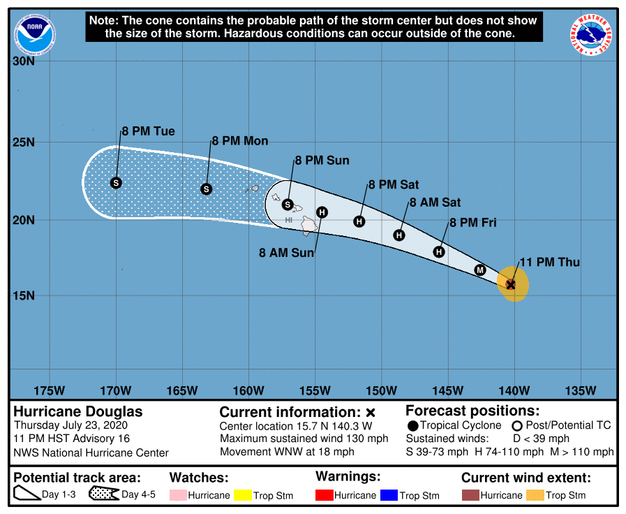
由於離開國家颶風中心責任區,國家颶風中心對道格拉斯發出最後一報。
原文:
000
WTPZ43 KNHC 240848
TCDEP3

Hurricane Douglas Discussion Number  16
NWS National Hurricane Center Miami FL       EP082020
1100 PM HST Thu Jul 23 2020

Douglas continues to look impressive in satellite images, with a
clear eye and symmetric convection in all quadrants. Broad outflow
channels extend about 300 n mi in every direction from the cyclone,
indicative of nearly zero wind shear. The latest Dvorak CI values
from TAFB and SAB, as well as the recent UW/CIMSS ADT estimates  
are all T6.0, which supports keeping the initial advisory intensity
at 115 kt.

Douglas is crossing the 26 C isotherm, and will continue to move
over relatively cooler waters of about 25 C over the next day or so.
This should cause the cyclone to begin weakening very soon. In about
48 h, Douglas is forecast to move back across the 26 C isotherm, but
at the same time the cyclone is forecast to begin encountering a
drier, more stable airmass and increasing vertical wind shear.
Despite the warmer waters, these other more hostile environmental
factors are expected to cause Douglas to gradually weaken for the
remainder of the 5-day forecast period. The latest NHC forecast is
changed little from the previous advisory, and is very close to a
blend of the corrected consensus HCCA and the IVCN/ICON consensus
aids.

Douglas is still moving quickly west-northwestward or 295/16 kt.
A mid-level ridge to the north of the cyclone should keep moving
the cyclone in the same general direction over the next couple of
days. Over the weekend, as Douglas approaches the Hawaiian Islands,
a more westward motion is forecast as another ridge builds to the
north of the cyclone. There is some notable spread in the model
guidance now compared to yesterday as Douglas approaches the
Hawaiian Islands. The faster and southernmost guidance from the
ECMWF takes the center of the cyclone over the big island, while the
northernmost GFS and HWRF take the cyclone just north of the island
chain. The other guidance, including the track consensus aids lie in
between those solutions. The latest NHC forecast was nudged
slightly northward between 48 h and 96 h, but still remains south
of the consensus aids during those time periods. Otherwise, the NHC
forecast was little changed from the previous one.  

This is the last advisory issued by the National Hurricane Center
on Douglas.  Future information on this system can be found in
Forecast/Advisories issued by the Central Pacific Hurricane Center
beginning at 1500 UTC under AWIPS header HFOTCMCP2 and WMO header
WTPA22 PHFO.
  For information specific to the Hawaiian Islands,
users should continue to consult products from the National Weather
Service Forecast Office in Honolulu, Hawaii, at www.weather.gov/hfo.


Key Messages:

1.  Douglas is expected to move near or over portions of the
Hawaiian Islands this weekend, and there is an increasing chance
that strong winds, dangerous surf, and heavy rainfall could affect
portions of the state beginning Saturday night or Sunday.
Interests on the Hawaiian Islands should continue to monitor the
progress of Douglas and the official forecasts as they evolve over
the next few days. Watches could be issued on Friday.


FORECAST POSITIONS AND MAX WINDS

INIT  24/0900Z 15.7N 140.3W  115 KT 130 MPH
12H  24/1800Z 16.7N 142.6W  105 KT 120 MPH
24H  25/0600Z 17.9N 145.7W   95 KT 110 MPH
36H  25/1800Z 19.0N 148.7W   85 KT 100 MPH
48H  26/0600Z 19.9N 151.7W   75 KT  85 MPH
60H  26/1800Z 20.5N 154.5W   65 KT  75 MPH...NEAR HAWAII
72H  27/0600Z 21.0N 157.1W   60 KT  70 MPH...NEAR HAWAII
96H  28/0600Z 22.0N 163.2W   50 KT  60 MPH
120H  29/0600Z 22.4N 170.0W   45 KT  50 MPH

$$
Forecaster Latto
機器翻譯(僅參考):
000
WTPZ43 KNHC 240848
TCDEP3

道格拉斯颶風討論第16號
NWS邁阿密颶風中心美國佛羅里達州EP082020
1100 PM HST 2020年7月23日星期四

道格拉斯在衛星圖像中的表現仍然令人印象深刻,
在所有像限中都有清晰的眼睛和對稱的對流。寬大的流出
通道從旋風分離器沿每個方向延伸約300 n mi,這
表明風切變幾乎為零。
TAFB和SAB 的最新Dvorak CI值以及UW / CIMSS ADT的最新估算   
均為T6.0,這有助於將初始諮詢強度保持
在115 kt。

道格拉斯(Douglas)正在穿越26 C等溫線,並將繼續發展
在第二天左右,在大約25℃的相對涼爽的水上。
這將導致旋風分離器很快開始減弱。
預計在約48小時內,道格拉斯將回過26 C等溫線,但
同時預計旋風將開始遇到
更乾燥,更穩定的空氣質量和垂直風切變的增加。
儘管水溫較高,但
預計
在5天的預測期的其餘時間內,這些其他更不利的環境因素也會導致道格拉斯逐漸減弱。最新的NHC預測
與先前的建議相比變化不大,並且非常接近
校正後的HCCA共識和IVCN / ICON共識
幫助的混合。

道格拉斯仍在迅速向西北偏西或295/16 kt前進。
在接下來的
幾天
中,氣旋北側的中層山脊應繼續沿相同的總體方向移動氣旋。週末,道格拉斯(Douglas)接近夏威夷群島(Hawaiian Islands)時,
由於旋風以北的
另一座山脊逐漸形成,預計將向西運動。
現在,與道格拉斯接近
夏威夷群島時相比,與昨天相比,該模型指南中有一些明顯的差異。來自
ECMWF 的更快,最南端的引導使大島上的氣旋成為中心,而最
北端的GFS和HWRF則使氣旋位於島的北邊
鏈。其他指南(包括跟踪共識幫助)位於
這些解決方案之間。NHC的最新預報
在48小時至96小時之間略微向北移動,但
在那些時間段內仍處於共識援助的南部。否則,NHC的
預測與之前的預測幾乎沒有變化。  

這是
道格拉斯國家颶風中心發布的最新諮詢。有關該系統的更多信息,請參見
中央太平洋颶風中心發布的“預測/建議”,
始於1500 UTC,位於AWIPS標頭HFOTCMCP2和WMO標頭
WTPA22 PHFO下
。有關夏威夷群島的特定信息,
用戶應繼續諮詢National Weather的產品。
夏威夷火奴魯魯服務預報辦公室,網址:www.weather.gov/hfo


重要信息:

1.預計
本週末道格拉斯將在夏威夷群島的部分區域附近或上方移動,並且
強風,危險的海浪和強降雨可能影響
該州部分地區的機會從星期六晚上或星期日開始增加。
夏威夷群島的利益應繼續關注
道格拉斯的進展以及
未來幾天的官方預測。手錶可以在星期五發行。


預測位置和最大

風速初始化24 / 0900Z 15.7N 140.3W 115 KT 130 MPH
12H 24 / 1800Z 16.7N 142.6W 105 KT 120 MPH
24H 25 / 0600Z 17.9N 145.7W 95 KT 110 MPH
36H 25 / 1800Z 19.0N 148.7W 85 KT 100 MPH
48H 26 / 0600Z 19.9N 151.7W 75 KT 85 MPH
60H 26 / 1800Z 20.5N 154.5W 65 KT 75 MPH ... Near HAWAII
72H 27 / 0600Z 21.0N 157.1W 60 KT 70 MPH ...近夏威夷
96H 28 / 0600Z 22.0N 163.2W 50 KT 60 MPH
120H 29 / 0600Z 22.4N 170.0W 45 KT 50 MPH

$$
預報員拉托

道格拉斯.png
回復

使用道具 舉報

快速回覆
您需要登錄後才可以回帖 登錄 | 立即加入

本版積分規則

本平台僅供學術討論之用,預報應以氣象局為準

威普網站虛擬主機贊助公司

臺灣第一個天氣類型社群平台 即時天氣資訊、精準颱風動態

線上客服
FB傳送訊息
廣告行銷
精準行銷 物超所值
官方粉專
發佈 快速回復 返回頂部 返回列表