開啟輔助訪問
 找回密碼
 立即加入

08E.Douglas 2020首颶 直襲夏威夷 殘餘進入西太平洋

簽到天數: 1650 天

[LV.Master]伴壇終老

2020-7-19 21:24 | 顯示全部樓層
  基本資料  
編號    :08 E
擾動編號日期:2020 07 19 20
撤編日期  :2020 07 30 14
90E.INVEST.25kts.1009mb.15.2N.116.8W

20200719.1300.goes-17.ir.90E.INVEST.25kts.1009mb.15.2N.116.8W.100pc.jpg
  NHC:10%
2. Disorganized showers and thunderstorms located about 700 miles
southwest of the southern tip of the Baja California peninsula are
associated with a tropical wave.  Environmental conditions are
expected to be conducive for gradual development of this system
through the week while it moves west-southwestward and then
westward at about 10 mph.
* Formation chance through 48 hours...low...10 percent.
* Formation chance through 5 days...low...30 percent.

two_pac_2d2.png two_pac_5d2.png

巔峰強度:
東太:115KT/954hPa
中太:105KT/962hPa

評分

參與人數 1水氣能量 +15 +1 收起 理由
king111807 + 15 + 1 熱帶擾動首帖

查看全部評分

回復

使用道具 舉報

簽到天數: 2141 天

[LV.Master]伴壇終老

周子堯@FB|2020-7-20 15:40 | 顯示全部樓層
評級提升至Medium,有小幅發展機會
ZCZC MIATWOEP ALL
TTAA00 KNHC DDHHMM

Tropical Weather Outlook
NWS National Hurricane Center Miami FL
1100 PM PDT Sun Jul 19 2020

For the eastern North Pacific...east of 140 degrees west longitude:

2. A low pressure system producing an area of thunderstorms more than
800 miles southwest of the southern tip of the Baja California
peninsula continues to show signs of organization.  Environmental
conditions are expected to be conducive for development of this
system, and a tropical depression could form during the next couple
of days while it moves west-southwestward and then westward at
about 10 mph.
* Formation chance through 48 hours...medium...50 percent.
* Formation chance through 5 days...high...80 percent.

Forecaster Stewart
two_pac_2d2.png
20200720.0710.goes-17.ir.90E.INVEST.25kts.1008mb.14.3N.119.3W.100pc.jpg


回復

使用道具 舉報

簽到天數: 1650 天

[LV.Master]伴壇終老

老農民版夜神月|2020-7-20 17:24 | 顯示全部樓層
JTWC20/0900Z發布TCFA
WTPN22 PHNC 200900
MSGID/GENADMIN/JOINT TYPHOON WRNCEN PEARL HARBOR HI//
SUBJ/TROPICAL CYCLONE FORMATION ALERT (INVEST 90E)//
RMKS/
1. FORMATION OF A SIGNIFICANT TROPICAL CYCLONE IS POSSIBLE WITHIN
170 NM EITHER SIDE OF A LINE FROM 14.6N 119.0W TO 12.1N 126.2W
WITHIN THE NEXT 12 TO 24 HOURS. AVAILABLE DATA DOES NOT JUSTIFY
ISSUANCE OF NUMBERED TROPICAL CYCLONE WARNINGS AT THIS TIME.
WINDS IN THE AREA ARE ESTIMATED TO BE 20 TO 25 KNOTS. METSAT
IMAGERY AT 200830Z INDICATES THAT A CIRCULATION CENTER IS LOCATED
NEAR 14.3N 119.3W. THE SYSTEM IS MOVING SOUTHWESTWARD AT 07
KNOTS.
2. REMARKS: AN AREA OF CONVECTION (INVEST 90E) HAS PERSISTED NEAR
14.3N 119.3W, APPROXIMATELY 1123 NM SOUTH OF SAN DIEGO, CALIFORNIA.
ANIMATED ENHANCED INFRARED SATELLITE IMAGERY AND A 200502Z MHS METOP-
B 89GHZ MICROWAVE IMAGE DEPICT A CONSOLIDATING LOW LEVEL CIRCULATION
(LLC) WITH FLARING CONVECTION ALONG THE SOUTHERN PERIPHERY ALONG
WITH FORMATIVE BANDING WRAPPING INTO THE CENTER OF THE DISTURBANCE.
A 200557Z ASCAT METOP-C PASS SHOWS 25 KT WINDS ASSOCIATED WITH THE
CONVECTION ALONG THE SOUTHWEST FLANK OF THE SYSTEM. UPPER-LEVEL
ANALYSIS REVEALS A FAVORABLE ENVIRONMENT FOR 90E WITH LOW VWS (<
15KTS), GOOD POLEWARD OUTFLOW, AND WARM SST (28-29C). GLOBAL DYNAMIC
MODELS ARE IN STRONG AGREEMENT THAT 99E WILL CONTINUE TRACKING WEST-
SOUTHWESTWARD AND INTENSIFY OVER THE NEXT 24-36 HOURS BEFORE
RECURVING TO A MORE WEST-NORTHWESTWARD TRACK. MAXIMUM SUSTAINED
SURFACE WINDS ARE ESTIMATED AT 20 TO 25 KNOTS. MINIMUM SEA LEVEL
PRESSURE IS ESTIMATED TO BE NEAR 1004 MB. THE POTENTIAL FOR THE
DEVELOPMENT OF A SIGNIFICANT TROPICAL CYCLONE WITHIN THE NEXT 24
HOURS IS HIGH.
3. THIS ALERT WILL BE REISSUED, UPGRADED TO WARNING OR CANCELLED BY
210900Z.//
NNNN
ep9020.gif
90E_200700sair.jpg goes17_ir_90E_202007200755_lat14.3-lon240.7.jpg
90E_gefs_latest.png
回復

使用道具 舉報

簽到天數: 1650 天

[LV.Master]伴壇終老

老農民版夜神月|2020-7-20 23:41 | 顯示全部樓層
NHC20/15Z升格其為08E,初報上望颶風,有可能成為今年風季首個颶風,後期將進入中太平洋
WTPZ43 KNHC 201452
TCDEP3

Tropical Depression Eight-E Discussion Number   1
NWS National Hurricane Center Miami FL       EP082020
500 AM HST Mon Jul 20 2020

Satellite imagery and overnight scatterometer data indicate that the
low pressure area to the southeast of Tropical Depression Seven-E
has a well-defined circulation and sufficient organized convection
to be considered a tropical depression.  Thus, advisories are being
initiated on Tropical Depression Eight-E.  The initial intensity is
30 kt based on the scatterometer data and a subjective Dvorak
intensity estimate from TAFB.

The initial motion is 240/6, with the depression being steered by a
portion of the subtropical ridge building between it and Tropical
Depression Seven-E.  This motion should persist with some
increase in forward speed for 24-36 h, followed by a turn toward
the west as the steering flow becomes more easterly.  This should
be followed by a turn toward the west-northwest after 60h.  The
track guidance is in good agreement on this scenario, and the NHC
forecast is in the middle of the guidance and close to the various
consensus models.

The cyclone is over warm sea surface temperatures and in a light
shear environment, and these conditions should persist for the next
several days.  The intensity guidance calls for steady
strengthening through about 72 h, and the NHC forecast follows this
trend near the upper edge of the intensity guidance envelope.  
The Rapid Intensification Indices of the SHIPS model suggest about
a 20-25 percent chance of RI during the first 72 h of the
forecast, so it is possible that the cyclone will strengthen more
than currently forecast.


FORECAST POSITIONS AND MAX WINDS

INIT  20/1500Z 13.7N 119.8W   30 KT  35 MPH
12H  21/0000Z 13.1N 121.0W   35 KT  40 MPH
24H  21/1200Z 12.4N 123.1W   40 KT  45 MPH
36H  22/0000Z 11.8N 125.7W   45 KT  50 MPH
48H  22/1200Z 11.7N 128.4W   55 KT  65 MPH
60H  23/0000Z 11.9N 131.1W   65 KT  75 MPH
72H  23/1200Z 12.7N 134.0W   70 KT  80 MPH
96H  24/1200Z 14.5N 139.5W   70 KT  80 MPH
120H  25/1200Z 16.5N 145.5W   60 KT  70 MPH

$$
Forecaster Beven
145417_5day_cone_with_line_and_wind.png
未命名.png 08E_201200sair.jpg
08E_intensity_latest.png
回復

使用道具 舉報

簽到天數: 601 天

[LV.9]以壇為家II

霧峰追風者|2020-7-21 11:34 | 顯示全部樓層
000
WTPZ43 KNHC 210235
TCDEP3

Tropical Storm Douglas Discussion Number   3
NWS National Hurricane Center Miami FL       EP082020
500 PM HST Mon Jul 20 2020

Satellite data indicate that the cyclone is strengthening.  The
system now has a small but well organized central dense overcast
with curved bands on the west side of the circulation.  All of the
satellite intensity estimates are of tropical storm strength, and
based on that data the initial intensity is raised to 35 kt, making
the system Tropical Storm Douglas.

The tropical storm is moving west-southwestward at 9 kt.  A
mid-level ridge situated to the north of Douglas off the northern
Baja California coast should cause the storm to gradually turn
westward during the next couple of days and then west-northwestward
beyond that time.  The models are in good agreement on this
scenario, and only small changes were made to the previous
prediction.

Douglas is expected to be in quite favorable conditions of low
vertical wind shear, high amounts of moisture, and warm SSTs during
the next few days.  Given these conducive environmental conditions
and the storm's improved and compact structure, steady or possibly
even rapid strengthening is possible during that time period.
After a few days, however, a combination of higher shear, slightly
cooler waters, and drier air should end the strengthening trend and
induce weakening.  The NHC intensity forecast lies near the higher
end of the guidance.  This forecast shows a faster rate of
strengthening in the short term and more weakening at the end of
the period compared to the previous forecast.


FORECAST POSITIONS AND MAX WINDS

INIT  21/0300Z 13.1N 121.6W   35 KT  40 MPH
12H  21/1200Z 12.5N 123.2W   45 KT  50 MPH
24H  22/0000Z 12.0N 125.6W   50 KT  60 MPH
36H  22/1200Z 11.9N 128.2W   60 KT  70 MPH
48H  23/0000Z 12.3N 130.8W   70 KT  80 MPH
60H  23/1200Z 13.2N 133.3W   75 KT  85 MPH
72H  24/0000Z 14.2N 136.1W   75 KT  85 MPH
96H  25/0000Z 15.9N 141.5W   60 KT  70 MPH
120H  26/0000Z 16.6N 147.0W   45 KT  50 MPH

$$
Forecaster Cangialosi
023616_5day_cone_no_line_and_wind.png
回復

使用道具 舉報

簽到天數: 601 天

[LV.9]以壇為家II

霧峰追風者|2020-7-22 23:26 | 顯示全部樓層
942
WTPZ43 KNHC 221456
TCDEP3

Hurricane Douglas Discussion Number   9
NWS National Hurricane Center Miami FL       EP082020
500 AM HST Wed Jul 22 2020

Douglas has resumed strengthening, after remaining steady state for
almost 24 hours.  The system has developed a ragged eye during the
past couple of hours, although the cirrus from the inner-core
convection has been obscuring that feature somewhat.  There is a
wide range among the satellite intensity estimates--between 55 kt
and 77 kt--and the latest objective guidance is right at the
hurricane threshold.  Therefore, Douglas has been upgraded to a
65-kt hurricane, the first of the 2020 eastern Pacific season.  
During the period of reliable records, this is the 4th latest date
on which the first hurricane of the season has formed.

Douglas continues to move westward, or 265/13 kt, due south of a
mid-level ridge which extends from the Baja California peninsula to
140W.  This ridge is not expected to change much in strength or
position in the coming days, and Douglas is therefore expected to
move westward or west-northwestward, gradually gaining latitude,
during the entire forecast period.  There is very little spread
among the track models, although the new suite of models is a
little bit faster compared to the previous forecast.  The updated
NHC forecast has been adjusted accordingly, although it should be
noted that the overall forecast path has changed very little.

With Douglas's improved structure, low shear and warm sea surface
temperatures (28-29C) should support further strengthening during
the next 36 hours or so.  There's still a significant chance of
rapid intensification during that period, with the GFS- and
ECWMF-based SHIPS RI guidance both over 50 percent.  After that
time, oceanic heat content values fall below zero along Douglas's
forecast track, and it is likely that the hurricane would begin to
gradually weaken, although not considerably so since vertical shear
is not expected to increase until about day 4.  SHIPS, HCCA, and
the Florida State Superensemble are in very good agreement,
especially during the first part of the forecast period, and so the
NHC intensity forecast closely follows those solutions.  This new
forecast shows a slightly higher peak intensity compared to
previous forecasts.


Key Messages:

1.  Douglas is expected to move near or over portions of the
Hawaiian Islands this weekend, and there is an increasing chance
that strong winds and heavy rainfall could affect portions
of the state beginning on Sunday.  Interests on the Hawaiian
Islands should continue to monitor the progress of Douglas.


FORECAST POSITIONS AND MAX WINDS

INIT  22/1500Z 11.8N 129.5W   65 KT  75 MPH
12H  23/0000Z 12.0N 131.4W   75 KT  85 MPH
24H  23/1200Z 13.1N 134.1W   85 KT 100 MPH
36H  24/0000Z 14.4N 137.0W   95 KT 110 MPH
48H  24/1200Z 15.7N 140.0W   90 KT 105 MPH
60H  25/0000Z 17.0N 143.0W   80 KT  90 MPH
72H  25/1200Z 18.0N 146.1W   70 KT  80 MPH
96H  26/1200Z 19.0N 152.0W   60 KT  70 MPH
120H  27/1200Z 20.0N 158.0W   50 KT  60 MPH

$$
Forecaster Berg
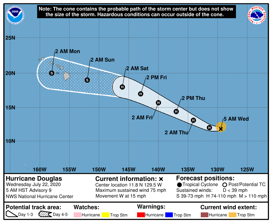
145820_5day_cone_no_line_and_wind.png
回復

使用道具 舉報

簽到天數: 1650 天

[LV.Master]伴壇終老

老農民版夜神月|2020-7-23 00:21 | 顯示全部樓層
08E.Douglas成為2020風季首個颶風,系統後期將直襲夏威夷群島,巔峰強度可能接近MH
08E_intensity_latest.png
goes17_vis-swir_08E_202007221225_lat11.6-lon231.1.jpg GOES15202020204hR1Ipy.jpg
goes17_ir_08E_202007221335.gif
回復

使用道具 舉報

簽到天數: 601 天

[LV.9]以壇為家II

霧峰追風者|2020-7-23 11:54 | 顯示全部樓層
老農民版夜神月 發表於 2020-7-23 00:21
08E.Douglas成為2020風季首個颶風,系統後期將直襲夏威夷群島,巔峰強度可能接近MH

首颶不是黃蜂颱風嗎? JTWC評價C3。
回復

使用道具 舉報

1234下一頁
快速回覆
您需要登錄後才可以回帖 登錄 | 立即加入

本版積分規則

本平台僅供學術討論之用,預報應以氣象局為準

威普網站虛擬主機贊助公司

臺灣第一個天氣類型社群平台 即時天氣資訊、精準颱風動態

線上客服
FB傳送訊息
廣告行銷
精準行銷 物超所值
官方粉專
發佈 快速回復 返回頂部 返回列表