|
|
 霧峰追風者|2020-8-21 01:48
|
顯示全部樓層
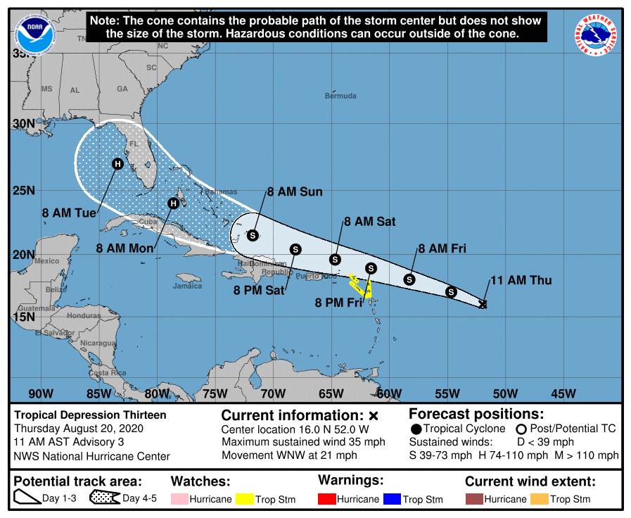
NHC 強度上望65KT不封頂,將直撲佛州。000
WTNT43 KNHC 201452
TCDAT3
Tropical Depression Thirteen Discussion Number 3
NWS National Hurricane Center Miami FL AL132020
1100 AM AST Thu Aug 20 2020
The organization of the depression has not changed much overnight
or this morning. An area of convection has persisted near the
estimated center, with some banding noted over the northwestern
portion of the circulation. An earlier SSMIS overpass was very
helpful in locating the center of what appears to be a small
circulation. A very recent ASCAT overpass has also revealed a
small circulation that is weak on the southeastern side, but with
winds near tropical storm strength to the north of the center. The
ASCAT data along with subjective Dvorak classification from TAFB and
SAB support maintaining the 30-kt initial intensity.
The depression continues to move briskly west-northwestward or
290/18 kt. The track forecast philosophy has not changed from
before. A subtropical ridge over the central Atlantic is forecast
to build westward and strengthen over the next several days. This
pattern is expected to keep the cyclone on a west-northwestward
heading throughout the forecast period. The dynamical models
continue to agree on this overall scenario, but there some
differences in both forward speed and how close it gets to the
Greater Antilles. In general, the models that indicate a stronger
cyclone favor a more northern track, while those which depicted a
weaker system are along the southern and faster side of the
envelope. The latest consensus aids are little north of the
previous track, and the new NHC forecast lies between the HFIP
corrected consensus and the TVCA multi-model consensus. This is
slightly north of the previous advisory, and not far from the GFS
ensemble mean.
The environment consisting of light to moderate vertical wind shear
is expected to allow for gradual strengthening over the next few
days, and the NHC forecast calls for the system to become a tropical
storm later today or tonight. The upper-level wind pattern is
expected to remain favorable in the latter portion of the forecast
period, and if there is minimal land interaction, a faster rate of
strengthening is possible at that time. The NHC intensity foreast
now shows the system becoming a hurricane by 96 hours, but it is a
little lower than the consensus aids at days 4 and 5 due to
uncertainty in how much the system will interact with the Greater
Antilles.
Key Messages:
1. Tropical storm conditions are possible across portions of the
northern Leeward Islands by Friday night, and Tropical Storm Watches
have been issued for some of these islands. Heavy rainfall is
likely across this area beginning late Friday.
2. There is a risk of tropical storm conditions in the Virgin
Islands and Puerto Rico Friday night and Saturday and Tropical
Storm Watches could be required for these islands later today.
Interests there should closely monitor the progress of this system.
3. The details of the long-range track and intensity forecasts are
more uncertain than usual since the system could move over portions
of the Greater Antilles this weekend. However, this system could
bring some storm surge, rainfall and wind impacts to portions of
Hispaniola, Cuba, the Bahamas, and Florida this weekend and early
next week. Interests there should monitor this system's progress
and updates to the forecast over the next few days.
FORECAST POSITIONS AND MAX WINDS
INIT 20/1500Z 16.0N 52.0W 30 KT 35 MPH
12H 21/0000Z 17.0N 54.7W 35 KT 40 MPH
24H 21/1200Z 18.0N 58.3W 40 KT 45 MPH
36H 22/0000Z 18.9N 61.6W 45 KT 50 MPH
48H 22/1200Z 19.6N 64.7W 50 KT 60 MPH
60H 23/0000Z 20.4N 68.1W 55 KT 65 MPH
72H 23/1200Z 21.5N 71.8W 60 KT 70 MPH
96H 24/1200Z 24.0N 78.6W 65 KT 75 MPH
120H 25/1200Z 27.0N 83.4W 65 KT 75 MPH
$$
Forecaster Brown 
|
|