開啟輔助訪問
 找回密碼
 立即加入

13L.Melissa 極快速增強 風眼開啟 升格C5 強勢威脅牙買加

簽到天數: 3308 天

[LV.Master]伴壇終老

king111807|2025-10-22 06:39 | 顯示全部樓層
NHC升格TS,命名Melissa,首報評價45節,巔峰上望70節

WTNT43 KNHC 211445
TCDAT3

Tropical Storm Melissa Discussion Number   1
NWS National Hurricane Center Miami FL       AL132025
1100 AM EDT Tue Oct 21 2025

Satellite images, regional Caribbean radar data, and surface
observations indicate that invest 98L has developed a well-defined
center and organized deep convection to be designated a tropical
cyclone.  A ship report that recently passed near the center of the
system reported a minimum pressure of about 1003 mb.  Satellite
imagery shows the system is asymmetric, with the low-level center
near the western edge of the central dense overcast.  The initial
intensity is set at 45 kt, based on a blend of the latest satellite
intensity estimates, marking the formation of Tropical Storm
Melissa.  An  Air Force Hurricane Hunter aircraft is scheduled to
investigate the system this afternoon, and their data should provide
a better assessment of Melissa's strength and structure.  

The system was moving very quickly westward over the past several
days, but it has slowed down significantly this morning, which has
likely helped Melissa form.  The initial motion is estimated to be
280/12 kt.  Melissa should continue to slow down and gradually turn
to the northwest and then north during the next couple of days
toward a weakness in the subtropical ridge.  This motion will likely
take the storm very near the southwestern tip of Haiti and Jamaica
by Thursday.  After that time, the guidance diverges significantly
with some models like the GFS and HWRF showing a motion to the
northeast into the weakness, while the other solutions show a stall
or a westward drift on the south side of a building ridge.  An
examination of the GFS, ECMWF, and Google DeepMind ensemble suites
suggest that the majority of the members show Melissa not moving
into the weakness and remaining in the Caribbean Sea throughout the
week and into the weekend.  The NHC official track forecast lies
between the Google DeepMind ensemble mean track and the correct
consensus aid, HCCA.

Melissa is expected to be over the very warm waters of the
Caribbean, but the models suggest that vertical wind shear will be
moderate with some dry air in the vicinity of the storm during the
next few days.  Based on these mixed signals, the strengthening
trend is expected to be slow and steady, not rapid.  However, the
future intensity of Melissa is linked to the track and since that is
quite uncertain beyond a couple of days, the strength of the storm
is also quite uncertain.  The NHC intensity forecast is in best
agreement with the HCCA model.

Key Messages:

1. Melissa is expected to bring heavy rainfall and the risk of
significant flash flooding and the danger of landslides to portions
of Haiti and the Dominican Republic through the weekend.

2. A Hurricane Watch has been issued for the southern coast and
Tiburon peninsula of Haiti.  A Tropical Storm Watch has been issued
for Jamaica.  Preparations to protect life and property should be
completed by Thursday.

3. There is significant uncertainty in the track and intensity
forecast of Melissa.  Interests elsewhere in Hispaniola and Cuba
should continue to monitor the latest forecasts.


FORECAST POSITIONS AND MAX WINDS

INIT  21/1500Z 14.3N  71.7W   45 KT  50 MPH
12H  22/0000Z 14.4N  72.8W   50 KT  60 MPH
24H  22/1200Z 14.8N  73.5W   55 KT  65 MPH
36H  23/0000Z 15.3N  74.2W   60 KT  70 MPH
48H  23/1200Z 15.7N  74.5W   60 KT  70 MPH
60H  24/0000Z 16.1N  74.6W   60 KT  70 MPH
72H  24/1200Z 16.5N  74.5W   60 KT  70 MPH
96H  25/1200Z 16.9N  74.5W   65 KT  75 MPH
120H  26/1200Z 17.2N  74.9W   70 KT  80 MPH

$$
Forecaster Cangialosi/Bucci
NHC.png
fnv3_98L_ensemble_2025102112.png
20252942050_GOES19-ABI-FL-GEOCOLOR-AL132025-1000x1000.jpg
回復

使用道具 舉報

簽到天數: 3308 天

[LV.Master]伴壇終老

king111807|2025-10-24 15:07 | 顯示全部樓層
NHC 03Z報,巔峰上望C4,逐漸進逼牙買加

000
WTNT43 KNHC 240237
TCDAT3

Tropical Storm Melissa Discussion Number  11
NWS National Hurricane Center Miami FL       AL132025
1100 PM EDT Thu Oct 23 2025

Melissa has gotten a little better organized this evening, with the
low-level center re-forming a little to the north close to a burst
of deep convection. However, tail Doppler radar data from a NOAA
Hurricane Hunter aircraft suggests the storm is still not
vertically aligned, and the circulation at 700 and 500 mb is still
poorly defined. The central pressure remains near 1001 mb, so the
initial intensity will be held at 40 kt. However, the aircraft wind
data suggest this could be a little generous.

The initial motion is now slowly northward, 355/3 kt. Melissa
remains trapped in an area of weak steering currents between
mid-level ridges to the southeast and northwest.  During the next
couple of days, the ridge to the northwest is forecast to build
eastward to the north of Melissa in the wake of a mid-latitude
shortwave trough currently moving eastward through the Bahamas.  
This evolution would cause Melissa to move slowly northward for the
next 24 h or so, followed by a westerly turn at a continued slow
forward speed.  The GFS and the HAFS regional hurricane models show
a more initial eastward motion possibly due to center re-formation,
and due to this they forecast a track east of Jamaica, followed by
an eventual northward motion toward eastern Cuba.  The ECMWF,
Canadian, UKMET, HFIP Corrected Consensus, and Google DeepMind
forecast a more westerly track that passes south of Jamaica,
followed by a northward turn near or west of the western end of the
island near the end of the forecast period. The HRWF, HMON, and the
other consensus models are in between these and forecast the center
to cross Jamaica. The new forecast continues to follow the more
westerly solution and is little changed from the previous forecast.
It should be noted that regardless of the exact track, the center
of Melissa is likely to pass dangerously close to Jamaica during
the next few days, and it could also come close to the southwestern
peninsula of Haiti.

Melissa is still feeling the effects of about 15 kt of westerly
shear, and between this and the disorganized structure only slow
strengthening is expected during the next 24 h. After that time, a
combination of more favorable upper-level winds and very warm sea
surface temperatures should allow considerable strengthening once
the cyclone gets better organized. The intensity guidance remains
in good agreement on the possibility of rapid intensification as
the center nears Jamaica, and the new intensity forecast is
unchanged from the previous forecast.  In addition, the tropical
cyclone is expected to grow significantly in size, and it will
likely be a large and dangerous hurricane towards the end of the
forecast period.


Key Messages:

1. Jamaica:  Due to Melissa’s slow motion, the risk of a prolonged
multi-day period of potentially damaging winds, heavy rainfall
resulting in life-threatening flash flooding and numerous
landslides, and storm surge continues to increase for Jamaica.
Preparations to protect life and property should be rushed to
completion, since strong winds and flooding rains could begin in
Jamaica by Saturday.

2. Haiti:  Heavy rainfall will result in catastrophic flash
flooding and landslides across southwestern Haiti by this weekend
into early next week. Extensive damage to roads and buildings is
expected, potentially isolating communities for an extended period
of time. This is a life-threatening situation and immediate
preparations to protect life and property should be taken.  Strong
winds could also potentially last for a day or more over the Tiburon
peninsula of Haiti.

3. Remainder of Hispaniola and Eastern Cuba: Heavy rainfall could
also produce significant, life-threatening flash flooding and
numerous landslides in southern Dominican Republic. Interests in
Cuba should monitor the progress of Melissa since the risk of heavy
rainfall, damaging winds, and storm surge appears to be increasing.


FORECAST POSITIONS AND MAX WINDS

INIT  24/0300Z 16.2N  75.5W   40 KT  45 MPH
12H  24/1200Z 16.4N  75.3W   45 KT  50 MPH
24H  25/0000Z 16.8N  75.2W   50 KT  60 MPH
36H  25/1200Z 17.2N  75.5W   60 KT  70 MPH
48H  26/0000Z 17.3N  76.0W   80 KT  90 MPH
60H  26/1200Z 17.4N  76.5W  100 KT 115 MPH
72H  27/0000Z 17.5N  77.2W  115 KT 130 MPH
96H  28/0000Z 17.7N  78.3W  125 KT 145 MPH
120H  29/0000Z 19.3N  78.5W  125 KT 145 MPH

$$
Forecaster Beven
240536_5day_cone_with_line_and_wind.png
fnv3_13L_ensemble_2025102400.png
rb-animated.gif
回復

使用道具 舉報

簽到天數: 3308 天

[LV.Master]伴壇終老

king111807|2025-10-26 09:10 | 顯示全部樓層
NHC升格C1,巔峰上看C5

000
WTNT43 KNHC 252100
TCDAT3

Hurricane Melissa Discussion Number  18
NWS National Hurricane Center Miami FL       AL132025
500 PM EDT Sat Oct 25 2025

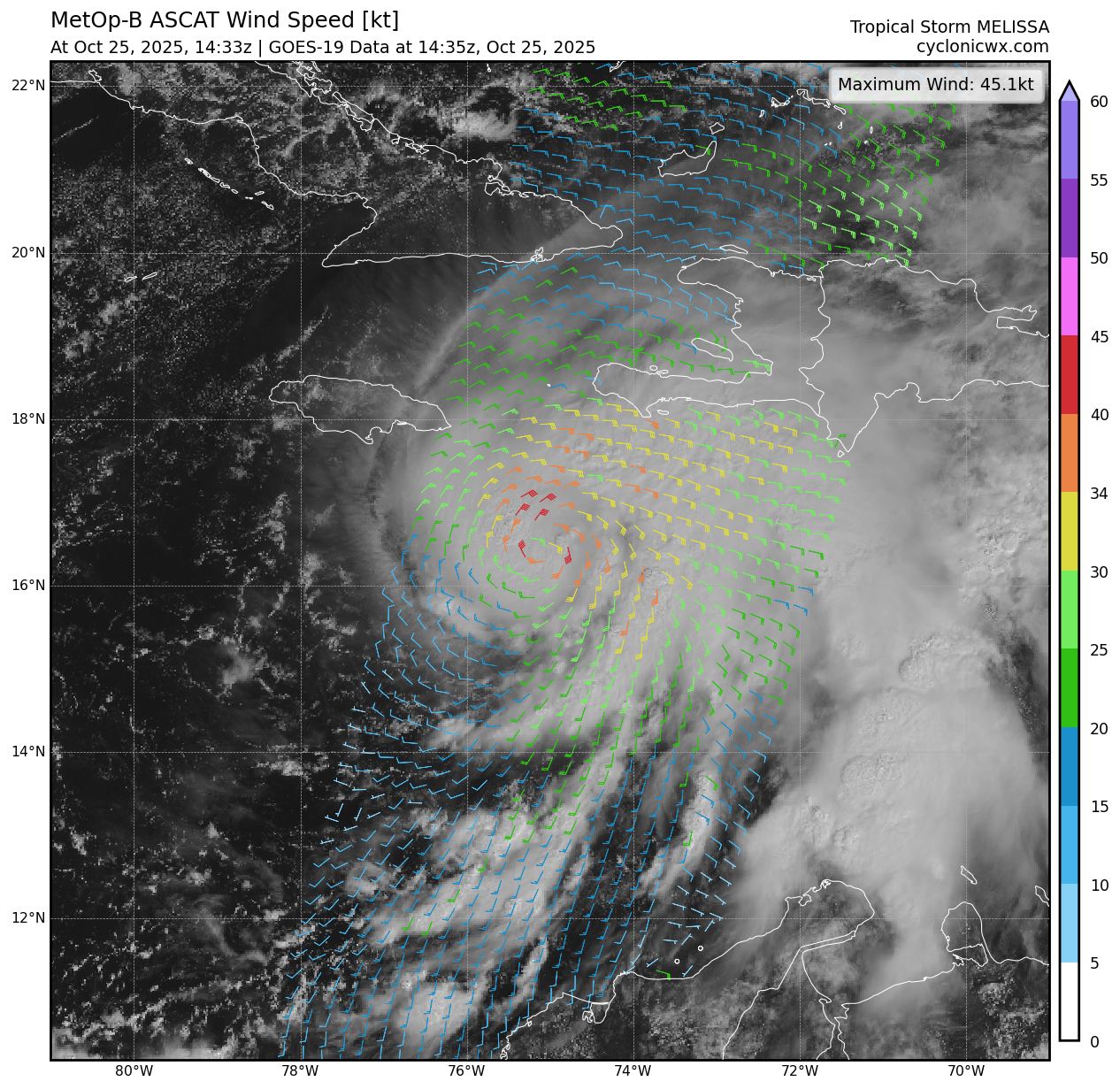
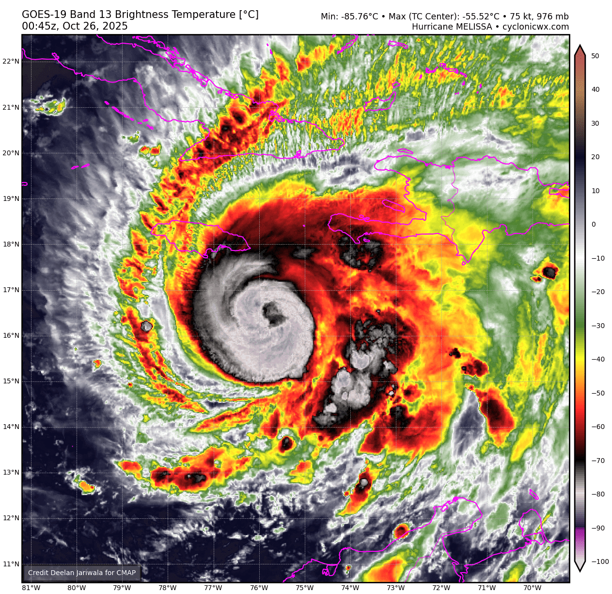
Melissa is likely beginning a period of rapid intensification (RI).
Since both the NOAA-P3 and Air Force Reserve C-130 aircraft sampled
the system this morning, the satellite presentation has continued to
improve, with cold -75 to -80 C cloud tops wrapping around the
center with hints of an eye starting to appear on visible images.
The eye is also becoming better defined on radar images out of
Jamaica with an overall diameter of around 20 n mi. In addition, an
earlier GMI microwave pass received after the prior advisory showed
a well-defined cyan ring on the 37-GHz, which is often a harbinger
of RI. Subjective Dvorak intensity estimates were T5.0/90 kt from
SAB, and T4.5/77 kt from TAFB. The objective estimates from UW-CIMSS
were a little lower, but are also quickly rising, and the initial
intensity will be set at 80 kt this advisory, blending these
intensity estimates.

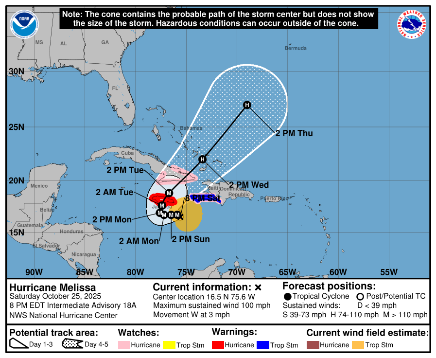
The hurricane now appears to be moving slowly westward, at an
estimated motion of 275/3 kt. A narrow mid-level ridge has built in
to the north of Melissa, and should be the main steering feature
over the next 24-48 hours to help move the hurricane slowly
westward. The deep-layer steering vector still has a slight
southward component, and it wouldn't be surprising to even see a
little south of due west motion occur, like the Google DeepMind
ensembles and ECMWF-AI model have been suggesting in the short-term
forecast. After the next couple of days, the ridging to the north
becomes quickly eroded by a shortwave trough moving across the
southeastern United States. The net result of this changing synoptic
pattern is that Melissa is expected to turn rather abruptly
northward and northeastward by the early to middle part of next
week. Compared to this morning, the track guidance has become more
tightly clustered in the across track direction, and even the 12z
GFS run, which was previous a eastward outlier, is now in better
agreement with the track guidance suite showing a direct landfall in
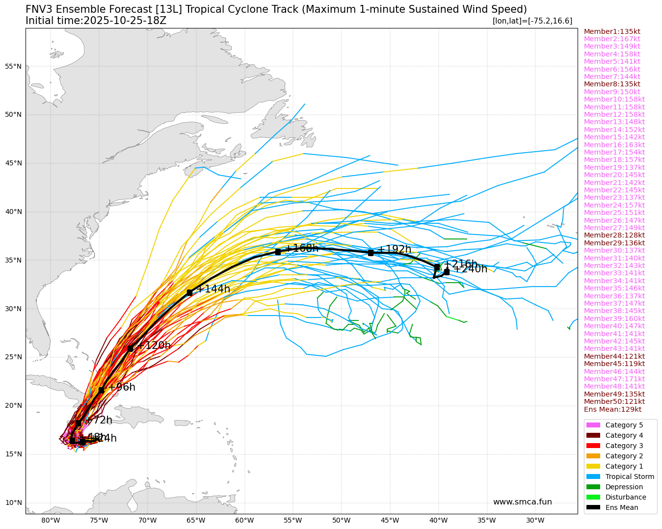
Jamaica. The main uncertainty is related to the amount of
acceleration that Melissa will undergo after it turns to the
northeast, and there remains large spread in the along-track
direction in both the deterministic and ensemble guidance in the day
3-5 time frame. The NHC track forecast is only slightly more
poleward compared to the prior forecast over the first 12-24 hours,
and convergences very close to the prior track thereafter. This
track is roughly a blend of the latest HCCA and GDMI track guidance.
On this track, this brings Melissa's core near Jamaica early on
Tuesday, and early on Wednesday along the eastern Cuba provinces,
where a hurricane watch is now in effect.

Rapid intensification appears to have started, and assuming Melissa
stays far enough south of Jamaica over the next couple of days,
there appear few impediments to its intensification in the
short-term. Both the hurricane-regional models and the Google
DeepMind ensembles suggest RI could continue for the next 36 to 48
hours. In fact, once again 4/5th s of the latter 50 member ensemble
are forecasting a peak intensity of Category 5 intensity. The 12z
HAFS-A run also showed a peak intensity of Category 5 in 48 hours,
and both HAFS-A/B have been suggesting a similar peak on and off
over the past few days. Given the current trends, the NHC intensity
forecast now shows a 140 kt peak in 48 hours, in general agreement
with this aggressive guidance. Afterwards, some inner-core
oscillations such as eyewall replacement cycles could lead to
fluctuations in intensity before its first landfall in Jamaica. It
is worth stressing that there is very little practical difference
in the overall impacts of a Category 4 or 5 landfall, and
Melissa is expected to be at least that intensity when moves over
Jamaica early next week. Land interaction will likely lead to some
weakening as it moves northeastward across Jamaica, but the storm
will likely also grow in size and is still forecast to be a major
hurricane when it moves over Cuba by the middle of this week. Only
after this period that southwesterly shear begins to increase in
earnest after it moves into the Southwestern Atlantic. The NHC
intensity forecast continues to be on the high end of the overall
guidance, siding with the higher intensity aids such as GDMI (which
has been the best preforming intensity guidance thus far this year)
and HAFS-A, but all the hurricane-regional models show a peak
intensity of at least Category 4 intensity.

Needless to say, there is a very serious situation, in terms of
catastrophic rainfall, wind, and storm surge hazards for Jamaica
and preparations should be rushed to completion in the area
currently under a Hurricane Warning.


Key Messages:

1. Jamaica:   A multi-day period of damaging winds and heavy
rainfall is expected to begin tonight, causing catastrophic and
life-threatening flash flooding and numerous landslides.  Extensive
infrastructural damage, long-duration power and communication
outages, and potentially prolonged isolation of communities is
likely.  A life-threatening storm surge is also likely along
portions of the southern coast early next week. All preparations
should be completed today.

2. Haiti:  Catastrophic and life-threatening flash flooding and
landslides are expected across southwestern Haiti into early next
week, likely causing extensive infrastructural damage and
potentially prolonged isolation of communities.  Strong winds could
also potentially last for a day or more over the Tiburon peninsula.

3. Dominican Republic: Heavy rainfall could produce catastrophic
flash flooding and numerous landslides in southern portions of the
country.

4. Eastern Cuba, Southeast Bahamas, and the Turks and Caicos:  
Monitor Melissa closely.  There is an increasing risk of a
significant storm surge, damaging winds, and heavy rainfall by the
middle of next week. In eastern Cuba, the risk of life-threatening
flash flooding and landslides is increasing. A Hurricane Watch is
now in effect for portions of eastern Cuba.


FORECAST POSITIONS AND MAX WINDS

INIT  25/2100Z 16.6N  75.5W   80 KT  90 MPH
12H  26/0600Z 16.7N  75.9W  100 KT 115 MPH
24H  26/1800Z 16.7N  76.5W  115 KT 130 MPH
36H  27/0600Z 16.7N  77.2W  135 KT 155 MPH
48H  27/1800Z 16.9N  77.6W  140 KT 160 MPH
60H  28/0600Z 17.6N  77.4W  130 KT 150 MPH
72H  28/1800Z 18.8N  76.7W  115 KT 130 MPH
96H  29/1800Z 22.0N  73.4W   90 KT 105 MPH
120H  30/1800Z 27.0N  69.0W   80 KT  90 MPH

$$
Forecaster Papin
252335_5day_cone_with_line_and_wind.png
ascat_wind_13L_202510251433.png
fnv3_13L_ensemble_2025102518.png
goes19_13L_ir_202510260045.png
回復

使用道具 舉報

簽到天數: 3308 天

[LV.Master]伴壇終老

king111807|2025-10-26 11:43 | 顯示全部樓層
NHC升格C3,快速增強,強勢威脅牙買加

448
WTNT43 KNHC 260252
TCDAT3

Hurricane Melissa Discussion Number  19
NWS National Hurricane Center Miami FL       AL132025
1100 PM EDT Sat Oct 25 2025

Reports from NOAA and Air Force Reserve Hurricane Hunter aircraft
indicate that Melissa is continuing rapid intensification.
The Air
Force aircraft reported flight-level winds of 115 kt in the north
eyewall of the 17 nm wide eye at 700 mb, along with a central
pressure of 967 mb
.  Based on these data, the initial intensity is
increased to 100 kt, making Melissa a category 3 major hurricane.

The initial motion is now just south of due west or 265/3 kt.  A
low- to mid-level ridge to the north of Melissa should steer the
hurricane generally westward at a slow forward speed during the
next 36 h or so. After that time, a deep-layer mid-latitude trough
moving through the southeastern United States will break the ridge,
with Melissa expected to turn northward and then recurve into the
mid-latitude southwesterly flow. The guidance is fairly well
clustered during the first 72 h, with Melissa expected to pass over
Jamaica in 48-60 h and then be near or over eastern Cuba around 72
h. Beyond 72 h, there is some speed and direction spread, but
overall the guidance is in good agreement that Melissa should
accelerate northeastward through portions of the Bahamas into the
Atlantic.  The new forecast track is a little to the south and west
of the previous track through 60 h and similar to the previous
track after that time.

Rapid intensification is expected to continue for the next 24-36 h,
and it is possible that during this time Melissa could intensify
even faster than what is currently forecast.
The regional hurricane
models show the cyclone peaking before it reaches Jamaica, and
based on this the new forecast keeps a 48-h peak intensity of 140
kt. Afterwards, some inner-core oscillations such as eyewall
replacement cycles could lead to fluctuations in intensity before
Melissa's first landfall in Jamaica. It must be noted that there is
very little practical difference in the overall impacts of a
Category 4 or 5 landfall, and Melissa is expected to be at least
that intensity when it moves over Jamaica.  Melissa should weaken
as it interacts with Jamaica and Cuba, although it is still forecast
to be a major hurricane when it nears Cuba. A faster weakening
should occur after passing Cuba when the cyclone encounters strong
shear over the southwestern Atlantic.

This remains a very serious situation, in terms of catastrophic
rainfall, wind, and storm surge hazards for Jamaica, and
preparations should be rushed to completion in the area currently
under a Hurricane Warning.


Key Messages:

1. Jamaica:  Seek shelter now.  A multi-day period of damaging
winds and heavy rainfall have begun and will cause catastrophic and
life-threatening flash flooding and numerous landslides.  Extensive
infrastructural damage, long-duration power and communication
outages, and isolation of communities are expected.
Life-threatening storm surge is likely along portions of the
southern coast early next week.

2. Haiti:  Catastrophic and life-threatening flash flooding and
landslides are expected across southwestern Haiti into early next
week, likely causing extensive infrastructural damage and isolation
of communities.  Strong winds could last for a day or more over the
Tiburon peninsula.

3. Dominican Republic: Heavy rainfall through the middle of next
week could produce catastrophic flash flooding and numerous
landslides in southern portions of the country.

4. Eastern Cuba, Southeast Bahamas, and the Turks and Caicos:
Monitor Melissa closely.  There is an increasing risk of a
significant storm surge, damaging winds, and heavy rainfall by the
middle of next week. In eastern Cuba, the risk of life-threatening
flash flooding and landslides is increasing. A Hurricane Watch is in
effect for portions of eastern Cuba.


FORECAST POSITIONS AND MAX WINDS

INIT  26/0300Z 16.4N  75.9W  100 KT 115 MPH
12H  26/1200Z 16.4N  76.4W  110 KT 125 MPH
24H  27/0000Z 16.4N  77.0W  125 KT 145 MPH
36H  27/1200Z 16.6N  77.5W  135 KT 155 MPH
48H  28/0000Z 17.2N  77.7W  140 KT 160 MPH
60H  28/1200Z 18.0N  77.2W  120 KT 140 MPH...INLAND JAMAICA
72H  29/0000Z 19.4N  76.1W  105 KT 120 MPH...OVER WATER
96H  30/0000Z 23.0N  72.8W   90 KT 105 MPH
120H  31/0000Z 28.0N  68.0W   75 KT  85 MPH

$$
Forecaster Beven

260251_5day_cone_with_line_and_wind.png
recon_AF301-1413A-MELISSA.png
13L_OTT.png
goes19_13L_rainbow_202510260325.png
goes19_13L_rbtop_202510260325.png
回復

使用道具 舉報

簽到天數: 3308 天

[LV.Master]伴壇終老

king111807|2025-10-26 18:22 | 顯示全部樓層
NHC升格C4,評價120節,ERI

000
WTNT43 KNHC 260856
TCDAT3

Hurricane Melissa Discussion Number  20
NWS National Hurricane Center Miami FL       AL132025
500 AM EDT Sun Oct 26 2025

Melissa is in the midst of a period of extreme rapid
intensification.
Its intensity has increased by 50 kt over the
past 24 hours and 35 kt over the past 12 hours.
  Data from the last
pass of an Air Force Reserve Hurricane Hunter aircraft through the
eye just before 1 AM EDT indicated that maximum winds had increased
to 105 kt and the pressure had fallen to 958 mb.  The eye has been
clearing out and warming since that time in infrared satellite
imagery, with the Dvorak data-T numbers from both TAFB and SAB up to
T6.0/115 kt at 2 AM EDT.  The intensity is estimated to be 120 kt at
the time of this advisory based on the latest AiDT and DPRINT
estimates.

The center had taken a west-southwestward jog over the past 12
hours, but more recent frames of satellite images suggest it is now
moving westward (270 degrees) at 4 kt.  There is very little change
in the forecast reasoning or the forecast track itself.  Over the
next 48 hours, Melissa is expected to make a slow westward to
north-northeastward recurvature just to the south of Jamaica, likely
reaching the island's southern coast Tuesday morning.  An
acceleration toward the northeast is expected after 48 hours when
Melissa is picked up by a trough moving off the southeast coast of
the United States, and this motion should bring the center across
southeastern Cuba late Tuesday or early Wednesday, across the
southeastern Bahamas later on Wednesday, and then reaching the
vicinity of Bermuda on Friday.

It's assumed that the current period of rapid intensification will
continue, and Melissa could reach category 5 intensity by tonight.

An eyewall replacement would be likely to occur at some point over
the next couple of days, which would cause a decrease or at least
fluctuations in Melissa's intensity after 24 hours.  Regardless,
Melissa is forecast to reach Jamaica as a category 4 hurricane,
which will only compound any damages caused by heavy rainfall and
flooding over the next 2 days.  Melissa is likely to weaken a
little during its passage across Jamaica, but intensity guidance
suggests that it will likely still be a major hurricane when it
reaches southeastern Cuba late Tuesday and the southeastern Bahamas
on Wednesday.  Stronger shear should cause the storm to weaken
below major hurricane strength on days 4 and 5 while over the
western Atlantic.


Key Messages:

1. Jamaica:  Seek shelter now.  Damaging winds and heavy rainfall
today and on Monday will cause catastrophic and life-threatening
flash flooding and numerous landslides before the strongest winds
arrive Monday night and Tuesday morning.  Extensive infrastructural
damage, long-duration power and communication outages, and isolation
of communities are expected. Life-threatening storm surge is likely
along portions of the southern coast Monday night and Tuesday
morning.

2. Haiti:  Catastrophic and life-threatening flash flooding and
landslides are expected across southwestern Haiti through midweek,
likely causing extensive infrastructural damage and isolation
of communities. Although winds are temporarily decreasing on the
Tiburon peninsula, they could increase again across much of western
Haiti on Tuesday.

3. Dominican Republic: Heavy rainfall through midweek could produce
catastrophic flash flooding and numerous landslides in southern
portions of the country.

4. Eastern Cuba, Southeast Bahamas, and the Turks and Caicos:
Monitor Melissa closely.  There is an increasing risk of a
significant storm surge, damaging winds, and heavy rainfall by the
middle of the week. In eastern Cuba, the risk of life-threatening
flash flooding and landslides is increasing. A Hurricane Watch is in
effect for portions of eastern Cuba.


FORECAST POSITIONS AND MAX WINDS

INIT  26/0900Z 16.3N  76.3W  120 KT 140 MPH
12H  26/1800Z 16.3N  76.8W  130 KT 150 MPH
24H  27/0600Z 16.5N  77.5W  140 KT 160 MPH
36H  27/1800Z 16.8N  77.9W  140 KT 160 MPH
48H  28/0600Z 17.5N  77.7W  135 KT 155 MPH...JUST SOUTH OF JAMAICA
60H  28/1800Z 18.7N  76.8W  120 KT 140 MPH...JUST NORTH OF JAMAICA
72H  29/0600Z 20.5N  75.4W  105 KT 120 MPH...OVER SE CUBA
96H  30/0600Z 24.8N  71.6W   95 KT 110 MPH...OVER WATER
120H  31/0600Z 30.3N  66.2W   80 KT  90 MPH

$$
Forecaster Berg

260855_5day_cone_with_line_and_wind.png
fnv3_13L_ensemble_2025102600.png
recon_AF301-1413A-MELISSA.png
20251026_040714_AL132025_gmi_GPM_color89_124kts_100p00_res1p0-cr100-akima-bgInfr.png
13L_89H_20251026040714.jpeg
13L_BW.png
13L_AWV.png
回復

使用道具 舉報

簽到天數: 582 天

[LV.9]以壇為家II

蜜露|2025-10-26 22:23 | 顯示全部樓層
本帖最後由 蜜露 於 2025-10-26 22:41 編輯


13L_VIS.png

13L_OTT.png

MELISSA_NOAA2_1513A_full.png

20251026_070934_AL132025_amsr2_gcom-w1_89H_102kts_100p00_res1p0-cr100-artb89hA-b.jpg

如果看這型態 會以為是Cat.5
結果才差不多是一個普通Cat.4 的強度

NOAA2 飛機觀測了梅莉莎的中心  948.4hPa   120Kts

看這6小時前的底層 可能正在加強中
回復

使用道具 舉報

簽到天數: 582 天

[LV.9]以壇為家II

蜜露|2025-10-27 07:03 | 顯示全部樓層
本帖最後由 蜜露 於 2025-10-27 07:06 編輯


現在結構越來越好了
如果看這型態 還以為這是個頂級颱風

13L_OTT (4).png

其實過去這6小時的發展 實測表現來看 確實發展很快
本來只是個普通Cat.4  現在已經是接近Cat.5了

Peak WL150/500 Wind (Reduced): 138.0kt (113.3kt) at 19:15z
Minimum Extrap. Pressure: 939.9mb at 19:19z

目前實測最高是138kt  939.9hPa  這是一架AF307 美軍飛機的實測
晚點還有一架NOAA2 飛機也會輪流實測

美軍實測都是4個象限  通常1~2架飛機輪流實測
比日本名古屋大學的實測更頻繁  強度更準確

MELISSA_NOAA2_1513A_full (1).png

MELISSA_AF307_1613A_dropsonde_202510261948.png


回復

使用道具 舉報

簽到天數: 3308 天

[LV.Master]伴壇終老

king111807|2025-10-27 18:44 | 顯示全部樓層
NHC升格C5,巔峰上看145節

000
WTNT43 KNHC 270851
TCDAT3

Hurricane Melissa Discussion Number  24
NWS National Hurricane Center Miami FL       AL132025
500 AM EDT Mon Oct 27 2025

An ongoing Air Force Reserve Hurricane Hunter aircraft has been
measuring progressively higher winds and lower central pressures
during each of its passes through Melissa's eye.  On the third and
final pass, the crew measured a peak flight-level wind of 154 kt and
a central pressure of 917 mb.  This flight-level wind reduces to
about 140 kt, making Melissa a category 5 hurricane.  The
hurricane's eye is 10 n mi wide with a temperature of 20 degrees
Celsius, while the surrounding convection has cloud top temperatures
as cold as -86 degrees Celsius.

Melissa appears to be gaining some latitude again, but the 12-hour
average motion is westward (275 degrees) at 3 kt.  A painstakingly
slow turn toward the northwest and north is expected during the
next 24 hours, and Melissa is forecast to make landfall on the
south coast of Jamaica Tuesday morning and emerge off the north
coast by Tuesday afternoon.  A trough moving across the
southeastern United States is then expected to cause Melissa to
turn northeastward and accelerate, crossing southeastern Cuba and
the southeastern Bahamas Tuesday night and Wednesday, and then
reaching the vicinity of Bermuda Thursday night.  The part of the
forecast track while Melissa is over the western Atlantic has been
adjusted a bit westward, following the latest Google DeepMind and
European model solutions.

Some additional strengthening is possible during the next 12 to 24
hours while Melissa is south of Jamaica over waters of high oceanic
heat content and in an environment of relatively low wind shear.
Fluctuations in intensity are also possible during this period due
to internal dynamics related to eyewall replacements, which are
generally difficult to forecast.  There's really no practical
difference in Melissa making landfall in Jamaica at category 4 or 5
intensity, since both categories can produce catastrophic wind
damage.  In addition, winds in the mountains of Jamaica are likely
to be higher than the winds at sea level, and are likely to add to
the seriousness of the situation.  Although interaction with
Jamaica will lead to some weakening, Melissa is expected to reach
southeastern Cuba as a major hurricane, and will also move across
the southeastern Bahamas and be near Bermuda as a hurricane.  Some
of the guidance shows a flatlining of the intensity while Melissa
is moving over the southwestern Atlantic, and the NHC forecast has
been bumped up during that time accordingly.


Key Messages:

1. Jamaica:  Do not venture out of your safe shelter. Catastrophic
and life-threatening flash flooding and numerous landslides are
likely today through Tuesday. Destructive winds, especially in the
mountains, will begin by this evening, leading to extensive
infrastructural damage, long-lasting power and communication
outages, and isolated communities. Life-threatening storm surge and
damaging waves are expected along the southern coast through
Tuesday.

2. Haiti and the Dominican Republic:  Catastrophic and
life-threatening flash flooding and landslides are expected across
southwestern Haiti and southern portions of the Dominican Republic
through midweek.  In Haiti, extensive infrastructural damage and
isolation of communities is likely. Tropical storm conditions are
expected late Tuesday and Wednesday.

3. Eastern Cuba:  Heavy rainfall with life-threatening and
potentially catastrophic flash flooding and landslides is expected
beginning today. Life-threatening storm surge and damaging winds are
expected late Tuesday and Tuesday night.   Preparations should be
rushed to completion.

4. Southeast Bahamas and the Turks and Caicos: Hurricane conditions,
life-threatening storm surge, and heavy rainfall are possible on
Wednesday. Residents should follow advice given by local officials
and be sure to have preparations complete by Tuesday night.


FORECAST POSITIONS AND MAX WINDS

INIT  27/0900Z 16.4N  77.8W  140 KT 160 MPH
12H  27/1800Z 16.6N  78.1W  145 KT 165 MPH
24H  28/0600Z 17.3N  78.1W  140 KT 160 MPH
36H  28/1800Z 18.5N  77.3W  115 KT 130 MPH...NORTH COAST OF JAMAICA
48H  29/0600Z 20.1N  76.0W  105 KT 120 MPH...OVER SE CUBA
60H  29/1800Z 22.1N  74.4W   90 KT 105 MPH...NEAR SE BAHAMAS
72H  30/0600Z 24.7N  72.3W   85 KT 100 MPH
96H  31/0600Z 32.3N  65.1W   80 KT  90 MPH...NEAR BERMUDA
120H  01/0600Z 41.4N  53.5W   60 KT  70 MPH...POST-TROP/EXTRATROP

$$
Forecaster Berg/Hagen

270850_5day_cone_with_line_and_wind.png
recon_AF301-1813A-MELISSA.png
13L_BW.png
13L_AWV.png
goes19_13L_rainbow_202510271005.png
goes19_13L_rbtop_202510271005.png
goes19_13L_ir_202510270955.png
回復

使用道具 舉報

快速回覆
您需要登錄後才可以回帖 登錄 | 立即加入

本版積分規則

本平台僅供學術討論之用,預報應以氣象局為準

威普網站虛擬主機贊助公司

臺灣第一個天氣類型社群平台 即時天氣資訊、精準颱風動態

線上客服
FB傳送訊息
廣告行銷
精準行銷 物超所值
官方粉專
發佈 快速回復 返回頂部 返回列表