開啟輔助訪問
 找回密碼
 立即加入

18L.Sam 巔峰曾達C4 逐漸減弱 加速東北行

簽到天數: 3206 天

[LV.Master]伴壇終老

king111807|2021-9-24 17:41 | 顯示全部樓層
NHC升格C1
000
WTNT43 KNHC 240831
TCDAT3

Hurricane Sam Discussion Number   7
NWS National Hurricane Center Miami FL       AL182021
500 AM AST Fri Sep 24 2021

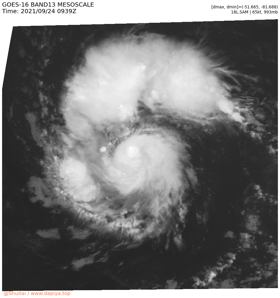
Sam continues to rapidly intensify.  Satellite images show a small,
but well-developed inner core and pronounced curved bands that wrap
most of the way around the center.  There are some dry slots,
however, between the core and bands.  The latest satellite intensity
estimates range from 55 to 77 kt, and based on that data and the
continued improvement in the cyclone's structure, the initial wind
speed is increased to 65 kt.  This makes Sam a hurricane, the
seventh one of the 2021 Atlantic hurricane season. It should be
noted that Sam has a compact wind field, with hurricane-force and
tropical-storm-force winds estimated to only extend outward up to 15
and 50 n mi from the center, respectively.

Sam is moving westward at about 13 kt, and this general motion
should continue for another 12 to 24 hours as it moves in the flow
on the south side of a mid-level ridge.  After that time, a decrease
in forward speed and a turn to the west-northwest are expected, and
the official forecast has Sam moving at a slow pace of only 6-8 kt
during the 48-96-hour time period.  By the middle of next week, the
ridge is forecast to slide eastward as a trough moves over the
western Atlantic. In response, the hurricane will likely turn
northwestward as it approaches the northern Leeward Islands.  The
models have changed little this cycle with the GFS still on the
northern side of the guidance envelope and the ECMWF on the
southern side.  The NHC track forecast is essentially an update of
the previous one and lies between the GFS and ECMWF models, and near
the consensus aids.

The large scale environmental conditions all appear favorable for
continued rapid intensification during the next day or so as the
hurricane is expected to remain over warm 29 deg C waters and in
very low wind shear conditions.  All of the SHIPS rapid
intensification indices are well above the climatological means, and
the NHC intensity forecast calls for Sam to become a major hurricane
by early Saturday.  Beyond a couple of days, the environment is
likely to become a little less ideal, and most of the models show
Sam leveling off in strength, and so does the official forecast.
This intensity prediction lies near a blend of the FSSE, HCCA, and
IVCN consensus models.  Regardless of the details, Sam is expected
to be a significant hurricane during the next several days.


FORECAST POSITIONS AND MAX WINDS

INIT  24/0900Z 11.5N  42.2W   65 KT  75 MPH
12H  24/1800Z 11.7N  44.0W   80 KT  90 MPH
24H  25/0600Z 12.1N  45.9W   95 KT 110 MPH
36H  25/1800Z 12.5N  47.4W  105 KT 120 MPH
48H  26/0600Z 12.9N  48.7W  115 KT 130 MPH
60H  26/1800Z 13.4N  50.0W  115 KT 130 MPH
72H  27/0600Z 14.1N  51.1W  110 KT 125 MPH
96H  28/0600Z 15.9N  53.8W  110 KT 125 MPH
120H  29/0600Z 17.8N  56.6W  110 KT 125 MPH

$$
Forecaster Cangialosi
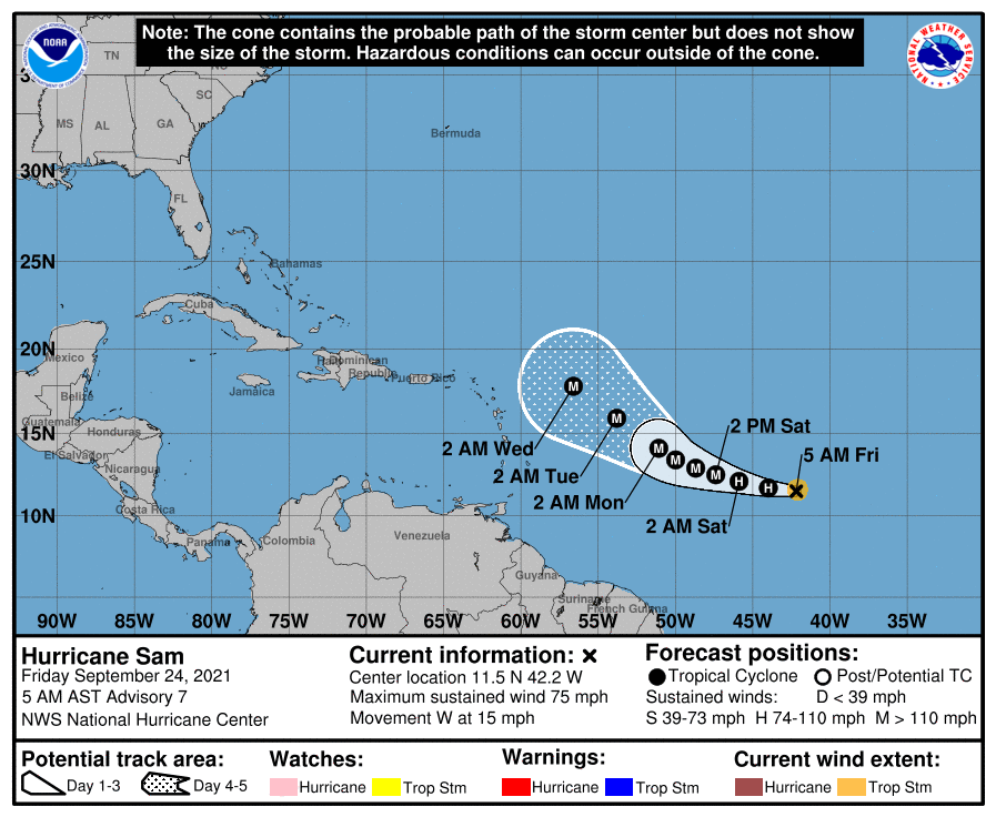
083327_5day_cone_no_line_and_wind.png
18L_BAND13.png
回復

使用道具 舉報

簽到天數: 3206 天

[LV.Master]伴壇終老

king111807|2021-9-25 11:08 | 顯示全部樓層
NHC升格C2
444
WTNT43 KNHC 250234
TCDAT3

Hurricane Sam Discussion Number  10
NWS National Hurricane Center Miami FL       AL182021
1100 PM AST Fri Sep 24 2021

Sam developed a 10-n mi wide eye in infrared satellite images a
few hours ago, surrounded by a ring of cloud tops as cold as about
-70 degrees Celsius.  The core of the hurricane remains compact.  
In fact, recent Synthetic Aperture Radar (SAR) data indicated that
the radius of maximum winds is only about 6 n mi.  Dvorak estimates
were T5.0/90 kt from TAFB and T4.5/77 kt from SAB at 0000 UTC, and
given the additional clearing of the eye since then, Sam's intensity
is raised to 85 kt.

Sam has been moving toward the west-northwest during the past 6 to
12 hours with a motion of 285/12 kt.  The track forecast reasoning
remains the same, and the model guidance is packed more tightly
than normal through day 5.  A blocking ridge lying to the north and
northwest is expected to cause Sam to slow down over the weekend
and maintain a motion toward the west or west-northwest.  On days 3
through 5, the ridge is expected to shift eastward, with a
deep-layer trough developing over the western Atlantic.  This
should allow Sam to turn northwestward toward the end of the
forecast period.  The NHC track forecast has not budged much and
remains close to the TVCA consensus aid.  Based on this forecast,
and nearly all of the reliable guidance, Sam is expected to still
be well to the east or northeast of the northern Leeward Islands
through day 5.

Deep-layer shear is expected to be less than 10 kt for the next day
or two, and Sam will be heading toward waters of higher oceanic
heat content.  These conditions favor continued strengthening, and
the hurricane is forecast to become a major hurricane on Saturday
and possibly reach a peak intensity in 2 to 3 days.  For this
period, the NHC forecast is close to the HCCA consensus aid and
is near the high end of the guidance envelope.  As is usually the
case with hurricanes this small and strong, fluctuations in
intensity due to eyewall replacement cycles will be possible.  On
days 3 through 5, some increase in shear as Sam approaches the
deep-layer western Atlantic trough is possible, and modest weakening
is shown at those times.  


FORECAST POSITIONS AND MAX WINDS

INIT  25/0300Z 12.4N  45.9W   85 KT 100 MPH
12H  25/1200Z 12.7N  47.4W  100 KT 115 MPH
24H  26/0000Z 13.1N  48.8W  110 KT 125 MPH
36H  26/1200Z 13.5N  50.0W  115 KT 130 MPH
48H  27/0000Z 14.1N  51.2W  120 KT 140 MPH
60H  27/1200Z 14.8N  52.4W  120 KT 140 MPH
72H  28/0000Z 15.7N  53.5W  115 KT 130 MPH
96H  29/0000Z 17.4N  55.8W  110 KT 125 MPH
120H  30/0000Z 19.5N  58.8W  110 KT 125 MPH

$$
Forecaster Berg
023606_5day_cone_no_line_and_wind.png
18L_BAND01.png
回復

使用道具 舉報

簽到天數: 3206 天

[LV.Master]伴壇終老

king111807|2021-9-25 23:05 | 顯示全部樓層
NHC升格MH
000
WTNT43 KNHC 251441
TCDAT3

Hurricane Sam Discussion Number  12
NWS National Hurricane Center Miami FL       AL182021
1100 AM AST Sat Sep 25 2021

Sam has continued to intensify this morning and now has a complete
ring of deep convection with cloud tops colder than -70 degrees C
surrounding a mostly clear, small eye. The latest subjective Dvorak
intensity estimates from TAFB and SAB are both 102 kt, while the
combined objective Dvorak intensity estimates from the UW-CIMSS
SATCON and ADT is 110 kt. Based on this data, the initial intensity
has been increased to 105 kt for this advisory, making Sam a major
hurricane. The cyclone remains compact, with hurricane-force winds
extending only 20 n mi from the center.

The hurricane wobbled to the west over the past few hours. However,
the 12-hour motion is west-northwest at 9 kt. There are no changes
to the forecast track reasoning. The ridge the north of Sam
responsible for its current motion is forecast to shift to the east
in a couple of days as a deep-layer trough establishes itself over
the western Atlantic. Sam is forecast to turn northwestward around
the southwestern periphery of the ridge in about 48 h, and gradually
increase its forward speed thereafter. The model guidance continues
to be in very good agreement with this scenario, and the latest NHC
track forecast is unchanged from the previous one. It should be
noted that the westernmost guidance continues to be the ECMWF
ensemble mean, whose members have had a low bias in the intensity of
Sam, which is likely contributing to the westward track bias. Based
on the NHC forecast, and all of the other guidance, Sam is expected
to still be well to the east or northeast of the northern Leeward
Islands through day 5.  

Environmental conditions support further strengthening in the short
term, and Sam is expected to become a category 4 hurricane by
Sunday. In a few days, some southwesterly shear is forecast to
develop as the cyclone begins to round the periphery of the
subtropical ridge. Although this should cause Sam to weaken, it is
still expected to remain a powerful hurricane throughout the 5-day
forecast period. The latest NHC intensity forecast is near the
previous one, which remains slightly above the various consensus
solutions through 72 h, and then closely follows the consensus
thereafter.


FORECAST POSITIONS AND MAX WINDS

INIT  25/1500Z 12.9N  47.6W  105 KT 120 MPH
12H  26/0000Z 13.3N  48.7W  110 KT 125 MPH
24H  26/1200Z 13.7N  49.8W  115 KT 130 MPH
36H  27/0000Z 14.3N  50.8W  120 KT 140 MPH
48H  27/1200Z 15.0N  51.9W  120 KT 140 MPH
60H  28/0000Z 15.8N  53.0W  115 KT 130 MPH
72H  28/1200Z 16.6N  54.1W  115 KT 130 MPH
96H  29/1200Z 18.4N  56.5W  110 KT 125 MPH
120H  30/1200Z 20.7N  59.8W  110 KT 125 MPH

$$
Forecaster Latto
144215_5day_cone_no_line_and_wind.png
18L_BAND01.png
回復

使用道具 舉報

簽到天數: 3206 天

[LV.Master]伴壇終老

king111807|2021-9-26 06:54 | 顯示全部樓層
NHC升格C4
000
WTNT43 KNHC 252039
TCDAT3

Hurricane Sam Discussion Number  13
NWS National Hurricane Center Miami FL       AL182021
500 PM AST Sat Sep 25 2021

After a brief hiccup, Sam has resumed rapid strengthening and now
shows a 12-15 n mi wide well-defined eye embedded in a central
dense overcast with cloud tops colder than -70C. Subjective
satellite intensity estimates from TAFB and SAB were 115 kt at 18Z,
and objective intensity estimates have also been near 115 kt.  
Since the organization has increased some since 18Z, the initial
intensity is increased to 120 kt.  A NOAA Hurricane Hunter aircraft
is currently enroute to Sam to provide a better estimate of the
intensity.  The hurricane has good cirrus outflow in all quadrants.
However, a large arc cloud to the northwest of the central core
suggests dry air is present in that area.

The initial motion is still west-northwestward or 290/9.  There are
again no changes to the forecast track reasoning.  The weak
subtropical ridge currently to the north of Sam is forecast to shift
eastward as a large deep-layer mid-latitude trough develops over the
western Atlantic.  This evolution should cause Sam to continue
west-northwestward with some decrease in forward speed during the
next couple of days, followed by a turn toward the northwest.  Some
increase in forward speed is likely by 120 h as Sam encounters
stronger steering flow.  The track guidance has shifted a little to
the north and east since the previous advisory, and the new forecast
track is also nudged in that direction, with the new track lying
between the HCCA corrected consensus model and the other consensus
models.  Based on the NHC forecast, and all of the other guidance,
Sam is expected to still be well to the east or northeast of the
northern Leeward Islands through day 5.

The current strengthening is expected to continue for the next
6-12 h, and based on this the new intensity forecast now calls for a
peak intensity of 130 kt.  After the peak, Sam is expected to be in
an environment of warm sea surface temperatures and light wind
shear for at least the next 3-4 days.  This suggests the intensity
will be controlled mainly by eyewall replacement cycles and
possible intrusions of dry air, which would cause some short-term
fluctuations in intensity.  In the bigger picture, the intensity
guidance calls for a slow weakening during the 24-120 h forecast
period, and the new intensity forecast does the same.  However, it
is likely that Sam will remain a major hurricane through 120 h.


FORECAST POSITIONS AND MAX WINDS

INIT  25/2100Z 13.3N  48.5W  120 KT 140 MPH
12H  26/0600Z 13.7N  49.4W  130 KT 150 MPH
24H  26/1800Z 14.3N  50.5W  125 KT 145 MPH
36H  27/0600Z 14.9N  51.6W  120 KT 140 MPH
48H  27/1800Z 15.7N  52.7W  120 KT 140 MPH
60H  28/0600Z 16.6N  53.9W  115 KT 130 MPH
72H  28/1800Z 17.4N  55.0W  115 KT 130 MPH
96H  29/1800Z 19.5N  58.0W  110 KT 125 MPH
120H  30/1800Z 22.5N  61.0W  110 KT 125 MPH

$$
Forecaster Beven
204147_5day_cone_no_line_and_wind.png
18L_BAND01.png
18L_BAND13.png
回復

使用道具 舉報

簽到天數: 582 天

[LV.9]以壇為家II

蜜露|2021-9-27 10:28 | 顯示全部樓層
本帖最後由 蜜露 於 2021-9-27 10:32 編輯


令人失望的實測表現  NHC :  維持山姆  Cat.4 130Kts


recon_NOAA2-0218A-SAM (1).png


recon_NOAA2-0218A-SAM_timeseries (1).png


NHC的飛機今天早上終於正面穿心山姆,首次實測了大西洋遠洋的山姆


剛好山姆正面臨置換.


實際風速貌似比官方給的 130Kts更低 只有938 115Kts上下而已

艾達好像是929  130


回復

使用道具 舉報

簽到天數: 582 天

[LV.9]以壇為家II

蜜露|2021-9-28 21:33 | 顯示全部樓層
本帖最後由 蜜露 於 2021-9-28 21:35 編輯


recon_AF307-0718A-SAM (1).png

recon_AF307-0718A-SAM_timeseries (2).png

美國用了AF307 NOAA2 兩架飛機這樣來回的四個象限穿心中心的風眼

山姆颶風的強度有稍微回升到Cat.4的強度  954hPa

巔峰那天是938hPa  強度剛好在置換減弱, 最後估計巔峰約130Kts上下

目前2021年北大西洋的風王還是艾達


說到這點太平洋跟印度洋一直很少有颱風的實測是真的挺可惜的 尤其是南半球從來沒有
要不然的話,今年全球最強的目前是璨樹 實力是今年唯一上看的頂級


回復

使用道具 舉報

簽到天數: 1650 天

[LV.Master]伴壇終老

老農民版夜神月|2021-10-3 05:58 | 顯示全部樓層
NHC降格C3
FORECAST POSITIONS AND MAX WINDS

INIT  02/2100Z 35.4N  58.2W  110 KT 125 MPH
12H  03/0600Z 36.8N  56.5W  100 KT 115 MPH
24H  03/1800Z 38.6N  53.6W   95 KT 110 MPH
36H  04/0600Z 40.8N  49.5W   90 KT 105 MPH
48H  04/1800Z 44.7N  44.0W   85 KT 100 MPH
60H  05/0600Z 49.3N  40.2W   75 KT  85 MPH...POST-TROP/EXTRATROP
72H  05/1800Z 51.6N  38.5W   65 KT  75 MPH...POST-TROP/EXTRATROP
96H  06/1800Z 53.0N  32.0W   50 KT  60 MPH...POST-TROP/EXTRATROP
120H  07/1800Z 60.0N  28.0W   40 KT  45 MPH...POST-TROP/EXTRATROP
203948_5day_cone_no_line_and_wind.png al182021 (3).gif
20L_BAND13.png 20L_RBTOP.png
回復

使用道具 舉報

簽到天數: 3206 天

[LV.Master]伴壇終老

king111807|2021-10-3 19:05 | 顯示全部樓層
NHC降格C2
FORECAST POSITIONS AND MAX WINDS

INIT  03/0900Z 37.3N  55.9W   90 KT 105 MPH
12H  03/1800Z 38.6N  53.6W   85 KT 100 MPH
24H  04/0600Z 41.1N  49.4W   75 KT  85 MPH
36H  04/1800Z 44.9N  44.1W   70 KT  80 MPH...POST-TROP/EXTRATROP
48H  05/0600Z 49.5N  40.6W   65 KT  75 MPH...POST-TROP/EXTRATROP
60H  05/1800Z 51.4N  39.0W   60 KT  70 MPH...POST-TROP/EXTRATROP
72H  06/0600Z 52.0N  36.0W   50 KT  60 MPH...POST-TROP/EXTRATROP
96H  07/0600Z 57.0N  26.9W   40 KT  45 MPH...POST-TROP/EXTRATROP
120H  08/0600Z 60.5N  29.5W   35 KT  40 MPH...POST-TROP/EXTRATROP
084748_5day_cone_no_line_and_wind.png
al182021.gif
18L_RBTOP.png
回復

使用道具 舉報

12
快速回覆
您需要登錄後才可以回帖 登錄 | 立即加入

本版積分規則

本平台僅供學術討論之用,預報應以氣象局為準

威普網站虛擬主機贊助公司

臺灣第一個天氣類型社群平台 即時天氣資訊、精準颱風動態

線上客服
FB傳送訊息
廣告行銷
精準行銷 物超所值
官方粉專
發佈 快速回復 返回頂部 返回列表