開啟輔助訪問
 找回密碼
 立即加入

09L.Ida 墨灣猛爆增強 巔峰曾達C4 重創美國已56死

簽到天數: 1650 天

[LV.Master]伴壇終老

老農民版夜神月|2021-8-29 14:52 | 顯示全部樓層
本帖最後由 老農民版夜神月 於 2021-8-29 14:54 編輯

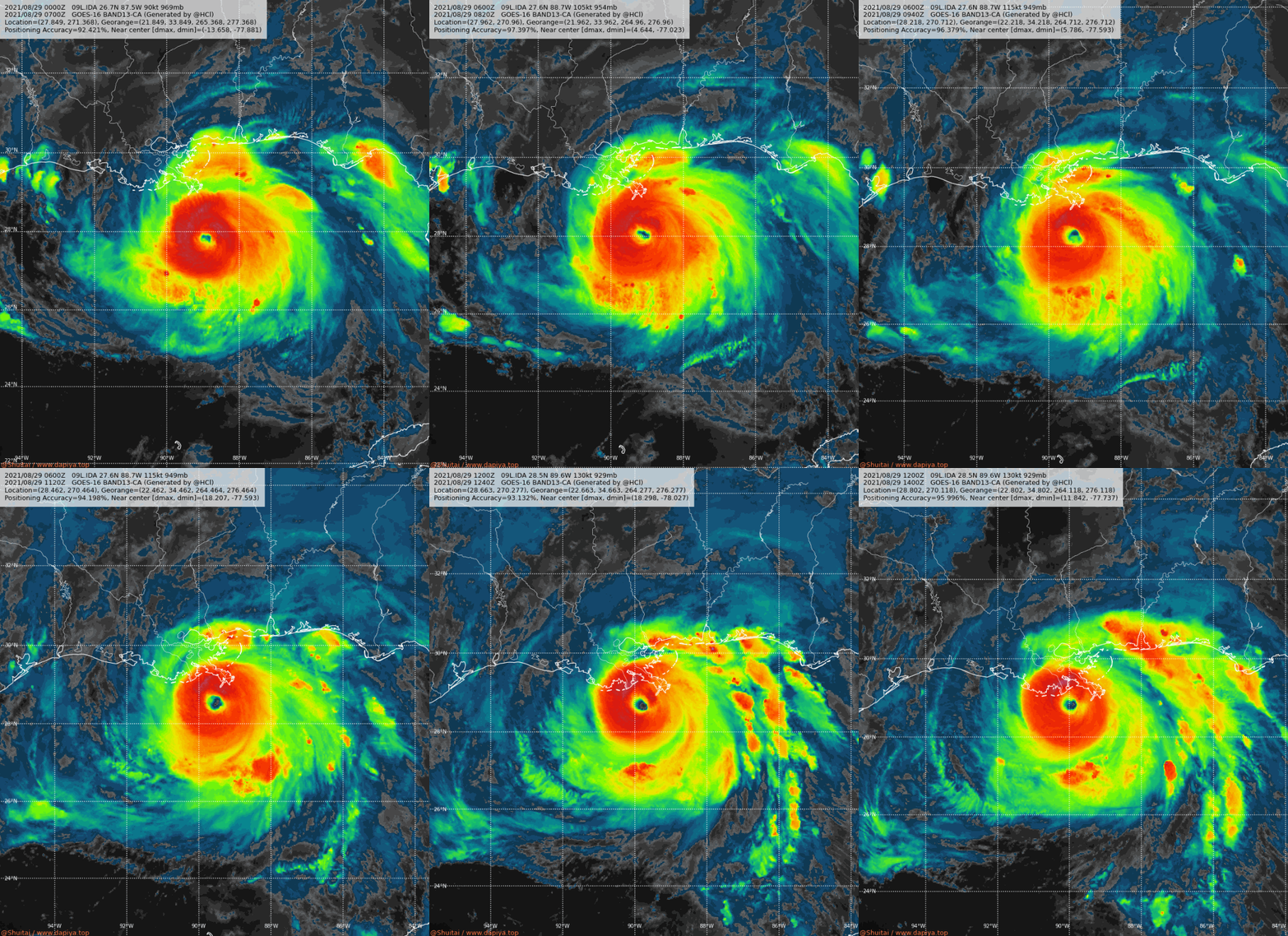
近岸爆發中,NHC07Z再升格C4 09L_BD (1).gif 09L_CA.gif
280
WTNT64 KNHC 290645
TCUAT4

Hurricane Ida Tropical Cyclone Update
NWS National Hurricane Center Miami FL       AL092021
200 AM CDT Sun Aug 29 2021

...MAJOR HURRICANE IDA CONTINUES TO STRENGTHEN...
...NOW A DANGEROUS CATEGORY 4 HURRICANE...

Data from an Air Force Reserve Hurricane Hunter aircraft and NOAA
Doppler weather radars indicate that Hurricane Ida has continued to
rapidly intensify this Sunday morning.  Maximum sustained winds are
now estimated to be 130 mph (215 km/h). This makes Ida a category 4
hurricane on the Saffir-Simpson Hurricane Wind Scale.

Ida's central pressure has fallen 6 millibars during the past hour.

SUMMARY OF 200 AM CDT...0700 UTC...INFORMATION
----------------------------------------------
LOCATION...27.7N 88.8W
ABOUT 100 MI...160 KM S OF THE MOUTH OF THE MISSISSIPPI RIVER
ABOUT 175 MI...280 KM SE OF HOUMA LOUISIANA
MAXIMUM SUSTAINED WINDS...130 MPH...215 KM/H
PRESENT MOVEMENT...NW OR 320 DEGREES AT 15 MPH...24 KM/H
MINIMUM CENTRAL PRESSURE...949 MB...28.02 INCHES

$$
Forecaster Stewart
回復

使用道具 舉報

簽到天數: 1650 天

[LV.Master]伴壇終老

老農民版夜神月|2021-8-29 19:16 | 顯示全部樓層
NHC11Z:130KT,935MB
000
WTNT64 KNHC 291057
TCUAT4

Hurricane Ida Tropical Cyclone Update
NWS National Hurricane Center Miami FL       AL092021
600 AM CDT Sun Aug 29 2021

...NOAA PLANE FINDS IDA STRONGER...
...EXTREMELY DANGEROUS CATEGORY 4 HURRICANE IDA EXPECTED TO MAKE
LANDFALL IN SOUTHEASTERN LOUISIANA LATER TODAY...

Reports from a NOAA Hurricane Hunter aircraft indicate that maximum
sustained winds have increased to near 150 mph (240 km/h) with
higher gusts.  The latest minimum central pressure estimated from
reconnaissance aircraft data is 935 mb (27.61 in).

An elevated NOAA C-MAN station at Pilot's Station East near
Southwest Pass, Louisiana, recently reported a sustained wind of 82
mph (131 km/h) and a gust to 107 mph (172 km/h).  Another NOAA
elevated C-MAN station at Southwest Pass recently reported a
sustained wind of 77 mph (124 km/h) and a wind gust of 93 mph (150
km/h).


SUMMARY OF 600 AM CDT...1100 UTC...INFORMATION
----------------------------------------------
LOCATION...28.3N 89.4W
ABOUT 75 MI...120 KM SSE OF GRAND ISLE LOUISIANA
ABOUT 60 MI...95 KM SSW OF THE MOUTH OF THE MISSISSIPPI RIVER
MAXIMUM SUSTAINED WINDS...150 MPH...240 KM/H
PRESENT MOVEMENT...NW OR 315 DEGREES AT 15 MPH...24 KM/H
MINIMUM CENTRAL PRESSURE...935 MB...27.61 INCHES

$$
Forecaster Brown/Brennan
20210829.0751.gw1.89pct89h89v.09L.IDA.115kts.949mb.27.6N.88.7W.91pc.jpg 20210829.0751.gw1.89hbt.09L.IDA.115kts.949mb.27.6N.88.7W.91pc.jpg 20210829.0751.gw1.89hw.09L.IDA.115kts.949mb.27.6N.88.7W.91pc.jpg
回復

使用道具 舉報

簽到天數: 1650 天

[LV.Master]伴壇終老

老農民版夜神月|2021-8-29 20:36 | 顯示全部樓層
NHC12Z加報認為於登陸前有一定機會達C5強度 09L_BAND01 (2).gif 09L_BD.gif 20210829.1033.f16.91pct91h91v.09L.IDA.115kts.949mb.27.6N.88.7W.090pc.jpg

000
WTNT44 KNHC 291158
TCDAT4

Hurricane Ida Special Discussion Number  13
NWS National Hurricane Center Miami FL       AL092021
700 AM CDT Sun Aug 29 2021

Recent reports from both NOAA and Air Force Reserve Hurricane Hunter
aircraft indicate that Ida has continued to strengthen since the
0900 UTC advisory and the maximum winds are estimated to be 130
kt. This intensity is based on peak 700-mb flight-level winds of
146 kt that have been reported by both aircraft and believable SFMR
winds of around 130 kt. The NOAA aircraft very recently reported
that the minimum pressure has fallen to around 933 mb.  This special
advisory is issued to raise the 12-hour forecast intensity to 135
kt, but it is possible that Ida could peak slightly above that
before landfall occurs.

The initial motion estimate is 320/13 kt, slightly faster than
the previous forecast.  Therefore, the 12-hour forecast point has
also been adjusted slightly.  No other changes were made to the
track or intensity forecasts.

The initial and forecast 64-kt wind radii were adjusted outward in
the northeast and southeast quadrants based on aircraft data.

Note that this Special advisory replaces the regular 1200 UTC (700
AM CDT) intermediate public advisory.

Key Messages:

1. Extremely life-threatening storm surge inundation of 9 feet or
greater above ground level is imminent somewhere within the area
from Burns Point, Louisiana, to Ocean Springs, Mississippi.
Overtopping of local levees outside of the Hurricane and Storm
Damage Risk Reduction System is possible where local inundation
values may be higher. Interests throughout the Storm Surge Warning
area should follow any advice given by local officials.

2. Catastrophic wind damage is likely where the core of Ida moves
onshore along the southeast coast of Louisiana in the next few
hours. Hurricane-force winds are expected today within the Hurricane
Warning area along the Louisiana coast, including metropolitan New
Orleans.

3. Damaging winds, especially in gusts, will spread inland near the
track of the center of Ida across portions of southeastern Louisiana
and southwestern Mississippi today through early Monday. These winds
will likely lead to widespread tree damage and power outages.

4. Ida will produce heavy rainfall today through Monday across the
central Gulf Coast from southeastern Louisiana, coastal Mississippi,
to far southwestern Alabama resulting in considerable to life-
threatening flash and urban flooding and significant river flooding
impacts. As Ida moves inland, significant flooding impacts are
possible across portions of the Lower Mississippi, Tennessee, and
Ohio Valleys through Wednesday.

FORECAST POSITIONS AND MAX WINDS

INIT  29/1200Z 28.5N  89.6W  130 KT 150 MPH
12H  29/1800Z 29.2N  90.4W  135 KT 155 MPH
24H  30/0600Z 30.6N  91.1W   70 KT  80 MPH...INLAND
36H  30/1800Z 32.2N  91.0W   45 KT  50 MPH...INLAND
48H  31/0600Z 33.8N  90.0W   30 KT  35 MPH...INLAND
60H  31/1800Z 35.4N  87.9W   25 KT  30 MPH...INLAND
72H  01/0600Z 36.7N  85.2W   20 KT  25 MPH...INLAND
96H  02/0600Z 38.9N  78.9W   20 KT  25 MPH...POST-TROP/INLAND
120H  03/0600Z...DISSIPATED

$$
Forecaster Brown/Brennan
回復

使用道具 舉報

簽到天數: 3291 天

[LV.Master]伴壇終老

t02436|2021-8-29 23:15 | 顯示全部樓層
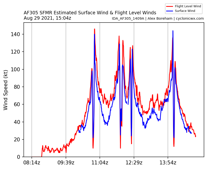
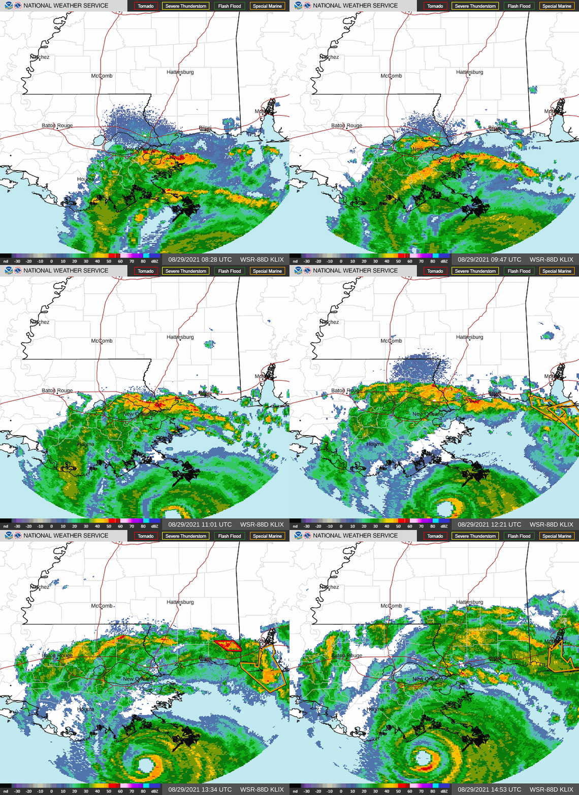
15Z正報維持130節強度。
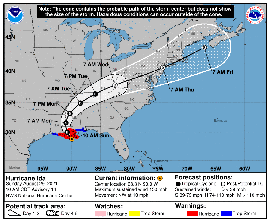
093339_5day_cone_with_line.png
167
WTNT44 KNHC 291456
TCDAT4

Hurricane Ida Discussion Number  14
NWS National Hurricane Center Miami FL       AL092021
1000 AM CDT Sun Aug 29 2021

Ida's rapid strengthening appears to have leveled off within the
past hour or so.  NOAA and Air Force Reserve Hurricane Hunter
aircraft that have been in the storm this morning have reported
peak flight-level winds of 146 to 148 kt between 8000 and
10000 ft, and believable SFMR winds around 130 kt.  Based on
these observations, the initial wind speed remains 130 kt for this
advisory. The central pressure appears to have bottomed out around  
929 mb, and the latest dropsonde in the eye from the Air Force
plane supports a minimum pressure of 933 mb.  Ida's satellite and
radar presentation is very impressive, as the 15-nm-wide eye is
very well-defined and surrounded by a ring of intense convection.  
Within the past hour or so, there is evidence in radar imagery of a
secondary eyewall, and this has likely caused Ida's intensity to
level off for now.  Although Ida's extreme winds are confined to the
inner eyewall, the aircraft data indicate that hurricane-force winds
extend outward about 45 n mi to the northeast of the center, and
based on buoy data the tropical-storm-force wind field extends
outward about 130 n mi northeast of the center.

Ida's eyewall is nearing the coast of Louisiana, and any additional
strengthening seems less likely now given the recent structural
changes of the inner core.  While rapid weakening should occur after
landfall, damaging winds will penetrate well inland across
southeastern Louisiana and southwestern Mississippi through tonight.
Ida is forecast to weaken to a tropical depression over Mississippi
by late Tuesday.  The global model guidance now indicates that Ida
will likely transition to an extratropical low when it nears the
east coast of the United States and the new forecast shows the
extratropical low becoming a gale center near Atlantic Canada at day
5.

Ida has begun to slow down according to the latest aircraft and
radar fixes, and the initial motion estimate is 320/11 kt.  Ida's
forward speed is likely to slow further during the next 12 to 24
hours as the hurricane turns north-northwestward, and then
northward around the western periphery of a deep-layer ridge near
the southeastern United States coast.  The cyclone is predicted to
turn northeastward by late Tuesday ahead of a short-wave trough
that will move across the central United States.  The new NHC track
is close to the HCCA corrected consensus and the GFS ensemble mean,
and is not very different from the previous advisory.

Key Messages:

1. Extremely life-threatening storm surge inundation of 9 feet or
greater above ground level is imminent somewhere within the area
from Burns Point, Louisiana, to Ocean Springs, Mississippi.
Overtopping of local levees outside of the Hurricane and Storm
Damage Risk Reduction System is possible where local inundation
values may be higher.

2. Catastrophic wind damage will occur where the core of Ida moves
onshore along the southeast coast of Louisiana in the next few
hours. Hurricane-force winds and damaging wind gusts are expected
today within the Hurricane Warning in southeastern Louisiana,
including metropolitan New Orleans.

3. Damaging winds, especially in gusts, will spread inland near the
track of the center of Ida into southwestern Mississippi tonight
and early Monday. These winds will likely lead to widespread tree
damage and power outages.

4. Ida will continue to produce heavy rainfall today through Monday
across the central Gulf Coast from southeast Louisiana, coastal
Mississippi, and far southwestern Alabama, resulting in considerable
to life-threatening flash and urban flooding and significant river
flooding impacts. As Ida moves inland, significant flooding impacts
are possible across portions of the Lower Mississippi, Tennessee
Valley, Upper Ohio Valley, Central Appalachians and the Mid-Atlantic
through Wednesday.

FORECAST POSITIONS AND MAX WINDS

INIT  29/1500Z 28.8N  90.0W  130 KT 150 MPH
12H  30/0000Z 30.0N  90.8W   90 KT 105 MPH...INLAND
24H  30/1200Z 31.6N  91.0W   50 KT  60 MPH...INLAND
36H  31/0000Z 33.2N  90.3W   30 KT  35 MPH...INLAND
48H  31/1200Z 34.9N  88.5W   25 KT  30 MPH...INLAND
60H  01/0000Z 36.4N  85.9W   20 KT  25 MPH...INLAND
72H  01/1200Z 37.8N  82.5W   20 KT  25 MPH...POST-TROP/INLAND
96H  02/1200Z 40.5N  74.2W   30 KT  35 MPH...POST-TROP/EXTRATROP
120H  03/1200Z 43.5N  67.0W   35 KT  40 MPH...POST-TROP/EXTRATROP

$$
Forecaster Brown
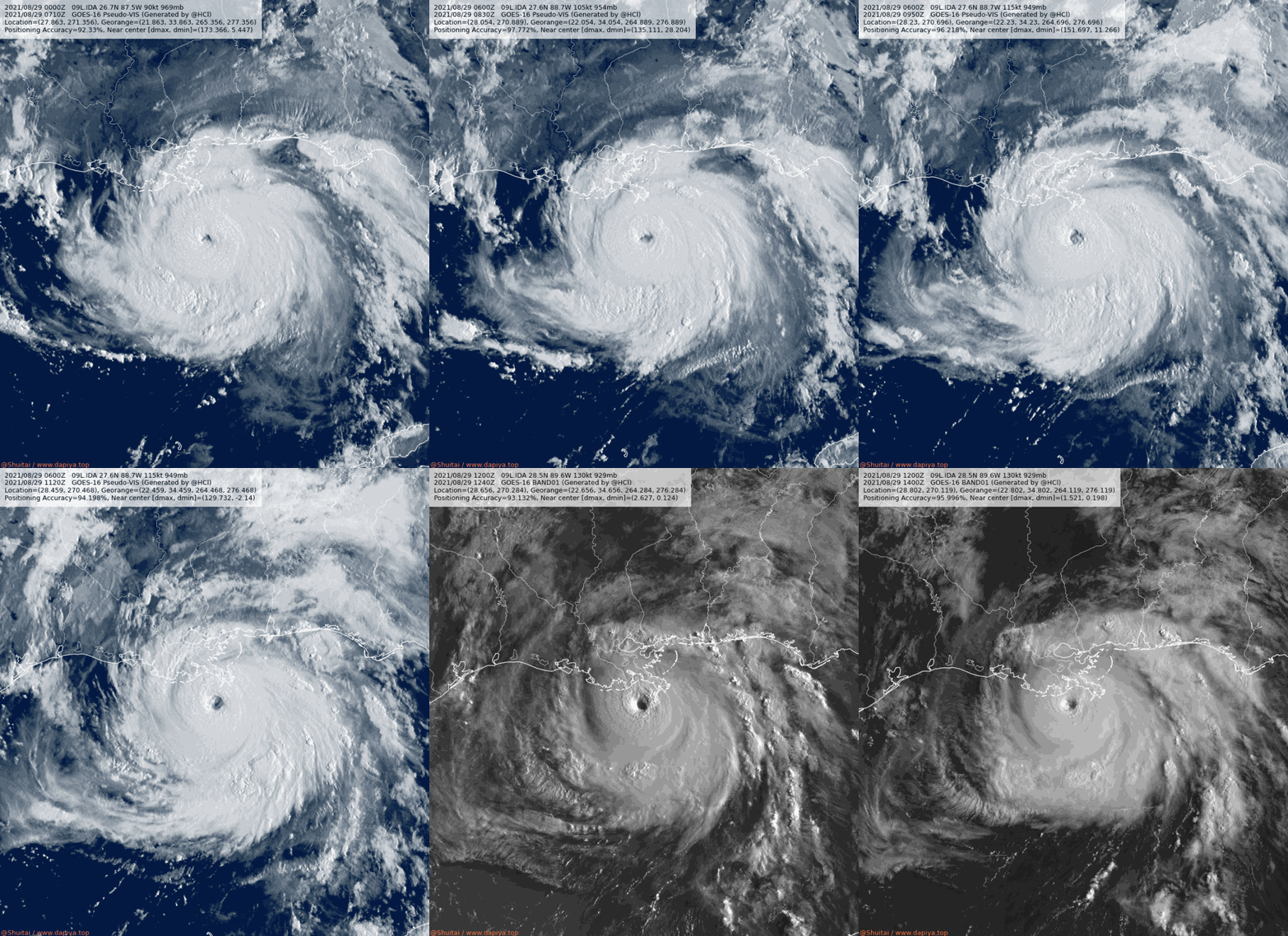
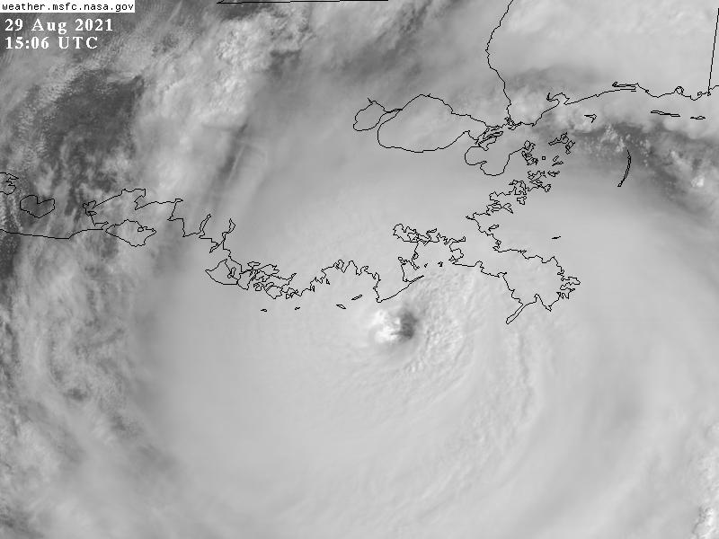
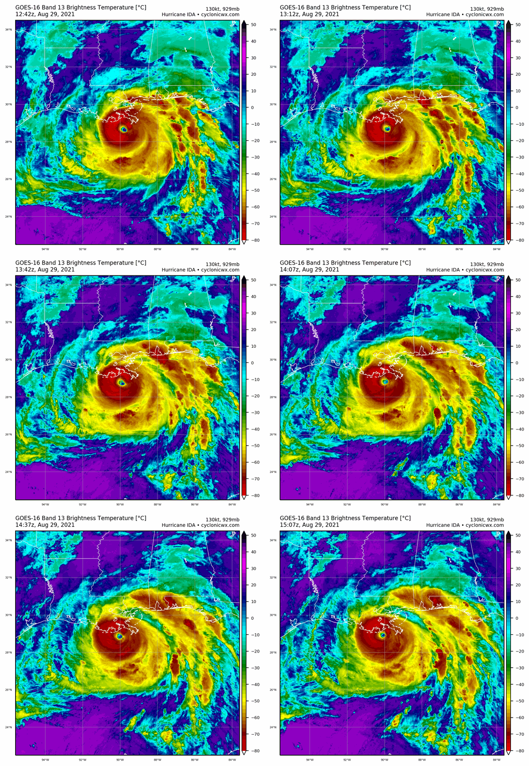
09L_BAND01.gif

09L_CA.gif

GOES15062021241GItFWa.jpg

goes16_rainbow_09L.gif

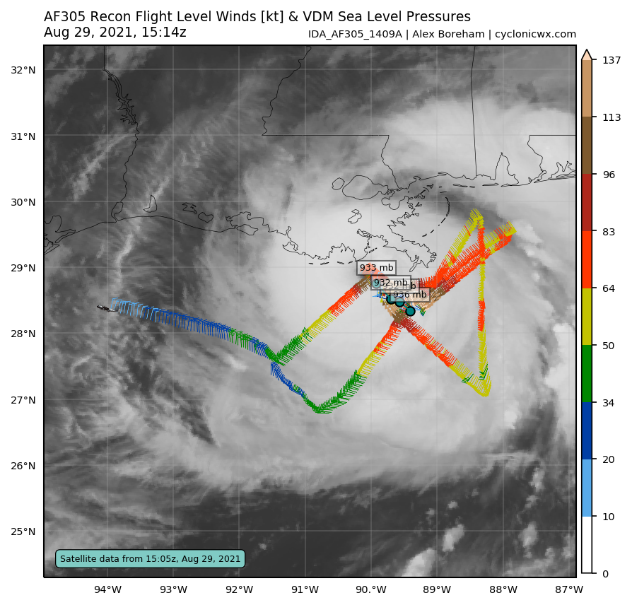
IDA_AF305_1409A_full.png

IDA_AF305_1409A_wind_full.png
Ida_29Aug21_KLIX.gif
回復

使用道具 舉報

簽到天數: 3291 天

[LV.Master]伴壇終老

t02436|2021-8-30 00:40 | 顯示全部樓層
約1545Z進行的穿心實測強度僅120節,16Z更新報維持130節評價,即將在一小時內登陸。
469
WTNT64 KNHC 291557
TCUAT4

Hurricane Ida Tropical Cyclone Update
NWS National Hurricane Center Miami FL       AL092021
1100 AM CDT Sun Aug 29 2021

...1100 AM CDT POSITION UPDATE...
...NORTHERN EYEWALL OF IDA MOVING ONSHORE ALONG THE COAST OF  
SOUTHEASTERN LOUISIANA...

An elevated NOAA C-MAN station at Southwest Pass, Louisiana,  
recently reported a sustained wind of 89 mph (143 km/h) and a wind
gust of 104 mph (167 km/h).

Within the past hour, sustained winds of 44 mph (70 km/h) and a
gust to 60 mph (96 km/h) was reported at Lakefront Airport in New
Orleans.

A NOAA National Ocean Service tide gauge in Shell Beach, Louisiana,
recently reported a water level of 6.0 feet above mean higher high
water, which is an approximation of inundation in that area.

A NOAA National Ocean Service tide gauge at Bay Waveland Yatcht
Club, Mississippi, recently reported a water level of 5.4 feet
above mean higher high water, which is an approximation of
inundation in that area.

SUMMARY OF 1100 AM CDT...1600 UTC...INFORMATION
-----------------------------------------------
LOCATION...28.9N 90.1W
ABOUT 25 MI...40 KM SSW OF GRAND ISLE LOUISIANA
ABOUT 60 MI...95 KM SE OF HOUMA LOUISIANA
MAXIMUM SUSTAINED WINDS...150 MPH...240 KM/H
PRESENT MOVEMENT...NW OR 320 DEGREES AT 13 MPH...20 KM/H
MINIMUM CENTRAL PRESSURE...933 MB...27.55 INCHES

$$
Forecaster Brown/Brennan

IDA_AF303_1509A_full.png

IDA_AF303_1509A_wind_full.png

IDA_AF303_1509A_vdm_202108291601.png

GOES16362021241nvApcS.jpg
回復

使用道具 舉報

簽到天數: 1650 天

[LV.Master]伴壇終老

老農民版夜神月|2021-8-30 01:03 | 顯示全部樓層
本帖最後由 老農民版夜神月 於 2021-8-30 01:07 編輯

NHC判定於1655Z左右已130KT強度登陸路易斯安那州
000
WTNT64 KNHC 291653
TCUAT4

Hurricane Ida Tropical Cyclone Update
NWS National Hurricane Center Miami FL       AL092021
1155 AM CDT Sun Aug 29 2021

...EXTREMELY DANGEROUS CATEGORY 4 HURRICANE IDA MAKES LANDFALL NEAR
PORT FOURCHON LOUISIANA...

NOAA Doppler radar imagery indicates that the eye of Ida made
landfall along the southeastern coast of Louisiana near Port
Fourchon around 1155 AM CDT (1655 UTC).  Data from an Air Force
Reserve reconnaissance aircraft and Doppler radar data indicate that
Ida's maximum sustained winds at landfall were estimated to be 150
mph (240 km/h).  The latest minimum central pressure estimated from
reconnaissance aircraft data is 930 mb (27.46 in).

Within the past hour, sustained winds of 43 mph (69 km/h) and a
gust to 67 mph (107 km/h) were reported at Lakefront Airport in New
Orleans.

A NOAA National Ocean Service tide gauge in Shell Beach, Louisiana,
recently reported a water level of 6.4 feet above mean higher high
water, which is an approximation of inundation in that area.

A NOAA National Ocean Service tide gauge at Bay Waveland Yacht Club,
Mississippi, recently reported a water level of 5.5 feet above mean
higher high water, which is an approximation of inundation in that
area.


SUMMARY OF 1155 AM CDT...1655 UTC...INFORMATION
-----------------------------------------------
LOCATION...29.1N 90.2W
ABOUT 15 MI...25 KM SW OF GRAND ISLE LOUISIANA
ABOUT 45 MI...75 KM SE OF HOUMA LOUISIANA
MAXIMUM SUSTAINED WINDS...150 MPH...240 KM/H
PRESENT MOVEMENT...NW OR 320 DEGREES AT 13 MPH...20 KM/H
MINIMUM CENTRAL PRESSURE...930 MB...27.46 INCHES

$$
Forecaster Brown/Brennan
09L_BAND01 (3).gif goes16_rainbow_09L.gif 09L_BD (1).gif 09L_RBTOP (1).gif
回復

使用道具 舉報

簽到天數: 12 天

[LV.3]偶爾看看II

星風年糕|2021-8-30 03:13 | 顯示全部樓層
185020  6.6  930.1 129.6  6.3 6.3 6.3
Severe Weather Update - YouTube
Hurricane Ida Intercept | August 29, 2021| Lockport, LA - YouTube
還沒睡的可以看個直播


KLIX20210829180737.png
回復

使用道具 舉報

簽到天數: 1650 天

[LV.Master]伴壇終老

老農民版夜神月|2021-8-30 07:14 | 顯示全部樓層
逐漸深入內陸,NHC降格C3 09L_BAND01 (4).gif goes16_ir_09L.gif 09L_BD (2).gif 09L_RBTOP (2).gif


000
WTNT64 KNHC 292257
TCUAT4

Hurricane Ida Tropical Cyclone Update
NWS National Hurricane Center Miami FL       AL092021
600 PM CDT Sun Aug 29 2021

...IDA PASSING JUST EAST OF MATHEWS LOUISIANA...
...CATASTROPHIC STORM SURGE, EXTREME WINDS, AND FLASH FLOODING
CONTINUE IN PORTIONS OF SOUTHEASTERN LOUISIANA...

A Florida Coastal Monitoring Program observing station at the South
Lafourche airport recently reported a sustained wind of 79 mph (125
km/h) and a wind gust of 103 mph (165 km/h).

The New Orleans Lakefront Airport reported a sustained wind of 66
mph (106 km/h) with a wind gust of 84 mph (135 km/h).

Also within the last hour, a Weatherflow site on the Pontchartrain
Causeway reported a sustained wind of 64 mph (103 km/h) and a wind
gust of 81 mph (130 km/h).

An observation in Lockport recently reported a minimum pressure of
941 mb (27.79 inches) inside the eye of Ida.


SUMMARY OF 600 PM CDT...2300 UTC...INFORMATION
----------------------------------------------
LOCATION...29.7N 90.5W
ABOUT 5 MI...10 KM E OF HOUMA LOUISIANA
ABOUT 30 MI...50 KM SW OF NEW ORLEANS LOUISIANA
MAXIMUM SUSTAINED WINDS...125 MPH...200 KM/H
PRESENT MOVEMENT...NW OR 330 DEGREES AT 10 MPH...17 KM/H
MINIMUM CENTRAL PRESSURE...941 MB...27.79 INCHES

$$
Forecaster Latto
回復

使用道具 舉報

快速回覆
您需要登錄後才可以回帖 登錄 | 立即加入

本版積分規則

本平台僅供學術討論之用,預報應以氣象局為準

威普網站虛擬主機贊助公司

臺灣第一個天氣類型社群平台 即時天氣資訊、精準颱風動態

線上客服
FB傳送訊息
廣告行銷
精準行銷 物超所值
官方粉專
發佈 快速回復 返回頂部 返回列表