開啟輔助訪問
 找回密碼
 立即加入

07L.Grace 巔峰曾達C3 登陸墨西哥 進入東太

簽到天數: 3291 天

[LV.Master]伴壇終老

t02436|2021-8-20 23:42 | 顯示全部樓層
近岸爆發,眼牆構建中...15Z根據稍早實測評價75節,樂觀上望以90節巔峰登陸墨西哥。
20210820.1242.f17.91pct91h91v.07L.GRACE.75kts.983mb.20.6N.93.7W.075pc.jpg

144919_5day_cone_with_line.png
ZCZC MIATCDAT2 ALL
TTAA00 KNHC DDHHMM

Hurricane Grace Discussion Number  29
NWS National Hurricane Center Miami FL       AL072021
1000 AM CDT Fri Aug 20 2021

Grace is a strengthening tropical cyclone. Its structure has
continued to improve in satellite imagery this morning, with more
pronounced curved banding in its northern and eastern semicircles
and good upper-level outflow. An Air Force Reserve Hurricane Hunter
aircraft measured a peak 850-mb flight-level wind of 92 kt and peak
SFMR winds of 74 kt during a pass through the northeast quadrant
earlier this morning. These data support increasing the initial
intensity of 75 kt, which makes Grace a hurricane once again.
Dropsonde data from the aircraft indicate the minimum pressure has
fallen to 982 mb.

The warm waters of the Bay of Campeche are expected to support
additional intensification through landfall in mainland Mexico later
this evening or tonight, despite some light to moderate northerly
wind shear. Since the reconnaissance data revealed Grace is
strengthening quicker than previously forecast, the official NHC
intensity forecast was increased in the short-term. Grace is now
forecast to become a 90-kt hurricane in 12 h, which lies on the high
end of the intensity guidance. The center of Grace will be well
inland by 24 h, and rapid weakening is forecast thereafter as the
cyclone moves over the mountains of central Mexico. Although Grace
is forecast to dissipate by 48 h, its remnants will likely move into
the eastern Pacific and lead to the development of a new tropical
cyclone later this weekend or early next week.

The cyclone is moving just south of due west, or 265/12 kt. Grace
should continue moving westward to west-southwestward through
landfall to the south of a mid-level ridge over the northern Gulf of
Mexico. The official NHC track forecast remains near the middle of
the guidance envelope and has been adjusted just a bit southward
based on the latest multi-model consensus aids.

Key Messages:

1. Hurricane conditions and dangerous storm surge are likely along
portions of eastern mainland Mexico beginning late today within the
Hurricane Warning area from Puerto Veracruz northward to Cabo Rojo.

2. Through the weekend, heavy rainfall across Veracruz, Puebla,
Tlaxcala, Hidalgo, northern Queretaro, and eastern San Luis Potosi
will lead to flash and urban flooding, along with the likelihood of
mudslides.

FORECAST POSITIONS AND MAX WINDS

INIT  20/1500Z 20.6N  94.3W   75 KT  85 MPH
12H  21/0000Z 20.4N  95.9W   90 KT 105 MPH
24H  21/1200Z 20.0N  98.2W   55 KT  65 MPH...INLAND
36H  22/0000Z 19.4N 101.1W   35 KT  40 MPH...INLAND
48H  22/1200Z...DISSIPATED

$$
Forecaster Reinhart/Cangialosi

NNNN

GOES15312021232fTGZF9.jpg

goes16_vis_07L.gif


GRACE_AF303_1807A_full.png

GRACE_AF303_1807A_wind_full.png

07L_CA.gif
回復

使用道具 舉報

簽到天數: 1650 天

[LV.Master]伴壇終老

老農民版夜神月|2021-8-21 05:33 | 顯示全部樓層
本帖最後由 老農民版夜神月 於 2021-8-21 05:38 編輯

距離登陸僅剩12小時,NHC持續調升定強為80節,下一報有望C2 goes16_rainbow_07L.gif
20212322050_GOES16-ABI-FL-GEOCOLOR-AL072021-1000x1000.jpg 07L_RBTOP.png
204556_5day_cone_no_line_and_wind.png
000
WTNT42 KNHC 202045
TCDAT2

Hurricane Grace Discussion Number  30
NWS National Hurricane Center Miami FL       AL072021
400 PM CDT Fri Aug 20 2021

The satellite presentation of Grace has greatly improved over the
past several hours. Deep convection has become more concentrated
over the center, and the central dense overcast now appears more
symmetric. Dropsonde winds and peak 850-mb flight level wind  
measured by the Air Force Hurricane Hunters around midday were
consistent with an intensity of around 75 kt. However, the surface
pressure has been gradually falling throughout the day, and recent
satellite data suggest the hurricane is becoming better organized.
Therefore, the initial intensity is raised to 80 kt for this
advisory, which is supported by the latest UW-CIMSS objective ADT
estimate.

Given the high oceanic heat content within the southwestern Gulf of
Mexico, additional strengthening is expected through Grace's
landfall tonight. The 10-15 kt of northerly vertical wind shear over
Grace does not appear to be having much of a negative effect on the
cyclone at this time. Thus, the official NHC intensity forecast
remains on the high end of the guidance envelope, and is closest to
the statistical-dynamical models DSHP and LGEM. The current forecast
shows Grace making landfall within the next 12-18 h. Once the center
of Grace moves inland over the mountains of central Mexico, the
cyclone should rapidly weaken and then dissipate by 48 h. However,
its remnants appear likely to move into the eastern Pacific and lead
to the development of a new tropical cyclone in that basin later
this weekend or early next week.

Earlier reconnaissance data indicate that Grace has slowed down a
bit today, and its initial motion is estimated to be 265/9 kt. This
general motion should continue through landfall as Grace is steered
by a mid-level ridge over the northern Gulf of Mexico. The official
NHC track forecast is slightly slower, but otherwise very similar to
the previous one and lies near the center of the guidance envelope.

Key Messages:

1. Hurricane conditions and dangerous storm surge are likely along
portions of the coast of eastern mainland Mexico beginning this
evening within the Hurricane Warning area from Puerto Veracruz
northward to Cabo Rojo.

2. Through the weekend, heavy rainfall across Veracruz, Puebla,
Tlaxcala, Hidalgo, northern Queretaro, and eastern San Luis Potosi
will lead to significant flash and urban flooding, along with the
likelihood of mudslides.

FORECAST POSITIONS AND MAX WINDS

INIT  20/2100Z 20.5N  95.1W   80 KT  90 MPH
12H  21/0600Z 20.4N  96.6W   90 KT 105 MPH...NEAR THE COAST
24H  21/1800Z 19.9N  98.9W   45 KT  50 MPH...INLAND
36H  22/0600Z 19.5N 101.9W   30 KT  35 MPH...INLAND
48H  22/1800Z...DISSIPATED

$$
Forecaster Reinhart/Cangialosi
回復

使用道具 舉報

簽到天數: 1650 天

[LV.Master]伴壇終老

老農民版夜神月|2021-8-21 08:08 | 顯示全部樓層
NHC升格C2 07L_RBTOP.gif

000
WTNT32 KNHC 210000
TCPAT2

BULLETIN
Hurricane Grace Intermediate Advisory Number 30A
NWS National Hurricane Center Miami FL       AL072021
700 PM CDT Fri Aug 20 2021

...AIR FORCE RECONNAISSANCE AIRCRAFT FINDS GRACE INTENSIFYING...
...LANDFALL ALONG EASTERN MAINLAND MEXICO EXPECTED LATER TONIGHT...


SUMMARY OF 700 PM CDT...0000 UTC...INFORMATION
----------------------------------------------
LOCATION...20.7N 95.7W
ABOUT 105 MI...170 KM E OF TUXPAN MEXICO
ABOUT 105 MI...170 KM NNE OF VERACRUZ MEXICO
MAXIMUM SUSTAINED WINDS...100 MPH...150 KM/H
PRESENT MOVEMENT...W OR 270 DEGREES AT 10 MPH...17 KM/H
MINIMUM CENTRAL PRESSURE...967 MB...28.55 INCHES
000127_5day_cone_no_line_and_wind.png 20210820.2340.goes-16.vis.2km.07L.GRACE.80kts.979mb.20.6N.94.6W.pc.jpg
回復

使用道具 舉報

簽到天數: 1650 天

[LV.Master]伴壇終老

老農民版夜神月|2021-8-21 14:16 | 顯示全部樓層
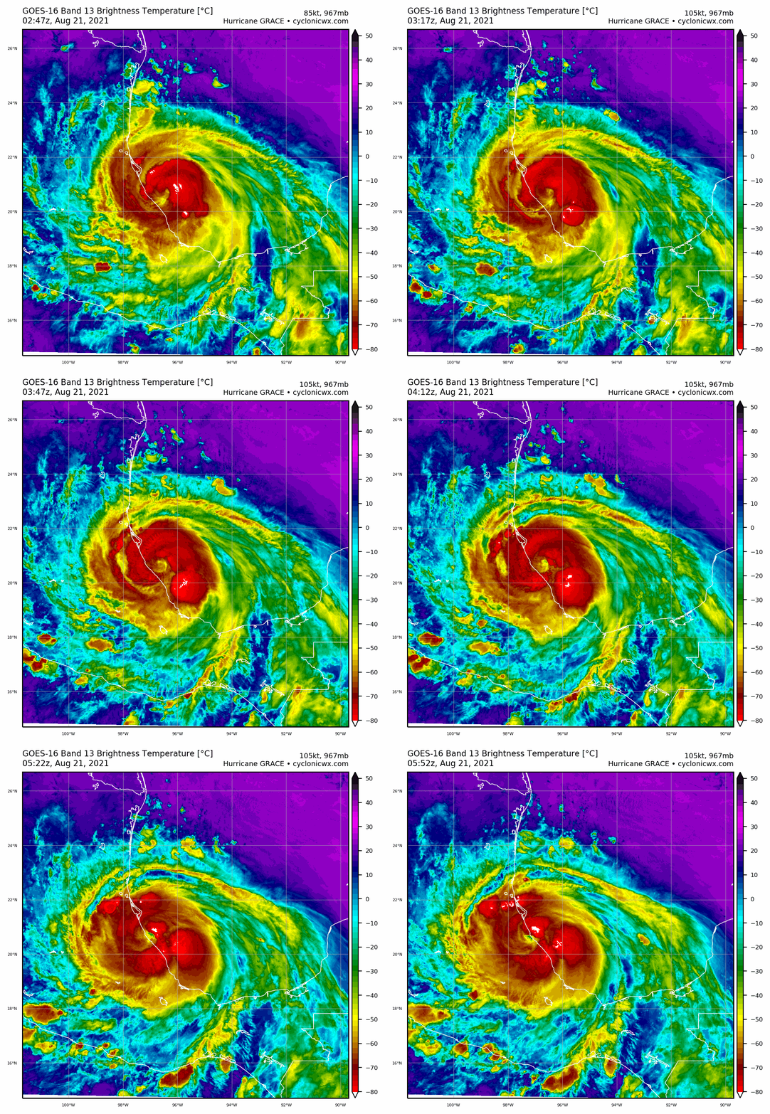
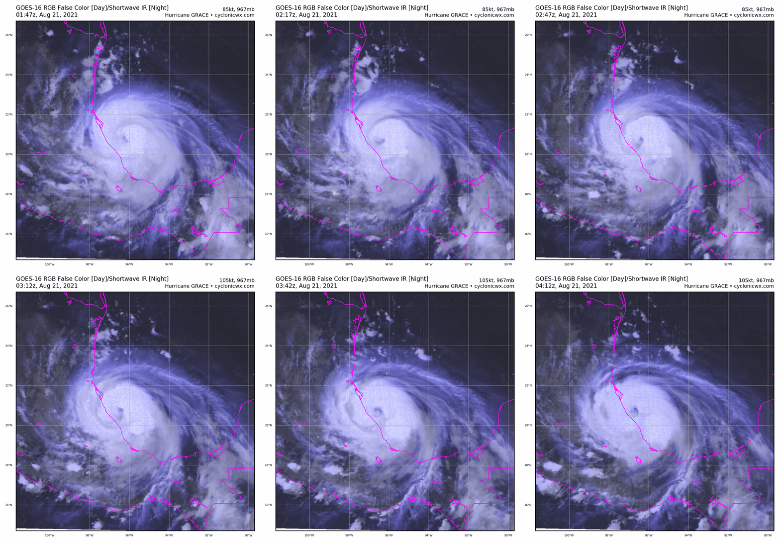
升格MH,登陸在即 goes16_vis_07L.gif goes16_rainbow_07L (1).gif
ZCZC MIATCDAT2 ALL
TTAA00 KNHC DDHHMM

Hurricane Grace Discussion Number  31
NWS National Hurricane Center Miami FL       AL072021
1000 PM CDT Fri Aug 20 2021

Hurricane Grace has rapidly intensified this evening. Deep cold
convection has been wrapping around the center, with some evidence
of mesovorticies rotating within the eyewall following the GOES-16
GLM lightning data. The Air Force Reserve Hurricane Hunters arrived
in Grace around 0000 UTC and found that the storm had intensified
into Category 2 hurricane with the pressure dropping down to
967 mb, which is a pronounced deepening rate of 2 mb per hour
compared to the previous advisory. More recently, the aircraft was
able to pass through the northeastern eyewall, and recently found
flight level winds up to 115 kt with SFMR winds of 105 kt. These
observations support Grace being upgraded to a major hurricane this
advisory, with maximum sustained winds of 105 kt.

Some additional strengthening is possible while Grace remains over
the very warm waters in the Bay of Campeche, though the hurricane
should be making landfall tonight within the next 3-6 hours just
south of Tuxpan, Mexico. By tomorrow morning, the storm should be
well inland, and rapid weakening will likely be underway over the
very mountainous terrain of mainland Mexico. The latest NHC
intensity forecast now had Grace dissipating over Mexico in about
36 hours. However, as discussed in previous advisories, while the
low-level circulation is expected to dissipate, the mid-level vortex
is forecast to survive the passage of Mexico, and this feature is
likely to lead to the development of a new tropical cyclone in the
eastern Pacific basin later this weekend or early next week.

Center fixes from the aircraft indicate that Grace has stayed on a
mostly due westward heading, at 270/9 kt. This general motion,
though with a bit more southward component should continue through
landfall and dissipation. This southward deflection over often
occurs with strong hurricanes in this region, due to the
topographical effects of the wind field to the north ascending over
the higher terrain.  The official NHC track is very similar to the
previous advisory, and remains near the middle of the guidance
consensus.

Key Messages:

1. Hurricane conditions and dangerous storm surge are likely along
portions of the coast of eastern mainland Mexico beginning tonight
and tomorrow morning within the Hurricane Warning area from Puerto
Veracruz northward to Cabo Rojo.

2.  A dangerous storm surge is likely near and to the north of the
where the center of Grace crosses the coast of Mexico.

3. Through the weekend, heavy rainfall across Veracruz, Puebla,
Tlaxcala, Hidalgo, northern Queretaro, and eastern San Luis Potosi
will lead to significant flash and urban flooding, along with the
likelihood of mudslides.


FORECAST POSITIONS AND MAX WINDS

INIT  21/0300Z 20.7N  96.3W  105 KT 120 MPH
12H  21/1200Z 20.3N  97.9W   75 KT  85 MPH...INLAND
24H  22/0000Z 20.0N 100.9W   45 KT  50 MPH...INLAND
36H  22/1200Z...DISSIPATED

$$
Forecaster Papin/Beven

NNNN


回復

使用道具 舉報

簽到天數: 3291 天

[LV.Master]伴壇終老

t02436|2021-8-21 17:07 | 顯示全部樓層
06Z以巔峰205Kph(110Kts)、962hPa登陸墨西哥
085643_5day_cone_with_line.png
ZCZC MIATCPAT2 ALL
TTAA00 KNHC DDHHMM

BULLETIN
Hurricane Grace Intermediate Advisory Number 31A
NWS National Hurricane Center Miami FL       AL072021
100 AM CDT Sat Aug 21 2021

...GRACE STRENGTHENS A LITTLE MORE AS IT MAKES LANDFALL SOUTH OF
TUXPAN MEXICO...


SUMMARY OF 100 AM CDT...0600 UTC...INFORMATION
----------------------------------------------
LOCATION...20.6N 97.2W
ABOUT 30 MI...50 KM SSE OF TUXPAN MEXICO
ABOUT 115 MI...185 KM NNW OF VERACRUZ MEXICO
MAXIMUM SUSTAINED WINDS...125 MPH...205 KM/H
PRESENT MOVEMENT...W OR 265 DEGREES AT 10 MPH...17 KM/H
MINIMUM CENTRAL PRESSURE...962 MB...28.41 INCHES


WATCHES AND WARNINGS
--------------------
CHANGES WITH THIS ADVISORY:

None.

SUMMARY OF WATCHES AND WARNINGS IN EFFECT:

A Hurricane Warning is in effect for...
* The coast of mainland Mexico from Puerto Veracruz to Cabo Rojo

A Tropical Storm Warning is in effect for...
* The coast of mainland Mexico from north of Cabo Rojo to Barra del
Tordo

A Hurricane Warning means that hurricane conditions are expected
somewhere within the warning area.  

A Tropical Storm Warning means that tropical storm conditions are
expected somewhere withing the warning area.

For storm information specific to your area, please monitor
products issued by your national meteorological service.


DISCUSSION AND OUTLOOK
----------------------
Satellite imagery and radar data from Mexico indicate that Grace
has made landfall along the coast of Mexico near Tecolutla, Mexico,
just prior to 100 AM CDT (0600 UTC).
  At 100 AM CDT (0600 UTC), the
center of Hurricane Grace was located just inland near latitude 20.6
North, longitude 97.2 West. Grace is moving toward the west near 10
mph (17 km/h) and this general motion is expected to continue
through this evening. On the forecast track, the center of Grace is
forecast to farther inland over mainland Mexico today.

Maximum sustained winds have increased to near 125 mph (205 km/h)
with higher gusts. Grace is a category 3 hurricane on the
Saffir-Simpson Hurricane Wind Scale.  Rapid weakening is expected
as Grace moves inland over the mountains of central Mexico later
today.

Hurricane-force winds extend outward up to 30 miles (45 km) from
the center and tropical-storm-force winds extend outward up to 150
miles (240 km).

The estimated minimum central pressure is 962 mb (28.41 inches).


HAZARDS AFFECTING LAND
----------------------
Key messages for Grace can be found in the Tropical Cyclone
Discussion under AWIPS header MIATCDAT2, WMO header WTNT42 KNHC and
on the web at www.hurricanes.gov/graphics_at2.shtml?key_messages.

STORM SURGE: A dangerous storm surge will raise water levels by as
much as 6 to 9 ft above normal tide levels along the immediate coast
within the hurricane warning area near and north of where the center
is making landfall through early this morning. Near the coast, the
surge will be accompanied by large and destructive waves.

WIND: Hurricane conditions are expected to continue within portions
of the hurricane warning area in mainland Mexico through early this
morning. Tropical storm conditions are expected to continue within
the tropical storm warning area in mainland Mexico through this
morning.

RAINFALL: Grace is expected to produce the following rainfall
amounts:

Over Veracruz, Puebla, Tlaxcala, Hidalgo, Queretaro, and eastern San
Luis Potosi...6 to 12 inches of rain with isolated maximum totals of
18 inches are expected through Sunday. Heavy rainfall from Grace
will result in significant flash and urban flooding as well as
mudslides.

SURF: High surf generated by Grace will affect the southern Gulf of
Mexico coastline into the weekend. These swells are likely to cause
life-threatening surf and rip current conditions.  Please consult
products from your local weather office.


NEXT ADVISORY
-------------
Next complete advisory at 400 AM CDT.

$$
Forecaster Latto

NNNN

07L_BAND01.gif
goes16_rainbow_07L.gif
回復

使用道具 舉報

簽到天數: 1650 天

[LV.Master]伴壇終老

老農民版夜神月|2021-8-22 00:14 | 顯示全部樓層
NHC展望60%/80%
1. Hurricane Grace, located over eastern Mexico, is forecast to
dissipate over inland Mexico today.  However, Grace's remnants are
expected to continue moving westward and emerge over the eastern
Pacific Ocean off the west-central coast of Mexico by Sunday
afternoon.  Environmental conditions are forecast to be
conducive for development, and a tropical depression is likely to
form by early next week while the system moves westward at 10 to 15
mph away from the coast of Mexico.
* Formation chance through 48 hours...medium...60 percent.
* Formation chance through 5 days...high...80 percent.
two_pac_2d1 (35).png two_pac_5d1 (35).png
07L_BAND01 (1).gif
回復

使用道具 舉報

簽到天數: 1650 天

[LV.Master]伴壇終老

老農民版夜神月|2021-8-22 03:53 | 顯示全部樓層
本帖最後由 老農民版夜神月 於 2021-8-22 03:54 編輯

NHC降格TS
698
WTNT32 KNHC 211733
TCPAT2

BULLETIN
Tropical Storm Grace Intermediate Advisory Number 33A
NWS National Hurricane Center Miami FL       AL072021
100 PM CDT Sat Aug 21 2021

...GRACE CONTINUES WEAKENING RAPIDLY OVER LAND BUT STILL CAUSING
VERY HEAVY RAINS AND FLOODING OVER PORTIONS OF EAST-CENTRAL
MEXICO...


SUMMARY OF 100 PM CDT...1800 UTC...INFORMATION
----------------------------------------------
LOCATION...19.7N 99.5W
ABOUT 35 MI...55 KM NW of CIUDAD DE MEXICO
MAXIMUM SUSTAINED WINDS...45 MPH...75 KM/H
PRESENT MOVEMENT...WSW OR 250 DEGREES AT 13 MPH...20 KM/H
MINIMUM CENTRAL PRESSURE...998 MB...29.47 INCHES

173918_5day_cone_no_line_and_wind.png

於東太平洋的展望則提升至High,70%

two_pac_2d1 (36).png two_pac_5d1 (36).png
07L_tracks_latest.png
回復

使用道具 舉報

簽到天數: 1650 天

[LV.Master]伴壇終老

老農民版夜神月|2021-8-22 10:41 | 顯示全部樓層
NHC21Z判定原中心於墨西哥高原上消散 204524_5day_cone_no_line_and_wind.png 20210821.2100.goes-16.vis.2km.07L.GRACE.40kts.998mb.19.7N.99.5W.pc.jpg

000
WTNT42 KNHC 212045
TCDAT2

Remnants Of Grace Discussion Number  34
NWS National Hurricane Center Miami FL       AL072021
400 PM CDT Sat Aug 21 2021

The mountainous terrain of Mexico has taken its toll on Grace.  
Surface observations and high-resolution visible satellite images
indicate that the system no longer has a definite surface
circulation, and Grace has degenerated into a trough to the
west of Mexico City.  Therefore, this is the last advisory on this
system.

Although the surface center has dissipated, the mid-tropospheric
remnants of Grace are expected to continue westward, and to emerge
into the eastern Pacific Ocean by late Sunday.  There is high
likelihood that this will lead to the formation of a new tropical
cyclone over that basin by early next week.  For additional
information on this possibility, see the eastern North Pacific
Tropical Weather Outlook under AWIPS header MIATWOEP, WMO header
ABPZ20 KNHC and on the web at hurricanes.gov.

Key Messages:

1. Through tonight, lingering heavy rainfall from the remnants of
Grace may result in additional areas of flash and urban flooding,
along with mudslides, over central Mexico.

FORECAST POSITIONS AND MAX WINDS

INIT  21/2100Z 19.6N 100.1W   20 KT  25 MPH...REMNANTS
12H  22/0600Z...DISSIPATED

$$
Forecaster Pasch
回復

使用道具 舉報

快速回覆
您需要登錄後才可以回帖 登錄 | 立即加入

本版積分規則

本平台僅供學術討論之用,預報應以氣象局為準

威普網站虛擬主機贊助公司

臺灣第一個天氣類型社群平台 即時天氣資訊、精準颱風動態

線上客服
FB傳送訊息
廣告行銷
精準行銷 物超所值
官方粉專
發佈 快速回復 返回頂部 返回列表