開啟輔助訪問
 找回密碼
 立即加入

91S

簽到天數: 483 天

[LV.9]以壇為家II

2021-4-7 08:18 來自手機 | 顯示全部樓層
  基本資料     
編號    :91 S
擾動編號日期:2021 04 07 08
撤編日期  :2021 04 11 20
91S.INVEST.15kts-993mb-9S-99.4E

4706E0C2-B1C6-4277-BCC8-078686C37DCC.jpeg

評分

參與人數 1水氣能量 +15 +1 收起 理由
king111807 + 15 + 1 熱帶擾動首帖

查看全部評分

回復

使用道具 舉報

簽到天數: 483 天

[LV.9]以壇為家II

dom|2021-4-7 14:13 | 顯示全部樓層
BoM編號24U, 評級Moderate
Another tropical low (24U) lies well to the northwest of the Cocos (Keeling) Islands. It is expected to move east with little development on Thursday before taking a southeast track from Friday where it may enter the region. The system will continue tracking southeast over the weekend and may pass close to the Cocos (Keeling) Islands while intensifying. There is a moderate chance it develops into a tropical cyclone over the weekend and could be near the Islands. Even if it remains a tropical low, the Cocos (Keeling) Islands may experience increased squally shower and thunderstorm activity during this time with some gusty winds.
Thankfully, there are no other significant systems expected in the region for at least the next three days.

Likelihood of this system being a tropical cyclone in the Western Region on:
Thursday:Very Low
Friday: Low
Saturday:Moderate
5974AA4C-C0CA-462E-A51E-46E18D8C58C1.jpeg
回復

使用道具 舉報

簽到天數: 483 天

[LV.9]以壇為家II

dom|2021-4-7 18:53 | 顯示全部樓層
JTWC評級Low
     (1) AN AREA OF CONVECTION (INVEST 91S) HAS PERSISTED NEAR 9.7S
91.4E, APPROXIMATELY 355 NM NORTHWEST OF COCOS ISLANDS, AUSTRALIA.
ANIMATED MULTISPECTRAL ENHANCED SATELLITE IMAGERY AND A PARTIAL
070706Z AMSR-2 89 GHZ MICROWAVE PASS REVEAL DISORGANIZED BANDING
WITH CYCLING CONVECTION TO THE SOUTH-SOUTHWEST AND EAST OF A BROAD
LOW LEVEL CIRCULATION (LLC). INVEST 91S IS IN A MARGINAL ENVIRONMENT
FOR TROPICAL DEVELOPMENT WITH GOOD POLEWARD OUTFLOW ALOFT AND WARM
(29-30C) SEA SURFACE TEMPERATURES OFFSET BY STRONG (20-25KTS)
VERTICAL WIND SHEAR (VWS). GLOBAL MODELS ARE IN GOOD AGREEMENT THAT
INVEST 91S WILL CONSOLIDATE AND INTENSIFY OVER THE NEXT 24-48 HOURS
AS IT TRACKS TO THE SOUTHEAST UNDER AN AREA OF LOW (10-15KTS) VWS.
MAXIMUM SUSTAINED SURFACE WINDS ARE ESTIMATED AT 18 TO 23 KNOTS.
MINIMUM SEA LEVEL PRESSURE IS ESTIMATED TO BE NEAR 1007 MB. THE
POTENTIAL FOR THE DEVELOPMENT OF A SIGNIFICANT TROPICAL CYCLONE
WITHIN THE NEXT 24 HOURS IS UPGRADED TO LOW.
7B796301-6F90-4B23-8AF0-07C9D9F5519C.jpeg
回復

使用道具 舉報

簽到天數: 1650 天

[LV.Master]伴壇終老

老農民版夜神月|2021-4-8 01:26 | 顯示全部樓層
風場支持,JTWC升格TD
91S INVEST 210407 1200 9.8S 91.9E SHEM 25 1005

LATEST - 2021-04-08T012515.582.jpg LATEST - 2021-04-08T012507.111.jpg 20210407.1700.himawari-8.ir.91S.INVEST.20kts.1006mb.9.8S.91.9E.100pc.jpg 91S_gefs_latest (2).png
回復

使用道具 舉報

簽到天數: 1650 天

[LV.Master]伴壇終老

老農民版夜神月|2021-4-9 05:01 | 顯示全部樓層
BoM維持展望為Moderate
JTWC則維持TD,20Z新報維持評級Low
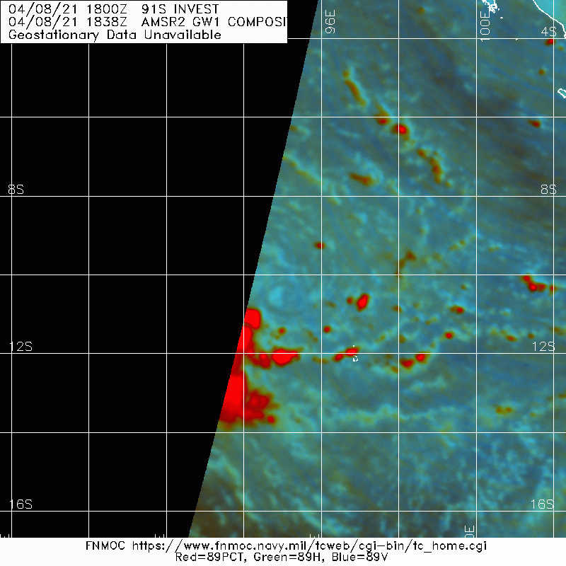
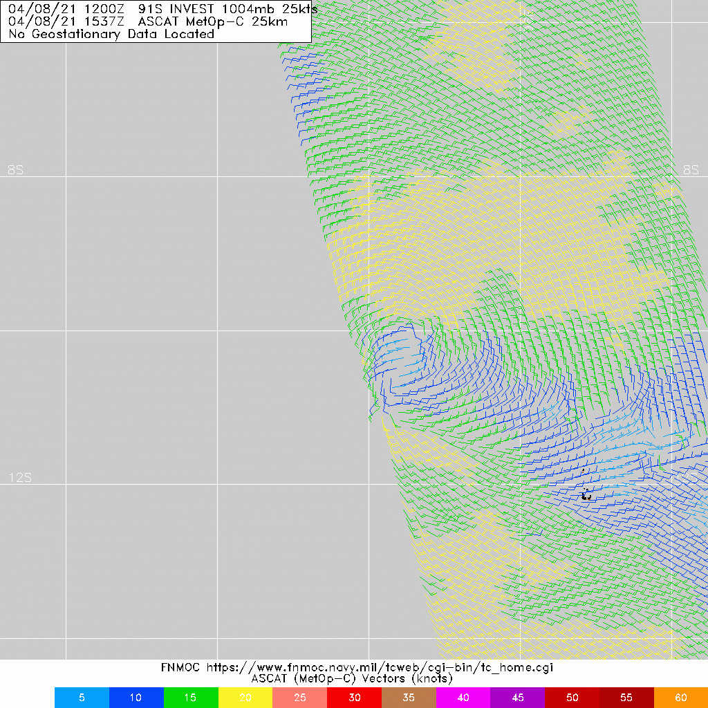
SH, 91, 2021040818, , BEST, 0, 102S, 950E, 25, 1003, TD
(1) THE AREA OF CONVECTION (INVEST 92P) PREVIOUSLY LOCATED
NEAR 12.6S 155.4E IS NOW LOCATED NEAR 13.4S 156.3E, APPROXIMATELY
407 NM EAST-NORTHEAST OF WILLIS ISLAND. ANIMATED ENHANCED INFRARED
(EIR) SATELLITE IMAGERY, SUPPORTED BY A 081731Z SSMI 85GHZ MICROWAVE
IMAGE, REVEALS DISORGANIZED, FRAGMENTED CONVECTION SURROUNDING A
PARTIALLY OBSCURE LOW LEVEL CIRCULATION (LLC) ELONGATED ALONG A
NORTHWEST TO SOUTHEAST AXIS. INVEST 92P IS IN A FAVORABLE
ENVIRONMENT FOR TROPICAL DEVELOPMENT WITH WARM (29-30C) SEA SURFACE
TEMPERATURES, LOW (5-10KTS) VERTICAL WIND SHEAR (VWS), AND EXCELLENT
RADIAL OUTFLOW. GLOBAL MODELS ARE IN GOOD AGREEMENT THAT INVEST 92P
WILL CONSOLIDATE AS IT TRACKS TO THE SOUTHEAST, REMAINING LARGELY
ASYMMETRIC, POTENTIALLY REACHING WARNING THRESHOLD IN THE NEXT
SEVERAL DAYS. MAXIMUM SUSTAINED SURFACE WINDS ARE ESTIMATED AT 20 TO
25 KNOTS. MINIMUM SEA LEVEL PRESSURE IS ESTIMATED TO BE NEAR 1004
MB. THE POTENTIAL FOR THE DEVELOPMENT OF A SIGNIFICANT TROPICAL
CYCLONE WITHIN THE NEXT 24 HOURS REMAINS LOW.
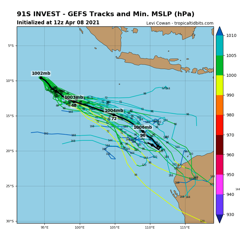
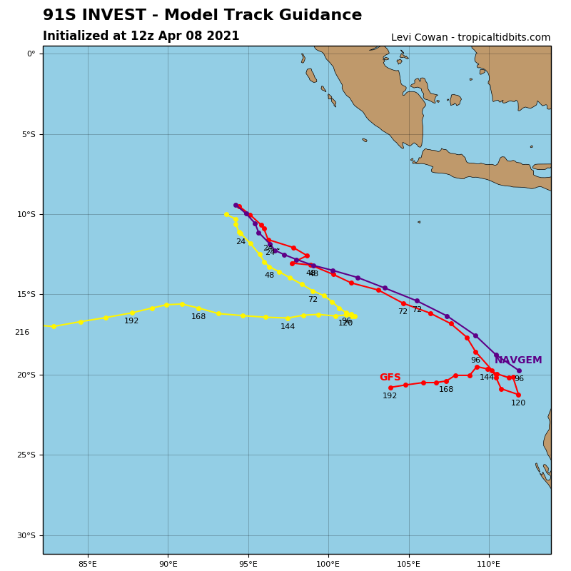
91S_gefs_latest (4).png 91S_tracks_latest.png
20210408.1838.gw1.89pct89h89v.91S.INVEST.25kts.1004mb.10.2S.95E.56pc.jpg LATEST - 2021-04-09T045820.660.jpg

回復

使用道具 舉報

簽到天數: 483 天

[LV.9]以壇為家II

dom|2021-4-9 14:04 | 顯示全部樓層
BoM將發展評級降至Low
Another tropical low (24U) lies well to the northwest of the Cocos (Keeling) Islands. It is expected to move southeast over the weekend passing close to the Cocos (Keeling) Islands on Saturday. It is unlikely to develop into a Tropical Cyclone though the Cocos (Keeling) Islands are likely to experience increased squally shower and thunderstorm activity on Saturday with gusty winds and possible heavy falls.
Thankfully, there are no other significant systems expected in the region for at least the next three days.

Likelihood of this system being a tropical cyclone in the Western Region on:
Saturday: Low
Sunday: Low
Monday: Low
91S_tracks_latest.png 91S_gefs_latest.png
回復

使用道具 舉報

簽到天數: 483 天

[LV.9]以壇為家II

dom|2021-4-10 13:45 | 顯示全部樓層
BoM不再看好發展
Another tropical low (24U) was about 140 kilometres east southeast of the Cocos (Keeling) Islands at 8am WST Saturday 10 April. It is forecast to continue moving east southeast, further from the islands. There is only a slight chance of it briefly developing overnight tonight or early Sunday, before weakening by Monday.
There are no other significant systems expected in the region for at least the next three days.

Likelihood of this system being a tropical cyclone in the Western Region on:
Sunday: Low
Monday:Very Low
3B5097B1-6DBD-4BFE-8324-A0BA6A9AC0F1.jpeg
回復

使用道具 舉報

簽到天數: 483 天

[LV.9]以壇為家II

dom|2021-4-11 14:20 | 顯示全部樓層
JTWC06Z降格擾動
91S INVEST 210411 0000 13.9S 103.3E SHEM 20 1008
860EDBEE-B2D8-4CEF-90D5-B83FB45D69DD.jpeg
回復

使用道具 舉報

12下一頁
快速回覆
您需要登錄後才可以回帖 登錄 | 立即加入

本版積分規則

本平台僅供學術討論之用,預報應以氣象局為準

威普網站虛擬主機贊助公司

臺灣第一個天氣類型社群平台 即時天氣資訊、精準颱風動態

線上客服
FB傳送訊息
廣告行銷
精準行銷 物超所值
官方粉專
發佈 快速回復 返回頂部 返回列表