|
|
本帖最後由 dom 於 2021-4-4 21:27 編輯
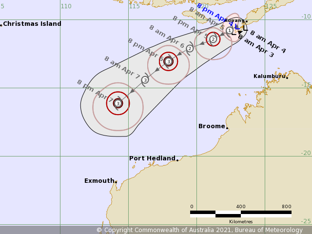
BoM升格TS, 因象限未達標而還沒有命名, 並在報文中提到因定位較接近印尼, 會留意BMKG會否對其升格IDW27600
TROPICAL CYCLONE TECHNICAL BULLETIN: AUSTRALIA - WESTERN REGION
Issued by AUSTRALIAN BUREAU OF METEOROLOGY TROPICAL CYCLONE WARNING CENTRE
at: 1309 UTC 04/04/2021
Name: Tropical Low
Identifier: 22U
Data At: 1200 UTC
Latitude: 10.5S
Longitude: 123.0E
Location Accuracy: within 30 nm [55 km]
Movement Towards: west [280 deg]
Speed of Movement: 3 knots [6 km/h]
Maximum 10-Minute Wind: 35 knots [65 km/h]
Maximum 3-Second Wind Gust: 50 knots [95 km/h]
Central Pressure: 994 hPa
Radius of 34-knot winds NE quadrant:
Radius of 34-knot winds SE quadrant:
Radius of 34-knot winds SW quadrant: 70 nm [130 km]
Radius of 34-knot winds NW quadrant: 60 nm [110 km]
Radius of 48-knot winds NE quadrant:
Radius of 48-knot winds SE quadrant:
Radius of 48-knot winds SW quadrant:
Radius of 48-knot winds NW quadrant:
Radius of 64-knot winds:
Radius of Maximum Winds:
Dvorak Intensity Code: T3.0/3.0/D1.0/24HRS STT:D0.5/06HRS
Pressure of outermost isobar: 1006 hPa
Radius of outermost closed isobar: 180 nm [335 km]
FORECAST DATA
Date/Time : Location : Loc. Accuracy: Max Wind : Central Pressure
[UTC] : degrees : nm [km]: knots[km/h]: hPa
+06: 04/1800: 10.6S 122.8E: 045 [085]: 040 [075]: 992
+12: 05/0000: 10.8S 122.4E: 055 [100]: 045 [085]: 992
+18: 05/0600: 11.1S 121.9E: 060 [110]: 045 [085]: 988
+24: 05/1200: 11.4S 121.2E: 065 [120]: 050 [095]: 986
+36: 06/0000: 12.1S 119.5E: 075 [140]: 060 [110]: 981
+48: 06/1200: 13.1S 117.9E: 100 [185]: 065 [120]: 975
+60: 07/0000: 14.4S 116.2E: 125 [230]: 075 [140]: 968
+72: 07/1200: 16.1S 114.2E: 155 [285]: 080 [150]: 964
+96: 08/1200: 18.1S 111.2E: 220 [405]: 085 [155]: 958
+120: 09/1200: 19.9S 109.8E: 295 [545]: 080 [150]: 963
REMARKS:
The system remains slow moving near the Indonesian island of Rote. Recent
microwave imagery [SSMIS at 0838 UTC] and IR show enhanced convective banding.
Dvorak FT/CI at 3.0 based on 0.7 wrap using curved band pattern and developing
trend.
However, surface winds are likely affected by land influence [mountainous
islands of Rote and Timor] and as the low is in Indonesia's area of
responsibility it is their decision to name the system. Upcoming scatterometer
passes should assist in resolving the wind circulation.
Gales are likely in exposed areas to the south of the cente.
Aside from land influences, the environment is generally favourable for further
development with deep moisture, low vertical wind shear under the axis of an
upper ridge and good outflow in northern sectors.
The system is expected to track to the southwest into the Savu Sea and
intensification is expected with unimpeded inflow once over open waters.
Steady southwest movement is forecast from Monday as the mid-level ridge
strengthens to the south, taking the system away from the Indonesian
archipelago. Further intensification is likely, despite a slight increase in
shear with the cyclone possibly reaching category 3 intensity over open waters
north of WA is possible by Tuesday evening or on Wednesday.
Interaction with another tropical system to the west makes the extended forecast
uncertain, and the various track scenarios include remaining offshore in the
Indian Ocean to an impact to the far west Pilbara coast or a later impact on the
west coast.
Copyright Commonwealth of Australia
==
The next bulletin for this system will be issued by: 04/1930 UTC. 
|
|