開啟輔助訪問
 找回密碼
 立即加入

29L.Eta 登陸佛州 轉化溫氣

簽到天數: 582 天

[LV.9]以壇為家II

蜜露|2020-11-8 08:35 | 顯示全部樓層
本帖最後由 蜜露 於 2020-11-8 08:41 編輯


hurricane-eta-110620-key.jpg

nicaragua-ETA1.jpg

12860112-16x9-xlarge.jpg

20201103.2225.f18.x.91h.29LETA.120kts-940mb-137N-833W.071pc.jpg


艾塔登陸尼加拉瓜 Cat.4 120kts 底層只有210~215  實力約普通的強颱.


尼加拉瓜、宏都拉斯 造成山洪爆發,目前人員都很安全。


回復

使用道具 舉報

簽到天數: 483 天

[LV.9]以壇為家II

dom|2020-11-8 18:58 | 顯示全部樓層
NHC判定09Z登陸古巴,登陸強度55KT
525
WTNT34 KNHC 080847
TCPAT4

BULLETIN
Tropical Storm Eta Advisory Number  32
NWS National Hurricane Center Miami FL       AL292020
400 AM EST Sun Nov 08 2020

...ETA MAKING LANDFALL ALONG THE SOUTH-CENTRAL COAST OF CUBA...
...FORECAST TO PRODUCE DANGEROUS STORM SURGE, FLASH FLOODS AND
STRONG WINDS OVER PORTIONS OF CUBA AND FLORIDA...


SUMMARY OF 400 AM EST...0900 UTC...INFORMATION
----------------------------------------------
LOCATION...21.5N 79.3W
ABOUT 90 MI...145 KM W OF CAMAGUEY CUBA
ABOUT 300 MI...485 KM S OF MIAMI FLORIDA
MAXIMUM SUSTAINED WINDS...65 MPH...100 KM/H
PRESENT MOVEMENT...NE OR 35 DEGREES AT 12 MPH...19 KM/H
MINIMUM CENTRAL PRESSURE...991 MB...29.27 INCHES
goes16_ir_29L_202011080942.gif 095313_5day_cone_no_line_and_wind.png
回復

使用道具 舉報

簽到天數: 483 天

[LV.9]以壇為家II

dom|2020-11-9 13:36 | 顯示全部樓層
環流相對鬆散,NHC定強維持55KT,預料稍後西南折並上望C1
FORECAST POSITIONS AND MAX WINDS

INIT  09/0300Z 24.6N  80.5W   55 KT  65 MPH
12H  09/1200Z 24.9N  82.6W   60 KT  70 MPH
24H  10/0000Z 24.2N  84.3W   60 KT  70 MPH
36H  10/1200Z 23.6N  85.1W   65 KT  75 MPH
48H  11/0000Z 24.2N  85.1W   65 KT  75 MPH
60H  11/1200Z 25.5N  84.9W   65 KT  75 MPH
72H  12/0000Z 26.6N  84.6W   60 KT  70 MPH
96H  13/0000Z 28.2N  83.6W   55 KT  65 MPH
120H  14/0000Z 30.0N  82.0W   45 KT  50 MPH...INLAND

$$
Forecaster Brown
040629_5day_cone_no_line_and_wind.png goes16_vis-swir_29L_202011090412.gif
回復

使用道具 舉報

簽到天數: 1650 天

[LV.Master]伴壇終老

老農民版夜神月|2020-11-11 02:57 | 顯示全部樓層
目前位於古巴西北近海,將於墨西哥灣中緩慢向北移動,NHC略微調低上望為60KT
FORECAST POSITIONS AND MAX WINDS

INIT  10/1500Z 22.7N  85.3W   50 KT  60 MPH
12H  11/0000Z 23.1N  85.4W   55 KT  65 MPH
24H  11/1200Z 24.0N  85.3W   60 KT  70 MPH
36H  12/0000Z 25.0N  85.2W   60 KT  70 MPH
48H  12/1200Z 25.9N  85.1W   55 KT  65 MPH
60H  13/0000Z 26.6N  85.2W   45 KT  50 MPH
72H  13/1200Z 27.2N  85.5W   40 KT  45 MPH
96H  14/1200Z 28.6N  86.4W   35 KT  40 MPH
120H  15/1200Z 30.1N  86.4W   30 KT  35 MPH
174900_5day_cone_with_line_and_wind.png 20201110.1740.goes-16.vis.2km.29L.ETA.50kts.992mb.22.9N.85.1W.pc.jpg
20201110.1445.gpm.89pct89h89v.29L.ETA.50kts.992mb.22.6N.85.3W.050pc.jpg GOES18512020315rW2F73.jpg
回復

使用道具 舉報

簽到天數: 601 天

[LV.9]以壇為家II

霧峰追風者|2020-11-11 08:08 | 顯示全部樓層
618
WTNT44 KNHC 102052
TCDAT4

Tropical Storm Eta Discussion Number  42
NWS National Hurricane Center Miami FL       AL292020
300 PM CST Tue Nov 10 2020

Eta's convective structure has changed little since the previous
advisory. A CDO-like feature with cloud tops colder than -70C has
persisted, with some overshooting tops of -80C to -85C located east
and southeast of the center. Recent passive microwave satellite
data indicates that Eta is still sheared from the northwest, with
an intermittent mid-level eye feature showing up. Satellite
classifications have essentially remained unchanged, with SAB
reporting 45-55 kt and TAFB reporting 55 kt. The initial intensity
remains at 50 kt based on a blend of these satellite
classifications and a UW-CIMSS SATCON estimates of 45-48 kt.

The initial motion estimate is now northward, or 360/06 kt. The
biggest surprise is the large eastward shift in all of the NHC model
guidance, which was possibly due at least in part to all of the
dropsondes that the NOAA G-IV jet aircraft dropped around Eta
earlier this morning, All of the guidance is now in good agreement
on a broad, deep-layer trough moving eastward across the
south-central and southeastern United States, which will erode the
subtropical ridge to the north of Eta that has been impeding
Eta's poleward progress he past couple of days. This generally
northward to northeastward steering pattern is expected to persist
through the entire 120-h forecast period, with only slight shifts
east or west of he current forecast track due to how vertically deep
Eta remains when it reaches the northeastern Gulf of Mexico and
Apalachee Bay in a few days. The current forecast track maintains
Eta as at least a moderate tropical cyclone through the period, with
only a slight bend back toward the northwest when the system is
expected to interact with an approaching frontal system. The new NHC
track forecast has been shifted about 150 n mi east of the previous
advisory track at 96 and 120 hours, and further eastward shifts in
the track may be required, closer to the consensus models TCVA/TVCN
and NOAA-HCCA.

Eta is forecast to remain in a low-to-moderate vertical wind shear
environment and over SSTs of at least 27 deg C for the next 36 hours
or so. Intermittent entrainment of dry mid-level air should prevent
any rapid strengthening from occurring, but Eta could still become a
hurricane between in 24 to 36 h before more significant shear begins
to affect the cyclone. By day 3 and beyond, increasing northwesterly
vertical wind shear combined with cooler SSTs should cause Eta to
weaken. The new intensity forecast is essentially the same as the
previous advisory, and is a little below the consensus models IVCN,
HCCA, and FSSE, all of which make Eta a hurricane again by 36 hours.

Due to the expected northwesterly shear after 36 hours, the 34-kt
wind radii were expanded in the eastern semicircle, which is the
side of the cyclone where most of the deep convection and associated
stronger winds will be located. Given this and the eastward
adjustment to the track forecast, a Tropical Storm Watch has been
issued for portions of the Florida west coast, and a Tropical Storm
Warning is in effect for the Dry Tortugas.

Key Messages:

1. Tropical-storm-force winds are possible along portions of the
Florida Gulf Coast by Thursday afternoon, and a Tropical Storm Watch
has been issued. Interests elsewhere along the Florida Gulf Coast
should monitor the progress of Eta, as additional watches may be
needed tonight.

2. Heavy rainfall from Eta will continue across western Cuba and
South Florida today and tonight, then potentially spread up the west
coast of the Florida Peninsula Wednesday through Thursday.
Additional flash and urban flooding will be possible in South
Florida, especially across previously inundated areas, and
eventually along portions of West Florida and the Sun Coast. Flash
and urban flooding will also be possible for western Cuba.

FORECAST POSITIONS AND MAX WINDS

INIT  10/2100Z 23.2N  85.1W   50 KT  60 MPH
12H  11/0600Z 24.1N  84.9W   55 KT  65 MPH
24H  11/1800Z 25.6N  84.8W   60 KT  70 MPH
36H  12/0600Z 26.9N  84.5W   60 KT  70 MPH
48H  12/1800Z 27.9N  84.2W   55 KT  65 MPH
60H  13/0600Z 28.7N  84.0W   45 KT  50 MPH
72H  13/1800Z 29.1N  84.0W   40 KT  45 MPH
96H  14/1800Z 29.7N  84.6W   35 KT  40 MPH
120H  15/1800Z 30.7N  84.9W   30 KT  35 MPH...INLAND

$$
Forecaster Stewart
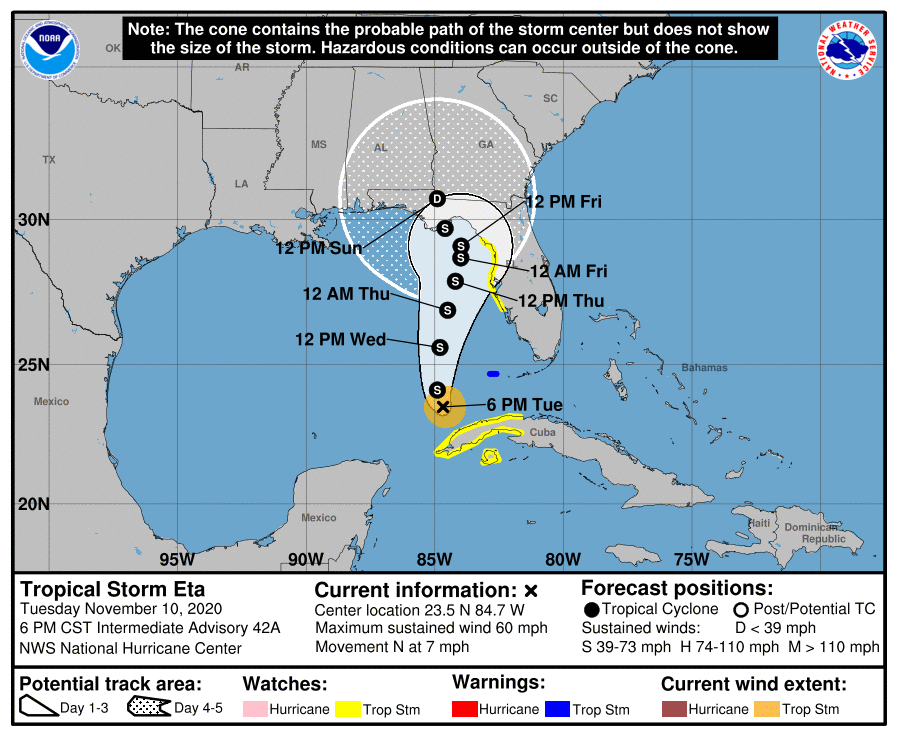
235313_5day_cone_no_line_and_wind.png


回復

使用道具 舉報

簽到天數: 483 天

[LV.9]以壇為家II

dom|2020-11-11 20:47 | 顯示全部樓層
NHC非正式報升格為一級颶風
194
WTNT64 KNHC 111239
TCUAT4

Hurricane Eta Tropical Cyclone Update
NWS National Hurricane Center Miami FL       AL292020
735 AM EST Wed Nov 11 2020

...ETA BECOMES A HURRICANE AGAIN OFFSHORE OF SOUTHWESTERN FLORIDA...

Reports from a NOAA Hurricane Hunter aircraft and Doppler radar data
indicate that Eta has re-strengthened into a hurricane offshore the
southwestern coast of Florida, with maximum sustained winds of 75
mph (120 km/h), with higher gusts.


SUMMARY OF 735 AM EST...1235 UTC...INFORMATION
----------------------------------------------
LOCATION...25.8N 83.8W
ABOUT 130 MI...210 KM WSW OF FT. MYERS FLORIDA
ABOUT 170 MI...270 KM SSW OF TAMPA FLORIDA
MAXIMUM SUSTAINED WINDS...75 MPH...120 KM/H
PRESENT MOVEMENT...NNE OR 15 DEGREES AT 15 MPH...24 KM/H
MINIMUM CENTRAL PRESSURE...983 MB...29.03 INCHES

$$
Forecaster Stewart
114331_5day_cone_no_line_and_wind.png goes16_ir_29L_202011111047.gif
回復

使用道具 舉報

簽到天數: 483 天

[LV.9]以壇為家II

dom|2020-11-12 17:46 | 顯示全部樓層
NHC判定09Z於佛羅里達州登陸,登陸強度45KT氣壓996hPa
000
WTNT64 KNHC 120917
TCUAT4

Tropical Storm Eta Tropical Cyclone Update
NWS National Hurricane Center Miami FL       AL292020
420 AM EST Thu Nov 12 2020

...ETA MAKES LANDFALL NEAR CEDAR KEY FLORIDA...

A National Ocean Service weather station indicates that Eta made
landfall near Cedar Key Florida at 400 AM EST.  Maximum sustained
winds were estimated at 50 mph (85 km/h), with a minimum central
pressure of 996 mb (29.42 inches).


SUMMARY OF 420 AM EST...0920 UTC...INFORMATION
----------------------------------------------
LOCATION...29.2N 83.0W
ABOUT 5 MI...10 KM NNE OF CEDAR KEY FLORIDA
MAXIMUM SUSTAINED WINDS...50 MPH...85 KM/H
PRESENT MOVEMENT...NE OR 40 DEGREES AT 13 MPH...20 KM/H
MINIMUM CENTRAL PRESSURE...996 MB...29.42 INCHES

$$
Forecaster Blake
FORECAST POSITIONS AND MAX WINDS

INIT  12/0900Z 29.1N  83.0W   45 KT  50 MPH
12H  12/1800Z 30.6N  81.4W   40 KT  45 MPH
24H  13/0600Z 32.6N  78.1W   35 KT  40 MPH
36H  13/1800Z 35.2N  73.4W   40 KT  45 MPH...POST-TROP/EXTRATROP
48H  14/0600Z 38.0N  67.0W   45 KT  50 MPH...POST-TROP/EXTRATROP
60H  14/1800Z...DISSIPATED

$$
Forecaster Blak
goes16_ir_29L_202011120827.gif 085535_5day_cone_no_line_and_wind.png
回復

使用道具 舉報

簽到天數: 1650 天

[LV.Master]伴壇終老

老農民版夜神月|2020-11-13 03:38 | 顯示全部樓層
已出海,將沿美國東岸北上並逐漸轉化
FORECAST POSITIONS AND MAX WINDS

INIT  12/1500Z 30.2N  81.8W   40 KT  45 MPH
12H  13/0000Z 32.0N  79.8W   40 KT  45 MPH
24H  13/1200Z 34.1N  76.0W   40 KT  45 MPH
36H  14/0000Z 37.3N  70.0W   40 KT  45 MPH...POST-TROP/EXTRATROP
48H  14/1200Z 40.5N  62.5W   45 KT  50 MPH...POST-TROP/EXTRATROP
60H  15/0000Z...DISSIPATED
175202_5day_cone_with_line_and_wind.png 20201112.1820.goes-16.vis.2km.29L.ETA.35kts.1003mb.31.2N.81.3W.pc.jpg goes16_vis_29L_202011121817.gif
回復

使用道具 舉報

快速回覆
您需要登錄後才可以回帖 登錄 | 立即加入

本版積分規則

本平台僅供學術討論之用,預報應以氣象局為準

威普網站虛擬主機贊助公司

臺灣第一個天氣類型社群平台 即時天氣資訊、精準颱風動態

線上客服
FB傳送訊息
廣告行銷
精準行銷 物超所值
官方粉專
發佈 快速回復 返回頂部 返回列表