開啟輔助訪問
 找回密碼
 立即加入

29L.Eta 登陸佛州 轉化溫氣

簽到天數: 45 天

[LV.5]常住居民I

abc|2020-11-4 00:25 | 顯示全部樓層
 風眼也沒了, ETA應該很快會減弱了
回復

使用道具 舉報

簽到天數: 1650 天

[LV.Master]伴壇終老

老農民版夜神月|2020-11-4 05:25 | 顯示全部樓層
已於21Z左右登陸尼加拉瓜,登陸強度為120KT
FORECAST POSITIONS AND MAX WINDS

INIT  03/2100Z 13.8N  83.5W  120 KT 140 MPH
12H  04/0600Z 13.8N  84.2W   75 KT  85 MPH...INLAND
24H  04/1800Z 14.1N  85.5W   40 KT  45 MPH...INLAND
36H  05/0600Z 14.7N  87.2W   25 KT  30 MPH...POST-TROP/REMNT LOW
48H  05/1800Z 15.4N  88.5W   25 KT  30 MPH...POST-TROP/REMNT LOW
60H  06/0600Z 16.3N  88.5W   25 KT  30 MPH...POST-TROP/REMNT LOW
72H  06/1800Z 17.0N  87.7W   30 KT  35 MPH...OVER WATER
96H  07/1800Z 20.0N  83.5W   40 KT  45 MPH
120H  08/1800Z 24.0N  80.5W   45 KT  50 MPH

204709_5day_cone_no_line_and_wind.png ETA.png 20201103.1903.gw1.89pct89h89v.29L.ETA.120kts.940mb.13.7N.83.3W.91pc.jpg goes16_ir_29L_202011031845.gif
回復

使用道具 舉報

簽到天數: 483 天

[LV.9]以壇為家II

dom|2020-11-4 17:05 | 顯示全部樓層
本帖最後由 dom 於 2020-11-4 18:48 編輯

Eta減弱為TS,NHC預計出海後能稍為增強至50KT
FORECAST POSITIONS AND MAX WINDS

INIT  04/0900Z 13.8N  84.7W   60 KT  70 MPH
12H  04/1800Z 14.0N  85.5W   40 KT  45 MPH...INLAND
24H  05/0600Z 14.6N  87.0W   30 KT  35 MPH...INLAND
36H  05/1800Z 15.5N  88.5W   25 KT  30 MPH...POST-TROP/REMNT LOW
48H  06/0600Z 16.5N  88.7W   25 KT  30 MPH...POST-TROP/REMNT LOW
60H  06/1800Z 17.6N  87.6W   30 KT  35 MPH...OVER WATER
72H  07/0600Z 19.0N  85.5W   35 KT  40 MPH
96H  08/0600Z 22.6N  81.8W   45 KT  50 MPH
120H  09/0600Z 25.0N  81.5W   50 KT  60 MPH

$$
Forecaster Pasch

goes16_vis-swir_29L_202011040625.gif 085832_5day_cone_no_line_and_wind.png
回復

使用道具 舉報

簽到天數: 1650 天

[LV.Master]伴壇終老

老農民版夜神月|2020-11-5 03:53 | 顯示全部樓層
將於陸地上短暫退化為殘餘低氣壓,而後出海二度發展
按慣例如果沒跨洋應該是不會換編號和名子,出海後應該還是會叫29L.Eta
FORECAST POSITIONS AND MAX WINDS

INIT  04/1500Z 13.9N  85.2W   45 KT  50 MPH...INLAND
12H  05/0000Z 14.1N  86.3W   30 KT  35 MPH...INLAND
24H  05/1200Z 14.9N  87.7W   25 KT  30 MPH...INLAND
36H  06/0000Z 16.0N  88.7W   25 KT  30 MPH...POST-TROP/REMNT LOW
48H  06/1200Z 17.0N  88.2W   30 KT  35 MPH...OVER WATER
60H  07/0000Z 18.0N  86.4W   35 KT  40 MPH
72H  07/1200Z 19.6N  84.4W   40 KT  45 MPH
96H  08/1200Z 23.0N  81.5W   45 KT  50 MPH
120H  09/1200Z 25.0N  82.0W   50 KT  60 MPH
174817_5day_cone_with_line_and_wind.png
ETA.png 29L_tracks_latest.png
29L_intensity_latest.png
回復

使用道具 舉報

簽到天數: 1650 天

[LV.Master]伴壇終老

老農民版夜神月|2020-11-6 05:25 | 顯示全部樓層
本帖最後由 老農民版夜神月 於 2020-11-11 00:37 編輯

即將出海,將北上加勒比海迎來第二春,而後將穿越古巴進入墨西哥灣
FORECAST POSITIONS AND MAX WINDS

INIT  05/2100Z 15.7N  87.7W   30 KT  35 MPH...INLAND
12H  06/0600Z 16.4N  87.8W   30 KT  35 MPH...OVER WATER
24H  06/1800Z 18.1N  86.3W   35 KT  40 MPH
36H  07/0600Z 19.1N  84.8W   40 KT  45 MPH
48H  07/1800Z 20.1N  83.1W   45 KT  50 MPH
60H  08/0600Z 21.3N  81.5W   45 KT  50 MPH
72H  08/1800Z 22.4N  80.1W   50 KT  60 MPH...INLAND
96H  09/1800Z 23.5N  82.0W   50 KT  60 MPH...OVER WATER
120H  10/1800Z 24.5N  84.5W   55 KT  65 MPH

211147_5day_cone_with_line_and_wind.png 29L_tracks_latest.png 29L_intensity_latest.png
natl.png

點評

對,前期是加勒比海,後期才是墨灣。是我表達的不夠詳盡,我修一下  發表於 2020-11-8 20:52
該處仍是加勒比海喔~  發表於 2020-11-8 19:20
回復

使用道具 舉報

簽到天數: 3291 天

[LV.Master]伴壇終老

t02436|2020-11-7 23:21 | 顯示全部樓層
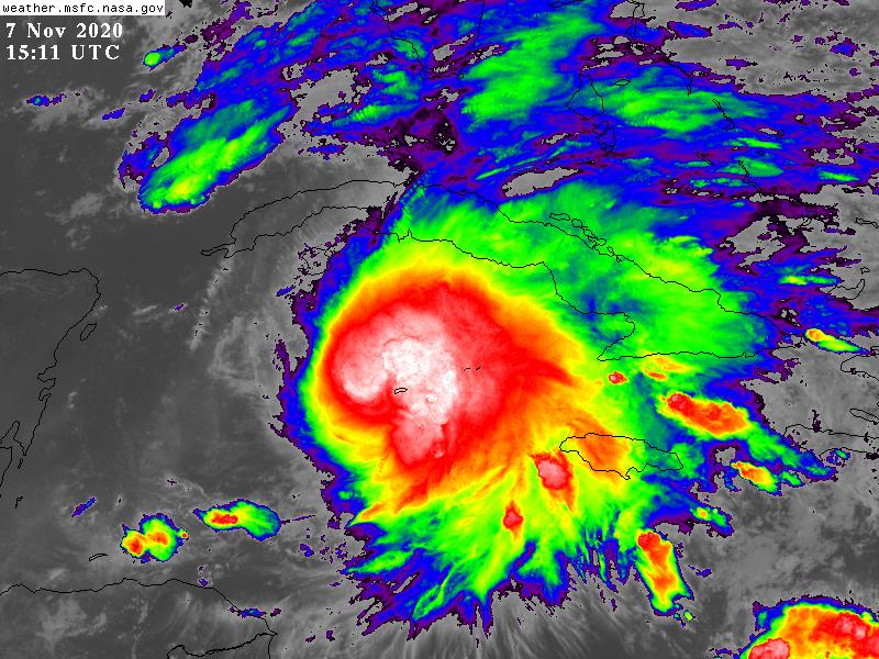
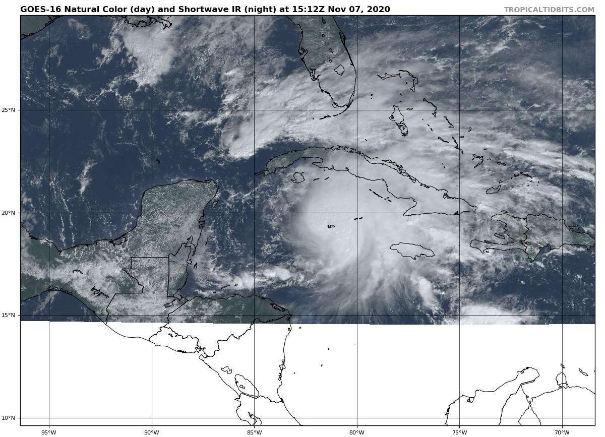
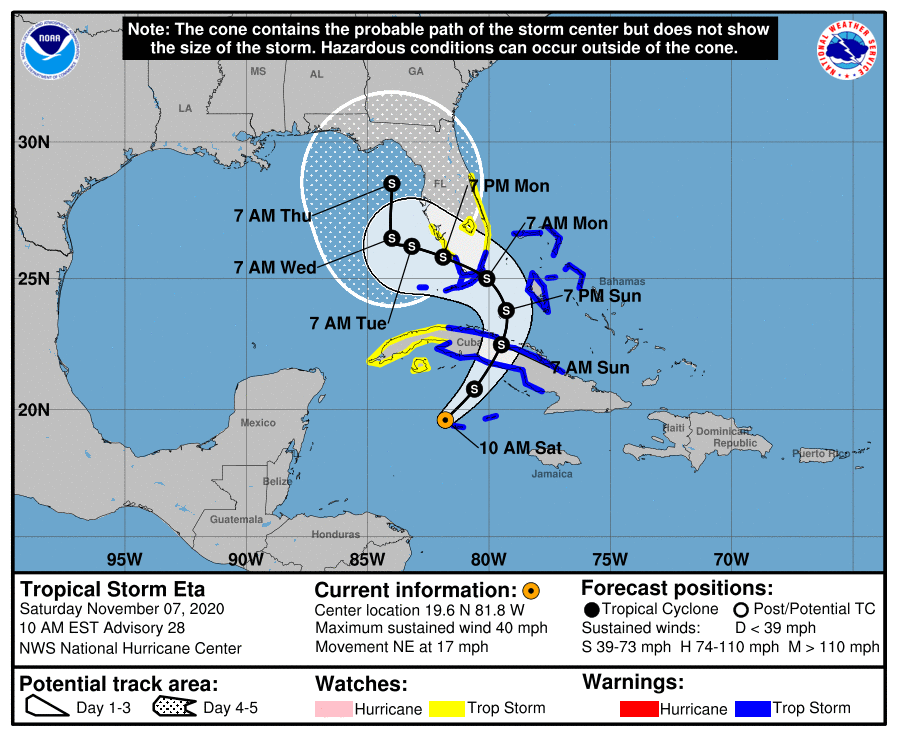
15Z重回TS,將在24小時內登陸古巴。
801
WTNT44 KNHC 071501
TCDAT4

Tropical Storm Eta Discussion Number  28
NWS National Hurricane Center Miami FL       AL292020
1000 AM EST Sat Nov 07 2020

Satellite imagery and surface data indicate that Eta has become a
little better organized this morning, with the center re-forming to
the northeast near an area of deep convection.  Surface
observations from Grand Cayman Island show that the system has
regained tropical-storm strength, and the initial intensity is
increased to 35 kt.

The initial motion is uncertain dur to the reformation, with the
best estimate of 055/15.  This general motion should continue for
the next 24 h or so as Eta is steered by a mid- to upper-level
trough over the Gulf of Mexico.  From 24-96 h, the trough is
forecast to become a cut-off low, and Eta is expected to turn
northward, northeastward, and eventually westward as it merges with
the low.  There remains some spread in the guidance in just where
these turns will occur and how close the center will come to south
Florida and the Florida Keys.  This part of the new track is nudged
just a little north of the previous track.  After 96 h, Eta should
move slowly across the eastern Gulf of Mexico, with the forecast
track showing a northward motion as a compromise of the
poorly-agreeing guidance.

Although the storm is experiencing moderate to strong southwesterly
shear, strong upper-level divergence caused by the trough should
allow strengthening through about 48 h, although the cyclone may
acquire some subtropical characteristics as it merges with the
baroclinic system.  After that time, dry air entrainment is likely
to cause Eta to slowly weaken through the remainder of the forecast
period.  The new intensity forecast is unchanged from the old
forecast.

The new forecast track requires a Tropical Storm Warning for south
Florida and the Florida Keys at this time.

Key Messages:

1. Heavy rainfall will continue across the Cayman Islands, portions
of Cuba and Jamaica, and will spread north into the Bahamas and
southern Florida. This rain may result in significant,
life-threatening flash flooding and river flooding in Cuba. Flash
and urban flooding will also be possible for the Cayman Islands,
Jamaica, the Bahamas and southern Florida.

2. Tropical storm conditions are expected today and Sunday in
portions of the Cayman Islands, Cuba, and the northwestern Bahamas,
where a Tropical Storm Warning is in effect.

3. Tropical storm conditions are expected by late Sunday in the
Florida Keys and along portions of the southeast Florida coast,
where a Tropical Storm Warning is in effect. Tropical storm
conditions are possible elsewhere in portions of southern and
central Florida beginning Sunday night, where a Tropical Storm Watch
is in effect. Additional Tropical Storm Warnings will likely be
needed later today.


FORECAST POSITIONS AND MAX WINDS

INIT  07/1500Z 19.6N  81.8W   35 KT  40 MPH
12H  08/0000Z 20.8N  80.6W   40 KT  45 MPH
24H  08/1200Z 22.5N  79.5W   45 KT  50 MPH...INLAND
36H  09/0000Z 23.8N  79.3W   50 KT  60 MPH...OVER WATER
48H  09/1200Z 25.0N  80.1W   55 KT  65 MPH
60H  10/0000Z 25.8N  81.9W   55 KT  65 MPH
72H  10/1200Z 26.2N  83.2W   50 KT  60 MPH
96H  11/1200Z 26.5N  84.0W   45 KT  50 MPH
120H  12/1200Z 28.5N  84.0W   40 KT  45 MPH

$$
Forecaster Beven
150328_5day_cone_with_line.png

GOES15112020312b9aEDF.jpg

ae70d1f9-0752-4f4c-b160-4fbfa25669d8.jpg
回復

使用道具 舉報

簽到天數: 45 天

[LV.5]常住居民I

abc|2020-11-8 00:07 | 顯示全部樓層
最新 29L_geps_latest.png 29L_intensity_latest.png
AL292020_5day_cone_no_line_and_wind.png


回復

使用道具 舉報

簽到天數: 582 天

[LV.9]以壇為家II

蜜露|2020-11-8 08:35 | 顯示全部樓層
本帖最後由 蜜露 於 2020-11-8 08:41 編輯


hurricane-eta-110620-key.jpg

nicaragua-ETA1.jpg

12860112-16x9-xlarge.jpg

20201103.2225.f18.x.91h.29LETA.120kts-940mb-137N-833W.071pc.jpg


艾塔登陸尼加拉瓜 Cat.4 120kts 底層只有210~215  實力約普通的強颱.


尼加拉瓜、宏都拉斯 造成山洪爆發,目前人員都很安全。


回復

使用道具 舉報

快速回覆
您需要登錄後才可以回帖 登錄 | 立即加入

本版積分規則

本平台僅供學術討論之用,預報應以氣象局為準

威普網站虛擬主機贊助公司

臺灣第一個天氣類型社群平台 即時天氣資訊、精準颱風動態

線上客服
FB傳送訊息
廣告行銷
精準行銷 物超所值
官方粉專
發佈 快速回復 返回頂部 返回列表