開啟輔助訪問
 找回密碼
 立即加入

25L.Gamma 巔峰登陸墨西哥

簽到天數: 1650 天

[LV.Master]伴壇終老

2020-10-1 20:58 | 顯示全部樓層
  熱帶風暴  
編號:25 L
名稱:Gamma
231453ywue9re579vzd7p9.jpg
  基本資料  
擾動編號日期:2020 10 01 20
命名日期  :2020 10 03 08
撤編日期  :2020 10 00 00
登陸地點  :墨西哥

  巔峰時期資料  
近中心最強風速 :60  kt
( TS)
海平面最低氣壓 :986 百帕

  擾動編號資料  

91L.INVEST.20kts-1008mb-15.4N-81.0W
20201001.1230.goes-16.vis.2km.91L.INVEST.20kts.1008mb.15.4N.81W.pc.jpg

  NHC:40%  
1. A tropical wave located over the west-central Caribbean Sea is
producing a large area of disorganized showers and thunderstorms.  
Conditions are expected to be conducive for development of this
system, and a tropical depression is likely to form over the
northwestern Caribbean Sea or the south-central Gulf of Mexico,
possibly before the system reaches the east coast of the Yucatan
Peninsula on Saturday.  Interests in Belize, the Yucatan Peninsula
of Mexico, and western Cuba should monitor the progress of this
disturbance.
* Formation chance through 48 hours...medium...40 percent.
* Formation chance through 5 days...high...70 percent.

two_atl_2d1 (2) (6).png two_atl_5d1 (2) (3).png
以上資料來自:NHC、颱風論壇整理製作

評分

參與人數 1水氣能量 +15 +1 收起 理由
s6815711 + 15 + 1 熱帶擾動首帖

查看全部評分

回復

使用道具 舉報

簽到天數: 1650 天

[LV.Master]伴壇終老

老農民版夜神月|2020-10-2 08:01 | 顯示全部樓層
NHC展望提升至High,70%/80%
1. A broad area of low pressure has developed over the west-central
Caribbean Sea just north of the northeastern coast of Honduras.
Satellite images indicate that showers and thunderstorms are slowly
becoming better organized, and a NOAA buoy northeast of the center
has reported winds to near tropical storm force during the past few
hours.  Environmental conditions are expected to be conducive for a
tropical depression or a tropical storm to form on Friday or
Saturday, but only if the system moves and remains over the waters
of the northwestern Caribbean Sea or southern Gulf of Mexico.  
Development will become less likely if the system moves over the
Yucatan Peninsula or northern Central America.  Regardless of
development, this system is expected to produce locally heavy rains,
with possible flash flooding, over portions of southeastern Mexico,
Central America, and western Cuba during the next several days, and
interests in those areas should monitor the progress of this
disturbance.  An Air Force Reserve reconnaissance aircraft is
scheduled to investigate the system tomorrow afternoon, if
necessary.
* Formation chance through 48 hours...high...70 percent.
* Formation chance through 5 days...high...80 percent.

two_atl_2d1 (2) (7).png two_atl_5d1 (2) (4).png
20201001.2020.goes-16.vis.2km.91L.INVEST.25kts.1007mb.16N.83.3W.pc.jpg LATEST (28).jpg
回復

使用道具 舉報

簽到天數: 1650 天

[LV.Master]伴壇終老

老農民版夜神月|2020-10-2 09:25 | 顯示全部樓層
FWC—N02/0100Z發布TCFA
WTNT21 KNGU 020100
SUBJ/TROPICAL CYCLONE FORMATION ALERT/
1. FORMATION OF A SIGNIFICANT TROPICAL CYCLONE IS POSSIBLE WITHIN
100 NM EITHER SIDE OF A LINE FROM 16.5N 83.1W TO 21.2N 86.3W
WITHIN THE NEXT 24 HOURS. AVAILABLE DATA DOES NOT JUSTIFY
ISSUANCE OF NUMBERED TROPICAL CYCLONE WARNINGS AT THIS TIME.
WINDS IN THE AREA ARE ESTIMATED TO BE 20 TO 25 KNOTS. METSAT
IMAGERY AT 011500Z INDICATES THAT A CIRCULATION CENTER IS LOCATED
NEAR 16.3N 83.0W. THE SYSTEM IS MOVING NORTHWEST AT 14 KNOTS.
2.A BROAD AREA OF LOW PRESSURE IS DEVELOPING OVER THE WESTERN
CARIBBEAN SEA. SATELLITE DATA INDICATES THAT RAIN SHOWERS AND
THUNDERSTORMS ARE BCOMING BETTER ORGANIZED. ENVIRONMENTAL
CONDITIONS ARE EXPECTED TO CONTINUE TO BECOME MORE FAVORABLE
FOR TROPICAL DEVELOPMENT WITHIN THE NEXT 24 TO 48 HOURS.
3. THIS ALERT WILL BE REISSUED, UPGRADED TO WARNING OR CANCELLED
BY 030100Z.//
BT
#0001
NNNN
al912020.20201002010653.gif 91L_gefs_latest.png
goes16_ir_91L_202010012055.gif
回復

使用道具 舉報

簽到天數: 1650 天

[LV.Master]伴壇終老

老農民版夜神月|2020-10-2 22:59 | 顯示全部樓層
本帖最後由 老農民版夜神月 於 2020-10-2 23:07 編輯

NHC15Z升格TD25L,初報上望45KT不封頂
000
WTNT45 KNHC 021456
TCDAT5

Tropical Depression Twenty-Five Discussion Number   1
NWS National Hurricane Center Miami FL       AL252020
1100 AM EDT Fri Oct 02 2020

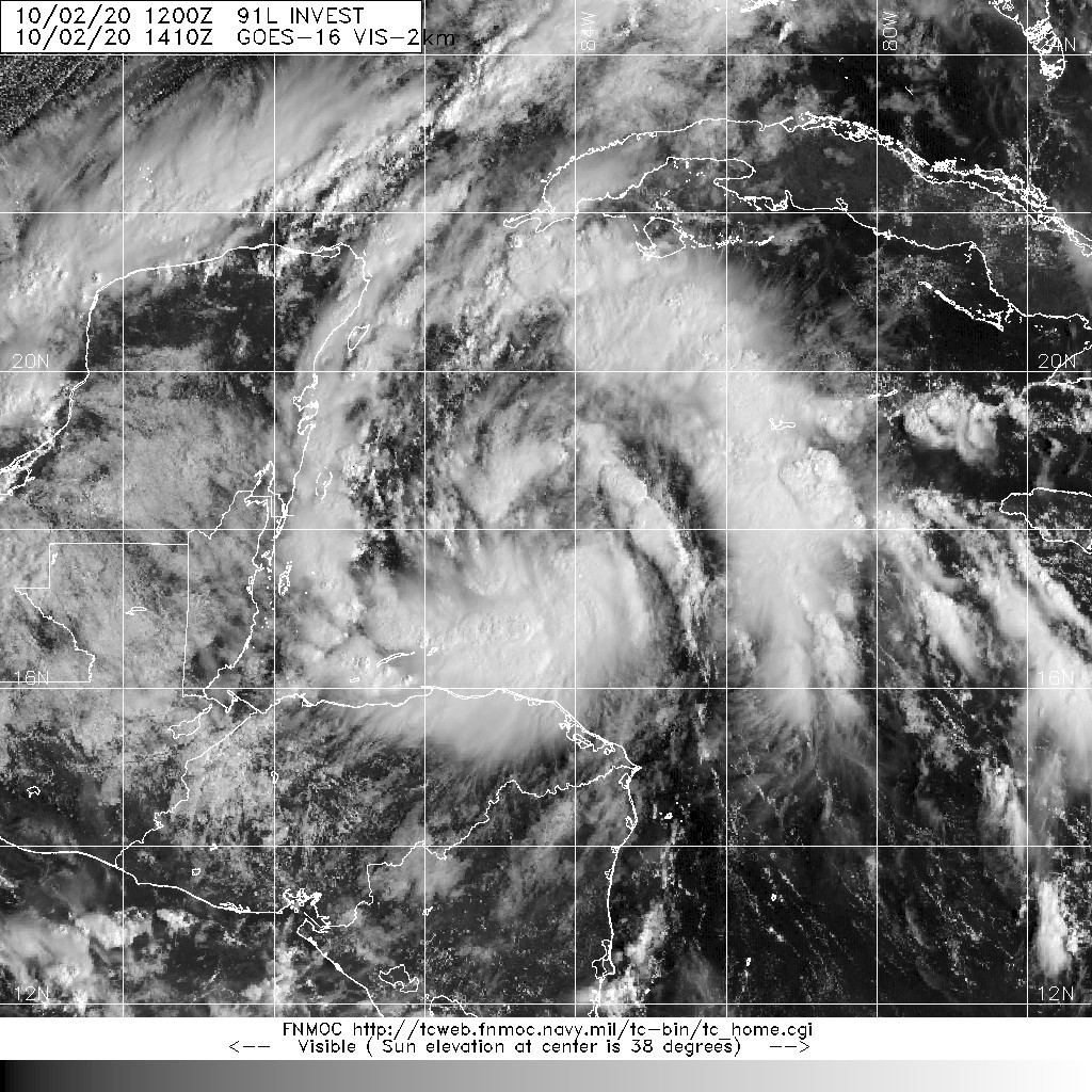
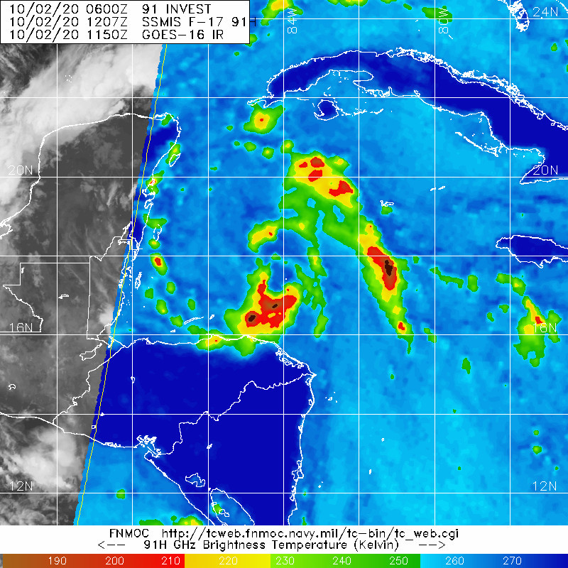
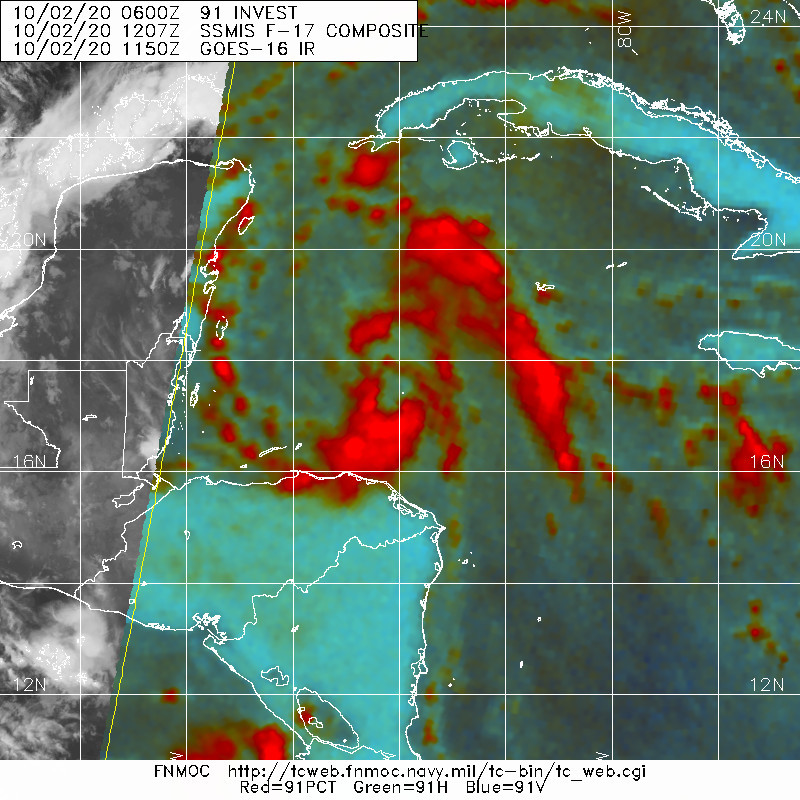
Visible satellite images show that cloudiness and showers associated
with the low pressure area over the northwestern Caribbean Sea have
become significantly better organized since yesterday, with
convective banding features becoming prominent. Moreover, low cloud
motions suggest that a closed circulation has become better defined.
Therefore, advisories are being initiated on Tropical Depression
Twenty-Five at this time.  The initial intensity estimate is 30 kt
based on Dvorak T-numbers, but an Air Force Reserve Hurricane Hunter
aircraft is scheduled to investigate the system later today to
provide a better intensity estimate.  Sea surface temperatures are
very warm, near 30 deg C, and vertical shear should remain low for
at least the next couple of days, so the cyclone is likely to become
a tropical storm by the time it nears the Yucatan Peninsula
tomorrow.  The main impediment to strengthening over the next few
days should be the interaction with land.  Given the uncertainties
about how far offshore the center will be over the next several
days, the official intensity forecast is conservative.

Since there is still a lot of scatter in the center fixes, the
initial motion estimate, 315/8 kt, is rather uncertain.  For the
next couple of days, the system is expected to move northwestward to
north-northwestward on the southwestern edge of a mid-level high
pressure area.  This would take the center near or over the
northeastern Yucatan Peninsula.  After about 48 hours, the steering
currents are not well-defined and there is considerable spread in
the track models.  At this time, it appears the cyclone should move
slowly westward over the latter part of the forecast period in
response to weak ridging over the north-central Gulf of Mexico.  The
official forecast is near or a little north of the corrected and
simple model consensus predictions.

Tropical Storm Warnings and Watches have been issued for a portion
of the Yucatan Peninsula.

KEY MESSAGES:

1. The system is expected to produce heavy rainfall that could
result in life-threatening flash flooding over portions of the
Yucatan Peninsula, far western Cuba and well away from the center in
the Mexican states of Campeche, Tabasco, and northern Chiapas.

2. The depression is forecast to become a tropical storm and bring
tropical storm conditions to portions of the Yucatan Peninsula on
Saturday, where a Tropical Storm Warning is in effect.

FORECAST POSITIONS AND MAX WINDS

INIT  02/1500Z 18.1N  84.7W   30 KT  35 MPH
12H  03/0000Z 18.9N  85.6W   30 KT  35 MPH
24H  03/1200Z 19.8N  86.6W   35 KT  40 MPH
36H  04/0000Z 20.6N  87.2W   40 KT  45 MPH...INLAND
48H  04/1200Z 21.4N  87.5W   40 KT  45 MPH...INLAND
60H  05/0000Z 22.0N  87.6W   40 KT  45 MPH
72H  05/1200Z 22.0N  88.2W   45 KT  50 MPH
96H  06/1200Z 21.5N  90.5W   45 KT  50 MPH
120H  07/1200Z 21.5N  92.5W   45 KT  50 MPH

$$
Forecaster Pasch
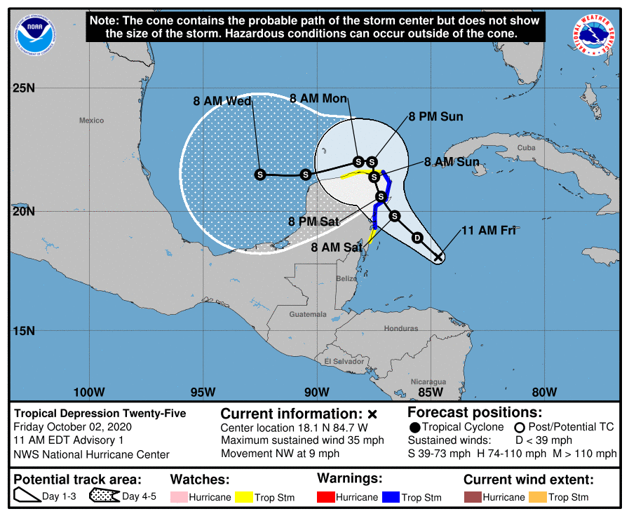
150146_5day_cone_with_line_and_wind.png
20201002.1410.goes-16.vis.2km.91L.INVEST.30kts.1005mb.17.8N.84.4W.pc.jpg 20201002.1207.f17.91h.91L.INVEST.30kts.1006mb.17.3N.84W.080pc.jpg
20201002.1207.f17.91pct91h91v.91L.INVEST.30kts.1006mb.17.3N.84W.080pc.jpg
回復

使用道具 舉報

簽到天數: 76 天

[LV.6]常住居民II

Heigo|2020-10-2 23:00 | 顯示全部樓層
本帖最後由 Heigo 於 2020-10-2 23:03 編輯

NHC升格25L
ZCZC MIATCPAT5 ALL
TTAA00 KNHC DDHHMM

BULLETINTropical Depression Twenty-Five Advisory Number   1
NWS National Hurricane Center Miami FL       AL252020
1100 AM EDT Fri Oct 02 2020

...TROPICAL DEPRESSION FORMS OVER THE NORTHWEST CARIBBEAN...
...WARNINGS AND WATCHES ISSUED FOR A PORTION OF THE YUCATAN
PENINSULA...


SUMMARY OF 1100 AM EDT...1500 UTC...INFORMATION
-----------------------------------------------
LOCATION...18.1N 84.7W
ABOUT 220 MI...355 KM SE OF COZUMEL MEXICO
MAXIMUM SUSTAINED WINDS...35 MPH...55 KM/H
PRESENT MOVEMENT...NW OR 315 DEGREES AT 9 MPH...15 KM/H
MINIMUM CENTRAL PRESSURE...1005 MB...29.68 INCHES


WATCHES AND WARNINGS
--------------------
CHANGES WITH THIS ADVISORY:

The government of Mexico has issued a Tropical Storm Warning for
the Yucatan Peninsula of Mexico from Punta Herrero to Cabo Catoche,
and a Tropical Storm Watch south of Punta Herrero to Puerto Costa
Maya and west of Cabo Catoche to Dzilam.

SUMMARY OF WATCHES AND WARNINGS IN EFFECT:

A Tropical Storm Warning is in effect for...
* Punta Herrero to Cabo Catoche

A Tropical Storm Watch is in effect for...
* South of Punta Herrero to Puerto Costa Maya
* West of Cabo Catoche to Dzilam

A Tropical Storm Warning means that tropical storm conditions are
expected somewhere within the warning area within 36 hours.

A Tropical Storm Watch means that tropical storm conditions are
possible within the watch area, generally within 48 hours.

For storm information specific to your area, please monitor
products issued by your national meteorological service.


DISCUSSION AND OUTLOOK
----------------------
At 1100 AM EDT (1500 UTC), the center of Tropical Depression
Twenty-Five was located near latitude 18.1 North, longitude 84.7
West.  The depression is moving toward the northwest near 9 mph (15
km/h), and a gradual turn toward the north-northwest with a
decrease in forward speed is expected over the next couple of
days.  On the forecast track, the center of the tropical cyclone
should be near the northeastern Yucatan Peninsula on Saturday.

Maximum sustained winds are near 35 mph (55 km/h) with higher gusts.
Some strengthening is forecast, and the depression is expected to
become a tropical storm by Saturday morning.

The estimated minimum central pressure is 1005 mb (29.68 inches).


HAZARDS AFFECTING LAND
----------------------
Key messages for the depression can be found in the Tropical Cyclone
Discussion under AWIPS header MIATCDAT5 and WMO header WTNT45 KNHC.

RAINFALL:  The depression is expected to produce rainfall of 4 to 8
inches with isolated maximum amounts of 12 inches in portions of the
Yucatan Peninsula and far western Cuba.  A separate area of
significant rain is expected to develop well away from the center in
the Mexican states of Campeche, Tabasco, and northern Chiapas, with
rainfall of 8 to 12 inches and isolated maximum amounts of 20
inches.  This rainfall may produce life-threatening flash floods and
mudslides.

Rainfall of 1 to 3 inches with maximum amounts of 5 inches is
expected in the Bay Islands of Honduras.

WIND:  Tropical storm conditions are expected within the Tropical
Storm Warning area by early Saturday, and are possible within the
Tropical Storm Watch area on Saturday and Sunday.


NEXT ADVISORY
-------------
Next intermediate advisory at 200 PM EDT.
Next complete advisory at 500 PM EDT.

$$
Forecaster Pasch

NNNN

回復

使用道具 舉報

簽到天數: 1650 天

[LV.Master]伴壇終老

老農民版夜神月|2020-10-3 08:17 | 顯示全部樓層
NHC03/00Z升格TS,命名Gamma
000
WTNT35 KNHC 022357
TCPAT5

BULLETIN
Tropical Storm Gamma Intermediate Advisory Number 2A
NWS National Hurricane Center Miami FL       AL252020
700 PM CDT Fri Oct 02 2020

...DEPRESSION BECOMES TROPICAL STORM GAMMA OVER THE NORTHWESTERN
CARIBBEAN SEA...


SUMMARY OF 700 PM CDT...0000 UTC...INFORMATION
----------------------------------------------
LOCATION...18.8N 85.8W
ABOUT 135 MI...220 KM SSE OF COZUMEL MEXICO
MAXIMUM SUSTAINED WINDS...40 MPH...65 KM/H
PRESENT MOVEMENT...NW OR 315 DEGREES AT 9 MPH...15 KM/H
MINIMUM CENTRAL PRESSURE...1000 MB...29.53 INCHES

235842_5day_cone_with_line_and_wind.png 20201002.2340.goes-16.ir.25L.TWENTY-FIV.30kts.1005mb.18.5N.85W.100pc.jpg
20201002.1905.gw1.89pct89h89v.25L.TWENTY-FIV.30kts.1005mb.18.5N.85W.94pc.jpg GOES23502020276DHDC78.jpg
回復

使用道具 舉報

簽到天數: 1650 天

[LV.Master]伴壇終老

老農民版夜神月|2020-10-3 21:44 來自手機 | 顯示全部樓層
本帖最後由 老農民版夜神月 於 2020-10-3 21:46 編輯

發展超乎預期,中心即將觸陸,NHC12Z定強已提升至55節,中心氣壓986百帕
AL, 25, 2020100312,   , BEST,   0, 197N,  872W,  55,  986, TS,

114541_5day_cone_no_line_and_wind.png 20201003.1310.goes-16.vis.2km.25L.GAMMA.55kts.986mb.19.7N.87.2W.pc.jpg
20201003.0716.gw1.89pct89h89v.25L.GAMMA.40kts.996mb.19.2N.86.6W.82pc.jpg goes16_ir_25L_202010031222.gif
回復

使用道具 舉報

簽到天數: 3291 天

[LV.Master]伴壇終老

t02436|2020-10-3 23:14 | 顯示全部樓層
即將以60節巔峰登陸墨西哥
008
WTNT45 KNHC 031457
TCDAT5

Tropical Storm Gamma Discussion Number   5
NWS National Hurricane Center Miami FL       AL252020
1000 AM CDT Sat Oct 03 2020

Observations from both the Air Force and NOAA Hurricane Hunters
indicate that Gamma has continued to strengthen this morning.  The
cloud pattern has continued to become better organized, with an eye
trying to become evident on high-resolution satellite images from
the GOES-16 mesoscale sectors.  Flight-level and SFMR-observed
surface winds from the aircraft support an intensity of 60 kt, and
the storm could strengthen a little more as long as the center
remains over water.  Since Gamma will be near or at hurricane
intensity when it makes landfall later today, the government of
Mexico has issued a Hurricane Warning for a portion of the
northeastern Yucatan Peninsula.  Gamma should weaken some while it
moves over land tonight.  Some re-intensification is likely after
the center moves into the southern Gulf of Mexico.  However, the
numerical guidance does not show much strengthening during the next
few days, possibly due to the influence of drier air and/or the
interaction with another area of low pressure to the east of Gamma.
The official intensity forecast is near or above the model
consensus.

Gamma continues northwestward at near 8 kt.  The cyclone is
expected to turn north-northwestward and move through a break in
the subtropical ridge through 36 hours or so.  Thereafter, a trough
to the north moves eastward, bypassing Gamma, and later in the
forecast period a ridge builds weakly over the Gulf of Mexico.  
This should cause the cyclone to turn toward the west and
southwest.  The official track forecast is close to the multi-model
consensus, TVCN.

Although Gamma has strengthened, its biggest threat continues to be
torrential rains, flooding, and mudslides especially near and over
mountainous terrain.


KEY MESSAGES:

1. Gamma is expected to produce heavy rainfall for several
days over portions of southeastern Mexico, the Yucatan
Peninsula, Central America, and far western Cuba.  This
rainfall could result in life-threatening flash flooding
and mudslides, particularly in the mountainous regions of
southeastern Mexico and Central America.

2. Gamma is very near hurricane strength and will be near or at
hurricane intensity when the center moves inland over the Yucatan
Peninsula later today.  A Hurricane Warning is now in effect
for portions of the east coast of the Yucatan Peninsula, where
tropical storm conditions are already occurring.  Tropical storm
conditions are expected along the north coast of the Yucatan
Peninsula within the Tropical Storm Warning area later today
and on Sunday.


FORECAST POSITIONS AND MAX WINDS

INIT  03/1500Z 20.0N  87.3W   60 KT  70 MPH
12H  04/0000Z 20.8N  87.8W   55 KT  65 MPH...INLAND
24H  04/1200Z 21.8N  88.1W   40 KT  45 MPH...OVER WATER
36H  05/0000Z 22.2N  88.3W   40 KT  45 MPH
48H  05/1200Z 22.3N  88.8W   45 KT  50 MPH
60H  06/0000Z 22.1N  89.7W   50 KT  60 MPH
72H  06/1200Z 22.0N  91.0W   50 KT  60 MPH
96H  07/1200Z 21.0N  92.5W   45 KT  50 MPH
120H  08/1200Z 20.0N  93.5W   40 KT  45 MPH

$$
Forecaster Pasch

150003_5day_cone_with_line.png

GOES150120202777SJNNj.jpg

goes16_truecolor_25L_202010031357.gif
回復

使用道具 舉報

12下一頁
快速回覆
您需要登錄後才可以回帖 登錄 | 立即加入

本版積分規則

本平台僅供學術討論之用,預報應以氣象局為準

威普網站虛擬主機贊助公司

臺灣第一個天氣類型社群平台 即時天氣資訊、精準颱風動態

線上客服
FB傳送訊息
廣告行銷
精準行銷 物超所值
官方粉專
發佈 快速回復 返回頂部 返回列表