開啟輔助訪問
 找回密碼
 立即加入

20L.Teddy 轉化溫低

簽到天數: 601 天

[LV.9]以壇為家II

2020-9-11 07:57 | 顯示全部樓層
本帖最後由 周子堯@FB 於 2020-9-25 06:38 編輯

  四級颶風  
編號:20 L
名稱:Teddy

051443h005zd0z00a8a0zb.jpg
  基本資料  
擾動編號日期:2020 09 11 07
命名日期  :2020 09 14 17
撤編日期  :2020 09 24 20
登陸地點  :

  巔峰時期資料  
近中心最強風速 :120  kt
( Cat.4 )
海平面最低氣壓 :947 百帕

  擾動編號資料  

95L.INVEST.15kts-1007mb-10N-25W 20200910.2320.goes-16.ir.95L.INVEST.15kts.1007mb.10N.25W.100pc.jpg
3. A tropical wave is located a few hundred miles southeast of the
Cabo Verde Islands and is producing a large area of disorganized
showers and thunderstorms.  Gradual development of this system is
forecast, and a tropical depression is expected to form within the
next few days while the system moves generally westward across the
eastern and central tropical Atlantic.
* Formation chance through 48 hours...medium...60 percent.
* Formation chance through 5 days...high...90 percent.

two_atl_2d3.png
以上資料來自:NHC、颱風論壇整理製作

評分

參與人數 1水氣能量 +15 +1 收起 理由
t02436 + 15 + 1

查看全部評分

回復

使用道具 舉報

簽到天數: 1650 天

[LV.Master]伴壇終老

老農民版夜神月|2020-9-12 04:17 | 顯示全部樓層
FWC-N發布TCFA
WTNT22 KNGU 111900
SUBJ/TROPICAL CYCLONE FORMATION ALERT (95L)//
REF/A/FLEWEACEN NORFOLK VA/111800Z SEP 20//
AMPN/REF A IS TROPICAL CYCLONE FORMATION ALERT 96L
(WTNT21 KNGU 111800)//
RMKS/1.FORMATION OF A SIGNIFICANT
TROPICAL CYCLONE IS POSSIBLE WITHIN
100 NM EITHER SIDE OF A LINE FROM 11.3N 27.3W TO 12.4N 32.5W
WITHIN THE NEXT 24 HOURS. AVAILABLE DATA DOES NOT JUSTIFY
ISSUANCE OF NUMBERED TROPICAL CYCLONE WARNINGS AT THIS TIME.
WINDS IN THE AREA ARE ESTIMATED TO BE 25 KNOTS. METSAT
IMAGERY AT 111900Z INDICATES THAT A CIRCULATION CENTER IS LOCATED
NEAR 11.3N 27.3W. THE SYSTEM IS MOVING WESTWARD AT 13 KNOTS.
2.REMARKS: A LARGE AREA OF DISORGANIZED SHOWERS AND THUNDERSTORMS
A FEW HUNDRED MILES SOUTH-SOUTHWEST OF THE CABO VERDE ISLANDS
IS ASSOCIATED WITH A BROAD AREA OF LOW PRESSURE. ENVIRONMENTAL
CONDITIONS ARE MARGINALLY CONDUCIVE FOR DEVELOPMENT OF THIS SYSTEM
AND A TROPICAL DEPRESSION IS LIKELY TO FORM DURING THE NEXT 24
HOURS AS IT MOVES WESTWARD AT 10 TO 15 KT OVER THE EASTERN TROPICAL
ATLANTIC.
3.THIS ALERT WILL BE REISSUED, UPGRADED TO WARNING OR CANCELLED
BY 121900Z.
4.SEE REF A FOR DETAILS ON A TROPICAL CYCLONE FORMATION ALERT 96L
LOCATED NEAR 25.0N 78.0W//

al952020.gif LATEST.jpg
20200911.1823.f18.91pct91h91v.95L.INVEST.25kts.1008mb.11.3N.27.3W.100pc.jpg

評分

參與人數 1水氣能量 +15 收起 理由
king111807 + 15 TCFA

查看全部評分

回復

使用道具 舉報

簽到天數: 1650 天

[LV.Master]伴壇終老

老農民版夜神月|2020-9-13 03:28 | 顯示全部樓層
NHC升格20L
AL, 20, 2020091218, , BEST, 0, 112N, 332W, 30, 1005, LO, 34
Potential Tropical Cyclone TWENTY
As of 18:00 UTC Sep 12, 2020:

Location: 11.2°N 33.2°W
Maximum Winds: 30 kt
Minimum Central Pressure: 1005 mb
Environmental Pressure: 1009 mb
Radius of Circulation: 150 nm
Radius of Maximum wind: 110 nm

20200912.1850.goes-16.vis.2km.20L.TWENTY.30kts.1005mb.11.2N.33.2W.pc.jpg 20200912.1836.f16.91h.20L.TWENTY.30kts.1005mb.11.2N.33.2W.075pc.jpg
20200912.1836.f16.91pct91h91v.20L.TWENTY.30kts.1005mb.11.2N.33.2W.075pc.jpg
回復

使用道具 舉報

簽到天數: 1650 天

[LV.Master]伴壇終老

老農民版夜神月|2020-9-14 18:58 | 顯示全部樓層
本帖最後由 老農民版夜神月 於 2020-9-14 19:08 編輯

09Z升格TS,命名Teddy,上望100KT
000
WTNT45 KNHC 140859
TCDAT5

Tropical Storm Teddy Discussion Number   7
NWS National Hurricane Center Miami FL       AL202020
500 AM AST Mon Sep 14 2020

Earlier ASCAT data indciated peak winds of 33 kt in the northwestern
quadrant of the depression. Since then, convection has increased and
so have the various satellite intensity estimates. The initial
intensity is increased to 35 kt based on the ASCAT data, and
satellite estimates of T3.5/35 kt from TAFB and 38 kt from UW-CIMSS
SATCON. This makes Tropical Storm Teddy the earliest 19th named
storm, besting the unnamed tropical storm on October 4, 2005.

The initial motion estimate is 285/12 kt. A deep-layer subtropical
ridge positioned over the central Atlantic should keep Teddy moving
west-northwestward for the next couple of days. Thereafter, the
ridge is expected to shift northward and eastward, and the
strengthening cyclone is forecast to turn northwestward around the
western periphery of the ridge. The latest NHC track guidance is
general agreement on this developing track scenario, and the new
official forecast track is similar to the previous one and lies down
the middle of the guidance envelope, close to the consensus model
tracks.

Teddy will have several days to strengthen over very warm ocean
temperatures and within a light vertical wind shear regime. The
only hindrance to intensification will be intermittent intrusions  
of dry mid-level air that will briefly disrupt the inner-core
convective structure. The NHC intensity forecast remains unchanged
and brings Teddy major hurricane strength by the middle of the week.
Some of the dynamical hurricane models continue to indicate that
Teddy could strengthen faster than that, but I can't bear to make
that forecast at this time.

FORECAST POSITIONS AND MAX WINDS

INIT  14/0900Z 13.4N  40.4W   35 KT  40 MPH
12H  14/1800Z 13.8N  42.4W   40 KT  45 MPH
24H  15/0600Z 14.3N  44.8W   50 KT  60 MPH
36H  15/1800Z 15.0N  46.7W   65 KT  75 MPH
48H  16/0600Z 15.9N  48.2W   75 KT  85 MPH
60H  16/1800Z 16.9N  49.5W   85 KT 100 MPH
72H  17/0600Z 18.3N  50.8W   95 KT 110 MPH
96H  18/0600Z 21.0N  53.1W  100 KT 115 MPH
120H  19/0600Z 23.9N  55.6W  100 KT 115 MPH

$$
Forecaster Stewart
091902_5day_cone_no_line_and_wind.png 20200914.1030.goes-16.vis.2km.20L.TEDDY.35kts.1004mb.13.3N.39.8W.pc.jpg 20200914.0923.f17.91pct91h91v.20L.TEDDY.35kts.1004mb.13.3N.39.8W.100pc.jpg
回復

使用道具 舉報

簽到天數: 1650 天

[LV.Master]伴壇終老

老農民版夜神月|2020-9-18 00:52 | 顯示全部樓層
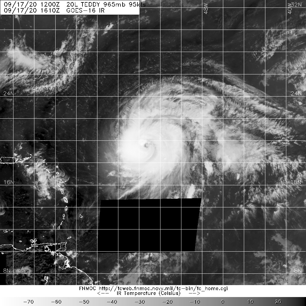
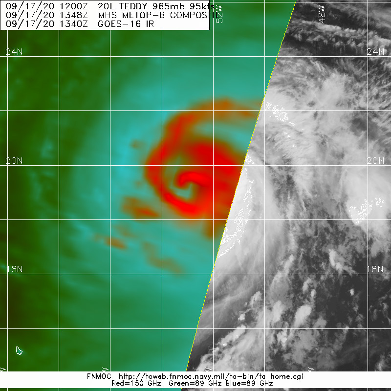
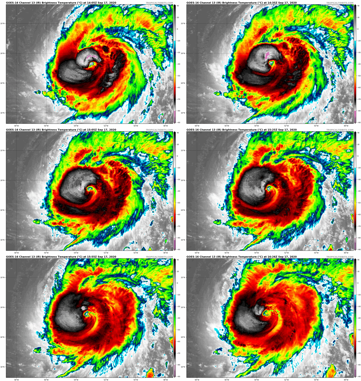
風眼開啓,15Z升格MH,定強105KT,NHC上望C4,115KT
000
WTNT45 KNHC 171502 CCA
TCDAT5

Hurricane Teddy Discussion Number  21...Corrected
NWS National Hurricane Center Miami FL       AL202020
1100 AM AST Thu Sep 17 2020

Corrected to add Key Messages

Since the previous advisory, Teddy's satellite appearance has
steadily improved. There is now a ragged warming eye surrounded by a
ring of convection with cloud tops colder than -60 degrees C. Very
recently the objective satellite intensity estimates from UW-CIMSS
have been rapidly increasing. And although a blend of the 1130 and
1200 UTC Dvorak intensity estimates from SAB and TAFB, respectively,
averaged out to an intensity of about 95 kt, the improved satellite
presentation since that time suggests that the hurricane should have
winds of at least 105 kt, which is the initial intensity for this
advisory, which could even be a little conservative based on the
latest UW-CIMMS ADT and SATCON values of 120 and 111 kt,
respectively. There will be NOAA and Air Force Reserve Hurricane
Hunter aircraft inside Teddy later today, which should provide much
more detail on the structure and intensity of Teddy.

The only negative factor for intensification during the next 24 h is
about 10 to 15 kt of vertical wind shear. However, Teddy has been
able to begin the latest burst of intensification despite that
shear. Therefore additional strengthening is anticipated through
this evening, and Teddy is forecast to become a category 4 hurricane
by tonight. The overall environment does not change significantly
for the next couple of days, so other than some fluctuations
intensity such as due to potential eyewall replacement cycles, no
change in strength is indicated during that time. As Teddy continues
moving northwest over the weekend, it is likely to begin to
encounter some of the cooler waters upwelled by Hurricane Paulette
last week. This could cause the cyclone to slowly weaken. By late
this weekend, increasing vertical wind shear should also contribute
to weakening. Due to the fast increase in intensity this morning,
the latest NHC intensity is a bit higher than all of the guidance
for the first 48 h, but the overall intensity trends are closely
mirrored by the various multi-model consensus. Beyond 48 h, the NHC
forecast closely follows the LGEM guidance.

Teddy continues to move northwestward at 10 kt. The track
forecast and reasoning both remain straightforward and unchanged for
the next 72 h. The latest NHC model guidance is in excellent
agreement that a deep-layer ridge situated over the central Atlantic
will force Teddy on a northwestward track toward the western
Atlantic.  There is a little less divergence among the models on
days 4 and 5 then on previous cycles, and these differences are
due to timing differences in where and how fast the hurricane
begins to recurve ahead of an approaching mid-latitude trough and
frontal system moving off the coast of the eastern United States in
about 3 days.  The new NHC track forecast is little changed from
the previous one, and is in the middle of the tightly clustered
track guidance. On the forecast track, Teddy will make its closest
approach to Bermuda on Monday.

Key Messages:

1. Teddy is expected to approach Bermuda as a hurricane this
weekend and make its closest approach to the island late Sunday or
Monday. While the exact details of Teddy's track and intensity near
the island are not yet known, the risk of strong winds, storm surge,
and heavy rainfall on Bermuda is increasing.

2. Swells produced by Teddy are expected to affect portions of the
Leeward Islands, the Greater Antilles, the Bahamas, Bermuda, and the
southeastern United States late this week and into the weekend.  
These swells could cause life-threatening surf and rip current
conditions.

FORECAST POSITIONS AND MAX WINDS

INIT  17/1500Z 19.3N  53.0W  105 KT 120 MPH
12H  18/0000Z 20.4N  54.0W  115 KT 130 MPH
24H  18/1200Z 21.8N  55.5W  115 KT 130 MPH
36H  19/0000Z 23.5N  57.0W  115 KT 130 MPH
48H  19/1200Z 25.5N  58.9W  110 KT 125 MPH
60H  20/0000Z 27.3N  60.9W  105 KT 120 MPH
72H  20/1200Z 28.7N  62.7W  100 KT 115 MPH
96H  21/1200Z 32.4N  63.4W   95 KT 110 MPH
120H  22/1200Z 38.9N  62.3W   85 KT 100 MPH

$$
Forecaster Latto
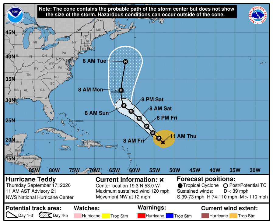
151737_5day_cone_with_line_and_wind.png 20200917.1610.goes-16.ir.20L.TEDDY.95kts.965mb.18.9N.52.7W.095pc.jpg 20200917.1348.metopb.89rgb.20L.TEDDY.95kts.965mb.18.9N.52.7W.060pc.jpg goes16_ir_20L_202009171405.gif
回復

使用道具 舉報

簽到天數: 1650 天

[LV.Master]伴壇終老

老農民版夜神月|2020-9-18 05:14 | 顯示全部樓層
21Z報升格C4,120KT。並上調上望至130KT
588
WTNT45 KNHC 172058
TCDAT5

Hurricane Teddy Discussion Number  22
NWS National Hurricane Center Miami FL       AL202020
500 PM AST Thu Sep 17 2020

Teddy has intensified quickly today, with the cyclone now having a
more symmetrical appearance while the eye has become mostly clear.
The deep convection with cloud tops ranging from -60 to -75 degrees
have surrounded the eye for much of the day, and there are
well-defined outflow channels to the south and east of the
hurricane. Both NOAA and US Air Force Reserve Hurricane Hunter
aircraft have spent time investigating Teddy today as it has been
intensifying and have been able to provide very useful data in
determining both the size and strength of the hurricane. The peak
SFMR winds measured by the aircraft this afternoon were 113 kt,
while the peak 700 mb flight-level winds were 130 kt. Based on a
reduction to 117 kt from 700 mb, and assuming some slight
undersampling may be occurring, the initial intensity has been
raised to 120 kt.

The hurricane is expected to remain in an environment of
low-moderate shear while over warm waters for the 48 h or so. And
since the period of rapid strengthening of Teddy appears to be
ongoing, the hurricane is expected to strengthen some more into
tonight. Once this round of intensification completes, there will
likely be some fluctuations in strength due to eyewall replacement
cycles and other short term changes in structure. After 48 h, the
path of Teddy should take it over some cooler waters caused by
upwelling from Hurricane Paulette last week. This should cause the
cyclone to slowly weaken. By 96 h, vertical wind shear is forecast
to increase ahead of an approaching mid-latitude trough and
associated frontal boundary. This should hasten the weakening trend
of Teddy. By 120 h, the hurricane is expected to have crossed the 26
degree SST isotherm, and will begin to interact with the
aforementioned mid-latitude system causing it to begin an
extratropical transition that may or may not be completed by the end
of the forecast period. The latest NHC intensity forecast has been
increased due to the higher initial intensity, and the forecast
trends fit well with the various intensity consensus and SHIPS
guidance.

Teddy continues its northwestward motion, now at 11 kt. The track
guidance is in very good agreement on a continuation of this motion
for the next 72 h as the cyclone is steered by a mid-level ridge
over the central Atlantic. The model guidance has come into better
agreement on the evolution of the large scale features later on in
the forecast period as the hurricane is expected to recurve ahead of
the approaching mid-latitude trough moving off the coast of the
eastern United States in a few days. The new NHC track forecast is
little changed from the previous one, and is in the middle of the
track guidance. On the forecast track, Teddy will make its closest
approach to Bermuda Sunday night into Monday.

Key Messages:

1. Teddy is expected to approach Bermuda as a hurricane this
weekend and make its closest approach to the island late Sunday or
Monday. While the exact details of Teddy's track and intensity near
the island are not yet known, the risk of strong winds, storm surge,
and heavy rainfall on Bermuda is increasing.

2. Large swells produced by Teddy are expected to affect portions of
the Leeward Islands, the Greater Antilles, the Bahamas, Bermuda, and
the southeastern United States late this week and into the weekend.
These swells could cause life-threatening surf and rip current
conditions.


FORECAST POSITIONS AND MAX WINDS

INIT  17/2100Z 20.1N  54.1W  120 KT 140 MPH
12H  18/0600Z 21.2N  55.2W  130 KT 150 MPH
24H  18/1800Z 22.8N  56.6W  125 KT 145 MPH
36H  19/0600Z 24.5N  58.1W  125 KT 145 MPH
48H  19/1800Z 26.3N  59.9W  120 KT 140 MPH
60H  20/0600Z 28.0N  62.1W  110 KT 125 MPH
72H  20/1800Z 29.5N  63.3W  105 KT 120 MPH
96H  21/1800Z 33.9N  63.0W   95 KT 110 MPH
120H  22/1800Z 41.3N  62.0W   80 KT  90 MPH

$$
Forecaster Latto
210009_5day_cone_with_line_and_wind.png 20200917.2030.goes-16.vis.2km.20L.TEDDY.110kts.951mb.19.7N.53.7W.pc.jpg
20200917.2033.f18.91pct91h91v.20L.TEDDY.110kts.951mb.19.7N.53.7W.060pc.jpg GOES20502020261z3zkCN.jpg
回復

使用道具 舉報

簽到天數: 3291 天

[LV.Master]伴壇終老

t02436|2020-9-19 00:42 | 顯示全部樓層
風眼置換中,強度略降至115節,但NHC已不再上望更高強度。
ZCZC MIATCDAT5 ALL
TTAA00 KNHC DDHHMM

Hurricane Teddy Discussion Number  25
NWS National Hurricane Center Miami FL       AL202020
1100 AM AST Fri Sep 18 2020

There was little change to the structure of Teddy since early this
morning up until the past hour or so, when the eye began to
fill in slightly while the cloud tops over the southern portion of
the circulation warmed a bit. However, new convection with very
cold cloud tops near -80 degrees C have developed recently over
the northwestern quadrant, so the cyclone could just be undergoing
a temporary intensity fluctuation that typically occurs in powerful
hurricanes. The latest Dvorak intensity estimates range from 102 kt
to 116 kt, and the initial intensity is being held at 115 kt for
this advisory. There will be staggered NOAA and U.S. Air Force
Reserve Hunter aircraft investigating Teddy starting this morning
and continuing into the late afternoon, so they will soon be able to
provide updated details on the latest structure, size, and intensity
of the hurricane.

The major hurricane continues to move northwestward, now at 10 kt.
Teddy is expected to remain on that general course during the next
couple of days as it moves on the southwestern periphery of a
mid-level ridge.  By the end of the weekend, when Teddy will likely
be approaching Bermuda, a turn to the north or north-northeast is
forecast to occur as a mid- to upper-level trough moves off the
northeastern U.S. coast. Early next week, the trough is expected to
cut off, causing Teddy to turn slightly to the left and approach
Nova Scotia in 4 to 5 days.  The models continue to be in good
agreement on this scenario, and only small adjustments were made to
the previous forecast track.

Teddy will likely fluctuate in intensity over the next day or so
while it remains in favorable conditions of low wind shear, warm
waters, and a fairly moist air mass.  By late this weekend, the
hurricane is forecast to traverse over cooler waters churned up by
Paulette last week. This should cause a weakening trend to begin.
By Monday night, vertical wind shear is expected to drastically
increase ahead of the approaching mid-latitude trough. This should
not only weaken Teddy, but begin its transition to a large
extratropical cyclone, and that transition should be completed
before the end of the forecast period. The latest NHC intensity
forecast is near the HFIP corrected consensus aid HCCA through 36
h, and then trends toward the SHIPS and LGEM intensity guidance
thereafter.

Teddy is producing a large area of high seas.  The latest maximum
seas estimated by TAFB near the core of the hurricane are near 45
feet.  Swells from Teddy are spreading far from the center, see Key
Messages below.

Key Messages:

1. Teddy is expected to approach Bermuda as a hurricane this
weekend and make its closest approach to the island late Sunday or
Monday. While the exact details of Teddy's track and intensity near
the island are not yet known, there is a risk strong winds, storm
surge, and heavy rainfall on Bermuda, and watches may be issued
later today or tonight.

2. Large swells produced by Teddy are expected to affect portions of
the Leeward Islands, the Greater Antilles, the Bahamas, Bermuda, and
the southeastern United States during the next few days. These
swells could cause life-threatening surf and rip current conditions.

FORECAST POSITIONS AND MAX WINDS

INIT  18/1500Z 22.1N  56.1W  115 KT 130 MPH
12H  19/0000Z 23.3N  57.2W  115 KT 130 MPH
24H  19/1200Z 25.2N  58.9W  115 KT 130 MPH
36H  20/0000Z 27.1N  60.7W  110 KT 125 MPH
48H  20/1200Z 28.7N  62.2W  105 KT 120 MPH
60H  21/0000Z 30.7N  62.7W  100 KT 115 MPH
72H  21/1200Z 33.7N  62.2W   95 KT 110 MPH
96H  22/1200Z 41.4N  62.5W   80 KT  90 MPH
120H  23/1200Z 46.8N  62.0W   55 KT  65 MPH...POST-TROP/EXTRATROP

$$
Forecaster Latto

NNNN

144147_5day_cone_with_line.png

20200918.1326.metopb.89rgb.20L.TEDDY.115kts.947mb.21.7N.55.8W.100pc.jpg

20200918.1600.goes-16.vis.2km.20L.TEDDY.115kts.947mb.21.7N.55.8W.pc.jpg

GOES16-AL202020-GEOCOLOR-1000x1000.gif

GOES16202020262DWKkCt.jpg
回復

使用道具 舉報

簽到天數: 1650 天

[LV.Master]伴壇終老

老農民版夜神月|2020-9-21 01:50 | 顯示全部樓層
緯度漸高,已減弱至C2,NHC預測48H內將約略維持在C2強度
000
WTNT45 KNHC 201455
TCDAT5

Hurricane Teddy Discussion Number  33
NWS National Hurricane Center Miami FL       AL202020
1100 AM AST Sun Sep 20 2020

The satellite signature of Teddy has degraded from an eye pattern
overnight into a central dense overcast this morning.  Air Force
Reserve Hurricane Hunter aircraft data indicate that the hurricane
has weakened, and the initial wind speed is set to 90 kt, perhaps
generously.  The aircraft data does still show that Teddy remains a
large hurricane, with hurricane-force winds extending outward in the
northeastward quadrant to about 70 n mi.

While the forecast intensity does not change much over the next
couple of days, the hurricane should undergo significant changes
during that time.  Teddy should not lose any more strength by late
today due to favorable positioning with an approaching trough, and
the gale-force winds should greatly expand due to this trough
interaction. In 2 or 3 days, after the system occludes and becomes
post-tropical, the cyclone should weaken because of a loss of  
extratropical forcing while over the cooler water south of Nova
Scotia.  Eventually Teddy will probably get absorbed by a larger
extratropical low around day 5.  Model guidance is fairly tightly
packed around the official wind forecast, which leans on the global
models given the substantial extratropical contributions, plus or
minus 5 kt throughout the forecast period.

The hurricane has resumed a northwestward motion or 320/8 kt. Teddy
is likely to turn northward today and north-northeastward tomorrow
due to the aforementioned trough. By early Tuesday, the cyclone
should turn back to the north-northwest as it rotates around the
same trough, then turn northeastward early Wednesday ahead of yet
another trough moving into from eastern Canada.  Although the
forecast evolution is complex, model guidance is in remarkably good
agreement, and no substantial changes were made to the previous
forecast. Regardless of the details, every model has a rather large
and strong post-tropical cyclone south of Nova Scotia in about 3
days.


Key Messages:

1. The center of Teddy is forecast to move east of Bermuda on
Monday. Tropical storm conditions are likely on the island beginning
this evening and could continue into Monday evening.

2. Teddy is expected to transition to a powerful post-tropical
cyclone as it moves near or over portions of Atlantic Canada early
next week, where there is an increasing risk of direct impacts from
wind, rain, and storm surge. Residents there should closely monitor
the progress of Teddy and updates to the forecast.

3. Large swells produced by Teddy are expected to affect portions of
the Leeward Islands, the Greater Antilles, the Bahamas, Bermuda, the
east coast of the United States, and Atlantic Canada during the next
few days. These swells could cause life-threatening surf and rip
current conditions.


FORECAST POSITIONS AND MAX WINDS

INIT  20/1500Z 28.3N  62.8W   90 KT 105 MPH
12H  21/0000Z 29.2N  63.4W   85 KT 100 MPH
24H  21/1200Z 31.0N  62.9W   85 KT 100 MPH
36H  22/0000Z 34.8N  62.1W   85 KT 100 MPH
48H  22/1200Z 38.8N  63.0W   85 KT 100 MPH
60H  23/0000Z 41.7N  63.4W   75 KT  85 MPH...POST-TROP/EXTRATROP
72H  23/1200Z 44.5N  62.0W   60 KT  70 MPH...POST-TROP/EXTRATROP
96H  24/1200Z 53.0N  53.0W   40 KT  45 MPH...POST-TROP/EXTRATROP
120H  25/1200Z 60.5N  39.5W   35 KT  40 MPH...POST-TROP/EXTRATROP

$$
Forecaster Blake
al202020.20200920150821.gif 20200920.1710.goes-16.vis.2km.20L.TEDDY.90kts.964mb.28N.62.6W.pc.jpg
20200920.1705.gw1.89pct89h89v.20L.TEDDY.90kts.964mb.28N.62.6W.74pc.jpg GOES17302020264octrJC.jpg
回復

使用道具 舉報

12下一頁
快速回覆
您需要登錄後才可以回帖 登錄 | 立即加入

本版積分規則

本平台僅供學術討論之用,預報應以氣象局為準

威普網站虛擬主機贊助公司

臺灣第一個天氣類型社群平台 即時天氣資訊、精準颱風動態

線上客服
FB傳送訊息
廣告行銷
精準行銷 物超所值
官方粉專
發佈 快速回復 返回頂部 返回列表