開啟輔助訪問
 找回密碼
 立即加入

10E 對流消長 整合多日未獲命名

簽到天數: 1650 天

[LV.Master]伴壇終老

2020-8-12 02:30 | 顯示全部樓層
  基本資料  
編號    :10 E
擾動編號日期:2020 08 12 02
撤編日期  :2020 08 19 15
92E.INVEST.15kts.1007mb.11N.138W

20200811.1600.goes-17.ir.92E.INVEST.15kts.1007mb.11N.138W.100pc.jpg

巔峰強度:30KT/1004hPa

評分

參與人數 1水氣能量 +15 +1 收起 理由
t02436 + 15 + 1

查看全部評分

回復

使用道具 舉報

簽到天數: 1650 天

[LV.Master]伴壇終老

老農民版夜神月|2020-8-12 02:43 | 顯示全部樓層
NHC於剛才發出的展望中將評級提升至Medium,40%/70%
1. Satellite imagery indicates that a poorly defined low pressure area
has formed in association with the elongated area of disturbed
weather located around 1300 miles southwest of the southern tip of
the Baja California peninsula.  Additional development is expected,
and a tropical depression is likely to form during the next few
days.  The system is expected to move slowly westward toward the
central Pacific basin during the next several days.
* Formation chance through 48 hours...medium...40 percent.
* Formation chance through 5 days...high...70 percent.

two_pac_2d1.png two_cpac_5d1.png
回復

使用道具 舉報

簽到天數: 1650 天

[LV.Master]伴壇終老

老農民版夜神月|2020-8-12 15:33 | 顯示全部樓層
JTWC發布TCFA
WTPN21 PHNC 120700
MSGID/GENADMIN/JOINT TYPHOON WRNCEN PEARL HARBOR HI//
SUBJ/TROPICAL CYCLONE FORMATION ALERT (INVEST 92E)//
RMKS/
1. FORMATION OF A SIGNIFICANT TROPICAL CYCLONE IS POSSIBLE WITHIN
A 205 NM RADIUS OF 11.4N 128.6W WITHIN THE NEXT 12 TO 24 HOURS.
AVAILABLE DATA DOES NOT JUSTIFY ISSUANCE OF NUMBERED TROPICAL
CYCLONE WARNINGS AT THIS TIME. WINDS IN THE AREA ARE ESTIMATED TO
BE 20 TO 25 KNOTS. METSAT IMAGERY AT 120600Z INDICATES THAT A
CIRCULATION CENTER IS LOCATED NEAR 11.3N 128.2W. THE SYSTEM IS
MOVING WEST-SOUTHWESTWARD AT 09 KNOTS.
2. REMARKS: AN AREA OF CONVECTION (INVEST 92E) HAS PERSISTED NEAR
11.3N 128.2W, APPROXIMATELY 1627 NM SOUTHEAST OF HILO, HAWAII.
ANIMATED MULTISPECTRAL SATELLITE IMAGERY AND A 120229Z SSMIS 91GHZ
IMAGE DEPICT AN ELONGATED BUT DEFINED LOW LEVEL CIRCULATION (LLC)
WITH SHALLOW AND WEAK FORMATIVE BANDING BEGINNING TO WRAP INTO THE
CENTER. AN 111818Z METOP-B ASCAT PASS SHOWS THE ELONGATED WIND FIELD
OF MOSTLY 15-20 KTS WITH SOME 25-30 KT WINDS IN THE SOUTHEASTERN
QUADRANT. INVEST 92E IS CURRENTLY IN A FAVORABLE ENVIRONMENT FOR
DEVELOPMENT WITH GOOD UPPER LEVEL OUTFLOW, LOW (<15 KTS) VERTICAL
WIND SHEAR, AND WARM (28-30C) SEA SURFACE TEMPERATURES. GLOBAL
MODELS ARE IN GOOD AGREEMENT THAT INVEST 92E WILL CONTINUE TO
INTENSIFY AND TRACK GENERALLY WEST-NORTHWESTWARD. MAXIMUM SUSTAINED
SURFACE WINDS ARE ESTIMATED AT 20 TO 25 KNOTS. MINIMUM SEA LEVEL
PRESSURE IS ESTIMATED TO BE NEAR 1004 MB. THE POTENTIAL FOR THE
DEVELOPMENT OF A SIGNIFICANT TROPICAL CYCLONE WITHIN THE NEXT 24
HOURS IS HIGH.
3. THIS ALERT WILL BE REISSUED, UPGRADED TO WARNING OR CANCELLED BY
130700Z.
//
NNNN
ep9220.gif 20200812.0700.goes-17.ir.92E.INVEST.25kts.1008mb.11.3N.128.2W.100pc.jpg
20200812.0229.f17.composite.92E.INVEST.25kts.1007mb.12.3N.126.3W.065pc.jpg

評分

參與人數 1水氣能量 +15 收起 理由
king111807 + 15 TCFA

查看全部評分

回復

使用道具 舉報

簽到天數: 1650 天

[LV.Master]伴壇終老

老農民版夜神月|2020-8-13 02:52 | 顯示全部樓層
NHC展望提升至80%
1. Satellite images suggest that a better-defined low pressure area is
forming about 1300 miles southwest of the southern tip of the Baja
California peninsula, and the associated shower and thunderstorm
activity is becoming a little better organized.  Environmental
conditions are conducive for additional development, and a tropical
depression is expected to form within the next couple of days while
the system moves slowly west-northwestward.
* Formation chance through 48 hours...high...80 percent.
* Formation chance through 5 days...high...90 percent.

two_pac_2d1.png two_pac_5d1.png
回復

使用道具 舉報

簽到天數: 601 天

[LV.9]以壇為家II

霧峰追風者|2020-8-13 08:04 | 顯示全部樓層
NHC 展望提升至90%。
1. Satellite imagery indicates that the area of low pressure located
about 1300 miles southwest of the southern tip of the Baja
California peninsula continues to become better defined.  The
associated shower and thunderstorm activity is also showing
some signs of organization.  Conditions are expected to remain
conducive for additional development, and a tropical depression is
likely to form tonight or Thursday while the system moves slowly
west-northwestward.
* Formation chance through 48 hours...high...90 percent.
* Formation chance through 5 days...high...90 percent.
two_pac_2d1.png
回復

使用道具 舉報

簽到天數: 2141 天

[LV.Master]伴壇終老

周子堯@FB|2020-8-13 16:54 | 顯示全部樓層
本帖最後由 周子堯@FB 於 2020-8-13 17:02 編輯

NHC 升格 TD-10E,短暫發展
WTPZ45 KNHC 130839
TCDEP5

Tropical Depression Ten-E Discussion Number   1
NWS National Hurricane Center Miami FL       EP102020
200 AM PDT Thu Aug 13 2020

Satellite images over the past several hours have shown a gradual
increase in the organized deep convection associated with an area of
low pressure located about 1400 miles west-southwest of the southern
tip of the Baja California peninsula. In addition, a recent ASCAT
overpass revealed that the low level circulation has become
well-defined. Based on these data, advisories have been initiated on
Tropical Depression Ten-E. The ASCAT wind data indicated 25-30 kt
peak winds. This along with Dvorak satellite intensity estimates
from TAFB and SAB support an initial advisory intensity of 30 kt. It
should be noted that the ASCAT data showed that there were a few 35
kt wind vectors about 45 n mi west of the center of the system and
these are presumed to be rain-contaminated.

The depression is expected to be in a marginally conducive
environment for strengthening throughout the 5-day forecast period.
Although the system is forecast to remain over sufficiently warm
waters, SHIPS guidance suggests that moderate northeasterly
vertical wind shear will prevail over the system for the next
several days. Late in the forecast period, the cyclone may encounter
some drier air which would also inhibit strengthening. The official
forecast shows only slight strengthening in the next 24 h, and no
change in intensity thereafter. This is in good agreement with most
of the intensity guidance.

The cyclone's motion is 285/06 kt. A weak mid-level ridge to the
north of the depression is expected to steer the system slowly
westward over the next few days and the track model guidance is in
decent agreement through that time. By 72 h, the steering flow
appears to collapse, and as a result the depression is forecast to
move very slowly during the 3-5 day period.  Once the steering flow
becomes weak the models diverge a bit with some moving the cyclone
northwestward, while others move it west-southwestward. Regardless
of this spread, the majority of the models agree that the cyclone
will move very little during that time. The official forecast track
splits the difference in the model solutions beyond day 3, and
closely follows the TVCE and TVCX consensus aids throughout the
5-day forecast period.


FORECAST POSITIONS AND MAX WINDS

INIT  13/0900Z 13.5N 129.1W   30 KT  35 MPH
12H  13/1800Z 13.8N 130.2W   30 KT  35 MPH
24H  14/0600Z 13.9N 131.5W   35 KT  40 MPH
36H  14/1800Z 13.9N 132.5W   35 KT  40 MPH
48H  15/0600Z 13.8N 133.5W   35 KT  40 MPH
60H  15/1800Z 13.7N 134.1W   35 KT  40 MPH
72H  16/0600Z 13.8N 134.5W   35 KT  40 MPH
96H  17/0600Z 14.2N 135.1W   35 KT  40 MPH
120H  18/0600Z 14.6N 135.8W   35 KT  40 MPH

$$
Forecaster Latto
084041_5day_cone_no_line_and_wind.png
20200813.0830.goes-16.ir.10E.INVEST.30kts.1004mb.13.4N.128.8W.100pc.jpg

點評

哈哈,沒注意到@,已修正。  發表於 2020-8-13 17:02
咦不對,你的報文怎麼po成隔壁大西洋11L的了  發表於 2020-8-13 17:00
抱歉,沒想到會撞文...  發表於 2020-8-13 16:58
回復

使用道具 舉報

簽到天數: 1650 天

[LV.Master]伴壇終老

老農民版夜神月|2020-8-13 16:56 | 顯示全部樓層
NHC09Z升格TD10-E
000
WTPZ45 KNHC 130839
TCDEP5

Tropical Depression Ten-E Discussion Number   1
NWS National Hurricane Center Miami FL       EP102020
200 AM PDT Thu Aug 13 2020

Satellite images over the past several hours have shown a gradual
increase in the organized deep convection associated with an area of
low pressure located about 1400 miles west-southwest of the southern
tip of the Baja California peninsula. In addition, a recent ASCAT
overpass revealed that the low level circulation has become
well-defined. Based on these data, advisories have been initiated on
Tropical Depression Ten-E. The ASCAT wind data indicated 25-30 kt
peak winds. This along with Dvorak satellite intensity estimates
from TAFB and SAB support an initial advisory intensity of 30 kt. It
should be noted that the ASCAT data showed that there were a few 35
kt wind vectors about 45 n mi west of the center of the system and
these are presumed to be rain-contaminated.

The depression is expected to be in a marginally conducive
environment for strengthening throughout the 5-day forecast period.
Although the system is forecast to remain over sufficiently warm
waters, SHIPS guidance suggests that moderate northeasterly
vertical wind shear will prevail over the system for the next
several days. Late in the forecast period, the cyclone may encounter
some drier air which would also inhibit strengthening. The official
forecast shows only slight strengthening in the next 24 h, and no
change in intensity thereafter. This is in good agreement with most
of the intensity guidance.

The cyclone's motion is 285/06 kt. A weak mid-level ridge to the
north of the depression is expected to steer the system slowly
westward over the next few days and the track model guidance is in
decent agreement through that time. By 72 h, the steering flow
appears to collapse, and as a result the depression is forecast to
move very slowly during the 3-5 day period.  Once the steering flow
becomes weak the models diverge a bit with some moving the cyclone
northwestward, while others move it west-southwestward. Regardless
of this spread, the majority of the models agree that the cyclone
will move very little during that time. The official forecast track
splits the difference in the model solutions beyond day 3, and
closely follows the TVCE and TVCX consensus aids throughout the
5-day forecast period.


FORECAST POSITIONS AND MAX WINDS

INIT  13/0900Z 13.5N 129.1W   30 KT  35 MPH
12H  13/1800Z 13.8N 130.2W   30 KT  35 MPH
24H  14/0600Z 13.9N 131.5W   35 KT  40 MPH
36H  14/1800Z 13.9N 132.5W   35 KT  40 MPH
48H  15/0600Z 13.8N 133.5W   35 KT  40 MPH
60H  15/1800Z 13.7N 134.1W   35 KT  40 MPH
72H  16/0600Z 13.8N 134.5W   35 KT  40 MPH
96H  17/0600Z 14.2N 135.1W   35 KT  40 MPH
120H  18/0600Z 14.6N 135.8W   35 KT  40 MPH

$$
Forecaster Latto

084041_5day_cone_with_line_and_wind.png 20200813.0830.goes-16.ir.92E.INVEST.30kts.1004mb.13.4N.128.8W.100pc.jpg
GOES08302020226pMuoYZ.jpg

評分

參與人數 1水氣能量 +15 收起 理由
king111807 + 15 升格10E

查看全部評分

回復

使用道具 舉報

簽到天數: 2141 天

[LV.Master]伴壇終老

周子堯@FB|2020-8-15 09:49 | 顯示全部樓層
本帖最後由 周子堯@FB 於 2020-8-15 09:51 編輯

NHC 再次看好增強至TS
017
WTPZ45 KNHC 141432
TCDEP5

Tropical Depression Ten-E Discussion Number   6
NWS National Hurricane Center Miami FL       EP102020
800 AM PDT Fri Aug 14 2020

Since the last advisory, the depression has maintained a small
ragged band of convection in its southwest quadrant. Intensity
fixes from TAFB, SAB, and UW-CIMSS (both ADT and SATCON) do not
indicate that the system has changed appreciably so the intensity
remains 30 kt for this advisory.

The intensity guidance is generally more bullish on the future of
the depression than it has been previously. The COAMPS-TC and GFS
now forecast strengthening to occur in a few days, and the latter of
those models forms a symmetric CDO with an eye in simulated
satellite imagery around day 5. In the short term, strong
northeasterly shear should continue to limit the development
potential of the cyclone, but upper-level winds could become less
hostile in a few days. The main change to the NHC intensity forecast
was to maintain the system as a tropical cyclone through day 5 and
to show some minimal strengthening near the end of the period,
though it is slightly below the intensity consensus. That said,
there is perhaps equal probability that the system could become a
remnant low before the environmental conditions improve, in which
case no increase in the system's winds will likely occur.

No significant changes were made to the NHC track forecast. The
depression is moving west-southwestward near 5 kt, steered by a low-
to mid-level ridge to its north. The global models indicate that the
ridge will weaken in a day or two, allowing the system to gain a
little latitude. Regardless of its exact heading, only a slow drift
is expected through early next week.

FORECAST POSITIONS AND MAX WINDS

INIT  14/1500Z 13.6N 131.9W   30 KT  35 MPH
12H  15/0000Z 13.4N 132.3W   30 KT  35 MPH
24H  15/1200Z 13.2N 132.9W   30 KT  35 MPH
36H  16/0000Z 13.3N 133.2W   30 KT  35 MPH
48H  16/1200Z 13.6N 133.6W   30 KT  35 MPH
60H  17/0000Z 14.1N 134.1W   30 KT  35 MPH
72H  17/1200Z 14.5N 134.7W   30 KT  35 MPH
96H  18/1200Z 14.8N 135.5W   35 KT  40 MPH
120H  19/1200Z 14.8N 136.3W   35 KT  40 MPH

$$
Forecaster Zelinsky
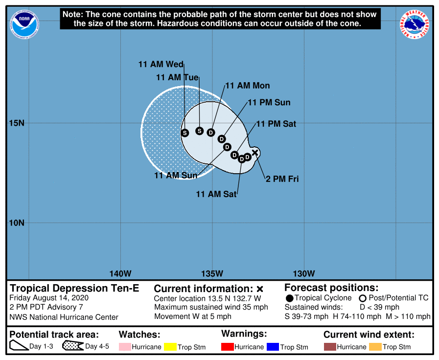
205350_5day_cone_no_line_and_wind.png
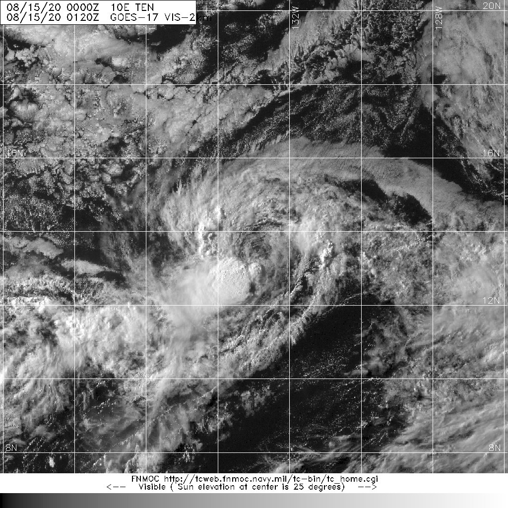
20200815.0120.goes-17.vis.2km.10E.TEN.30kts.1004mb.13.4N.133W.pc.jpg
回復

使用道具 舉報

12下一頁
快速回覆
您需要登錄後才可以回帖 登錄 | 立即加入

本版積分規則

本平台僅供學術討論之用,預報應以氣象局為準

威普網站虛擬主機贊助公司

臺灣第一個天氣類型社群平台 即時天氣資訊、精準颱風動態

線上客服
FB傳送訊息
廣告行銷
精準行銷 物超所值
官方粉專
發佈 快速回復 返回頂部 返回列表