開啟輔助訪問
 找回密碼
 立即加入

09L.Isaias 實測達C1 橫掃美國東岸

簽到天數: 1650 天

[LV.Master]伴壇終老

2020-7-25 03:30 | 顯示全部樓層
本帖最後由 老農民版夜神月 於 2020-8-4 18:36 編輯

  基本資料  
編號    :92 L
擾動編號日期:2020 07 24 02
撤編日期  :2020 07 00 00
92L INVEST 200724 1800 11.1N 21.5W ATL 20 1010

032058htkjemqtuzuvk1kj.jpeg

  NHC:0%
1. A tropical wave located about 300 miles south-southeast of the Cabo
Verde Islands continues to produced an area of cloudiness and
disorganized showers and thunderstorms. The disturbance is expected
move westward across the tropical Atlantic during the next several
days, and some gradual development of this system is possible by
early next week when it reaches the western tropical Atlantic.
* Formation chance through 48 hours...low...near 0 percent.
* Formation chance through 5 days...medium...40 percent.


two_atl_2d1 (3).png
two_atl_5d1 (3).png

評分

參與人數 1水氣能量 +15 +1 收起 理由
周子堯@FB + 15 + 1

查看全部評分

回復

使用道具 舉報

簽到天數: 1650 天

[LV.Master]伴壇終老

老農民版夜神月|2020-7-26 08:52 | 顯示全部樓層
本帖最後由 老農民版夜神月 於 2020-7-26 09:43 編輯

NHC於00Z將展望一舉提升至Medium,50%/80%
1. A broad area of low pressure associated with a tropical wave located
several hundred miles west-southwest of the Cabo Verde Islands is
producing a large area of cloudiness and disorganized showers and
thunderstorms.  Environmental conditions appear conducive for
development, and a tropical depression is likely to form early next
week while the wave moves westward at around 15 mph across the
tropical Atlantic.
* Formation chance through 48 hours...medium...50 percent.
* Formation chance through 5 days...high...80 percent.

two_atl_2d1.png two_atl_5d1.png
92L_gefs_latest.png 未命名.png
回復

使用道具 舉報

簽到天數: 601 天

[LV.9]以壇為家II

霧峰追風者|2020-7-27 08:22 | 顯示全部樓層
1. Shower activity is becoming a little better organized in
association with a broad area of low pressure located over the
central tropical Atlantic about midway between the coast of Africa
and the Lesser Antilles.  Environmental conditions are expected to
become increasingly conducive for development of this system, and a
tropical depression or tropical storm is likely to form within the
next day or two while moving westward to west-northwestward at
15 to 20 mph.  This system is expected to begin affecting portions
of the Lesser Antilles on Wednesday or Wednesday night, and
interests on those islands should continue to monitor its progress.
* Formation chance through 48 hours...high...80 percent.
* Formation chance through 5 days...high...90 percent.
two_atl_2d1.png


回復

使用道具 舉報

簽到天數: 1650 天

[LV.Master]伴壇終老

老農民版夜神月|2020-7-27 15:35 | 顯示全部樓層
FWC-N27/0600Z發布TCFA
WTNT21 KNGU 270600
SUBJ/TROPICAL CYCLONE FORMATION ALERT CORRECTED //
REF/A/FLEWEACEN NORFOLK VA/270600Z JUL 20//
AMPN/REF IS TROPICAL CYCLONE FORMATION ALERT (WTNT21 KNGU 270600)//
RMKS/ 1. FORMATION OF A SIGNIFICANT TROPICAL CYCLONE IS POSSIBLE WITHIN
100 NM EITHER SIDE OF A LINE FROM 12.1N 41.2W TO 13.1N 46.9W
WITHIN THE NEXT 24 HOURS. AVAILABLE DATA DOES NOT JUSTIFY
ISSUANCE OF NUMBERED TROPICAL CYCLONE WARNINGS AT THIS TIME.
WINDS IN THE AREA ARE ESTIMATED TO BE 10 TO 15 KNOTS. METSAT
IMAGERY AT 270600Z INDICATES THAT A CIRCULATION CENTER IS LOCATED
NEAR 12.1N 41.7W. THE SYSTEM IS MOVING WEST-NORTHWESTWARD AT 18
KNOTS.
2. REMARKS: MAXIMUM SUSTAINED SURFACE WINDS ARE ESTIMATED
AT 10 TO 15 KNOTS. MINIMUM SEA LEVEL PRESSURE IS ESTIMATED TO BE
NEAR 1010 MB. THE POTENTIAL FOR THE DEVELOPMENT OF A SIGNIFICANT
TROPICAL CYCLONE WITHIN THE NEXT 24 HOURS IS HIGH. THIS SUPERSEDES
REF A. SHOWERS AND THUNDERSTORMS ASSOCIATED WITH AN ELONGATED OF LOW
PRESSURE LOCATED ABOUT MIDWAY BETWEEN THE LESSER ANTILLES AND THE
WEST COAST OF AFRICA IN THE CENTRAL ATLANTIC GRADUALLY CONTINUES
TO BECOME BETTER ORGANIZED. ENVIRONMENTAL CONDITIONS IN THE
CENTRAL ATLANTIC ARE CONDUCIVE FOR FURTHER DEVELOPMENT OF THE
SYSTEM AND A TROPICAL DEPRESSION OR STORM IS LIKELY TO FORM
WITHIN THE NEXT 24 HOURS WHILE IT MOVES GENERALLY WEST-
NORTHWESTWARD AT 10-15 KNOTS.
3. THIS ALERT WILL BE REISSUED, UPGRADED TO WARNING OR CANCELLED BY 280600Z.//

al922020.20200727070443.gif 20200727.0700.goes-16.ir.92L.INVEST.25kts.1010mb.11.9N.40.3W.100pc.jpg
20200727.0425.gw1.89pct89h89v.92L.INVEST.25kts.1010mb.11.9N.40.3W.93pc.jpg 92L_intensity_latest.png
回復

使用道具 舉報

簽到天數: 601 天

[LV.9]以壇為家II

霧峰追風者|2020-7-28 23:07 | 顯示全部樓層
000
WTNT44 KNHC 281458
TCDAT4

Potential Tropical Cyclone Nine Discussion Number   1
NWS National Hurricane Center Miami FL       AL092020
1100 AM AST Tue Jul 28 2020

Shower and thunderstorm activity has increased overnight and this
morning in association with a broad area of low pressure located
several hundred miles east of the Lesser Antilles.  Recent visible
satellite imagery and ASCAT data show that the system's circulation
is quite elongated and lacks a well-defined center. Observations
from NOAA buoy 41040 and ASCAT suggest that the system is
already producing winds of 30-35 kt, and the systems's initial
intensity has been set to 35 kt. Dry air located just to the north
of the system has been hindering development over the past couple of
days, but environmental conditions are expected to be more conducive
for development over the next couple of days. Therefore, the system
is likely to become a tropical storm before it reaches the Leeward
Islands and advisories are being initiated in order to issue
Tropical Storm Warnings for a portion of the Leeward Islands, the
U.S. and British Virgin Islands, and Puerto Rico. A U.S. Air Force
Reserve reconnaissance aircraft is scheduled to investigate the
system early this afternoon, and should provide additional
information on the intensity and structure of the low pressure
area.

It cannot be stressed enough that since the system is still in the
formative stage, greater than average uncertainty exists regarding
both the short-term and longer-term track and intensity forecasts.  
A subtropical ridge that extends westward from the central Atlantic
is expected to be the dominant steering mechanism over the next
several days, and the flow around this ridge should steer the low
pressure area generally west-northwestward.  However, the details in
the track forecast could change depending on exactly where within
elongated circulation the center forms.  Regardless of the exact
track, the system is expected to bring locally heavy rainfall to
much of the Lesser Antilles, and tropical-storm-force winds to
portions of the Leeward Islands, the Virgin Islands, and Puerto Rico
within the next 24-48 hours.  After that time, a general west-
northwestward heading should continue but as mentioned before,
uncertainty exists as to how close the system tracks to  
Hispaniola, Cuba, the Bahamas, and Florida. The NHC track forecast
is in best agreement with the HFIP corrected consensus model.  It
should be noted that a stronger cyclone is likely to favor a more
northern track, while a weaker system is likely to remain more
equatorward.  Users should remember that the long-term average NHC
track forecast errors at days 4 and 5 are 140 and 175 n mi,
respectively.

Given the current structure of the system, only gradual
strengthening is predicted during the next day or two, however the
system is expected to become a tropical storm when it is near the
Leeward Islands on Wednesday.  After 48 hours, possible land
interaction with the Greater Antilles, and increasing south to
southwesterly shear from an upper-level trough could temper further
strengthening. The global models generally weaken the system due to
these negative factors and the NHC forecast calls for little change
in strength at the longer range.  Interests in Hispaniola, the
Bahamas, Cuba, and Florida should continue to monitor forecasts as
changes to both track and intensity are likely.

Key Messages:

1. Potential Tropical Cyclone Nine will produce heavy rains and
potentially life-threatening flash flooding and mudslides across
the northern Leeward Islands, the Virgin Islands and Puerto Rico.

2. Tropical storm conditions are likely across portions of the
Leeward Islands, the Virgin Islands, and Puerto Rico Wednesday
through Thursday, and Tropical Storm Warnings are in effect.
Do not focus on the details of the track forecast, as rainfall and
wind hazards will extend far from the center of the system.

3. The details of the long-range track and intensity forecasts are
more uncertain than usual since the system does not have a
well-defined center and could move over portions of the Greater
Antilles later this week. However, this system could bring some
rainfall and wind impacts to portions of Hispaniola, Cuba, the
Bahamas, and Florida by the end of the week. Interests there should
monitor its progress and updates to the forecast over the next few
days.

FORECAST POSITIONS AND MAX WINDS

INIT  28/1500Z 13.8N  53.7W   35 KT  40 MPH...POTENTIAL TROP CYCLONE
12H  29/0000Z 14.8N  56.7W   35 KT  40 MPH...POTENTIAL TROP CYCLONE
24H  29/1200Z 16.0N  60.4W   40 KT  45 MPH...TROPICAL STORM
36H  30/0000Z 17.3N  64.0W   45 KT  50 MPH
48H  30/1200Z 18.8N  67.6W   50 KT  60 MPH
60H  31/0000Z 20.1N  70.7W   50 KT  60 MPH
72H  31/1200Z 21.3N  73.5W   50 KT  60 MPH
96H  01/1200Z 24.1N  77.9W   50 KT  60 MPH
120H  02/1200Z 26.8N  80.6W   45 KT  50 MPH...INLAND

$$
Forecaster Brown
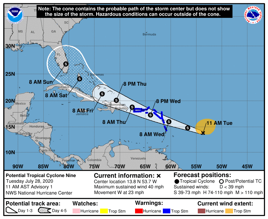
150024_5day_cone_no_line_and_wind.png
回復

使用道具 舉報

簽到天數: 1650 天

[LV.Master]伴壇終老

老農民版夜神月|2020-7-28 23:43 | 顯示全部樓層
NHC新報雖升格其為09L,並定強35KT,但認定目前的09L(升格前編號為92L)尚屬於PTC(潛在熱帶氣旋),因此09L尚未獲得命名
此系統將在兩三日內逐漸進逼,威脅大安地列斯群島
92L INVEST 200728 1200 13.5N 52.8W ATL 35 1007
AL, 09, 2020072812, , BEST, 0, 135N, 528W, 35, 1007, DB
20200728.1430.goes-16.vis.2km.92L.INVEST.35kts.1007mb.13.5N.52.8W.pc.jpg 20200728.0959.f17.91h.92L.INVEST.25kts.1008mb.13.1N.50.2W.095pc.jpg
20200728.1430.goes-16.irbd.92L.INVEST.35kts.1007mb.13.5N.52.8W.100pc.jpg 20200728.0959.f17.91pct91h91v.92L.INVEST.25kts.1008mb.13.1N.50.2W.095pc.jpg
回復

使用道具 舉報

簽到天數: 601 天

[LV.9]以壇為家II

霧峰追風者|2020-7-30 11:09 | 顯示全部樓層
991
WTNT44 KNHC 300301
TCDAT4

Tropical Storm Isaias Discussion Number   7
NWS National Hurricane Center Miami FL       AL092020
1100 PM AST Wed Jul 29 2020

Observations from recent scatterometer passes over the system show
that it now has a sufficiently well-defined center to be
designated as a tropical cyclone.  The current intensity is
estimated to be 45 kt, but these winds are currently occurring over
the Atlantic waters well to the north and northeast of the center.  
Since the cyclone is expected to move over Hispaniola on Thursday
some weakening is likely within the next 24 hours.  However since
Isaias has such a broad wind field, the weakening will probably not
be as significant as in a typical tropical cyclone with a small
radius of maximum winds.  Also, a re-formation of the center to the
north of Hispaniola may occur.  Later in the forecast period some
strengthening is likely, although this may be offset by
southwesterly wind shear on the order of 20 kt in 2-3 days.  The
official forecast is close to the intensity model consensus but
well below the latest LGEM guidance.

The scatterometer data show that the center of the system is south
of the previously estimated track, so there is a lot of uncertainty
in the initial motion estimate of 285/17 kt.  Isaias should move on
a west-northwestward to northwestward track on the southern and
southwestern side of a mid-tropospheric ridge.  In 2-3 days,
the system is expected to turn north-northwestward due to a
weakness in the ridge and an approaching trough.  Later in the
forecast period, the trough should cause Isaias to turn toward the
northeast.  The official track forecast is a little to the east of
the previous one and a little west of the simple and corrected
dynamical model consensus tracks.  It should be noted that further
adjustments to the forecast tracks are indeed possible, especially
after Isaias moves north of Hispaniola.


Key Messages:

1. Isaias will produce heavy rains and potentially life-threatening
flash flooding and mudslides across the Virgin Islands, Puerto Rico,
the Dominican Republic, northern Haiti, and over the southeastern
Bahamas.

2. Tropical storm conditions are likely across portions of the
the Virgin Islands, and Puerto Rico through tonight and will spread
westward to portions of the Dominican Republic, Haiti, and the
southeastern Bahamas and Turks and Caicos and the Central Bahamas
on Thursday and Friday.  Tropical Storm Warnings are in effect for
these areas. Do not focus on the details of the track forecast, as
rainfall and wind hazards will extend far from the center of the
system.

3. While this system could bring some rainfall and wind impacts to
portions of Cuba, the northwestern Bahamas, and Florida later this
week and this weekend, it is too soon to determine the location or
magnitude of those impacts.  Interests there should monitor the
progress of this system and updates to the forecast over the next
few days.


FORECAST POSITIONS AND MAX WINDS

INIT  30/0300Z 15.8N  67.0W   45 KT  50 MPH
12H  30/1200Z 17.6N  69.3W   45 KT  50 MPH
24H  31/0000Z 19.4N  72.2W   40 KT  45 MPH...INLAND
36H  31/1200Z 21.4N  74.8W   45 KT  50 MPH...OVER WATER
48H  01/0000Z 22.9N  77.3W   50 KT  60 MPH
60H  01/1200Z 24.8N  79.2W   55 KT  65 MPH
72H  02/0000Z 26.6N  80.2W   55 KT  65 MPH...INLAND
96H  03/0000Z 30.0N  80.5W   55 KT  65 MPH...INLAND
120H  04/0000Z 35.0N  77.0W   50 KT  60 MPH...INLAND

$$
Forecaster Pasch
025120_5day_cone_no_line_and_wind.png
回復

使用道具 舉報

簽到天數: 1650 天

[LV.Master]伴壇終老

老農民版夜神月|2020-7-30 14:05 | 顯示全部樓層
本帖最後由 老農民版夜神月 於 2020-7-30 14:08 編輯

補上一些09L命名前後的風場掃描及雲圖、動圖
20200730.0520.goes-16.ir.09L.ISAIAS.45kts.1004mb.15.7N.66.3W.100pc.jpg 20200729.2238.f17.composite.09L.NINE.40kts.1006mb.16.1N.64.9W.090pc.jpg
LATEST (7).jpg goes16_ir_09L_202007300325.gif
回復

使用道具 舉報

12下一頁
快速回覆
您需要登錄後才可以回帖 登錄 | 立即加入

本版積分規則

本平台僅供學術討論之用,預報應以氣象局為準

威普網站虛擬主機贊助公司

臺灣第一個天氣類型社群平台 即時天氣資訊、精準颱風動態

線上客服
FB傳送訊息
廣告行銷
精準行銷 物超所值
官方粉專
發佈 快速回復 返回頂部 返回列表