簽到天數: 1765 天 [LV.Master]伴壇終老
|
 zjk369|2018-11-18 21:15
|
顯示全部樓層

- TROPICAL DEPRESSION 33W (SAMUEL) UPDATE NO. 01
- Issued at: 7:00 PM PhT (11:00 GMT) Sunday, 18 November 2018
- Next update: 7:00 AM PhT (23:00 GMT) Monday, 19 November 2018
- Current Status and Outlook
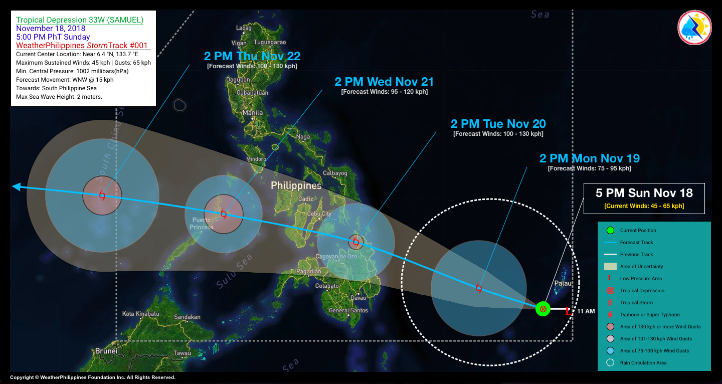
- Tropical Depression (TD) 33W [SAMUEL] newly-formed over the southeastern part of the South Philippine Sea, has entered the Philippine Area of Responsibility (PAR) early this afternoon. This system is now posing a threat to Northeastern Mindanao-Visayas-Sulu-Palawan Area…could traverse these areas beginning Tuesday afternoon (Nov 20) through Wednesday evening (Nov 21).
- 24-hr Outlook: TD 33W (SAMUEL) will continue to intensify while moving west-northwest towards the central part of the South Philippine Sea at a forward speed of 15 km/hr. It could become a Tropical Storm (TS) by tomorrow, Monday afternoon.
- This depression is still far to directly affect any part of the Philippines within the next 24 hours. It will therefore enhance the Northeast Monsoon (Amihan) and could bring occasional rain showers and thunderstorms across the Bicol and Quezon Provinces beginning Monday evening.
- Where is 33W (SAMUEL)?As of 5:00 PM PhT today, November 18…0900 GMT. The center was located over the southeasternmost part of the South Philippine Sea (near 6.4°N 133.7°E), about 825 km east of Mati City, Davao Oriental or 884 km east-southeast of Tandag City, Surigao Del Sur.
- How strong is it?
- Maximum Sustained Winds (10-min avg): 45 kph near the center…Gustiness: 65 kph.
- Past Movement (06 hrs) Westward @ 22 kph, towards the Central Part of the South Philippine Sea.
- Potential Philippine Landfall Area(s) :: Along the Eastern part of Surigao Del Sur, between 10 AM to 12 PM local time on Tuesday, Nov 20 – with Medium Strike Probability of 50-60%.
- What Philippine areas will be directly affected? Moderate to Extreme Rains (30 to more than 100 mm expected):
- >> Caraga Region, Northern Davao Region, Northern Mindanao, & Eastern Visayas – beginning Monday (Nov 19).
- >> Central and Western Visayas, Zamboanga Del Norte, Sulu Archipelago, & Palawan – beginning Tuesday (Nov 20).
- Damaging Winds (gusts of more than 100 km/hr expected):
- >> None.
- Potential Storm Surge/Coastal Flooding Areas+ :: None.
- +Waves of 3 meters in height is expected in storm surge-prone areas, particularly in coastal areas on where the Tropical Cyclone is headed. Kindly visit the PAGASA Storm Surge Updates for more details.
- 4-Day Forecast Outlook Summary**
- MONDAY AFTERNOON: Intensifies into a minimal Tropical Storm (TS) as it moves WNW-ward across the central portion of the South Philippine Sea…about 515 km east of Mati City, Davao Oriental [2PM Nov 19: 7.3°N 130.9°E @ 75kph]. Confidence Level: LOW.
- TUESDAY AFTERNOON: In the vicinity of Northern Agusan Del Norte, after making landfall over the Town of Cortes, Surigao Del Sur…reaches Severe Tropical Storm (TS) classification…about 39 km north of Butuan City, Agusan Del Norte [2PM Nov 20: 9.3°N 125.5°E @ 100kph]. Confidence Level: LOW.
- WEDNESDAY AFTERNOON: In the vicinity of Santa Teresita, Palawan as it weakens slightly while turning westward traversing Northern Palawan…about 116 km east-northeast of Puerto Princesa City, Palawan [2PM Nov 21: 10.5°N 119.7°E @ 95kph]. Confidence Level: LOW.
- THURSDAY AFTERNOON: Exits the southwestern border of the PAR, as it re-intensifies while moving west-northwest towards the South China Sea…about 502 km west-northwest of Puerto Princesa City, Palawan [2PM Nov 22: 11.3°N 114.4°E @ 100kph]. Confidence Level: LOW.
- **Important Note: Please be reminded that the Forecast Outlook changes every 6 hours, and the Day 2 and 3 Forecast Track have an average error of 100 and 250 km respectively… while the wind speed forecast error, averages 35 km/have per day. Therefore, a turn to the left or right of its future track and changes in its wind speed must be anticipated from time to time.
- Other Storm Info > 24 hr. Rain Accumulation (across its circulation): 25 to 250 mm [Light to Heavy]
- > Minimum Central Pressure: 1002 millibars (hPa)
- > Size of Circulation [Convective Cloud-Based, in diameter]: 675 km (Medium)
- > Area of Damaging Winds (100 kph or more wind gusts): None.
- Additional Information Time/Date: 5:00 PM PhT Sun November 18, 2018
- Location of Center/Eye: Near 6.4°N Lat 133.7°E Lon
- Distance 1: 879 km East of Tagum City, Davao Del Norte
- Distance 2: 915 km ENE of Davao City, Davao Del Norte
- Distance 3: 943 km ESE of Butuan City, Agusan Del Norte
- Distance 4: 949 km ESE of Cabadbaran City, Agusan Del Norte
- Distance 5: 1653 km ESE of Metro Manila, PH
- 24 hr. Forecast Coordinates (Class): 7.3°N 130.9°E (TS)
- 48 hr. Forecast Coordinates (Class): 9.3°N 125.5°E (STS)
- 72 hr. Forecast Coordinates (Class): 10.5°N 119.7°E (STS)
- 96 hr. Forecast Coordinates (Class): 11.3°N 114.4°E (STS)
|
|