開啟輔助訪問
 找回密碼
 立即加入

16E.Norman 三度站上MH

簽到天數: 3291 天

[LV.Master]伴壇終老

t02436|2018-9-4 20:21 | 顯示全部樓層
進入中太,09Z轉交CPHC發報,將在西經150度附近北轉,不會影響夏威夷。
WTPA44 PHFO 040856
TCDCP4

Hurricane Norman Discussion Number  29
NWS Central Pacific Hurricane Center Honolulu HI   EP162018
1100 PM HST Mon Sep 03 2018

Norman continues to weaken this evening. The final visible
satellite images of the day showed a cloud-filled eye, and cloud
tops have warmed further during the past several hours. Subjective
Dvorak current intensity estimates came in at 4.5/77 kt from PHFO,
and 4.0/65 kt from SAB/JTWC, while the latest CIMSS ADT estimate is
4.2/70 kt. A blend of these estimates supports lowering the initial
intensity to 75 kt for this advisory.

The hurricane has turned slightly to an almost due west track this
evening, and it appears that the anticipated decrease in forward
speed has begun. The initial motion estimate is 275/15 kt, which is
a few knots slower than the previous advisory. Westward motion with
a further decrease in forward speed is expected to continue through
the next 36 hours as Norman nears the southwestern periphery of a
strong subtropical ridge centered to the northeast. Thereafter, the
cyclone will gradually turn to the west-northwest then to the
northwest as it moves around the end of the ridge and is
increasingly steered by a large deep-layered trough over the North
Pacific. Most of the reliable guidance has come into better
agreement with the location and timing of this turn. The consensus
guidance HCCA, TVCE and FSSE are tightly packed and in good
agreement with the previous official forecast through 48 hours, then
shift slightly to the right thereafter. The new official forecast is
very similar to the previous forecast, and generally lies very close
to the consensus aids in the middle of the guidance envelope.

The CIMSS initial vertical wind shear estimate was 10 kt, and SHIPS
guidance shows light shear continuing for another 48 hours as
Norman continues tracking around the subtropical ridge. The main
issue causing weakening for the hurricane at present appears to be
marginal sea surface temperatures and ocean heat content. CIRA
analysis shows that Norman should move into an area of slightly more
favorable OHC after about 12 more hours, and the guidance shows
intensity flattening out from 12 through 48 hours. Norman may
actually re-intensity a bit during that time period, but opted to
keep the intensity forecast level at 70 kt for this advisory.
Thereafter, a rapid increase in wind shear, a drier surrounding
airmass, and progressively cooler sea surface temperatures should
cause steady weakening. The new intensity forecast is similar to
the previous, and in good agreement with the consensus aids.


FORECAST POSITIONS AND MAX WINDS

INIT  04/0900Z 19.9N 141.7W   75 KT  85 MPH
12H  04/1800Z 20.0N 143.7W   70 KT  80 MPH
24H  05/0600Z 20.0N 145.9W   70 KT  80 MPH
36H  05/1800Z 20.3N 147.8W   70 KT  80 MPH
48H  06/0600Z 20.9N 149.2W   70 KT  80 MPH
72H  07/0600Z 23.3N 151.3W   60 KT  70 MPH
96H  08/0600Z 26.0N 153.5W   45 KT  50 MPH
120H  09/0600Z 29.0N 155.0W   30 KT  35 MPH

$$
Forecaster Jacobson

EP162018_5day_cone_with_line_29.png

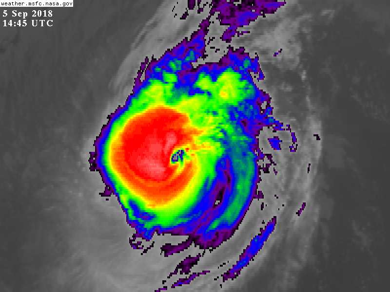
LATEST.jpg

rbtop-animated.gif
回復

使用道具 舉報

簽到天數: 3291 天

[LV.Master]伴壇終老

t02436|2018-9-5 23:15 | 顯示全部樓層
頑強的生命力,15Z第三度站上MH!
WTPA44 PHFO 051500
TCDCP4

Hurricane Norman Discussion Number  34
NWS Central Pacific Hurricane Center Honolulu HI   EP162018
500 AM HST Wed Sep 05 2018

Norman appears to have rapidly intensified overnight. Although
the eye has become slightly less distinct during the past couple of
hours, the satellite fix agencies (SAB, JTWC, and PHFO) were in
unanimous agreement that the subjective Dvorak current intensity
estimate was 5.5/102 kt. In addition, the most recent UW-CIMSS
ADT estimate was 5.8/110 kt. Based on these estimates, we have
increased the initial intensity to 100 kt for this advisory.

Norman has been moving just south of due west, or 265 deg, at 10 kt.
It is being steered by a deep subtropical ridge located to the north
and northeast. The western edge of this ridge is forecast to erode
later today as an upper-level trough digs down toward the region
north of the Hawaiian Islands during the next couple of days. As a
result, the forecast guidance is showing an increasing spread in the
track forecasts starting in 48 hours. This is likely due to the way
the different models forecast the weakening of the western flank of
the ridge due to the upper-level trough. This weakening of the
ridge is expected to cause Norman to slow its forward motion and
gradually turn toward the west-northwest starting later today. This
will likely be followed by a turn toward the northwest starting
later tonight or early Thursday, and continuing into this weekend.
The latest forecast track has been shifted to the left of the
previous forecast, and remains close to the middle of the guidance
envelope through the next 2 days. Even though the guidance spread
increases during days 3 through 5, all of the models support the
general northwestward motion persisting. The latest official
forecast is also very close to the FSSE, TVCE, HCCA and GFEX
consensus model guidance.

Norman is expected to remain a hurricane for the next couple of
days. The latest CIRA ocean heat content (OHC) analysis appears to
support it remaining near major hurricane intensity today. Vertical
wind shear has gradually increased to near 15 kt based on the
latest UW-CIMSS estimate, which may be contributing to some of the
degradation of the eye this morning. By tonight, most of the
guidance is in good agreement that Norman will start to weaken under
the effects of increasing southwesterly vertical wind shear, cooler
SSTs, and drier environmental conditions. This weakening will likely
persist through day 5, when Norman is forecast to become a remnant
low. The intensity forecast follows similar trends of the prior
advisory, and favors the latest ICON guidance.

The NOAA Gulfstream IV aircraft is scheduled to conduct another
mission to sample the environment around Norman later today. The
valuable data collected during this mission will be used to improve
the initialization of the various hurricane forecast models that we
use to predict the motion and intensity of Norman later today and
tonight.


FORECAST POSITIONS AND MAX WINDS

INIT  05/1500Z 19.5N 147.7W  100 KT 115 MPH
12H  06/0000Z 19.8N 148.9W  100 KT 115 MPH
24H  06/1200Z 20.4N 150.2W   90 KT 105 MPH
36H  07/0000Z 21.4N 151.3W   80 KT  90 MPH
48H  07/1200Z 22.6N 152.3W   70 KT  80 MPH
72H  08/1200Z 24.9N 154.3W   45 KT  50 MPH
96H  09/1200Z 27.0N 156.5W   30 KT  35 MPH
120H  10/1200Z 28.6N 158.0W   25 KT  30 MPH...POST-TROP/REMNT LOW

$$
Forecaster Houston
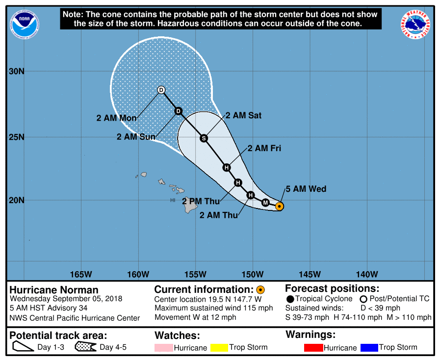
EP162018_5day_cone_with_line_34.png

GOES14452018248ZOfj7O.jpg

16E NORMAN 180905 1200 19.5N 147.2W EPAC 100 962
16E NORMAN 180905 0600 19.6N 146.1W EPAC 80 978
16E NORMAN 180905 0000 19.8N 145.1W EPAC 70 984
16E NORMAN 180904 1800 19.8N 143.9W EPAC 70 984
16E NORMAN 180904 1200 19.8N 142.6W EPAC 75 982
16E NORMAN 180904 0600 19.8N 141.0W EPAC 75 982
16E NORMAN 180904 0000 19.7N 139.4W EPAC 85 975
16E NORMAN 180903 1800 19.4N 137.6W EPAC 90 971
16E NORMAN 180903 1200 19.1N 135.7W EPAC 100 964
16E NORMAN 180903 0600 18.8N 133.7W EPAC 110 955
16E NORMAN 180903 0000 18.4N 131.8W EPAC 115 950
16E NORMAN 180902 1800 17.9N 130.0W EPAC 115 948
16E NORMAN 180902 1200 17.4N 128.3W EPAC 115 948

16E NORMAN 180902 0600 16.9N 126.7W EPAC 90 970
16E NORMAN 180902 0000 16.5N 125.5W EPAC 85 973
16E NORMAN 180901 1800 16.2N 124.5W EPAC 90 970
16E NORMAN 180901 1200 16.2N 123.3W EPAC 90 970
16E NORMAN 180901 0600 16.3N 122.5W EPAC 95 966
16E NORMAN 180901 0000 16.4N 121.8W EPAC 105 958
16E NORMAN 180831 1800 16.6N 121.1W EPAC 110 954
16E NORMAN 180831 1200 16.8N 120.4W EPAC 115 950
16E NORMAN 180831 0600 17.1N 119.9W EPAC 125 942
16E NORMAN 180831 0000 17.4N 119.2W EPAC 130 937
16E NORMAN 180830 1800 17.6N 118.4W EPAC 130 937
16E NORMAN 180830 1200 17.7N 117.6W EPAC 125 942

16E NORMAN 180830 0600 17.8N 117.0W EPAC 95 968
16E NORMAN 180830 0000 17.8N 116.3W EPAC 70 986
16E NORMAN 180829 1800 17.7N 115.7W EPAC 65 987
16E NORMAN 180829 1200 17.6N 115.1W EPAC 55 994
16E NORMAN 180829 0600 17.4N 114.2W EPAC 50 999
16E NORMAN 180829 0000 17.4N 113.4W EPAC 45 1000

回復

使用道具 舉報

簽到天數: 3291 天

[LV.Master]伴壇終老

t02436|2018-9-9 18:38 | 顯示全部樓層
補充一下
CPHC昨天21Z發出最後一報,現已轉化。
WTPA44 PHFO 082123
TCDCP4

Tropical Storm Norman Discussion Number  47...RESENT
NWS Central Pacific Hurricane Center Honolulu HI   EP162018
1100 AM HST Sat Sep 08 2018

Norman is quickly losing the characteristics of a tropical cyclone
as strong vertical wind shear is taking its toll. The low-level
circulation center (LLCC) has been exposed for the better part of a
day now, with sporadic deep convection in the northern semicircle
remaining well removed from the center. Visible satellite imagery
shows the LLCC becoming increasingly elongated, now marked by a 90
nm X 30 nm wide clear area. Intensity estimates support lowering the
initial intensity to 45 kt for this advisory as Norman continues to
spin down.

The track forecast takes Norman generally toward the north through
day 3 before briefly turning it northwestward before dissipation on
day 5, in line with GFEX. It appears that Norman will still produce
at least gale force winds for the next couple of days as it
interacts with a developing cold-core low to its northwest, with
GFS indicating winds in excess of 50 kt in 24-36 hours. While this
seems a little extreme, the official intensity forecast indicates
little change in intensity through day 2, with gradual weakening
thereafter.

This will be the last advisory issued by CPHC on this system.


FORECAST POSITIONS AND MAX WINDS

INIT  08/2100Z 26.9N 154.6W   45 KT  50 MPH
12H  09/0600Z 28.4N 154.6W   40 KT  45 MPH...POST-TROPICAL
24H  09/1800Z 30.2N 154.4W   40 KT  45 MPH...POST-TROPICAL
36H  10/0600Z 32.0N 154.1W   40 KT  45 MPH...POST-TROPICAL
48H  10/1800Z 33.5N 154.2W   35 KT  40 MPH...POST-TROPICAL
72H  11/1800Z 35.0N 155.5W   30 KT  35 MPH...POST-TROP/REMNT LOW
96H  12/1800Z 35.5N 157.0W   20 KT  25 MPH...POST-TROP/REMNT LOW
120H  13/1800Z...DISSIPATED

$$
Forecaster Birchard

5day_cone_with_line.png

rbtop-animated.gif

P_e_sfc_color.png
回復

使用道具 舉報

12
快速回覆
您需要登錄後才可以回帖 登錄 | 立即加入

本版積分規則

本平台僅供學術討論之用,預報應以氣象局為準

威普網站虛擬主機贊助公司

臺灣第一個天氣類型社群平台 即時天氣資訊、精準颱風動態

線上客服
FB傳送訊息
廣告行銷
精準行銷 物超所值
官方粉專
發佈 快速回復 返回頂部 返回列表