開啟輔助訪問
 找回密碼
 立即加入

16E.Norman 三度站上MH

簽到天數: 601 天

[LV.9]以壇為家II

2018-8-26 09:45 | 顯示全部樓層
  四級颶風  
編號:16 E
名稱:Norman

  基本資料  
擾動編號日期:2018 08 26 07
命名日期  :2018 08 29 11
       2018 09 04 17 - CPHC接續發報
撤編日期  :2018 09 00 00
登陸地點  :

  巔峰時期資料  
近中心最強風速
國家颶風中心(NHC):130 kts
中太平洋颶風中心(CPHC):100 kts
海平面最低氣壓937 百帕

  過去路徑圖  


  擾動編號資料  
90E.INVEST.25kts-1009mb-10.2N-102.4W

20180825.2256.f16.x.vis2km.90EINVEST.25kts-1009mb-102N-1024W.079pc.jpg

  NHC : 20%  
2. A broad low pressure system located about 500 miles south of
Acapulco, Mexico, continues to produce a large area of disorganized
showers and thunderstorms.  Slow development of this system is
expected over the next several days, and a tropical depression could
form by the middle of next week while it moves westward or
west-northwestward at 10 mph.
* Formation chance through 48 hours...low...20 percent.
* Formation chance through 5 days...medium...60 percent.

two_pac_2d2.png

以上資料來自:NHC、CPHC颱風論壇整理製作

評分

參與人數 1水氣能量 +15 +1 收起 理由
king111807 + 15 + 1 熱帶擾動首帖

查看全部評分

回復

使用道具 舉報

簽到天數: 601 天

[LV.9]以壇為家II

霧峰追風者|2018-8-26 19:11 | 顯示全部樓層
NHC 展望提升至40%。
2. A broad low pressure system located about 500 miles south-southwest
of Acapulco, Mexico, is producing a large area of cloudiness and
disorganized showers and thunderstorms. Environmental conditions are
expected to be conducive for gradual development of this disturbance
over the next several days, and a tropical depression is likely to
form by the middle of next week while the system moves westward to
west-northwestward at 10 mph.
* Formation chance through 48 hours...medium...40 percent.
* Formation chance through 5 days...high...80 percent.
two_pac_2d2 (1).png 20180826.0900.goes15.x.ir1km_bw.90EINVEST.25kts-1009mb-110N-1039W.100pc.jpg 90E_gefs_latest.png

回復

使用道具 舉報

簽到天數: 601 天

[LV.9]以壇為家II

霧峰追風者|2018-8-28 13:41 | 顯示全部樓層
NHC 展望提升至90%。
1. Showers and thunderstorms associated with an area of low pressure
located about 500 miles south of the southern tip of the Baja
California peninsula have changed little in organization over the
past several hours. However, environmental conditions are still
favorable for development and a tropical depression is expected to
form tonight or Tuesday while the system moves west-northwest to
northwest at 10 to 15 mph.
* Formation chance through 48 hours...high...90 percent.
* Formation chance through 5 days...high...90 percent.
two_pac_2d1 (1).png rgb-animated (2).gif

回復

使用道具 舉報

簽到天數: 3291 天

[LV.Master]伴壇終老

t02436|2018-8-28 23:34 | 顯示全部樓層
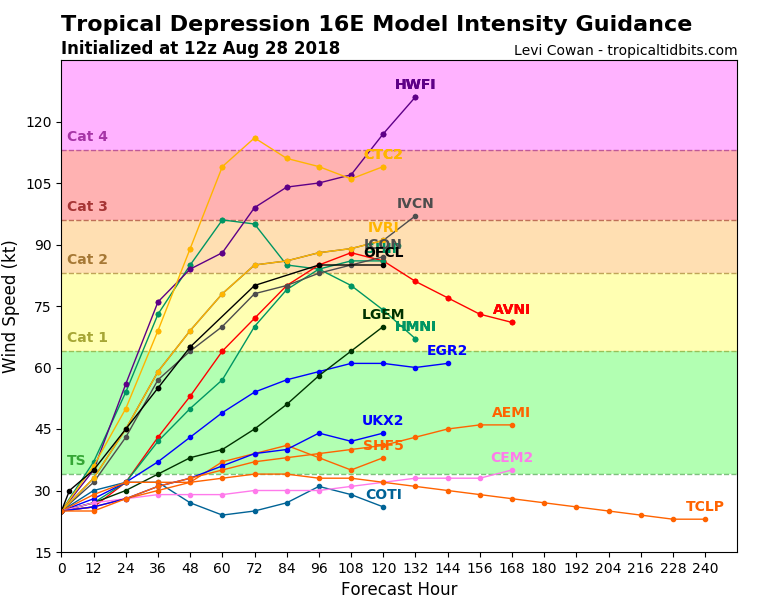
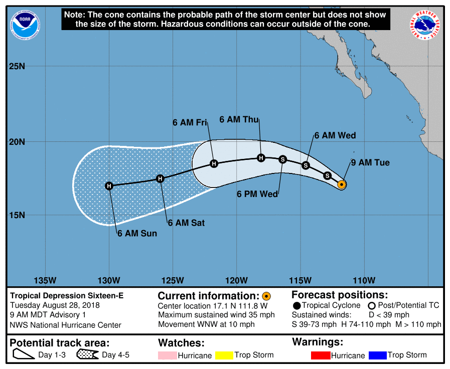
NHC升格16E,將持續西行,暫時上望85節。
968
WTPZ41 KNHC 281440
TCDEP1

Tropical Depression Sixteen-E Discussion Number   1
NWS National Hurricane Center Miami FL       EP162018
900 AM MDT Tue Aug 28 2018

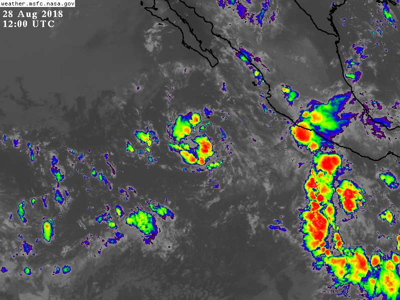
Since the previous scatterometer pass around 0430 UTC, the satellite
presentation has improved significantly. The cloud pattern now
consists of a couple of cyclonically curved convective bands, with
the center of the system located on the northeastern edge of a
circular area of thunderstorms, as indicated by a GMI microwave pass
at 1201 UTC. Satellite intensity estimates from TAFB and SAB are
T2.5 and T2.0, respectively, on the Dvorak scale, and on this basis,
advisories are initiated on Tropical Depression Sixteen-E with an
initial intensity of 30 kt.

The depression has plenty of time to intensify given that the
environmental conditions of warm ocean and light shear are expected
to prevail during the next 5 days. The NHC forecast calls for the
depression to become a hurricane in about 2 days with additional
strengthening thereafter. The forecast is very close to the
intensity consensus model, and follows the trend of most of the
guidance.

Since genesis has just occurred, the initial motion is somewhat
uncertain. The best estimate is toward the west-northwest or 295
degrees at 9 kt. The depression is currently located on the
southwestern edge of a subtropical high, and this flow pattern will
continue to steer the depression on the same general track during
the next day or two. After that time, the nose of the ridge is
expected to amplify, and will force the cyclone to turn toward the
west or even west-southwest. This is very consistent with the track
guidance, and the NHC forecast lies in between the HCCA corrected
consensus model and the other consensus aids.


FORECAST POSITIONS AND MAX WINDS

INIT  28/1500Z 17.1N 111.8W   30 KT  35 MPH
12H  29/0000Z 17.7N 112.9W   35 KT  40 MPH
24H  29/1200Z 18.4N 114.6W   45 KT  50 MPH
36H  30/0000Z 18.8N 116.4W   55 KT  65 MPH
48H  30/1200Z 18.9N 118.1W   65 KT  75 MPH
72H  31/1200Z 18.5N 121.8W   80 KT  90 MPH
96H  01/1200Z 17.5N 126.0W   85 KT 100 MPH
120H  02/1200Z 17.0N 130.0W   85 KT 100 MPH

$$
Forecaster Avila
144530_5day_cone_with_line.png

16E_intensity_latest.png

GOES12002018240jZaUGG.jpg
回復

使用道具 舉報

簽到天數: 2141 天

[LV.Master]伴壇終老

周子堯@FB|2018-8-29 11:29 | 顯示全部樓層
命名"16E Norman",巔峰上望110kt
WTPZ41 KNHC 290236
TCDEP1

Tropical Storm Norman Discussion Number   3
NWS National Hurricane Center Miami FL       EP162018
900 PM MDT Tue Aug 28 2018

The tropical cyclone has become significantly better organized over
the past several hours.  A band of very cold-topped convection now
spirals well over halfway around the circulation.  Dvorak T-numbers
from both TAFB and SAB are up to 3.0, which corresponds to a
current intensity of 45 kt.  On this basis the system is being
upgraded to a tropical storm, making Norman the fourteenth named
tropical cyclone of this busy eastern North Pacific hurricane
season.  Since Norman will continue to move over warm waters and
through an environment of low vertical shear and moist mid-level
air, continued strengthening is likely.  In fact, the various Rapid
Intensification (RI) Indices show high probabilities of RI.
Therefore the official forecast shows intensity changes of 30 and 35
kt per day from 0-24 hours and 24-48 hours respectively.  This is
also close to the simple intensity consensus but below the HFIP
Corrected Consensus and the latest HWRF model run.

The most recent geostationary and microwave satellite center fixes
indicate that Norman is located a little south and southwest of the
previous track, but the initial motion estimate remains about the
same as before, 290/9 kt.  The cyclone is moving along the southern
periphery of a large mid-level ridge which is expanding westward.
This should cause the system to turn toward the west very soon.
Later in the period, the ridge builds a little to the southwest and
this will likely cause Norman to turn toward the west-southwest.
The official track forecast is a little south of the previous one,
but close to the latest simple and corrected model consensus
predictions.

FORECAST POSITIONS AND MAX WINDS

INIT  29/0300Z 17.5N 113.9W   45 KT  50 MPH
12H  29/1200Z 17.9N 115.2W   60 KT  70 MPH
24H  30/0000Z 18.2N 117.0W   75 KT  85 MPH
36H  30/1200Z 18.3N 118.6W   90 KT 105 MPH
48H  31/0000Z 18.1N 120.3W  110 KT 125 MPH
72H  01/0000Z 17.2N 124.1W  110 KT 125 MPH
96H  02/0000Z 16.0N 128.0W  100 KT 115 MPH
120H  03/0000Z 16.0N 132.0W   90 KT 105 MPH
79_105061_2c03d23cc653795.png
20180829.0031.goes-15.vis.1km.16E.NORMAN.45kts.1000mb.17.4N.113.4W.100pc.jpg


回復

使用道具 舉報

簽到天數: 3291 天

[LV.Master]伴壇終老

t02436|2018-8-30 11:24 | 顯示全部樓層
強度已達75節,持續增強,預測兩天以內會達顛峰
848
WTPZ41 KNHC 300236
TCDEP1

Hurricane Norman Discussion Number   7
NWS National Hurricane Center Miami FL       EP162018
800 PM PDT Wed Aug 29 2018

Norman is steadily strengthening.  Recent microwave images indicate
that the hurricane now has a well-defined inner core with a banded
eye feature evident in that data.  The eye is not yet apparent in
geostationary images, but the convective pattern is improving in
organization and the cloud tops continue to become colder.  A blend
of the satellite intensity estimates at 0000 UTC supported an
initial intensity of 70 kt, and since the system continues to
become better organized, the initial wind speed for this advisory is
increased to 75 kt.  Now that Norman has an inner core, rapid
intensification is expected during the next 24 hours or so while the
hurricane remains in near ideal environmental conditions.  The SHIPS
rapid intensification indices are very high, and the NHC intensity
forecast remains near the upper end of the model guidance in the
short term.  Beyond a couple of days, an increase in shear
and slightly cooler waters should promote a gradual weakening trend.

Satellite images suggest that the forward speed of Norman has
slowed to 280/7 kt.  All of the models show a mid-level ridge
amplifying to the north of the tropical cyclone during the next few
days, and this should cause the hurricane to move westward or
west-southwestward during that time.  Thereafter, a turn back to the
west and then west-northwest with an increase in forward speed is
predicted as Norman moves closer to the western periphery of the
ridge.  The model guidance remains in fairly good agreement, and
the NHC track forecast lies near the various consensus aids.

FORECAST POSITIONS AND MAX WINDS

INIT  30/0300Z 17.9N 116.5W   75 KT  85 MPH
12H  30/1200Z 18.0N 117.6W   95 KT 110 MPH
24H  31/0000Z 18.0N 119.2W  105 KT 120 MPH
36H  31/1200Z 17.5N 120.8W  115 KT 130 MPH
48H  01/0000Z 16.8N 122.5W  110 KT 125 MPH
72H  02/0000Z 16.0N 126.3W  105 KT 120 MPH
96H  03/0000Z 16.9N 130.9W   95 KT 110 MPH
120H  04/0000Z 18.5N 136.0W   80 KT  90 MPH

$$
Forecaster Cangialosi

023842_5day_cone_with_line.png

GOES02452018242HhouGP.jpg
回復

使用道具 舉報

簽到天數: 3291 天

[LV.Master]伴壇終老

t02436|2018-8-30 23:39 | 顯示全部樓層
15Z直接爆發到130節!上望140節
是自2015年Patricia增強最快,也是東太今年風季至今最強。
951
WTPZ41 KNHC 301447
TCDEP1

Hurricane Norman Discussion Number  10
NWS National Hurricane Center Miami FL       EP162018
800 AM PDT Thu Aug 30 2018

Norman has rapidly strengthened during the past 12 to 24 hours,
with the development of a well-defined 20-nmi-wide eye and a thick
ring of cold cloud tops of -70 to -85C.  Dvorak constraints have
limited the amount of increase in the subjective and objective final
T-numbers, but the most recent raw data T-numbers are between T6.5
and T7.2, which yields an initial intensity estimate of 130 kt.
Norman's intensity has increased an estimated 70 kt from 1200 UTC
yesterday morning to 1200 UTC this morning- the fastest in the
basin since Patricia in 2015.  Norman has become the 5th category 4
hurricane in the eastern Pacific in 2018 and is also the strongest
hurricane in the basin so far this season.


The hurricane remains in a low-shear environment and will continue
to move over very warm waters of 29-30 degrees Celsius for another
24 hours.  These conditions are expected to allow for additional
strengthening and Norman is forecast to become a category 5
hurricane later today.  Eyewall replacement cycles are likely after
that time, which are difficult to predict, and should cause some
fluctuations in intensity during the next couple of days. Later in
the period, gradually decreasing sea surface temperatures and a
slight increase in shear are forecast to cause gradual weakening.
However, Norman is predicted to remain a hurricane throughout the
5-day forecast period.

Norman is moving westward or 270/7 kt. A strong subtropical ridge
that extends from the Baja California peninsula west-southwestward
into the eastern Pacific is expected to turn Norman
west-southwestward later today or tonight, with this motion
continuing over the next couple of days.  The global models shift
the orientation of the ridge in a few days which should cause
Norman to turn west-northwestward by early next week.  The
dynamical model guidance is tightly clustered, and the NHC track
forecast is close to the multi-model consensus.


FORECAST POSITIONS AND MAX WINDS

INIT  30/1500Z 17.8N 118.0W  130 KT 150 MPH
12H  31/0000Z 17.7N 119.1W  140 KT 160 MPH
24H  31/1200Z 17.2N 120.7W  135 KT 155 MPH
36H  01/0000Z 16.6N 122.3W  125 KT 145 MPH
48H  01/1200Z 16.1N 124.1W  120 KT 140 MPH
72H  02/1200Z 16.7N 128.0W  110 KT 125 MPH
96H  03/1200Z 18.5N 133.2W   95 KT 110 MPH
120H  04/1200Z 20.2N 138.5W   70 KT  80 MPH

$$
Forecaster Brown

150902_5day_cone_with_line.png

GOES15152018242Y3VtpB.jpg

點評

看路徑好像是個無害的颶風,會一直往遠洋去然後往北方海面去。  發表於 2018-9-2 13:52
回復

使用道具 舉報

簽到天數: 3291 天

[LV.Master]伴壇終老

t02436|2018-9-2 23:53 | 顯示全部樓層
15Z重回C4,迎來二次巔峰。
561
WTPZ41 KNHC 021438
TCDEP1

Hurricane Norman Discussion Number  22
NWS National Hurricane Center Miami FL       EP162018
800 AM PDT Sun Sep 02 2018

Norman has made a remarkable and surprising come back today.
Satellite images reveal a distinct eye surrounded by a ring of very
deep convection, and Dvorak T-numbers from both TAFB and SAB reached
T6.0 around 1200 UTC.  These numbers have leveled off since then. On
this basis, the initial intensity has been increased to 115 kt,
making Norman again a Category Four Hurricane on the Saffir-Simpson
Scale.  The hurricane, however, will begin to approach lower SSTs,
and although some of the intensity models are more aggressive in
forecasting strengthening, the NHC forecast prefers the consensus
IVCN, and forecasts a gradual weakening beyond 12 to 24 hours.

Norman is moving toward the west-northwest at 16 kt. There is a
strong subtropical ridge anchored to the north of Norman, and this
flow pattern will continue to steer the hurricane between the
west and west-northwest at the same speed for the next 2 to 3 days.
By then, the ridge is forecast to be weaker and a turn toward the
northwest is expected by the end of the forecast period. Track
guidance is in very good agreement, and unanimously, all models
forecast the gradual turn to the northwest beyond 4 days. The NHC
track forecast is in the middle of the envelope and is not much
different from the earlier one.

FORECAST POSITIONS AND MAX WINDS

INIT  02/1500Z 17.6N 129.1W  115 KT 130 MPH
12H  03/0000Z 18.2N 131.5W  115 KT 130 MPH
24H  03/1200Z 19.1N 134.7W  100 KT 115 MPH
36H  04/0000Z 20.0N 138.2W   90 KT 105 MPH
48H  04/1200Z 20.5N 141.5W   80 KT  90 MPH
72H  05/1200Z 21.0N 146.0W   70 KT  80 MPH
96H  06/1200Z 22.0N 150.0W   65 KT  75 MPH
120H  07/1200Z 24.0N 153.0W   55 KT  65 MPH

$$
Forecaster Avila

144029_5day_cone_with_line.png

GOES15302018245Sm454F.jpg
回復

使用道具 舉報

12下一頁
快速回覆
您需要登錄後才可以回帖 登錄 | 立即加入

本版積分規則

霧峰追風者

    主題

    帖子

    221萬

    積分

    16級[四級颶風]

    Rank: 16Rank: 16Rank: 16Rank: 16

16級[四級颶風]

發訊息

本平台僅供學術討論之用,預報應以氣象局為準

威普網站虛擬主機贊助公司

臺灣第一個天氣類型社群平台 即時天氣資訊、精準颱風動態

線上客服
FB傳送訊息
廣告行銷
精準行銷 物超所值
官方粉專
發佈 快速回復 返回頂部 返回列表