簽到天數: 3292 天 [LV.Master]伴壇終老
|
 t02436|2018-8-6 23:58
|
顯示全部樓層
15Z評價125節!
目前實測飛機已經起飛
WTPA41 PHFO 061526
TCDCP1
Hurricane Hector Discussion Number 25
NWS Central Pacific Hurricane Center Honolulu HI EP102018
500 AM HST Mon Aug 06 2018
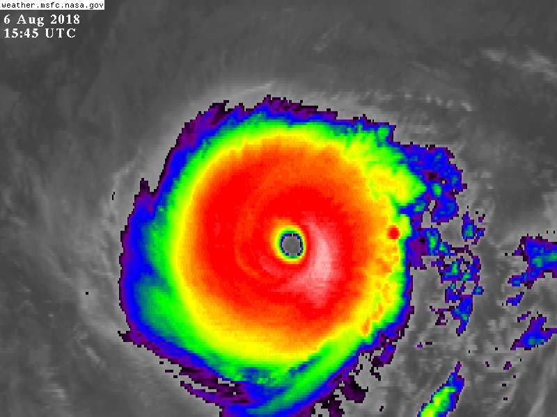
The satellite presentation of Hurricane Hector has improved
overnight, with a well defined 10 to 15 nautical mile wide eye
surrounded by a large ring of -70 to -80 Celsius cloud tops. The
latest subjective Dvorak current intensity estimates from SAB and
JTWC came in at 6.5 (127 knots), while PHFO came in at 6.0 (115
knots). The latest estimate using the Advanced Dvorak technique from
UW-CIMSS yielded 6.8 (135 knots). Given that Hector's satellite
presentation has improved since the previous advisory, we have
elected to raise the initial intensity to 125 knots which correlates
well with a blend of the available intensity estimates. Hector has
continued to track westward at about the same speed as the previous
advisory, so the initial motion remains 280/13 knots.
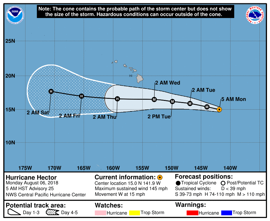
The latest model guidance remains tightly clustered and brings
Hector just north of due west over the next 36 to 48 hours due to a
weakness in the subtropical ridge to the northeast of the Hawaiian
Islands. Beyond 48 hours, the subtropical ridge is forecast to build
to the north of the Hawaiian Island chain, and this should steer
Hector due westward from 48 to 96 hours, before bending back to the
west-northwest beyond 96 hours as a digging upper level trough
between 170W and the International Date Line begins to erode the
western portion of the subtropical ridge. The new official forecast
track is very close to the model consensus and nearly identical to
the previous official track forecast.
Hector will remain in a favorable low shear environment through the
forecast period, but there are some factors that should lead to
gradual weakening over the next few days. The hurricane will be
traveling over marginal sea surface temperatures around 27C through
Wednesday, before the SSTs increase slightly to around 28C to the
south of the Hawaiian Islands Wednesday night through Friday.
Additionally and likely more importantly, very dry mid-level air
will begin to surround the storm beginning later today or tonight,
and this is expected to lead to a slow and gradual weakening of the
system through Wednesday night. The intensity of Hector is then
expected to level off Wednesday night through Friday as it
encounters the higher SSTs, with some indication from the HWRF that
re-intensification could occur. The intensity forecast has been
adjusted slightly higher than the previous forecast due to both the
statistical and dynamical models trending higher and coming into
somewhat better agreement. Given the recent better performance of
the dynamical guidance in comparison to the statistical guidance,
more weight was placed on the dynamical models when preparing the
intensity forecast for this advisory package as well.
A couple reconnaissance missions are scheduled to be flown today
between 18Z and 00Z, one by the Air Force Reserve 53rd Weather
Reconnaissance Squadron which will provide additional important data
to assist in future track and intensity forecasts. The other will be
a NOAA G4 mission which will sample the environment around Hector,
providing valuable data for ingestion into the models.
While the official forecast track continues to lie to the south of
the Hawaiian islands, only a slight deviation to the north of the
forecast track would significantly increase potential impacts to
the state of Hawaii. Now is a good time for everyone in the
Hawaiian Islands to ensure that they have their hurricane plan in
place. For additional information on any potential impacts from
Hector in Hawaii, please refer to products issued by the NWS Weather
Forecast Office here in Honolulu at: http://www.prh.noaa.gov/hnl .
FORECAST POSITIONS AND MAX WINDS
INIT 06/1500Z 15.0N 141.9W 125 KT 145 MPH
12H 07/0000Z 15.4N 144.0W 120 KT 140 MPH
24H 07/1200Z 15.9N 146.9W 115 KT 130 MPH
36H 08/0000Z 16.2N 149.9W 110 KT 125 MPH
48H 08/1200Z 16.5N 153.0W 105 KT 120 MPH
72H 09/1200Z 16.6N 159.3W 95 KT 110 MPH
96H 10/1200Z 17.0N 165.4W 90 KT 105 MPH
120H 11/1200Z 17.7N 170.6W 90 KT 105 MPH
$$
Forecaster Jelsema


|
|