簽到天數: 3291 天 [LV.Master]伴壇終老
|
 t02436|2017-9-4 23:51
|
顯示全部樓層
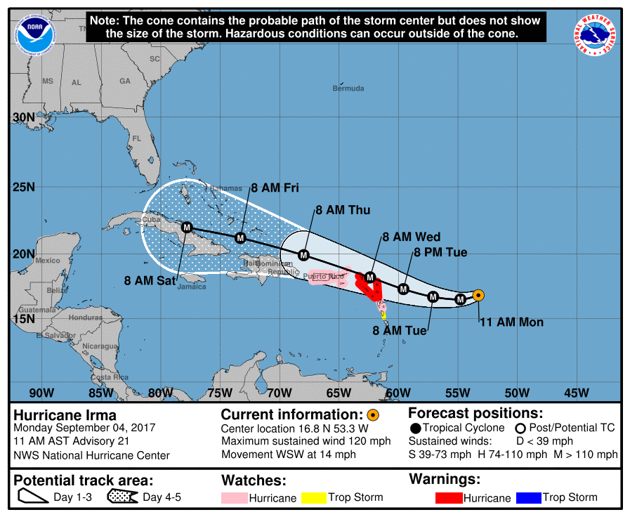
NHC 15Z報巔峰上望125節,預測兩天後抵達背風群島,五天後登陸古巴。
000
WTNT41 KNHC 041449
TCDAT1
Hurricane Irma Discussion Number 21
NWS National Hurricane Center Miami FL AL112017
1100 AM AST Mon Sep 04 2017
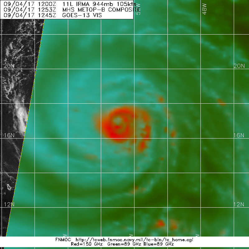
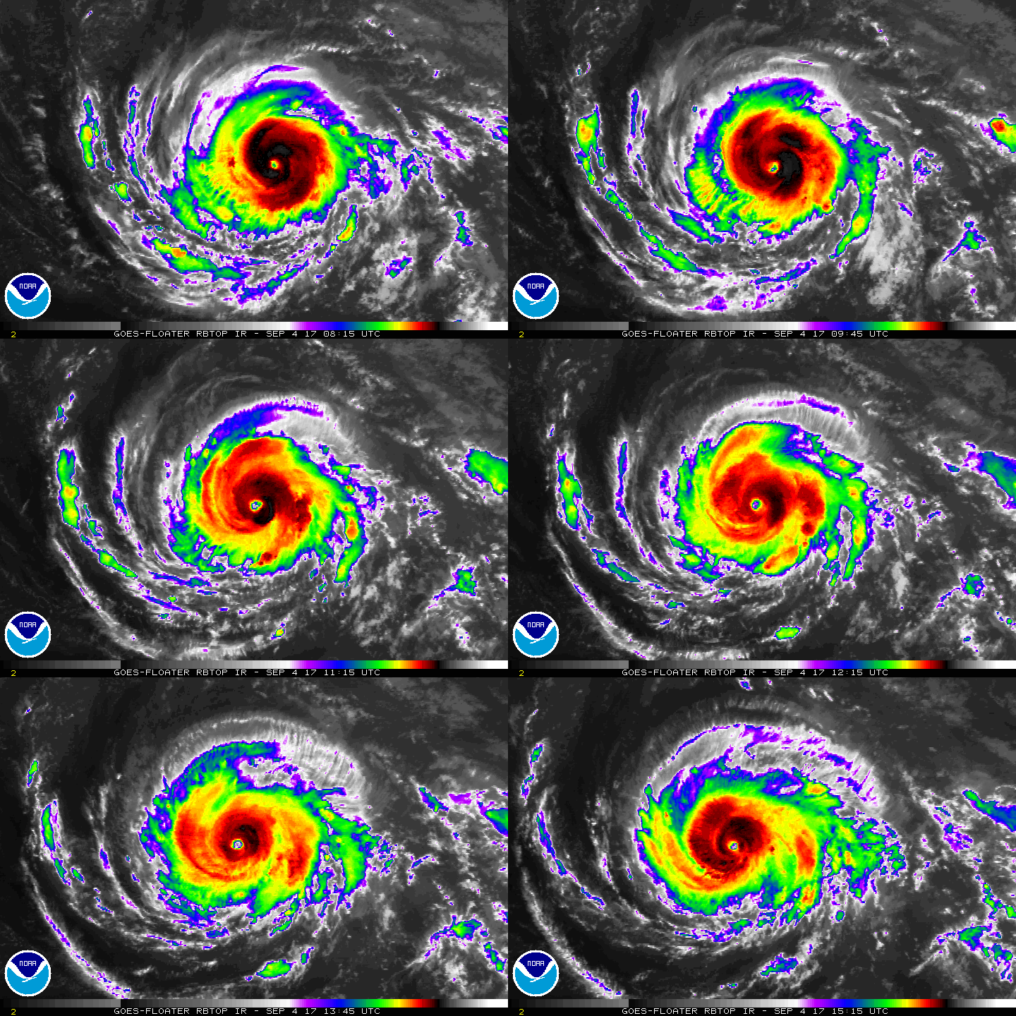
The satellite presentation of Irma has improved markedly over the
past 24 hours, with the eye becoming larger and much more distinct.
A NOAA Hurricane Hunter aircraft has reported peak 700-mb flight
level winds of 117 kt, SFMR winds of 107 kt, and dropsonde data
that support a minimum pressure of around 944 mb. These data
support an initial intensity of 105 kt. The aircraft also reported
concentric eyewalls and a double wind maximum during the last couple
of passes through the center, indicating that an eyewall
replacement cycle has likely begun.
Irma is expected to remain within a very favorable environment for
strengthening during the next several days and additional
intensification appears likely. However, eyewall replacement cycles
are likely to cause some fluctuations in intensity during that time.
The NHC forecast brings the hurricane to category 4 strength within
the next 24 hours, and then maintains Irma as a powerful hurricane
during the next 5 days, assuming that the core of the cyclone does
not move over any of the Greater Antilles.
Irma has been moving west-southwestward or 255/11 kt to the south of
a strong mid-level ridge over the central Atlantic. The hurricane
should turn westward later today or tonight, then west-northwestward
Tuesday as it reaches the southwestern portion of the ridge. As
mentioned in the previous NHC discussion, a large mid-latitude
trough is expected to amplify over the eastern United States during
the next few days. The global models are unanimous in lifting the
trough out to the northeast by late in the week, allowing the
Atlantic ridge to build westward on days 3 through 5. The track
guidance has again shifted westward and southwestward at days 4 and
5, but the models remain in very good agreement through the forecast
period. The updated NHC track forecast has been adjusted
southwestward late in the period, and lies very near the consensus
of the ECMWF, GFS, and HWRF models.
Six hourly upper-air soundings will begin at 1800 UTC today over the
central United States to better sample the upstream mid-latitude
trough. In addition, the NOAA G-IV aircraft will begin sampling the
environment around Irma this afternoon and evening, and these data
will be included in tonight's 0000 UTC model runs.
Users are reminded to not focus on the exact forecast track since
strong winds and heavy rainfall extend well away from the center.
In addition, average NHC track errors are about 175 and 225 statute
miles at days 4 and 5, respectively.
KEY MESSAGES:
1. Irma is expected to affect the northeastern Leeward Islands as a
dangerous major hurricane, accompanied by life-threatening wind,
storm surge, and rainfall impacts, along with rough surf and rip
currents. Hurricane warnings have been issued for portions of the
Leeward Islands. Preparations should be rushed to completion, as
tropical-storm force winds are expected to first arrive in the
hurricane warning area by late Tuesday.
2. Irma could directly affect the British and U.S. Virgin Islands
and Puerto Rico as a dangerous major hurricane later this week.
Hurricane watches have been issued for these areas, and tropical-
storm-force winds could arrive in these areas by early Wednesday.
3. Irma could directly affect Hispaniola, the Turks and Caicos, the
Bahamas, and Cuba as a dangerous major hurricane later this week.
Residents in these areas should monitor the progress of Irma and
listen to advice given by officials.
4. There is an increasing chance of seeing some impacts from Irma in
the Florida Peninsula and the Florida Keys later this week and this
weekend. In addition, rough surf and dangerous marine conditions
will begin to affect the southeastern U.S. coast by later this week.
Otherwise, it is still too early to determine what direct impacts
Irma might have on the continental United States. However, everyone
in hurricane-prone areas should ensure that they have their
hurricane plan in place, as we are now near the peak of the season.
FORECAST POSITIONS AND MAX WINDS
INIT 04/1500Z 16.8N 53.3W 105 KT 120 MPH
12H 05/0000Z 16.5N 54.8W 115 KT 130 MPH
24H 05/1200Z 16.7N 57.1W 120 KT 140 MPH
36H 06/0000Z 17.3N 59.6W 120 KT 140 MPH
48H 06/1200Z 18.2N 62.4W 125 KT 145 MPH
72H 07/1200Z 19.9N 68.0W 120 KT 140 MPH
96H 08/1200Z 21.2N 73.3W 115 KT 130 MPH
120H 09/1200Z 22.0N 77.8W 115 KT 130 MPH...NEAR THE COAST OF CUBA
$$
Forecaster Brown


|
|