簽到天數: 3291 天 [LV.Master]伴壇終老
|
 t02436|2017-8-30 23:37
|
顯示全部樓層
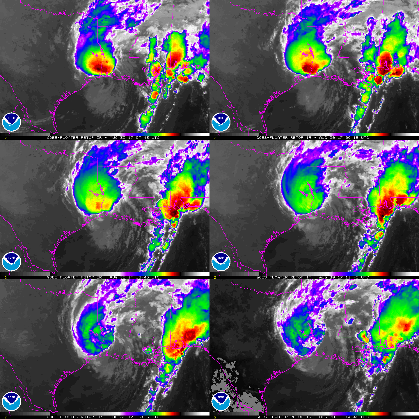
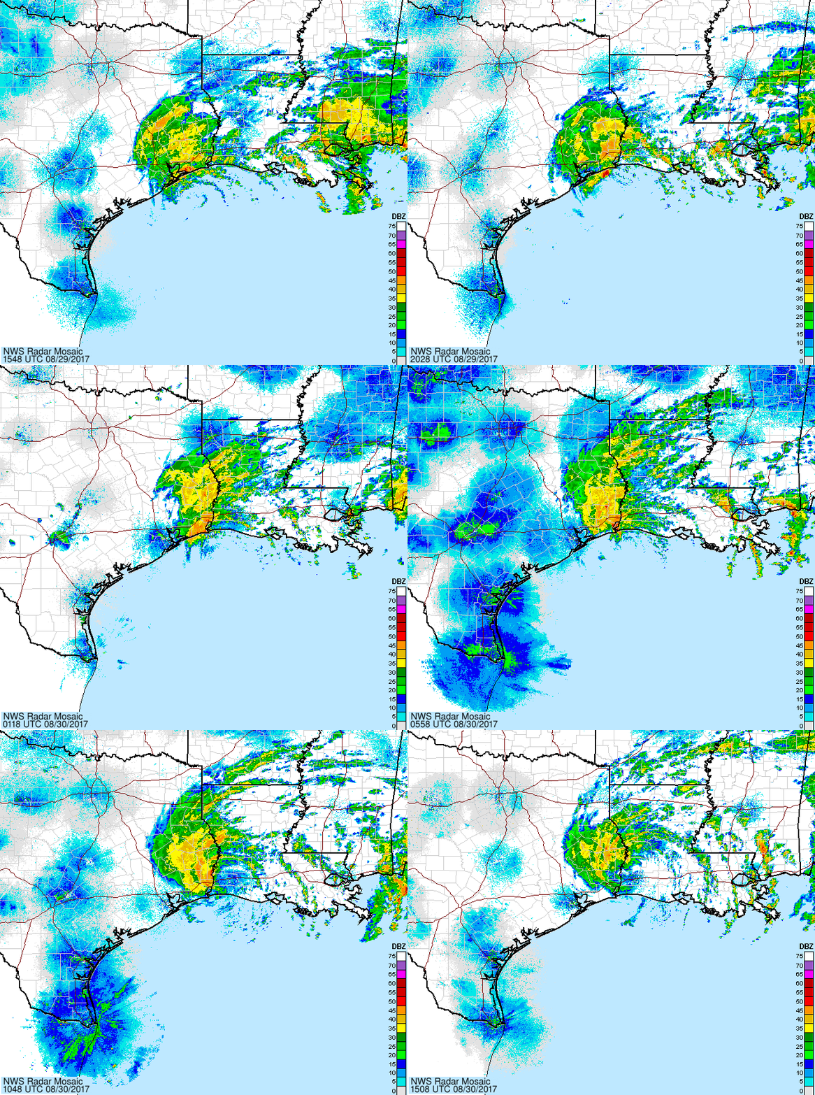
補充,09Z登陸路易斯安那州,德州夢靨即將結束。
ZCZC MIATCPAT4 ALL
TTAA00 KNHC DDHHMM
BULLETIN
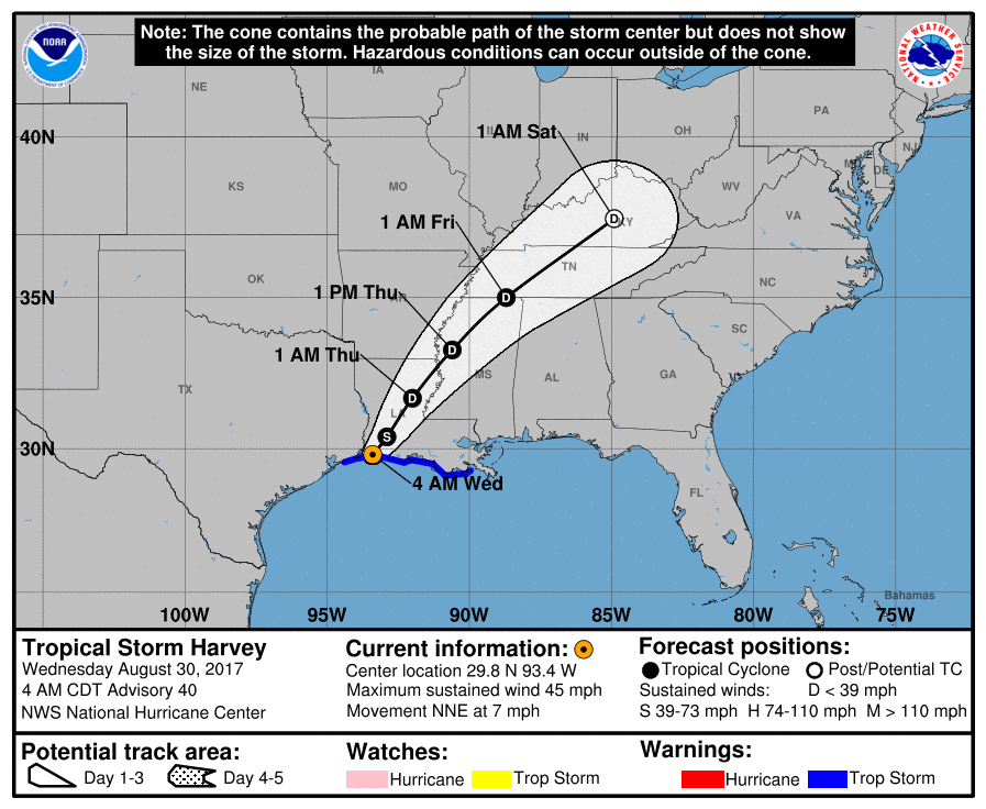
Tropical Storm Harvey Advisory Number 40
NWS National Hurricane Center Miami FL AL092017
400 AM CDT Wed Aug 30 2017
...HARVEY MAKES LANDFALL JUST WEST OF CAMERON LOUISIANA...
...FLOODING RAINS DOUSING EXTREME SOUTHEASTERN TEXAS AND
SOUTHWESTERN LOUISIANA...
SUMMARY OF 400 AM CDT...0900 UTC...INFORMATION
----------------------------------------------
LOCATION...29.8N 93.4W
ABOUT 5 MI...10 KM W OF CAMERON LOUISIANA
ABOUT 30 MI...50 KM ESE OF PORT ARTHUR TEXAS
MAXIMUM SUSTAINED WINDS...45 MPH...75 KM/H
PRESENT MOVEMENT...NNE OR 30 DEGREES AT 7 MPH...11 KM/H
MINIMUM CENTRAL PRESSURE...990 MB...29.24 INCHES
WATCHES AND WARNINGS
--------------------
CHANGES WITH THIS ADVISORY:
The Tropical Storm Warning and Storm Surge Watch have been
discontinued from High Island, Texas, westward.
SUMMARY OF WATCHES AND WARNINGS IN EFFECT:
A Storm Surge Warning is in effect for...
* Holly Beach Louisiana to Morgan City Louisiana
A Storm Surge Watch is in effect for...
* East of High Island Texas to west of Holly Beach Louisiana
A Tropical Storm Warning is in effect for...
* East of High Island Texas to Grand Isle Louisiana
Catastrophic and life-threatening flooding continues in southeastern
Texas and portions of southwestern Louisiana. Please see warnings
and other products issued by your local National Weather Service
office for additional information on this life-threatening
situation.
A Storm Surge Warning means there is a danger of life-threatening
inundation, from rising water moving inland from the coastline,
during the next 12 hours in the indicated locations. For a
depiction of areas at risk, please see the National Weather
Service Storm Surge Watch/Warning Graphic, available at
hurricanes.gov. This is a life-threatening situation. Persons
located within these areas should take all necessary actions to
protect life and property from rising water and the potential for
other dangerous conditions. Promptly follow evacuation and other
instructions from local officials.
For storm information specific to your area, including possible
inland watches and warnings, please monitor products issued by your
local National Weather Service forecast office.
DISCUSSION AND 48-HOUR OUTLOOK
------------------------------
At 400 AM CDT (0900 UTC), the center of Tropical Storm Harvey was
located just inland near latitude 29.8 North, longitude 93.4 West.
Harvey is moving toward the north-northeast near 7 mph (11 km/h). A
north-northeastward and then northeastward motion at a faster
forward speed is expected through Thursday night. On the forecast
track, the center of Harvey will move across the Lower Mississippi
Valley and Tennessee Valley through Thursday.
Maximum sustained winds are near 45 mph (75 km/h) with higher gusts.
Gradual weakening is forecast now that the center has crossed the
coast, and Harvey is expected to become a tropical depression by
tonight.
Tropical-storm-force winds extend outward up to 80 miles (130 km)
from the center.
Surface observations indicate that the estimated minimum central
pressure is 990 mb (29.24 inches).
HAZARDS AFFECTING LAND
----------------------
RAINFALL: Harvey is expected to produce additional rainfall
accumulations of 3 to 6 inches from southwestern Louisiana and the
adjacent border of eastern Texas northeastward into western Kentucky
through Friday with isolated amounts up to 10 inches. While the
threat of heavy rains has ended in the Houston/Galveston area,
catastrophic and life-threatening flooding will continue in and
around Houston eastward into southwest Louisiana for the rest of the
week. The expected heavy rains spreading northeastward from
Louisiana into western Kentucky may also lead to flash flooding and
increased river and small stream flooding. DO NOT ATTEMPT TO TRAVEL
IN THE AFFECTED AREA IF YOU ARE IN A SAFE PLACE. DO NOT DRIVE INTO
FLOODED ROADWAYS. Please see warnings and products issued by your
local National Weather Service office for additional information on
this life-threatening situation.
Elsewhere, the outer bands of Harvey are expected to produce
additional rainfall amounts of 3 to 6 inches over portions of the
central and eastern Gulf States and 2 to 4 inches farther north into
parts of the Tennessee Valley through Friday. These rains may lead
to flooding concerns across these areas.
A list of rainfall observations compiled by the NOAA Weather
Prediction Center can be found at:
www.wpc.ncep.noaa.gov/discussions/nfdscc1.html
STORM SURGE: The combination of a dangerous storm surge and the
tide will cause normally dry areas near the coast to be flooded by
rising waters moving inland from the shoreline. The water is
expected to reach the following heights above ground if the peak
surge occurs at the time of high tide...
Holly Beach to Morgan City...2 to 4 ft
San Luis Pass to west of Holly Beach incl. Galveston Bay...1 to 3 ft
Morgan City to Grand Isle...1 to 2 ft
The deepest water will occur along the immediate coast near the
area of onshore winds. Surge-related flooding depends on the
relative timing of the surge and the tidal cycle, and can vary
greatly over short distances. For information specific to your
area, please see products issued by your local National Weather
Service forecast office.
WIND: Tropical storm conditions are occurring over portions of
the warning area along the coast and are likely to persist through
today.
SURF: Swells generated by Harvey are still affecting the coasts of
Texas and Louisiana. These swells are likely to cause
life-threatening surf and rip current conditions. Please consult
products from your local weather office.
TORNADOES: A few tornadoes are possible today and tonight over
parts of Louisiana, Mississippi, southern Alabama, and southeast
Arkansas.
NEXT ADVISORY
-------------
Next intermediate advisory at 700 AM CDT.
Next complete advisory at 1000 AM CDT.
$$
Forecaster Berg
NNNN
FORECAST POSITIONS AND MAX WINDS
INIT 30/0900Z 29.8N 93.4W 40 KT 45 MPH...INLAND
12H 30/1800Z 30.4N 92.9W 35 KT 40 MPH...INLAND
24H 31/0600Z 31.7N 92.0W 30 KT 35 MPH...INLAND
36H 31/1800Z 33.3N 90.6W 25 KT 30 MPH...INLAND
48H 01/0600Z 35.0N 88.7W 25 KT 30 MPH...INLAND
72H 02/0600Z 37.5N 84.9W 20 KT 25 MPH...POST-TROP/REMNT LOW
96H 03/0600Z...DISSIPATED


|
|