簽到天數: 868 天 [LV.10]以壇為家III
|
 jrchang5|2020-1-8 05:55
|
顯示全部樓層
本帖最後由 jrchang5 於 2020-1-8 16:42 編輯
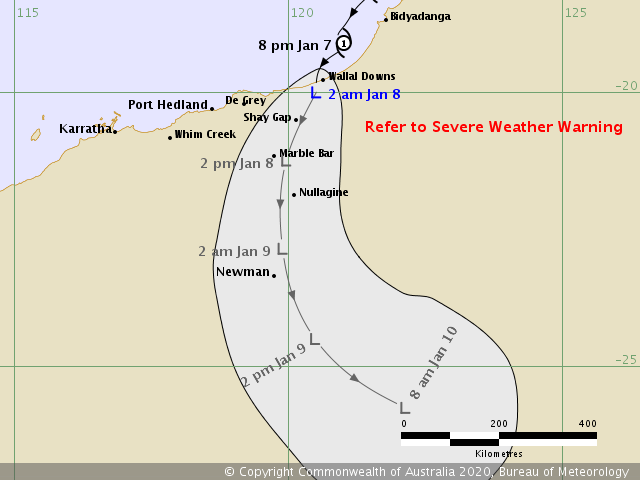
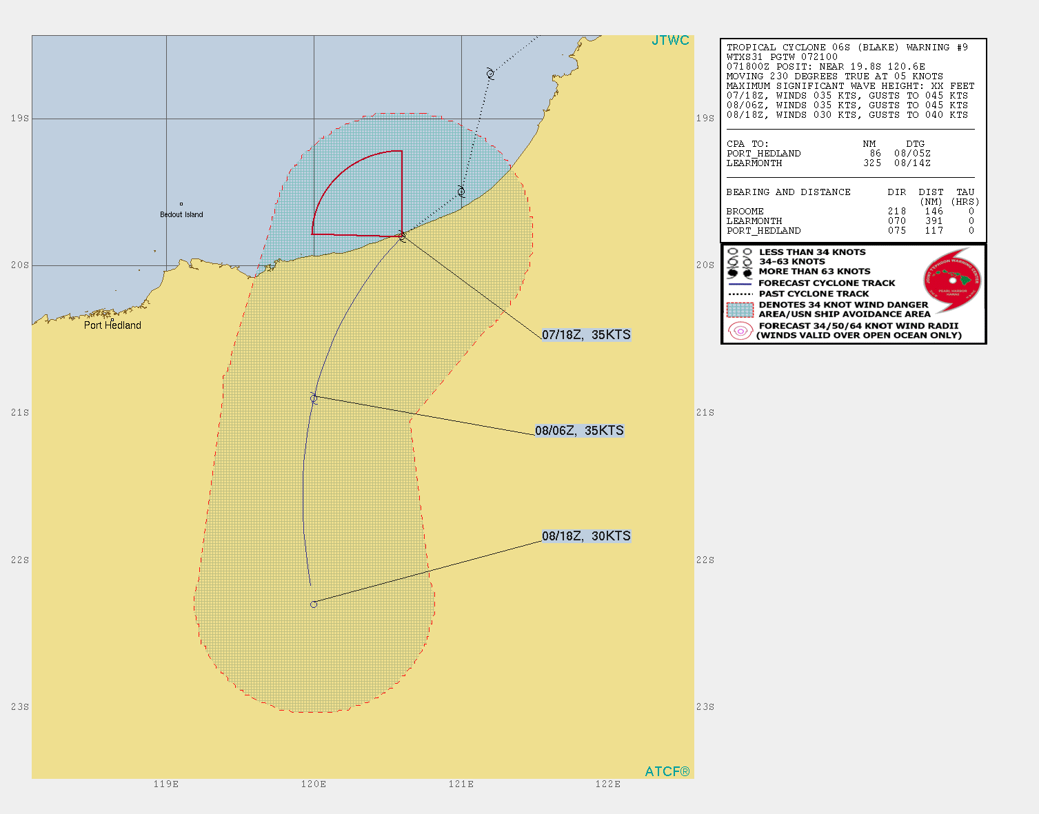
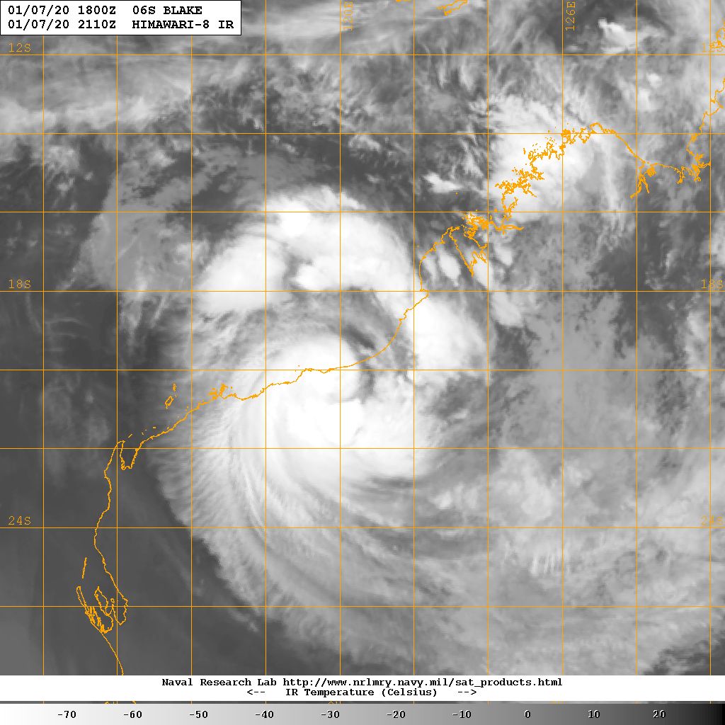
BoM與JTWC均判定07/18Z已登陸西澳北岸。
IDW27600
TROPICAL CYCLONE TECHNICAL BULLETIN: AUSTRALIA - WESTERN REGION
Issued by PERTH TROPICAL CYCLONE WARNING CENTRE
at: 1909 UTC 07/01/2020
Name: Ex-Tropical Cyclone Blake
Identifier: 02U
Data At: 1800 UTC
Latitude: 20.0S
Longitude: 120.5E
Location Accuracy: within 25 nm [45 km]
Movement Towards: southwest [218 deg]
Speed of Movement: 8 knots [14 km/h]
Maximum 10-Minute Wind: 30 knots [55 km/h]
Maximum 3-Second Wind Gust: 45 knots [85 km/h]
Central Pressure: 993 hPa
Radius of 34-knot winds NE quadrant:
Radius of 34-knot winds SE quadrant:
Radius of 34-knot winds SW quadrant:
Radius of 34-knot winds NW quadrant:
Radius of 48-knot winds NE quadrant:
Radius of 48-knot winds SE quadrant:
Radius of 48-knot winds SW quadrant:
Radius of 48-knot winds NW quadrant:
Radius of 64-knot winds:
Radius of Maximum Winds:
Dvorak Intensity Code:
Pressure of outermost isobar: 998 hPa
Radius of outermost closed isobar: 140 nm [260 km]
FORECAST DATA
Date/Time : Location : Loc. Accuracy: Max Wind : Central Pressure
[UTC] : degrees : nm [km]: knots[km/h]: hPa
+06: 08/0000: 20.5S 120.2E: 035 [070]: 030 [055]: 991
+12: 08/0600: 21.2S 120.0E: 050 [090]: 030 [055]: 994
+18: 08/1200: 22.0S 119.8E: 060 [115]: 030 [055]: 995
+24: 08/1800: 22.9S 119.9E: 075 [135]: 030 [055]: 996
+36: 09/0600: 24.5S 120.5E: 095 [175]: 030 [055]: 998
+48: 09/1800: 25.5S 121.6E: 115 [210]: 030 [055]: 999
+60: 10/0600: : : :
+72: 10/1800: : : :
+96: 11/1800: : : :
+120: 12/1800: : : :
REMARKS:
Ex-Tropical Cyclone Blake was located using a combination of surface
observations and radar. The system is currently located over land just to the
south of the east Pilbara coastline.
The system has now moved over land and as such a subjective Dvorak analysis will
cease. FT set at 2.5 and CI 2.5, with the system now weakened below cyclone
intensity. Significant convection is still occurring on the southwestern flank
of the system and heavy rainfall is anticipated to continue throughout Wednesday
and into Thursday as it moves inland.
NWP is in good agreement with Blake forecast to track towards the south
southwest, though there is potential for a more west southwest track in the very
short term.
Model guidance is in general agreement that a low-level circulation maintains
reasonable structure as it moves through inland parts, and even potentially
deepens slightly on Thursday and Friday due to interaction with an upper trough.
As a result, damaging wind gusts around the system will still be possible,
though persistent gales are unlikely.
Copyright Commonwealth of Australia
==
There will be no further bulletins for this system.

WTXS31 PGTW 072100
MSGID/GENADMIN/JOINT TYPHOON WRNCEN PEARL HARBOR HI//
SUBJ/TROPICAL CYCLONE 06S (BLAKE) WARNING NR 009//
RMKS/
1. TROPICAL CYCLONE 06S (BLAKE) WARNING NR 009
01 ACTIVE TROPICAL CYCLONE IN SOUTHIO
MAX SUSTAINED WINDS BASED ON ONE-MINUTE AVERAGE
WIND RADII VALID OVER OPEN WATER ONLY
---
WARNING POSITION:
071800Z --- NEAR 19.8S 120.6E
MOVEMENT PAST SIX HOURS - 230 DEGREES AT 05 KTS
POSITION ACCURATE TO WITHIN 030 NM
POSITION BASED ON CENTER LOCATED BY SATELLITE
PRESENT WIND DISTRIBUTION:
MAX SUSTAINED WINDS - 035 KT, GUSTS 045 KT
WIND RADII VALID OVER OPEN WATER ONLY
DISSIPATING AS A SIGNIFICANT TROPICAL CYCLONE OVER LAND
RADIUS OF 034 KT WINDS - 000 NM NORTHEAST QUADRANT
000 NM SOUTHEAST QUADRANT
000 NM SOUTHWEST QUADRANT
035 NM NORTHWEST QUADRANT
REPEAT POSIT: 19.8S 120.6E
---
FORECASTS:
12 HRS, VALID AT:
080600Z --- 20.9S 120.0E
MAX SUSTAINED WINDS - 035 KT, GUSTS 045 KT
WIND RADII VALID OVER OPEN WATER ONLY
DISSIPATING AS A SIGNIFICANT TROPICAL CYCLONE OVER LAND
VECTOR TO 24 HR POSIT: 180 DEG/ 07 KTS
---
24 HRS, VALID AT:
081800Z --- 22.3S 120.0E
MAX SUSTAINED WINDS - 030 KT, GUSTS 040 KT
WIND RADII VALID OVER OPEN WATER ONLY
DISSIPATED AS A SIGNIFICANT TROPICAL CYCLONE OVER LAND
---
REMARKS:
072100Z POSITION NEAR 20.1S 120.5E.
07JAN20. TROPICAL CYCLONE 06S (BLAKE), LOCATED APPROXIMATELY 117
NM EAST-NORTHEAST OF PORT HEDLAND, AUSTRA, HAS TRACKED
SOUTHWESTWARD AT 05 KNOTS OVER THE PAST SIX HOURS. ANIMATED ENHANCED
INFRARED SATELLITE IMAGERY SHOWS LOW LEVEL BANDING WRAPPING UNDER A
REGION OF DEEP CONVECTION. THIS DEEP CONVECTION CONTINUES TO OBSCURE
THE LOW LEVEL CIRCULATION CENTER (LLCC) POSITIONED WITHIN ITS
NORTHEASTERN PERIPHERY. THE INITIAL POSITION IS SET BASED ON LOW LEVEL
TURNING OBSERVED ON THE PORT HEDLAND RADAR SYSTEM, LENDING GOOD
CONFIDENCE TO THE POSITION. THE INITIAL INTENSITY OF 35 KNOTS IS
SUPPORTED BY A 071800Z OBSERVATION EAST OF THE CURRENT POSITION IN
MANDORA, AUSTRALIA WITH A PRESSURE OF 991 MB. TC 06S REMAINS IN A
REGION OF LOW (10-15 KTS) VERTICAL WIND SHEAR AND GOOD DIVERGENCE
ALOFT. A SUBTROPICAL RIDGE (STR) TO THE SOUTHEAST IS FUNCTIONING AS
THE PRIMARY STEERING MECHANISM FOR TC 06S. THE SYSTEM IS EXPECTED TO
CONTINUE ALONG A SOUTH-SOUTHWESTWARD TRACK, WEAKENING DUE TO LAND
INTERACTION UNTIL DISSIPATION BY TAU 24. NUMERICAL MODELS ARE IN GOOD
OVERALL AGREEMENT THROUGH THE REMAINDER OF THE FORECAST PERIOD. THE
JTWC TRACK FORECAST LIES ALONG THE MULTI-MODEL CONSENSUS, LENDING HIGH
CONFIDENCE IN THE JTWC TRACK FORECAST. NEXT WARNINGS AT 080300Z,
080900Z AND 081500Z.//
NNNN


|
|