開啟輔助訪問
 找回密碼
 立即加入

11L.Irma 橫颳大西洋 逐漸消亡

簽到天數: 601 天

[LV.9]以壇為家II

2017-8-28 19:46 | 顯示全部樓層
本帖最後由 霧峰追風者 於 2017-12-12 07:42 編輯

  五級颶風  
編號:11 L
名稱:Irma
800px-Irma_2017-09-06_1745Z.jpg
  基本資料  
擾動編號日期:2017 08 28 19
命名日期  :2017 08 30 21
撤編日期  :2017 09 13 02
登陸地點  :安圭拉(英屬)
              
       古巴 卡馬圭省             
       美國 佛羅里達州 卡喬島
          佛羅里達州 馬可島

  巔峰時期資料  
近中心最強風速
國家颶風中心(NHC):160 kts
海平面最低氣壓 :914 毫巴

  過去路徑圖  
[attach 11L-艾瑪-Irma.png

]73848[/attach]
  擾動編號資料  
93L-INVEST-25kts-1004mb-12.1N-19.4W

20170828.1030.msg-1.vis.93L.INVEST.25kts.1004mb.12.1N.19.4W.100pc.jpg

  NHC:30%  
1. A tropical wave and associated low pressure area located just
offshore of the coast of western Africa is producing a large area of
showers and thunderstorms. This system has become better organized
since yesterday, and a tropical depression could form in a few days
over the eastern Atlantic.  The low is forecast to move westward at
15 to 20 mph over the tropical Atlantic during the next several
days.  Regardless of development, heavy rain is possible in
portions of the Cabo Verde Islands through Wednesday.
* Formation chance through 48 hours...low...30 percent.
* Formation chance through 5 days...high...70 percent.

two_atl_2d1.png
擷取.PNG
螢幕擷取畫面 (528).png

以上資料來自:NHC、颱風論壇整理製作

評分

參與人數 1水氣能量 +15 收起 理由
jwpk9899 + 15

查看全部評分

回復

使用道具 舉報

簽到天數: 601 天

[LV.9]以壇為家II

霧峰追風者|2017-8-29 02:49 | 顯示全部樓層
NHC 展望提升至40%,穩定西移。
1. A tropical wave and associated low pressure area located a few
hundred miles southeast of the Cabo Verde Islands is producing
disorganized showers and thunderstorms. Environmental conditions
are conducive for development, and a tropical depression could form
in two or three days over the eastern Atlantic.  The low is forecast
to move westward at 15 to 20 mph over the tropical Atlantic during
the next several days. Regardless of development, heavy rain is
possible in portions of the Cabo Verde Islands through Wednesday.
* Formation chance through 48 hours...medium...40 percent.
* Formation chance through 5 days...high...80 percent.
two_atl_2d1 (7).png 20170828.1714.f16.ir.olsircomp.93L.INVEST.x.jpg 93L_intensity_latest.png 93L_gefs_latest.png


點評

展望very high.上看85kts.965hpa  發表於 2017-8-29 10:26
回復

使用道具 舉報

簽到天數: 601 天

[LV.9]以壇為家II

霧峰追風者|2017-8-30 06:59 | 顯示全部樓層
NHC 展望提升至80%。
1. A low pressure area located just west of the Cabo Verde Islands has
become better defined since yesterday.  Any significant increase in
the associated thunderstorm activity would result in the formation
of a tropical depression within the next day or two.  The low is
forecast to move generally west-northwestward at 15 to 20 mph over
the tropical Atlantic during the next several days.  Heavy rain is
possible over portions of the northwestern Cabo Verde Islands
through tonight.
* Formation chance through 48 hours...high...80 percent.
* Formation chance through 5 days...high...90 percent.
two_atl_2d1 (8).png


回復

使用道具 舉報

簽到天數: 3291 天

[LV.Master]伴壇終老

t02436|2017-8-30 23:27 | 顯示全部樓層
依據風場直接升格11L並命名Irma,預期兩天後就能達到颶風強度。
ZCZC MIATCDAT1 ALL
TTAA00 KNHC DDHHMM

Tropical Storm Irma Discussion Number   1
NWS National Hurricane Center Miami FL       AL112017
1100 AM AST Wed Aug 30 2017

Satellite images indicate that the low pressure area in the far
eastern Atlantic has become much better organized since yesterday,
with many curved bands around the center.  ASCAT data showed peak
winds of about 42 kt, and after considering the small size of the
circulation and some undersampling due to the resolution of the
instrument, the initial wind speed is set to 45 kt.
Global models
indicate that the upper-level winds are likely to be favorable for
strengthening of Irma during the next several days.  However, Irma
will be moving over more marginal water temperatures and into drier
mid-level conditions, which should temper the intensification rate.
The NHC solution is a blend of the intensity consensus and the
statistical-dynamical hurricane models SHIPS and LGEM.  At the end
of the period, the forecast could turn out to be conservative if the
very conducive environment shown in most of the global models
emerges.

The initial motion estimate is 280/11.  A ridge over the eastern
Atlantic is forecast to steer Irma westward over the next few days.
Thereafter, the ridge builds southwestward, which will likely cause
the storm to move, somewhat unusually, toward the west-southwest.
The official forecast puts more weight on the global models than the
regional hurricane models, which appear to have a northward bias on
this cycle.  Thus, the NHC track prediction is on the southwestern
side of the guidance envelope, although not as far in that direction
as the ECMWF or its ensemble mean.

FORECAST POSITIONS AND MAX WINDS

INIT  30/1500Z 16.4N  30.3W   45 KT  50 MPH
12H  31/0000Z 16.7N  31.9W   50 KT  60 MPH
24H  31/1200Z 17.3N  33.8W   55 KT  65 MPH
36H  01/0000Z 17.9N  35.7W   60 KT  70 MPH
48H  01/1200Z 18.2N  37.6W   65 KT  75 MPH
72H  02/1200Z 18.7N  41.9W   70 KT  80 MPH
96H  03/1200Z 17.7N  46.5W   75 KT  85 MPH
120H  04/1200Z 17.0N  51.0W   80 KT  90 MPH

$$
Forecaster Blake

NNNN

145752_5day_cone_with_line_and_wind.png

LATEST.jpg

20170830.1300.msg-3.ircolor.11L.IRMA.40kts.1006mb.16.4N.29.8W.100pc.jpg


回復

使用道具 舉報

簽到天數: 601 天

[LV.9]以壇為家II

霧峰追風者|2017-8-30 23:35 | 顯示全部樓層
本帖最後由 霧峰追風者 於 2017-8-31 02:36 編輯

NHC 12Z直接命名"Irma",首報風力給出45Kts,穩定增強中。
ZCZC MIATCDAT1 ALL
TTAA00 KNHC DDHHMM

Tropical Storm Irma Discussion Number   1
NWS National Hurricane Center Miami FL       AL112017
1100 AM AST Wed Aug 30 2017

Satellite images indicate that the low pressure area in the far
eastern Atlantic has become much better organized since yesterday,
with many curved bands around the center.  ASCAT data showed peak
winds of about 42 kt, and after considering the small size of the
circulation and some undersampling due to the resolution of the
instrument, the initial wind speed is set to 45 kt.  Global models
indicate that the upper-level winds are likely to be favorable for
strengthening of Irma during the next several days.  However, Irma
will be moving over more marginal water temperatures and into drier
mid-level conditions, which should temper the intensification rate.
The NHC solution is a blend of the intensity consensus and the
statistical-dynamical hurricane models SHIPS and LGEM.  At the end
of the period, the forecast could turn out to be conservative if the
very conducive environment shown in most of the global models
emerges.

The initial motion estimate is 280/11.  A ridge over the eastern
Atlantic is forecast to steer Irma westward over the next few days.
Thereafter, the ridge builds southwestward, which will likely cause
the storm to move, somewhat unusually, toward the west-southwest.
The official forecast puts more weight on the global models than the
regional hurricane models, which appear to have a northward bias on
this cycle.  Thus, the NHC track prediction is on the southwestern
side of the guidance envelope, although not as far in that direction
as the ECMWF or its ensemble mean.

FORECAST POSITIONS AND MAX WINDS

INIT  30/1500Z 16.4N  30.3W   45 KT  50 MPH
12H  31/0000Z 16.7N  31.9W   50 KT  60 MPH
24H  31/1200Z 17.3N  33.8W   55 KT  65 MPH
36H  01/0000Z 17.9N  35.7W   60 KT  70 MPH
48H  01/1200Z 18.2N  37.6W   65 KT  75 MPH
72H  02/1200Z 18.7N  41.9W   70 KT  80 MPH
96H  03/1200Z 17.7N  46.5W   75 KT  85 MPH
120H  04/1200Z 17.0N  51.0W   80 KT  90 MPH

$$
Forecaster Blake

NNNN

145752_5day_cone_no_line_and_wind.png avn-animated.gif


回復

使用道具 舉報

簽到天數: 601 天

[LV.9]以壇為家II

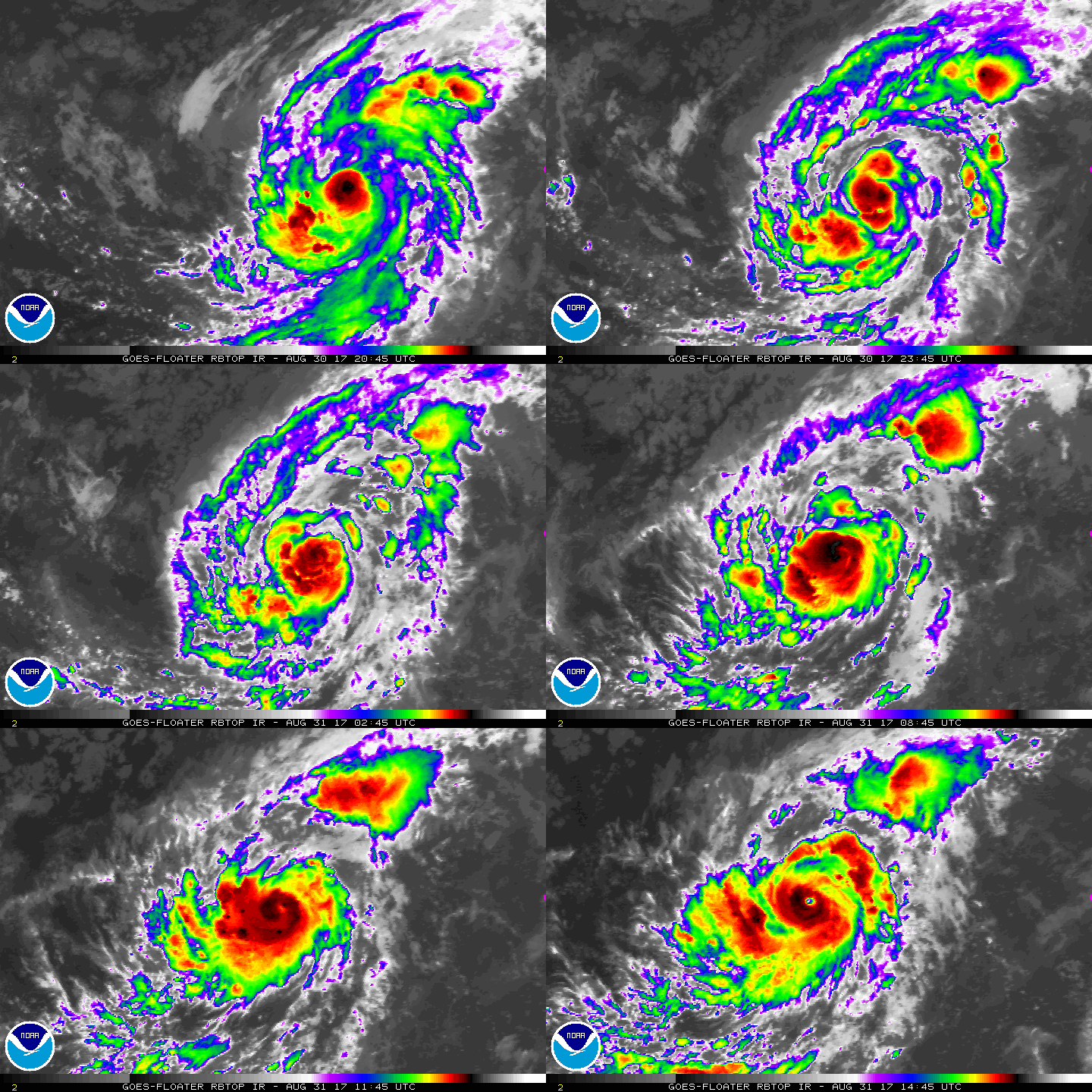
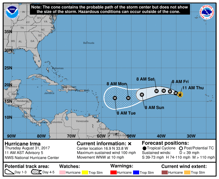
霧峰追風者|2017-8-31 23:53 | 顯示全部樓層
風眼開啟直升Cat.2,數值支持高強度,穩定西移。
000
WTNT41 KNHC 311504 CCA
TCDAT1

Hurricane Irma Discussion Number   5...Corrected
NWS National Hurricane Center Miami FL       AL112017
1100 AM AST Thu Aug 31 2017

Satellite images indicate that Irma is rapidly intensifying.
Very deep convection has formed in the central dense overcast,
which is now displaying a small and clearing eye.  Dvorak estimates
were up to 77 kt at 1200 UTC, and since the cloud pattern continues
to quickly become more organized, the initial wind speed is set to
85 kt.

Irma has moved somewhat south of and slower than all of the model
guidance since yesterday.  Consequently, it stayed longer over the
warmer ocean temperatures away from the drier air to the north,
possibly allowing the rapid strengthening.  Irma should move over
cooler waters tomorrow with some increase in mid-level dry air, so
hopefully the hurricane's intensity will level off by then.  In a
few days, the hurricane will be moving over warmer waters with light
shear shown by all of the model guidance.  This should promote
further strengthening of Irma, and the NHC forecast shows an
extremely dangerous category 4 hurricane next week, similar to the
solutions provided by the HWRF and the ECMWF models. The intensity
forecast is raised considerably from the previous one due to initial
trends, and is on the high end of the guidance at long range.

The hurricane has turned west-northwestward at about 9 kt.  This
motion should continue for the next day or so before a ridge builds
over the central Atlantic Ocean.  This ridge should force Irma to
turn westward by the weekend, and west-southwestward early next
week. Guidance continues to trend southward, following the trend of
the ECMWF model starting yesterday.  Given the strength of the ridge
and depth of the tropical cyclone, there are no obvious reasons to
discount the anomalous west-southwestward motion seen in most of the
guidance. Little change is made to the track forecast in short
range, but the track is shifted southward and westward at long
range, though not as far southwest as the overnight ECMWF and ECMWF
ensemble models.


FORECAST POSITIONS AND MAX WINDS

INIT  31/1500Z 16.9N  33.8W   85 KT 100 MPH
12H  01/0000Z 17.5N  35.2W  100 KT 115 MPH
24H  01/1200Z 18.0N  37.1W  105 KT 120 MPH
36H  02/0000Z 18.2N  39.2W  105 KT 120 MPH
48H  02/1200Z 18.1N  41.6W  105 KT 120 MPH
72H  03/1200Z 17.0N  46.5W  110 KT 125 MPH
96H  04/1200Z 16.0N  51.0W  110 KT 125 MPH
120H  05/1200Z 16.0N  55.5W  115 KT 130 MPH

$$
Forecaster Blake
145426_5day_cone_no_line_and_wind.png rbtop-animated.gif

回復

使用道具 舉報

簽到天數: 582 天

[LV.9]以壇為家II

蜜露|2017-9-1 01:35 | 顯示全部樓層
本帖最後由 蜜露 於 2017-9-1 01:36 編輯


增強速度很快 , 前方環境又好 .

GFS很久沒有在大西洋有這樣的誇張預報了 .(或許是首次)

gfs_mslp_wind_atl_35.png


未來的200h+ 會有很強的一個颶風在大西洋 ..

我記得上次這麼長的巔峰好像是2015年南卡

有可能是 (Irma 伊瑪) 的再世喵 ~ !

2017AL11_OHCNFCST_201708311200.GIF


回復

使用道具 舉報

簽到天數: 1989 天

[LV.Master]伴壇終老

ben811018|2017-9-2 10:39 | 顯示全部樓層
AL112017_5day_cone_no_line.png 11L_gefs_latest.png LATEST.jpg 20170901.2122.f17.91pct91h91v.11L.IRMA.100kts.967mb.18.8N.38.5W.055pc.jpg ecmwf_mslp_uv850_us_11.png hwrf_satIR_11L_22.png 11L_intensity_latest.png

穩定增強中
後期路徑變數大

點評

北大西洋這位置要155kts不容易. 過去未見過  發表於 2017-9-2 21:50
上看140kts.918hpa,不排除會有155kts以上強度  發表於 2017-9-2 14:42
回復

使用道具 舉報

快速回覆
您需要登錄後才可以回帖 登錄 | 立即加入

本版積分規則

霧峰追風者

    主題

    帖子

    221萬

    積分

    16級[四級颶風]

    Rank: 16Rank: 16Rank: 16Rank: 16

16級[四級颶風]

發訊息

本平台僅供學術討論之用,預報應以氣象局為準

威普網站虛擬主機贊助公司

臺灣第一個天氣類型社群平台 即時天氣資訊、精準颱風動態

線上客服
FB傳送訊息
廣告行銷
精準行銷 物超所值
官方粉專
發佈 快速回復 返回頂部 返回列表