開啟輔助訪問
 找回密碼
 立即加入

01L.Ana 中心登陸 逐漸減弱

簽到天數: 3280 天

[LV.Master]伴壇終老

t02436|2015-5-8 01:07 | 顯示全部樓層
本帖最後由 t02436 於 2015-5-8 01:12 編輯

風場掃描顯示周圍風力部分達到35節


美國海軍二度發布TCFA


NWS發布烈風警報
...GALE WARNING...
.LOW 31N78W 1008 MB MOVING N 10 KT. OVER FORECAST WATERS FROM
31N TO 35N BETWEEN 70W AND 81W WINDS TO 25 TO 35 KT. SEAS TO 11
FT.
.24 HOUR FORECAST LOW 32N78W 1006 MB. N OF 31N WITHIN 180 NM OF
CENTER WINDS 25 TO 35 KT. SEAS 9 TO 13 FT.
.48 HOUR FORECAST LOW 33N77W 1010 MB. WITHIN 180 NM E AND NE
QUADRANTS WINDS 25 TO 35 KT. SEAS TO 12 FT.


飛機實測現正進行中


掃出最大風力55節

以下為自動更新數據
實測結束後停止更新。
AF304 Mission #01 into INVEST


本帖子中包含更多資源

您需要 登錄 才可以下載或查看,沒有賬號?立即加入

x

評分

參與人數 1水氣能量 +50 收起 理由
ben811018 + 50

查看全部評分

回復

使用道具 舉報

簽到天數: 1989 天

[LV.Master]伴壇終老

ben811018|2015-5-7 18:01 | 顯示全部樓層
不同角度~存圖一下!


本帖子中包含更多資源

您需要 登錄 才可以下載或查看,沒有賬號?立即加入

x
回復

使用道具 舉報

簽到天數: 242 天

[LV.8]以壇為家I

shadow16|2015-5-7 14:21 | 顯示全部樓層


ZCZC MIATWOAT ALL
TTAA00 KNHC DDHHMM

SPECIAL TROPICAL WEATHER OUTLOOK
NWS NATIONAL HURRICANE CENTER MIAMI FL
150 AM EDT THU MAY 7 2015

For the North Atlantic...Caribbean Sea and the Gulf of Mexico:

1. A non-tropical low pressure system located about 220 miles
south-southeast of the South Carolina-North Carolina border has been
nearly stationary the past several hours. Showers and thunderstorms
are gradually becoming better organized and environmental conditions
are expected to become more conducive for development over the next
day or so while this system moves slowly northward and then
northwestward.  A subtropical or tropical cyclone could form later
today or on Friday, and interests along the southeast coast of the
United States should monitor the progress of this system.  An Air
Force Reserve reconnaissance aircraft is scheduled to investigate
the low later this morning. Regardless of development, heavy rain is
possible over portions of the coastal southeastern United States
beginning later today.  The next Special Tropical Weather Outlook
will be issued on this system by 8 AM EDT this morning.  For
additional information, see products from your local National
Weather Service forecast office and High Seas Forecasts issued by
the National Weather Service.
* Formation chance through 48 hours...high...70 percent
* Formation chance through 5 days...high...70 percent

本帖子中包含更多資源

您需要 登錄 才可以下載或查看,沒有賬號?立即加入

x
回復

使用道具 舉報

簽到天數: 242 天

[LV.8]以壇為家I

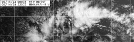
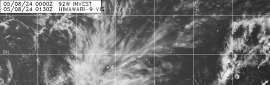
shadow16|2015-5-6 20:20 | 顯示全部樓層


ZCZC MIATWOAT ALL
TTAA00 KNHC DDHHMM

SPECIAL TROPICAL WEATHER OUTLOOK
NWS NATIONAL HURRICANE CENTER MIAMI FL
800 AM EDT WED MAY 6 2015

For the North Atlantic...Caribbean Sea and the Gulf of Mexico:

1. Disorganized showers and thunderstorms extending over portions of
Florida, the Bahamas, and adjacent waters are associated with an
upper-level trough and a weak surface low located over the
northwestern Bahamas.  The aircraft reconnaissance mission scheduled
for this afternoon has been cancelled.  However, conditions are
expected to become gradually more favorable for development over the
next day or so while the system moves slowly northward.  A
subtropical or tropical cyclone could form by Thursday or Friday,
and interests along the southeast coast of the United States should
monitor the progress of this system through the weekend. The next
Special Tropical Weather Outlook will be issued on this system by 8
PM EDT today. For additional information, see High Seas Forecasts
issued by the National Weather Service.
* Formation chance through 48 hours...medium...60 percent
* Formation chance through 5 days...medium...60 percent

本帖子中包含更多資源

您需要 登錄 才可以下載或查看,沒有賬號?立即加入

x
回復

使用道具 舉報

簽到天數: 588 天

[LV.9]以壇為家II

Meow|2015-5-6 16:17 | 顯示全部樓層
NHC認為有成為副熱帶氣旋的機會,一旦增強到副熱帶風暴就會命名Ana,不過這算季外系統。
回復

使用道具 舉報

12
快速回覆
您需要登錄後才可以回帖 登錄 | 立即加入

本版積分規則

本平台僅供學術討論之用,預報應以氣象局為準

威普網站虛擬主機贊助公司

臺灣第一個天氣類型社群平台 即時天氣資訊、精準颱風動態

線上客服
FB傳送訊息
廣告行銷
精準行銷 物超所值
官方粉專
發佈 快速回復 返回頂部 返回列表