簽到天數: 3280 天 [LV.Master]伴壇終老
|
 t02436|2015-2-19 09:51
|
顯示全部樓層
t02436|2015-2-19 09:51
|
顯示全部樓層
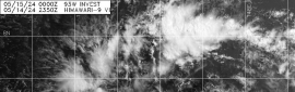
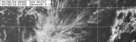
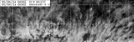
底層掃描顯示貌似在建立眼牆!?
可見光也可略為看見風眼
風切有減弱趨勢
BoM升格二級熱帶氣旋
預計明天開始將對東部陸地造成影響
亦認為會在12小時內達到巔峰
IDQ20018
TROPICAL CYCLONE TECHNICAL BULLETIN: AUSTRALIA - EASTERN REGION
Issued by BRISBANE TROPICAL CYCLONE WARNING CENTRE
at: 0104 UTC 19/02/2015
Name: Tropical Cyclone Marcia
Identifier: 14U
Data At: 0000 UTC
Latitude: 19.9S
Longitude: 152.1E
Location Accuracy: within 15 nm [30 km]
Movement Towards: southwest [230 deg]
Speed of Movement: 12 knots [23 km/h]
Maximum 10-Minute Wind: 50 knots [95 km/h]
Maximum 3-Second Wind Gust: 70 knots [130 km/h]
Central Pressure: 991 hPa
Radius of 34-knot winds NE quadrant: 40 nm [75 km]
Radius of 34-knot winds SE quadrant: 80 nm [150 km]
Radius of 34-knot winds SW quadrant: 80 nm [150 km]
Radius of 34-knot winds NW quadrant: 40 nm [75 km]
Radius of 48-knot winds NE quadrant: 20 nm [35 km]
Radius of 48-knot winds SE quadrant: 20 nm [35 km]
Radius of 48-knot winds SW quadrant: 20 nm [35 km]
Radius of 48-knot winds NW quadrant: 20 nm [35 km]
Radius of 64-knot winds:
Radius of Maximum Winds: 15 nm [30 km]
Dvorak Intensity Code: T3.5/3.5/D1.0/24HRS
Pressure of outermost isobar: 1008 hPa
Radius of outermost closed isobar: 180 nm [335 km]
FORECAST DATA
Date/Time : Location : Loc. Accuracy: Max Wind : Central Pressure
[UTC] : degrees : nm [km]: knots[km/h]: hPa
+06: 19/0600: 20.7S 151.3E: 040 [080]: 050 [095]: 990
+12: 19/1200: 21.4S 150.8E: 055 [100]: 055 [100]: 987
+18: 19/1800: 22.3S 150.4E: 065 [125]: 050 [095]: 986
+24: 20/0000: 23.3S 150.2E: 080 [145]: 045 [085]: 992
+36: 20/1200: 25.2S 150.6E: 100 [185]: 030 [055]: 1002
+48: 21/0000: 27.2S 151.9E: 120 [220]: 030 [055]: 1001
+60: 21/1200: 28.9S 153.4E: 140 [255]: 030 [055]: 1000
+72: 22/0000: 29.6S 154.6E: 155 [290]: 030 [055]: 998
+96: 23/0000: 30.5S 156.1E: 200 [370]: 030 [055]: 998
+120: 24/0000: 33.4S 159.6E: 290 [535]: 030 [055]: 998
REMARKS:
The system has undergone a developing trend during the last 24 hours. CIMSS deep
layer shear shows only 5 to 10 knots of northeasterly shear over the system,
consistent with recent microwave passes showing only marginal displacement of
the centre between the low and mid levels.
The satellite signature has been largely CDO-like during the last 24 hours,
showing evidence of shear reducing with a more uniform distribution of the
temperature gradient around the deep convection compared with 24 hours ago.
Confidence of the LLCC position is high given recent microwave and visible
satellite pictures, and is located more than 1 degree under the deep convection.
DT is therefore 3.5. MET is 3.0, and PAT is 3.5. Final T 3.5.
Intensity is analysed at 50 knots 10 minute mean, based on Dvorak and supported
by 23Z ASCAT pass which shows a small area of 50 knot winds in the southeast
quadrant. Surface automatic weather station obs at Marion Reef reached 42 knots
at 2120Z. A TMI microwave pass at 2106Z depicted a partially complete eye wall
with approximately 0.8 wrap, and this is reflected in the 2332 MTSAT VIS image.
Confidence in the track forecast remains high with a strong steering influence
from the mid-level ridge to the east and upper trough to the west. NWP tracks
are generally tightly clustered around a landfall near Shoalwater Bay on the
central Queensland coast early on Friday morning local time. Expect the along
track shear to remain low to moderate prior to landfall, allowing
intensification at or just below the standard rate until then. NWP models show
some assymetrization of the mid-level signature
The system has curved onto a southwesterly track in the past 12 hours, under the
dominant steering influence of a subtroical ridge to the east. The latter
feature should remain the primary steering influence, and this should see Marcia
continue a general southwesterly track with little change in forward speed up to
landfall on the central Queensland coast early Friday morning. Deterministic and
ensemble NWP models are tightly clustered in agreement with this track scenario.
Models suggest the E/NE vertical shear should remain relatively weak for the
period it spends over water, and with little change in ocean heat content under
the forecast track, this should allow the system to intensify at or just below
the standard rate up to landfall.
Copyright Commonwealth of Australia
==
The next bulletin for this system will be issued by: 19/0700 UTC by Brisbane
TCWC.
|
本帖子中包含更多資源
您需要 登錄 才可以下載或查看,沒有賬號?立即加入
x
|