簽到天數: 2414 天 [LV.Master]伴壇終老
|
 0908morakot|2022-11-8 23:12
|
顯示全部樓層
000
WTNT42 KNHC 070900
TCDAT2
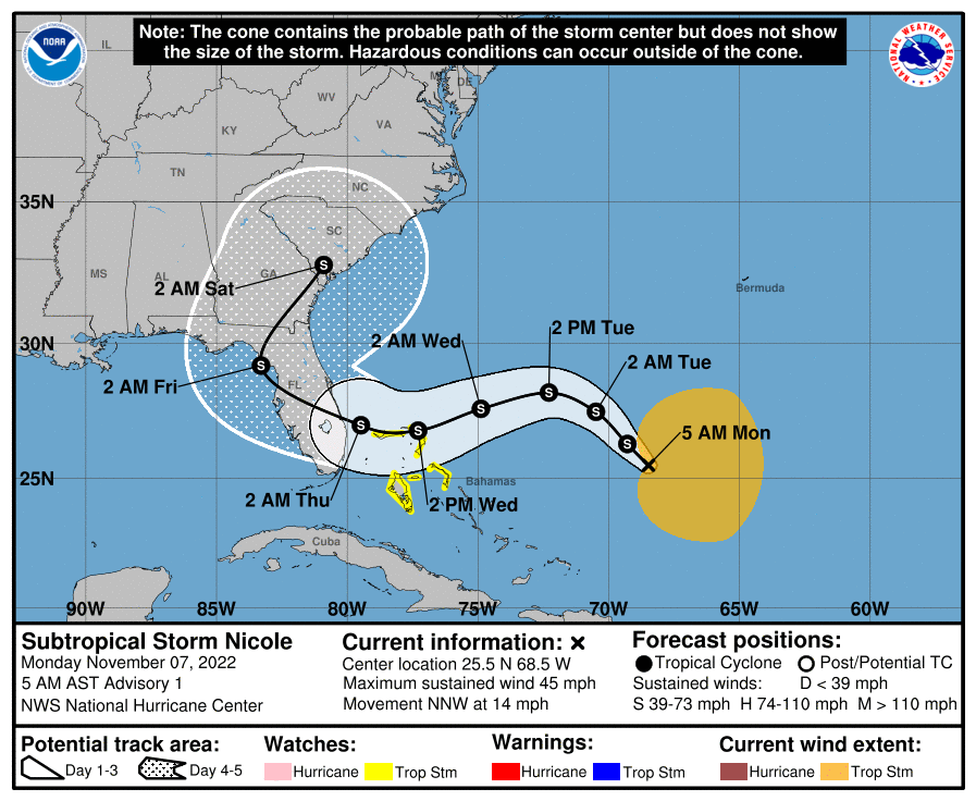
Subtropical Storm Nicole Discussion Number 1
NWS National Hurricane Center Miami FL AL172022
500 AM AST Mon Nov 07 2022
The area of disturbed weather that NHC has been monitoring over the
southwestern Atlantic Ocean has been gradually becoming better
organized. Scatterometer data and buoy observations from last
evening indicated that the system has developed a sufficiently
well-defined center of circulation, with gale-force winds as high as
40 kt occurring in a band that lies between 180-240 n mi to the east
of the center. Moderate to deep convection has also increased a
bit, with TAFB providing a subtropical Hebert-Poteat classification
of ST1.5. Given these data, the system is now being classified as a
subtropical storm.
Since Nicole's center has only recently formed, the initial motion
is a little uncertain, but the best estimate is north-northwestward,
or 330/12 kt. Model guidance indicates that the system should turn
northwestward and slow down later today, followed by a turn toward
the west and west-southwest tonight through Tuesday night due to a
mid-level ridge axis poking eastward off the U.S. Mid-Atlantic
coast. In about 3 days, the high over the southeastern United
States will slide eastward over the Atlantic as a large mid-latitude
trough traverses the country, and Nicole is expected to make a sharp
recurvature toward the north and northeast on days 4 and 5 in the
vicinity of Florida. The track guidance is in fairly good agreement
on this scenario, and the official NHC track forecast is fairly
close to the TVCN and HCCA consensus aids.
Some gradual strengthening is anticipated over the next few days,
although Nicole's sprawling nature does not favor fast
intensification, at least not initially. For the first couple of
days of the forecast, the NHC intensity prediction closely follows
the GFS global model solution. Although Nicole is likely to
maintain a large wind field, models suggest that it could make a
transition to a tropical cyclone and develop a smaller inner-core
wind field in about 2 to 3 days, and at that point more significant
intensification is possible. For now, the NHC intensity forecast
brings Nicole close to hurricane strength in 60-72 hours while it
moves near the northwestern Bahamas and approaches the east coast of
Florida, which is in line with the HCCA consensus aid. It's not out
of the question for Nicole to reach hurricane strength, especially
given how warm the waters are in the vicinity of the Bahamas. It
should be stressed, however, that no matter Nicole's ultimate
intensity, the storm's large size will likely cause significant
wind, storm surge, and rainfall impacts over a large portion of the
northwestern Bahamas, Florida, and the southeastern coast of the
United States during much of the upcoming week.
Key Messages:
1. Nicole is forecast to be a large storm, and regardless of its
exact path, widespread impacts from a prolonged period of coastal
flooding, tropical-storm-force winds, heavy rainfall, rough surf
and rip currents, and beach erosion are likely along much of the
southeastern United States coast, the Florida east coast, and
portions of the northwestern and central Bahamas during much of the
upcoming week.
2. Nicole could be at or near hurricane strength when it moves
near the northwestern Bahamas and the east coast of Florida
Wednesday and Thursday, bringing the potential for a dangerous
storm surge, damaging winds, and heavy rainfall to a portion of
those areas. A Tropical Storm Watch is now in effect for the
northwestern Bahamas, and additional watches could be required for
portions of the Bahamas and the coast of Florida later today.
FORECAST POSITIONS AND MAX WINDS
INIT 07/0900Z 25.5N 68.5W 40 KT 45 MPH
12H 07/1800Z 26.3N 69.3W 40 KT 45 MPH
24H 08/0600Z 27.5N 70.5W 45 KT 50 MPH
36H 08/1800Z 28.2N 72.3W 50 KT 60 MPH
48H 09/0600Z 27.6N 74.9W 55 KT 65 MPH...TROPICAL CYCLONE
60H 09/1800Z 26.8N 77.3W 60 KT 70 MPH
72H 10/0600Z 27.0N 79.5W 60 KT 70 MPH
96H 11/0600Z 29.2N 83.3W 45 KT 50 MPH
120H 12/0600Z 32.8N 80.9W 45 KT 50 MPH...INLAND
$$
Forecaster Berg

|
|