開啟輔助訪問
 找回密碼
 立即加入

16E.Orlene 直撲墨西哥

簽到天數: 2414 天

[LV.Master]伴壇終老

2022-10-2 21:50 | 顯示全部樓層
基本資料  
編號    :16 E
擾動編號日期:2022 09 28 02
撤編日期  :2022 10 00 00
97E.INVEST.25kts.1009mb.13.4N.99.6W

20220927.1740.goes-16.ir.97E.INVEST.25kts.1009mb.13.4N.99.6W.100pc.jpg

  NHC:40%  
1. South of the Southern Coast of Mexico:
An area of low pressure located south of the southern coast of
Mexico continues to produce a broad area of disorganized showers
and thunderstorms. Environmental conditions appear conducive for
additional development, and a tropical depression is likely to form
by the end of this week while the system moves westward to
west-northwestward off the coast of southern and southwestern
Mexico.
* Formation chance through 48 hours...medium...40 percent.
* Formation chance through 5 days...high...80 percent.

two_pac_2d1.png

評分

參與人數 1水氣能量 +15 +1 收起 理由
t02436 + 15 + 1

查看全部評分

回復

使用道具 舉報

簽到天數: 2414 天

[LV.Master]伴壇終老

0908morakot|2022-10-2 21:51 | 顯示全部樓層
9/29 03Z編號16E
000
WTPZ41 KNHC 290240
TCDEP1

Tropical Depression Sixteen-E Discussion Number   1
NWS National Hurricane Center Miami FL       EP162022
1000 PM CDT Wed Sep 28 2022

The area of low pressure located south of the southwestern coast of
Mexico has steadily gained organization throughout the day. Recent
microwave imagery indicated the formation of convective banding and
an earlier partial ASCAT pass suggested the system likely has a
well-defined center. Recent Dvorak classifications from TAFB and SAB
were both 2.0, another sign that the system has become better
organized. Collectively these data support classifying the system as
a tropical cyclone, and advisories have been initiated on Tropical
Depression Sixteen.

For the next 48 to 60 h, the forecast is fairly straightforward with
high confidence. The depression is moving toward the west-northwest
near 9 kt, and that general motion should continue as the system is
steered by a mid-level ridge centered over Mexico. Environmental
conditions appear conducive for strengthening, and all of the
intensity models suggest it will become a tropical storm quickly,
and continue strengthening to hurricane intensity a day or two after
that.

The main concern with the forecast is what happens beyond 60 h, when
confidence in the forecast decreases considerably. There is a clear
bifurcation in the track guidance at that point that appears to be
linked to the intensity and vertical extent of the cyclone. If the
cyclone is relatively deep at that point, which is shown by all of
the normally reliable intensity guidance, it will likely turn
northward or north-northeastward as it interacts with a mid- to
upper-level trough. However, some models like the ECMWF forecast a
shallower cyclone that takes a drastically different path slowly
westward, steered primarily by lower-level winds. The result is a
massive spread in the track guidance, with most of the consensus
aids caught somewhat between those two scenarios. Although the ECMWF
solution can not be dismissed entirely, the more skillful intensity
guidance (supported by the favorable environment) suggest that the
eastern solution toward Mexico may be more likely. The NHC forecast
therefore favors the northeastern solution and shows the cyclone
moving toward the coast of Mexico by 72-96 h. Strong upper-level
winds associated with the aforementioned trough and a drier
surrounding environment should cause the cyclone to weaken as it
moves closer to the coast, and it will likely quickly dissipate if
it moves inland. The NHC intensity forecast is close to the
intensity consensus throughout the forecast, except at 96 h to
reflect that the official forecast position is still over water at
that time.


FORECAST POSITIONS AND MAX WINDS

INIT  29/0300Z 14.4N 103.7W   30 KT  35 MPH
12H  29/1200Z 15.1N 105.3W   35 KT  40 MPH
24H  30/0000Z 16.1N 107.1W   45 KT  50 MPH
36H  30/1200Z 16.8N 108.3W   55 KT  65 MPH
48H  01/0000Z 17.5N 108.5W   65 KT  75 MPH
60H  01/1200Z 18.5N 108.1W   70 KT  80 MPH
72H  02/0000Z 19.7N 107.7W   75 KT  85 MPH
96H  03/0000Z 23.0N 107.0W   60 KT  70 MPH
120H  04/0000Z 25.0N 106.0W   25 KT  30 MPH...POST-TROP/INLAND

$$
Forecaster D. Zelinsky
024158_5day_cone_with_line_and_wind.png
回復

使用道具 舉報

簽到天數: 2414 天

[LV.Master]伴壇終老

0908morakot|2022-10-2 21:52 | 顯示全部樓層
9/29 09Z報命名

000
WTPZ41 KNHC 290832
TCDEP1

Tropical Storm Orlene Discussion Number   2
NWS National Hurricane Center Miami FL       EP162022
400 AM CDT Thu Sep 29 2022

The depression has strengthened into Tropical Storm Orlene. A mass
of deep convection with cloud tops as cold as -80 degrees C has
persisted over the center of the cyclone for the past several hours.
In addition, a pair of recent ASCAT overpasses showed
non-rain-flagged wind vectors of 31 kt and some believable vectors
of 36 kt. Based on this, the initial advisory intensity has been
set at 35 kt.

The cyclone is moving west-northwestward at 11 kt to the south of a
mid-level ridge centered over Mexico. This motion is expected to
continue for the next day or so. After that time, the track
forecast becomes highly uncertain due to diverging track solutions.
The UKMET and ECMWF indicate a cyclone that does not strengthen any
further, and turns it westward in a couple of days in the low-level
flow. The remaining model solutions indicate a stronger cyclone,
and turn Orlene northward over the weekend as the system rounds the
western periphery of the ridge. This scenario would bring the
cyclone near the coast of Mexico or the southern Baja California
peninsula early next week. The NHC track forecast favors the latter
solution due to the favorable environmental conditions ahead of
Orlene, and is in agreement with the TVCE consensus.

Orlene is forecast to be within an environment of low vertical wind
shear and plenty of atmospheric moisture while over warm waters for
the next few days. The majority of guidance, except the
aforementioned ECMWF and UKMET indicate steady strengthening during
this time, and bring Orlene to hurricane intensity by 36 h. After
72 h the cyclone is expected to encounter drier air and strong
southwesterly shear, which should induce a weakening trend.  The
latest NHC intensity forecast is little changed from the previous
one and is close to the multi-model consensus IVCN through 48 h and
is a little below it thereafter.


FORECAST POSITIONS AND MAX WINDS

INIT  29/0900Z 14.8N 104.9W   35 KT  40 MPH
12H  29/1800Z 15.5N 106.3W   45 KT  50 MPH
24H  30/0600Z 16.4N 107.7W   55 KT  65 MPH
36H  30/1800Z 17.2N 108.4W   65 KT  75 MPH
48H  01/0600Z 17.9N 108.5W   70 KT  80 MPH
60H  01/1800Z 18.9N 108.4W   75 KT  85 MPH
72H  02/0600Z 20.0N 108.2W   70 KT  80 MPH
96H  03/0600Z 22.6N 107.4W   55 KT  65 MPH
120H  04/0600Z 25.3N 107.2W   25 KT  30 MPH...POST-TROP/INLAND

$$
Forecaster Latto
083339_5day_cone_with_line_and_wind.png
回復

使用道具 舉報

簽到天數: 2414 天

[LV.Master]伴壇終老

0908morakot|2022-10-2 21:54 | 顯示全部樓層
今日09Z報強度已達C4
690
WTPZ41 KNHC 020851
TCDEP1

Hurricane Orlene Discussion Number  15
NWS National Hurricane Center Miami FL       EP162022
300 AM MDT Sun Oct 02 2022

Orlene has continued to strengthen rapidly over the past several
hours.  On GOES-17 satellite imagery, the system has a
well-defined eye with a temperature near -4 deg C surrounded by
very cold tops to near -80 deg C, particularly over the western
eyewall.  Based on objective T-numbers from UW-CIMSS, the current
intensity estimate is raised to 115 kt.  Subjective Dvorak
estimates are somewhat lower, but these are constrained by the rules
of the technique.  Over the 15-h period from 1800 UTC yesterday to
the time of this advisory, the intensity of the hurricane has
increased by an estimated 40 kt.  Orlene remains a small tropical
cyclone, with its destructive core covering an area some 20 n mi in
diameter.  The system continues to exhibit strong upper-level
outflow with an outflow jet noted over the northern part of the
circulation.

In the short term, environmental conditions are expected to be
conducive for further strengthening, with moderate vertical shear
prevailing for the next 12 hours or so.  Thereafter, although
thermodynamic factors should remain conducive, the global models
show a substantial increase in southwesterly vertical shear over
the hurricane.  This is also suggested by water vapor imagery which
depicts a broad upper-level trough north of 20N and west of the
Baja California peninsula.  Since Orlene is a small hurricane, it
should be especially susceptible to the negative effects of the
increasing shear.  Therefore a weakening trend is predicted to
begin after 12 hours.  Nonetheless, given Orlene's recent
strengthening , the official intensity forecast is above all of
the model guidance.  It is anticipated that the system will be at
or near hurricane strength when it reaches the coast of mainland
Mexico.  After landfall, the cyclone will quickly weaken over the
mountainous terrain.

Orlene continues moving northward or at about 005/6 kt.  During
the next 48 hours or so, the hurricane should be steered by the
flow between the mid/upper-level trough near Baja California and
northwestern Mexico and a subtropical ridge to its east.  A slight
bend of the heading toward the north-northeast is likely later
today.  The official forecast track is very close to the previous
NHC track, and is a little to the east of the dynamical model
consensus.  The GFS model is significantly farther to the right and
faster than the other track guidance.


Key Messages:

1. Hurricane conditions are expected in the Islas Marias tonight,
with tropical storm conditions beginning later today. A Hurricane
Warning is in effect for a portion of west-central mainland Mexico,
where hurricane conditions are expected on Monday with tropical
storm conditions beginning early Monday.  Preparations to protect
life and property should be rushed to completion.

2. Heavy rainfall from Orlene is expected to lead to flash flooding,
as well as possible landslides in areas of rugged terrain of
southwestern Mexico into Tuesday.


FORECAST POSITIONS AND MAX WINDS

INIT  02/0900Z 19.0N 106.8W  115 KT 130 MPH
12H  02/1800Z 19.7N 106.6W  125 KT 145 MPH
24H  03/0600Z 20.9N 106.3W  105 KT 120 MPH
36H  03/1800Z 22.0N 106.0W   85 KT 100 MPH
48H  04/0600Z 22.8N 105.7W   65 KT  75 MPH...INLAND
60H  04/1800Z 23.2N 105.4W   40 KT  45 MPH...INLAND
72H  05/0600Z...DISSIPATED

$$
Forecaster Pasch
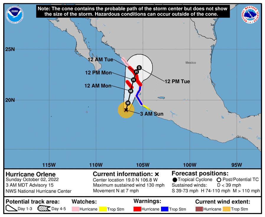
085939_5day_cone_with_line_and_wind.png
回復

使用道具 舉報

簽到天數: 3291 天

[LV.Master]伴壇終老

t02436|2022-10-2 23:17 | 顯示全部樓層
15Z強度略減至110節,即將登陸墨西哥
FORECAST POSITIONS AND MAX WINDS

INIT  02/1500Z 19.6N 106.9W  110 KT 125 MPH
12H  03/0000Z 20.6N 106.7W  100 KT 115 MPH
24H  03/1200Z 21.7N 106.4W   85 KT 100 MPH
36H  04/0000Z 22.6N 106.0W   70 KT  80 MPH
48H  04/1200Z 23.3N 105.7W   45 KT  50 MPH...INLAND
60H  05/0000Z 23.9N 105.4W   30 KT  35 MPH...INLAND
72H  05/1200Z...DISSIPATED

$$
Forecaster Brown

144739_5day_cone_with_line.png

goes17_truecolor_16E_202210021245.gif

GOES15002022275NB6T2t.jpg
回復

使用道具 舉報

快速回覆
您需要登錄後才可以回帖 登錄 | 立即加入

本版積分規則

本平台僅供學術討論之用,預報應以氣象局為準

威普網站虛擬主機贊助公司

臺灣第一個天氣類型社群平台 即時天氣資訊、精準颱風動態

線上客服
FB傳送訊息
廣告行銷
精準行銷 物超所值
官方粉專
發佈 快速回復 返回頂部 返回列表