簽到天數: 3291 天 [LV.Master]伴壇終老
|
 t02436|2022-7-26 22:14
|
顯示全部樓層
t02436|2022-7-26 22:14
|
顯示全部樓層
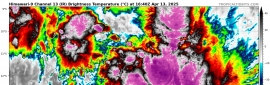
09Z升格07E

000
WTPZ42 KNHC 260856 CCA
TCDEP2
Tropical Depression Seven-E Discussion Number 1...Corrected
NWS National Hurricane Center Miami FL EP072022
400 AM CDT Tue Jul 26 2022
Conventional satellite imagery shows that deep convection associated
with the low pressure area south of southern Mexico has continued
to increase and become better organized. An earlier SSMIS
microwave overpass revealed an improved low-level structure,
although most of the deep convection was located over the western
portion of the system due to moderate easterly shear. A couple of
scatterometer overpasses between 0330 and 0500 UTC showed that the
circulation had become much better defined and the system had peak
winds around 30 kt. Subjective Dvorak T-numbers from SAB and TAFB
have also increased to T2.0, and based on all the above data,
advisories are being initiated on Tropical Depression Seven-E. The
initial wind speed is set at 30 kt, in agreement with both the
ASCAT data and the subjective Dvorak estimates.
Moderate easterly shear is forecast to plague the system over the
next 24 to 48 hours, however most of the intensity guidance
suggests gradual strengthening will occur during that time. The
official forecast follows suit and calls for the depression to
become a tropical storm later today or tonight. After 48 hours, the
shear is expected to abate while the system is over SSTs of 28-29C
and within a moist low- to mid-level environment. Those conditions
favor a faster rate of strengthening, and this is reflected in the
NHC forecast which shows the system becoming a hurricane in about 72
hours. The intensity forecast is in good agreement with the HCCA
and IVCN consensus aids and is also supported by the global model
guidance which depicts more significant deepening in 2-3 days.
The initial motion estimate is a somewhat uncertain 280/10 kt. The
cyclone is expected to continue westward for the next few days while
it is steered by a subtropical ridge that extends westward from
northern Mexico. After that time, the GFS and ECMWF models develop
a slight weakness in the ridge off the coast of Baja California
which allows the system to turn west-northwestward. The UKMET
depicts a stronger ridge and a more westward track than the
remainder of the guidance and its ensemble mean. As a result, the
official forecast is closer to a blend of the GFS and ECMWF models,
and a bit north and east of the TVCE multi-model consensus.
FORECAST POSITIONS AND MAX WINDS
INIT 26/0900Z 11.4N 101.8W 30 KT 35 MPH
12H 26/1800Z 11.8N 103.6W 35 KT 40 MPH
24H 27/0600Z 12.1N 105.6W 40 KT 45 MPH
36H 27/1800Z 12.2N 107.4W 45 KT 50 MPH
48H 28/0600Z 12.5N 109.1W 50 KT 60 MPH
60H 28/1800Z 12.8N 110.8W 60 KT 70 MPH
72H 29/0600Z 13.3N 112.6W 70 KT 80 MPH
96H 30/0600Z 14.9N 116.2W 80 KT 90 MPH
120H 31/0600Z 17.5N 119.7W 80 KT 90 MPH
$$
Forecaster Brown |
|


 提升卡
提升卡 千斤頂
千斤頂