開啟輔助訪問
 找回密碼
 立即加入

02L/04E.Bonnie 進入東太 風眼隱現

簽到天數: 601 天

[LV.9]以壇為家II

2022-6-24 10:23 | 顯示全部樓層
本帖最後由 霧峰追風者 於 2022-7-3 01:01 編輯

基本資料  
編號    :02 L
擾動編號日期:2022 06 24 08
撤編日期  :2022 06 00 00
94L.INVEST.15kts-1012mb-6.9N-23.6W
20220624.0000.goes-16.ir.94L.INVEST.15kts.1012mb.7N.23.3W.100pc.jpg
1. Tropical Atlantic:
A tropical wave located over the eastern tropical Atlantic continues
to produce disorganized showers and thunderstorms. This activity has
become a bit more concentrated this evening, and environmental
conditions appear conducive for additional development over the next
few days. A tropical depression could form by early next week as
this system moves westward at around 15 mph over the tropical
Atlantic.
* Formation chance through 48 hours...low...20 percent.
* Formation chance through 5 days...medium...40 percent.

two_atl_2d1.png

評分

參與人數 1水氣能量 +15 +1 收起 理由
周子堯@FB + 15 + 1 熱帶擾動首帖

查看全部評分

回復

使用道具 舉報

簽到天數: 601 天

[LV.9]以壇為家II

霧峰追風者|2022-6-28 10:25 | 顯示全部樓層
233515_5day_cone_no_line_and_wind.png
850
WTNT42 KNHC 272046
TCDAT2

Potential Tropical Cyclone Two Discussion Number   1
NWS National Hurricane Center Miami FL       AL022022
500 PM AST Mon Jun 27 2022

A NOAA Hurricane Hunter aircraft just investigated the tropical
wave to the east-southeast of the Windward Islands, and found that
the system has not yet developed a closed circulation.  However the
plane did find an area of tropical-storm-force winds over the
northern portion of the system.  The disturbance is producing some
cells of strong convection, but overall the system is not very well
organized.  Since there is a good chance that the disturbance
will become a tropical storm before reaching the southern Windward
Islands, advisories are being initiated on Potential Tropical
Cyclone Two.  The environment looks fairly favorable for
development, but the numerical guidance is generally not that
bullish on strengthening for the next couple of days.  The official
intensity forecast is similar to the correct consensus model, HCCA.

Although the center is not well defined, my best estimate of the
initial motion is about 285/16 kt.  A strong 500 mb subtropical
ridge is likely to remain in place to the north of the system
through the forecast period.  This steering scenario should cause a
west-northwestward to westward track for the next several days.
The official track forecast is close to the dynamical model
consensus.


KEY MESSAGES:

1.  Heavy rainfall is expected over the Windward Islands and
northeastern Venezuela Tuesday night and into Wednesday.

2.  Winds to tropical storm force are expected over portions of the
southern Windward Islands beginning late Tuesday and into Wednesday.


FORECAST POSITIONS AND MAX WINDS

INIT  27/2100Z  8.6N  50.9W   35 KT  40 MPH...POTENTIAL TROP CYCLONE
12H  28/0600Z  9.3N  53.5W   35 KT  40 MPH...POTENTIAL TROP CYCLONE
24H  28/1800Z 10.1N  57.3W   40 KT  45 MPH...TROPICAL CYCLONE
36H  29/0600Z 10.8N  61.4W   40 KT  45 MPH
48H  29/1800Z 11.4N  65.5W   45 KT  50 MPH
60H  30/0600Z 11.8N  69.1W   45 KT  50 MPH
72H  30/1800Z 12.1N  72.7W   60 KT  70 MPH
96H  01/1800Z 12.2N  79.0W   65 KT  75 MPH
120H  02/1800Z 12.3N  84.4W   55 KT  65 MPH...INLAND

$$
Forecaster Pasch


回復

使用道具 舉報

簽到天數: 601 天

[LV.9]以壇為家II

霧峰追風者|2022-7-2 10:08 | 顯示全部樓層
000
WTNT42 KNHC 011455
TCDAT2

Tropical Storm Bonnie Discussion Number  16
NWS National Hurricane Center Miami FL       AL022022
1100 AM EDT Fri Jul 01 2022

Tropical Storm Bonnie has formed this morning over the western
Caribbean Sea. Well-organized deep convection has persisted into
the morning, and an Air Force Reserve Hurricane Hunter mission
found a well-defined circulation center located about 100 n mi east
of the Nicaragua coast. The plane found flight-level winds of 44
kt in the northeast quadrant, and SFMR data indicated 33 kt surface
winds, supporting an initial intensity of 35 kt. Another
reconnaissance mission is scheduled later today.

Bonnie is moving just south of due west at 260/17 kt and has
tracked slightly farther south than the prior forecast. The storm
is expected to make landfall late tonight near the Nicaragua and
Costa Rica border. After traversing Central America, Bonnie is
expected to emerge over the eastern Pacific waters on Saturday, and
it is forecast to turn west-northwestward shortly thereafter and
track parallel to the coast of Central America and Mexico for the
next several days. The track guidance is in good agreement during
the forecast period, with the ECMWF still the northernmost solution
and closest to land, while remaining offshore. The new forecast is
slightly south of the previous forecast, partially based on the
initial motion and position. Given the expected proximity to land,
interests in coastal El Salvador, Guatemala and southwestern Mexico
should continue to monitor Bonnie's progress during the next
several days.

Bonnie remains in a low-shear and warm SST environment and is
forecast to intensify during the next 12 hours prior to landfall.
The official intensity forecast at 12 hours is at the high end of
the intensity guidance. After Bonnie emerges into the eastern
Pacific, the intensity forecast is similar to the prior forecast and
aligned with the consensus intensity guidance for the remainder of
the forecast period.


KEY MESSAGES:

1. Heavy rainfall is likely across portions of Nicaragua and Costa
Rica today into Saturday. Areas of life-threatening flash flooding
and mudslides are expected.

2. Tropical storm conditions are expected on San Andres today,
along the Caribbean coasts of Costa Rica and Nicaragua within the
Tropical Storm Warning areas by this evening, and along the Pacific
coasts of Costa Rica and Nicaragua overnight and early Saturday.


FORECAST POSITIONS AND MAX WINDS

INIT  01/1500Z 11.2N  81.0W   35 KT  40 MPH
12H  02/0000Z 11.0N  83.0W   45 KT  50 MPH
24H  02/1200Z 11.0N  85.6W   35 KT  40 MPH...INLAND
36H  03/0000Z 11.1N  88.0W   40 KT  45 MPH...OVER WATER
48H  03/1200Z 11.7N  90.5W   45 KT  50 MPH
60H  04/0000Z 12.5N  93.3W   50 KT  60 MPH
72H  04/1200Z 13.4N  96.2W   60 KT  70 MPH
96H  05/1200Z 15.1N 102.2W   65 KT  75 MPH
120H  06/1200Z 16.3N 107.2W   70 KT  80 MPH

$$
Forecaster Hogsett/Cangialosi
145700_5day_cone_with_line_and_wind.png recon_AF305-0802A-INVEST.png
回復

使用道具 舉報

簽到天數: 3279 天

[LV.Master]伴壇終老

t02436|2022-7-2 17:30 | 顯示全部樓層
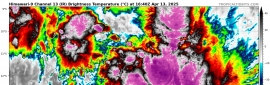
09Z報中心在尼加拉瓜湖,持續西行,即將進入東太平洋,二次巔峰暫時上望75節不封頂。
000
WTNT42 KNHC 020858
TCDAT2

Tropical Storm Bonnie Discussion Number  19
NWS National Hurricane Center Miami FL       AL022022
400 AM CDT Sat Jul 02 2022

Overall, Bonnie's structure is holding together quite well as the
storm moves across Central America. While the coldest cloud tops
near the center have warmed somewhat, radar from the Nicaraguan
Weather Service in Las Nubes shows a healthy reflectivity structure.
In fact, after the last center fix the Air Force Reserve Hurricane
Hunter aircraft made indicated a formative eyewall was developing
with Bonnie, a similar signature is now also currently observed with
Bonnie over Lake Nicaragua. Assuming there has been some weakening
of the wind field since Bonnie began moving over land, the
intensity is being reduced to an uncertain 35 kt for this advisory.

Bonnie was moving just north of due west from the recon fixes last
night, and the initial motion has been maintained at 275/14 kt. A
strong deep-layer ridge poleward of Bonnie should continue to steer
the cyclone west to west-northwestward for the majority of the
forecast period after it moves offshore. This track continues to
take Bonnie roughly parallel to the southern coast of Central
America and Mexico. The track guidance remains in good agreement
this cycle, and only slight changes to the forecast track were made,
mostly a somewhat faster motion at the end of the forecast period.
While the relatively small size of the tropical cyclone is currently
forecast to keep the highest winds offshore, interests in coastal El
Salvador, Guatemala, and southwestern Mexico should continue to
monitor Bonnie's track for the next few days, as any northward track
adjustments could require tropical storm watches for portions of
this coastline.

So far Bonnie's structure does not appear to be that adversely
affected by its ongoing land interaction crossing Central America,
perhaps because it is traversing a relatively flat gap across Lake
Nicaragua, in between higher terrain to its north or south. However,
one thorn in the system's short-term intensity forecast is that sea
surface temperatures (SSTs) just offshore Nicaragua are not all that
warm, only between 26-27 C with a very shallow depth of these
marginally warm waters for the first 24 h or so. For this reason,
only slow intensification is forecasted early on, which is under the
majority of the guidance in this time frame. Afterwards, SSTs
markedly warm to above 28 C, and vertical wind shear is expected to
remain only light to moderate. Thus, a faster rate of
intensification is anticipated after 36 h, and Bonnie is still
forecast to become a hurricane in about three days. The latest
intensity forecast has been adjusted downward in the short-term, but
still peaks the storm as a 75-kt hurricane at the end of the
forecast period.

It is worth mentioning that Bonnie's low-level circulation is
expected to survive its passage across Central America, similar to
that of Hurricane Otto back in 2016. Thus, the system is expected to
retain its name even after it moves into the far eastern Pacific
later today.  The intermediate advisory at 1200 UTC will be issued
under the same Atlantic header as before.  Product headers will
change to eastern Pacific headers beginning with the next complete
advisory at 1500 UTC, with the ATCF identifier changing from
AL022022 to EP042022.


KEY MESSAGES:

1. Heavy rainfall is expected across portions of Nicaragua and
Costa Rica today. Life-threatening flash flooding and mudslides are
expected.

2. Tropical storm conditions are expected along the Caribbean
coasts of Costa Rica and Nicaragua within the Tropical Storm Warning
areas for the next several hours, and along the Pacific coasts of
Costa Rica and Nicaragua today.


FORECAST POSITIONS AND MAX WINDS

INIT  02/0900Z 11.3N  85.1W   35 KT  40 MPH...OVER LAKE NICARAGUA
12H  02/1800Z 11.3N  87.1W   35 KT  40 MPH...OVER PACIFIC OCEAN
24H  03/0600Z 11.5N  89.4W   40 KT  45 MPH
36H  03/1800Z 12.0N  91.9W   45 KT  50 MPH
48H  04/0600Z 13.0N  95.0W   55 KT  65 MPH
60H  04/1800Z 13.9N  98.0W   60 KT  70 MPH
72H  05/0600Z 14.7N 101.0W   65 KT  75 MPH
96H  06/0600Z 16.0N 106.4W   75 KT  85 MPH
120H  07/0600Z 16.4N 110.5W   75 KT  85 MPH

$$
Forecaster Papin

085756_5day_cone_with_line.png

GOES09102022183RqJYd6.jpg
回復

使用道具 舉報

簽到天數: 3279 天

[LV.Master]伴壇終老

t02436|2022-7-3 14:50 | 顯示全部樓層
已改編號為04E,巔峰上望80節。
ep0422.gif
668
WTPZ44 KNHC 030323
TCDEP4

Tropical Storm Bonnie Discussion Number  22...Retransmitted
NWS National Hurricane Center Miami FL       EP042022
1000 PM CDT Sat Jul 02 2022

This evening's conventional satellite presentation consists of an
impressive deep convective curved band with -83C cloud tops
encompassing the west side of the cyclone.  Earlier SSM/S and AMSR2
microwave passes revealed inner core ring development that was about
60 percent closed in the northern quadrants.  There appears to be a
slight vertical tilt toward the west, more than likely due to the
period it spent moving across Nicaragua.  The initial intensity is
raised to 50 kt and is based on a compromise of the various
subjective and objective satellite intensity estimates.

The shear is low, the water is warm, and the atmosphere is moist,
all contributing to further strengthening during the next few days,
and Bonnie is expected to become a hurricane in 24 hours.  Around
mid-period, the global models and the GFS/ECMWF SHIPS intensity
guidance show modest northeasterly shear impinging on Bonnie's
outflow pattern.  As a result, the official intensity forecast
calls for a slight weakening beyond day 3.

Bonnie's initial motion is estimated to be due west or 270/15 kt.
A mid-tropospheric ridge stretching from the northern Gulf of
Mexico to the Baja California peninsula should cause the cyclone to
turn west-northwestward Sunday and continue in this heading through
the remainder of the forecast period.  The global and regional
model track guidance remains in agreement, and these tightly
clustered aids, as well as the NHC forecast, takes Bonnie
approximately parallel to the coasts and keeps the
tropical-storm-force winds offshore of the southern coast of
Central America and Mexico. However, interests in coastal El
Salvador, Guatemala, and southwestern Mexico should closely monitor
Bonnie's forecast track for the next few days as a slight northward
adjustment to the track could require tropical storm watches for
portions of this coastline.


KEY MESSAGES:

1. Areas of heavy rainfall are expected across portions of
Nicaragua, Costa Rica and the southern portion of El Salvador
through tonight.  This rainfall may cause some instances of flash
flooding and mudslides across the region.

2. Interests along the coasts of Honduras, El Salvador, Guatemala,
and southeastern Mexico should monitor the progress of this system.
While the center of Bonnie is forecast to stay offshore, any
northward adjustment in the track forecast could require the
issuance of a tropical storm watch for part of this area.


FORECAST POSITIONS AND MAX WINDS

INIT  03/0300Z 11.3N  89.5W   50 KT  60 MPH
12H  03/1200Z 11.6N  91.4W   55 KT  65 MPH
24H  04/0000Z 12.4N  94.2W   65 KT  75 MPH
36H  04/1200Z 13.2N  97.1W   70 KT  80 MPH
48H  05/0000Z 14.1N 100.2W   75 KT  85 MPH
60H  05/1200Z 15.1N 103.2W   80 KT  90 MPH
72H  06/0000Z 15.6N 105.8W   75 KT  85 MPH
96H  07/0000Z 15.9N 110.2W   70 KT  80 MPH
120H  08/0000Z 16.3N 114.3W   70 KT  80 MPH

$$
Forecaster Roberts

023619_5day_cone_with_line.png

GOES06302022184SZ2Nn0.jpg
回復

使用道具 舉報

快速回覆
您需要登錄後才可以回帖 登錄 | 立即加入

本版積分規則

霧峰追風者

    主題

    帖子

    220萬

    積分

    16級[四級颶風]

    Rank: 16Rank: 16Rank: 16Rank: 16

16級[四級颶風]

發訊息

本平台僅供學術討論之用,預報應以氣象局為準

威普網站虛擬主機贊助公司

臺灣第一個天氣類型社群平台 即時天氣資訊、精準颱風動態

線上客服
FB傳送訊息
廣告行銷
精準行銷 物超所值
官方粉專
發佈 快速回復 返回頂部 返回列表