簽到天數: 2141 天 [LV.Master]伴壇終老
|
 周子堯@FB|2022-3-14 16:33
|
顯示全部樓層
周子堯@FB|2022-3-14 16:33
|
顯示全部樓層
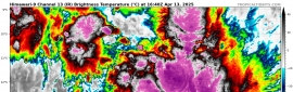
補BOM編號報文
IDW23100
40:2:2:24:12S105E400:11:00
SECURITE
OCEAN WIND WARNING FOR METAREA 10
Issued by the Australian Bureau of Meteorology
Tropical Cyclone Warning Centre
at 0637 UTC 13 MARCH 2022
GALE WARNING
Please be aware, wind gusts can be a further 40 percent stronger than the
averages given here, and maximum waves may be up to twice the height.
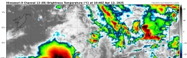
SITUATION
At 0600 UTC a Tropical Low was centred within 45 nautical miles of
latitude twelve decimal five south (12.5S)
longitude one hundred and five decimal zero east (105.0E)
Recent movement : southwest at 11 knots
Maximum winds : 25 knots
Central pressure: 1002 hPa
The low is not expected to develop into a tropical cyclone in the next 24
hours, however gales may develop in the southern semicircle after 0000 UTC 14
March.
AREA AFFECTED
Within 90 nautical miles of the centre in the southern semicircle after 0000
UTC 14 March.
FORECAST
Maximum winds to 25 knots near the centre increasing to 35 knots after 0000 UTC
14 March.
After 0000 UTC 14 March winds above 34 knots within 90 nautical miles of centre
in the southern semicircle, with rough seas and moderate swell.
Forecast positions
At 1800 UTC 13 March: Within 65 nautical miles of 13.5 south 103.2 east
Central pressure 1002 hPa.
Winds to 30 knots near centre.
At 0600 UTC 14 March: Within 70 nautical miles of 14.6 south 101.1 east
Central pressure 999 hPa.
Winds to 35 knots near centre.
REMARKS
All ships in the area please send weather reports every three hours.
Regular weather observing ships use normal channels.
Other ships please use email to tcwc@bom.gov.au.
Next warning will be issued by 1300 UTC 13 March 2022.
AUSTRALIAN BUREAU OF METEOROLOGY
TROPICAL CYCLONE WARNING CENTRE 
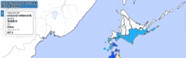
Time (AWST) Intensity Category Latitude
(decimal deg.) Longitude
(decimal deg.) Estimated Position
Accuracy (km)
0hr 2 pm March 13 tropical low 12.5S 105.0E 85
+6hr 8 pm March 13 tropical low 13.0S 104.1E 110
+12hr 2 am March 14 tropical low 13.5S 103.2E 125
+18hr 8 am March 14 tropical low 14.1S 102.2E 125
+24hr 2 pm March 14 tropical low 14.6S 101.1E 130
+36hr 2 am March 15 tropical low 15.4S 99.3E 135
+48hr 2 pm March 15 tropical low 16.0S 97.7E 170
+60hr 2 am March 16 1 16.3S 96.0E 215
+72hr 2 pm March 16 1 16.9S 94.1E 270
|
|


 提升卡
提升卡 千斤頂
千斤頂