開啟輔助訪問
 找回密碼
 立即加入

96L 溫氣 一度發布TCFA

簽到天數: 1650 天

[LV.Master]伴壇終老

2021-11-10 09:39 | 顯示全部樓層
  基本資料  
編號               :96 L
擾動編號日期 :2021 11 10 08
撤編日期        :2021 11 12 08
96L.INVEST.60kts.982mb.35.3N.60.2W

sm20211110.0040.goes-16.ir.96L.INVEST.60kts.982mb.35.3N.60.2W.100pc.jpg
NHC:30%
1. Showers and thunderstorms associated with a storm-force non-tropical
low centered about 300 miles northeast of Bermuda have become better
organized since this morning.  As the low moves eastward and then
northeastward during the next couple of days, some additional
development is possible while the system remains over relatively
warm water south of the Gulf Stream.  After that time, the system is
forecast to be absorbed by another non-tropical low.  Additional
information on this system can be found in High Seas forecasts
issued by the National Weather Service.
* Formation chance through 48 hours...low...30 percent.
* Formation chance through 5 days...low...30 percent.

two_atl_2d1 (9).png two_atl_5d1 (8).png

評分

參與人數 1水氣能量 +15 +1 收起 理由
t02436 + 15 + 1

查看全部評分

回復

使用道具 舉報

簽到天數: 1650 天

[LV.Master]伴壇終老

老農民版夜神月|2021-11-10 12:18 | 顯示全部樓層
NHC展望提升至Medium,50%
1. Showers and thunderstorms associated with a strong non-tropical low
centered about 350 miles northeast of Bermuda continue to show signs
of organization.  In addition, recent satellite wind data indicate
that winds of near hurricane force are occurring south of the
center.  This system has not yet acquired enough tropical cyclone
characteristics to be considered a subtropical storm.  However,
additional development is possible during the next day or two, and a
subtropical storm could form during this time.  After that time, the
system is forecast to move over colder water and become absorbed by
another non-tropical low.  Additional information on this system can
be found in High Seas forecasts issued by the National Weather
Service.
* Formation chance through 48 hours...medium...50 percent.
* Formation chance through 5 days...medium...50 percent.

two_atl_2d1 (2).png two_atl_5d1 (3).png 96L_gefs_latest.png
回復

使用道具 舉報

簽到天數: 1650 天

[LV.Master]伴壇終老

老農民版夜神月|2021-11-11 02:03 | 顯示全部樓層
"一級溫帶氣旋"96L
96L INVEST 211110 1200 35.9N 56.3W ATL 70 982
20211110.1700.goes-16.ir.96L.INVEST.70kts.982mb.35.9N.56.3W.100pc.jpg 20211110.1640.goes-16.vis.2km.96L.INVEST.70kts.982mb.35.9N.56.3W.pc.jpg 20211110.1417.mtb.ASCAT.wind.96L.INVEST.70kts-982mb.359N.563W.25km.noqc.jpg 20211110.1707.gw1.89pct89h89v.96L.INVEST.70kts.982mb.35.9N.56.3W.82pc.jpg
回復

使用道具 舉報

簽到天數: 1650 天

[LV.Master]伴壇終老

老農民版夜神月|2021-11-11 15:38 | 顯示全部樓層
本帖最後由 老農民版夜神月 於 2021-11-11 15:40 編輯

FWC-N於昨晚其實有發TCFA
SUBJ/TROPICAL CYCLONE FORMATION ALERT (96L) //
WTNT21 KNGU 101900
1. FORMATION OF A TROPICAL CYCLONE IS POSSIBLE WITHIN 100 NM EITHER
SIDE OF A LINE FROM 35.9N 56.3W TO 41.1N 43.8W WITHIN THE NEXT 12 TO
24 HOURS. AVAILABLE DATA DOES NOT JUSTIFY ISSUANCE OF NUMBERED
TROPICAL CYCLONE WARNINGS AT THIS TIME. WINDS IN THE AREA ARE
ESTIMATED TO BE 60 TO 70 KNOTS. METSAT IMAGERY AT 101900Z INDICATES
THAT A CIRCULATION CENTER IS LOCATED NEAR 35.9N 56.3W. THE SYSTEM IS
MOVING EAST-NORTHEASTWARD AT 27 KNOTS.
2. REMARKS:MAXIMUM SUSTAINED SURFACE WINDS ARE ESTIMATED AT 60 TO
70 KNOTS. RECENT CONVENTIONAL SATELLITE IMAGES INDICATE THAT SHOWERS
AND THUNDERSTORMS ASSOCIATED WITH A HURRICANE-FORCE NON-TROPICAL LOW
PRESSURE SYSTEM LOCATED A LITTLE OVER 500 MILES EAST-NORTHEAST OF
BERMUDA ARE SHOWING SIGNS OF ORGANIZATION. ADDITIONAL DEVELOPMENT
IS POSSIBLE AND A SUBTROPICAL STORM COULD FORM DURING THE NEXT 24
HOURS WHILE UPPER-LEVEL WINDS BECOME A LITTLE MORE FAVORABLE FOR
DEVELOPMENT.
3. THIS ALERT WILL BE REISSUED, UPGRADED TO
WARNING OR CANCELLED BY 111900Z. //
BT

al962021.gif 96L_gefs_latest (1).png
回復

使用道具 舉報

簽到天數: 1650 天

[LV.Master]伴壇終老

老農民版夜神月|2021-11-12 00:11 | 顯示全部樓層
NHC展望調降至Low,30%
1. Showers and thunderstorms associated with a storm-force non-tropical
area of low pressure located more than 1000 miles east-northeast of
Bermuda have changed little in organization since last night.
Although there is still a small chance the system could become a
short-lived subtropical storm today, the system is quickly moving
over cooler waters and the likelihood of subtropical development has
decreased. By this weekend, the system is expected to be absorbed by
a larger non-tropical low. Additional information on this system,
including hurricane-force wind warnings, can be found in High Seas
forecasts issued by the National Weather Service.
* Formation chance through 48 hours...low...30 percent.
* Formation chance through 5 days...low...30 percent.

two_atl_2d1 (56).png two_atl_5d1 (57).png 96L_gefs_latest (3).png
回復

使用道具 舉報

簽到天數: 1650 天

[LV.Master]伴壇終老

老農民版夜神月|2021-11-12 01:54 | 顯示全部樓層
NHC展望再降至10%,如此看來FWC-N19Z也不可能再續發TCFA了
1. A large and powerful non-tropical area of low pressure located
several hundred miles southeast of Cape Race Newfoundland is
producing a broad area of showers, gale to near-hurricane-force
winds, and dangerous seas across portions of the north-central
Atlantic. Although the chance for subtropical development continues
to decrease as it moves over much cooler waters, this system is
forecast to intensify into a hurricane-force extratropical low by
tonight. Additional information on this system, including
hurricane-force wind warnings, can be found in High Seas forecasts
issued by the National Weather Service.
* Formation chance through 48 hours...low...10 percent.
* Formation chance through 5 days...low...10 percent.
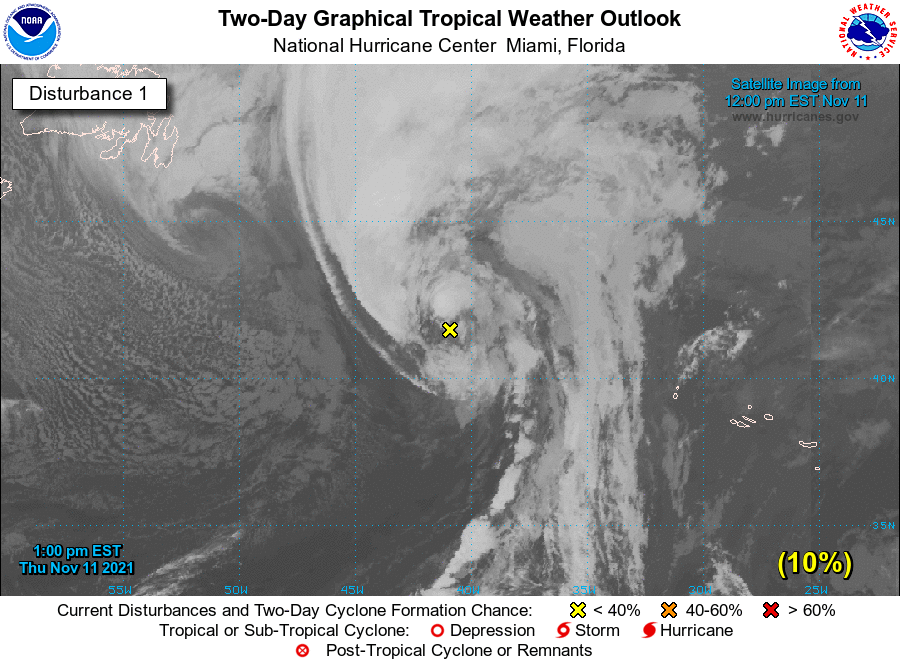
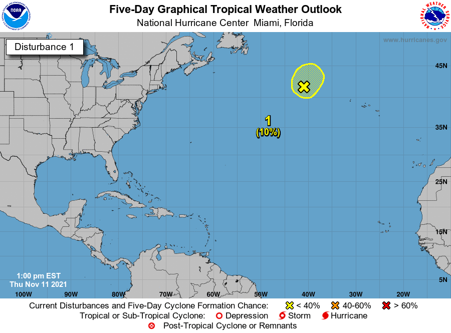
two_atl_2d1 (57).png two_atl_5d1 (58).png
回復

使用道具 舉報

簽到天數: 1650 天

[LV.Master]伴壇終老

老農民版夜神月|2021-11-12 13:34 | 顯示全部樓層
NHC已不再對其發布展望
ZCZC MIATWOAT ALL
TTAA00 KNHC DDHHMM

Tropical Weather Outlook
NWS National Hurricane Center Miami FL
100 AM EST Fri Nov 12 2021

For the North Atlantic...Caribbean Sea and the Gulf of Mexico:

Tropical cyclone formation is not expected during the next 5 days.

$$
Forecaster Beven

NNNN
two_atl_2d0 (22).png two_atl_5d0 (10).png
回復

使用道具 舉報

快速回覆
您需要登錄後才可以回帖 登錄 | 立即加入

本版積分規則

本平台僅供學術討論之用,預報應以氣象局為準

威普網站虛擬主機贊助公司

臺灣第一個天氣類型社群平台 即時天氣資訊、精準颱風動態

線上客服
FB傳送訊息
廣告行銷
精準行銷 物超所值
官方粉專
發佈 快速回復 返回頂部 返回列表