開啟輔助訪問
 找回密碼
 立即加入

92L

簽到天數: 1650 天

[LV.Master]伴壇終老

2021-10-7 20:09 | 顯示全部樓層
  基本資料  
編號               :92 L
擾動編號日期 :2021 10 07 20
撤編日期        :2021 10
11 08

92L.INVEST. 20kts-31.0N-79.3W-1016mb
20211007.115032.AL922021.abi.goes-17.WV.20kts.65p4.1p0 (1).jpg

NHC:10%
1. A weak area of low pressure located about 100 miles off the coasts
of Georgia and South Carolina continues to produce disorganized
showers and thunderstorms, well to the northeast of the center of
circulation.  Strong upper-level winds should limit significant
tropical or subtropical development during the next few days while
the low moves northeastward at about 5 mph off the coasts of the
Carolinas.  Some non-tropical development will be possible over the
weekend due to the system interacting with a frontal boundary.  
Regardless of development, this system could bring gusty winds and
locally heavy rain to portions of the Carolinas through the weekend.
* Formation chance through 48 hours...low...10 percent.
* Formation chance through 5 days...low...20 percent.

two_atl_2d1 (7).png two_atl_5d1 (6).png


評分

參與人數 1水氣能量 +15 +1 收起 理由
king111807 + 15 + 1 熱帶擾動首帖

查看全部評分

回復

使用道具 舉報

簽到天數: 3198 天

[LV.Master]伴壇終老

king111807|2021-10-8 02:08 | 顯示全部樓層
NHC展望提升至20%
1. A low pressure area located about 100 miles off the coast of South
Carolina continues to produce disorganized showers and
thunderstorms to the east of its center of circulation.  Although
upper-level winds are expected to be strong during the next few
days, some tropical or subtropical development will be possible
through the weekend before the low interacts with a frontal boundary
located to its north.  The low is forecast to move slowly
east-northeastward at about 5 mph, and it could bring gusty winds
and locally heavy rain to eastern portions of the Carolinas through
the weekend, regardless of development.
* Formation chance through 48 hours...low...20 percent.
* Formation chance through 5 days...low...30 percent.
two_atl_2d1.png
回復

使用道具 舉報

簽到天數: 601 天

[LV.9]以壇為家II

霧峰追風者|2021-10-9 10:19 | 顯示全部樓層
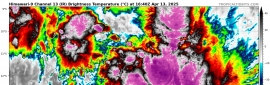
1. A nearly stationary area of low pressure located about 200 miles
south of Cape Hatteras, North Carolina continues to produce
disorganized showers and thunderstorms. Environmental conditions
could briefly become marginally conducive for the low to acquire
subtropical characteristics by Saturday night and early Sunday. By
early next week, environmental conditions should become unfavorable
for any further development. The low is forecast to begin moving
slowly toward the west-northwest tonight and then northwest on
Saturday, bringing the system closer to the coasts of the Carolinas.
Therefore, interests along these coasts should monitor the progress
of this system.

Regardless of development, intermittent periods of locally heavy
rains and gusty winds will affect eastern portions of the Carolinas
through the weekend. An Air Force Reserve reconnaissance aircraft is
scheduled to investigate the system Saturday afternoon, if
necessary.  Additional information on this system, including gale
warnings, can be found in High Seas Forecasts issued by the National
Weather Service.
* Formation chance through 48 hours...medium...40 percent.
* Formation chance through 5 days...medium...40 percent.
two_atl_2d1.png
回復

使用道具 舉報

簽到天數: 3198 天

[LV.Master]伴壇終老

king111807|2021-10-10 11:05 | 顯示全部樓層
NHC展望提升至50%
1. An Air Force Reserve reconnaissance unit aircraft has recently been
flying through the large non-tropical low pressure area located
about 100 miles southeast of Morehead City, North Carolina.  While
the low is producing a broad area of gale-force winds to the north
and east of the center, the plane did not find a well-defined
center, and the associated shower and thunderstorm activity has not
become any better organized today.  This system could still become
a short-lived subtropical storm through Sunday, but environmental
conditions should become unfavorable for any further development on
Monday.  The low is forecast to move slowly northwestward and
approach eastern North Carolina tonight and early Sunday.  
Interests in that area should monitor the progress of this system
and refer to local National Weather Service office products for
more information.  Regardless of development, intermittent periods
of locally heavy rains and gusty winds will affect southeastern and
eastern portions of North Carolina during the next day or two.   
Additional information on this low pressure system, including gale
warnings, can be found in High Seas Forecasts issued by the National
Weather Service.
* Formation chance through 48 hours...medium...50 percent.
* Formation chance through 5 days...medium...50 percent.
two_atl_2d1.png
回復

使用道具 舉報

簽到天數: 3198 天

[LV.Master]伴壇終老

king111807|2021-10-10 21:19 | 顯示全部樓層
NHC展望降至Low,30%
1. Shower and thunderstorm activity has decreased and become less
organized in association with a large non-tropical low pressure area
located about 90 miles southeast of Morehead City, North Carolina.
Earlier satellite wind data indicated that the system was producing
an area of gale-force winds in its northern semicircle offshore the
North Carolina coast. However, dry air and strong upper-level winds
are beginning to decrease the chance for further development of this
system. The low is forecast to move slowly north-northeastward and
approach eastern North Carolina later today.  Interests in that area
should monitor the progress of this system and refer to local
National Weather Service office products for more information.
Regardless of development, intermittent periods of locally heavy
rains and gusty winds will affect southeastern and eastern portions
of North Carolina during the next day or two.  Additional
information on this low pressure system, including gale warnings,
can be found in High Seas Forecasts issued by the National Weather
Service.
* Formation chance through 48 hours...low...30 percent.
* Formation chance through 5 days...low...30 percent.
two_atl_2d1.png
回復

使用道具 舉報

簽到天數: 3198 天

[LV.Master]伴壇終老

king111807|2021-10-11 13:01 | 顯示全部樓層
NHC展望降至10%
1. A non-tropical low pressure area located about 75 miles south of
Cape Hatteras, North Carolina, continues to produce disorganized
showers and a few thunderstorms.  Recent radar and satellite imagery
indicates that the circulation of the low has become less defined
since this morning. Dry air and strong upper-level winds are
expected to prevent any further development of this system while
it moves slowly northward or north-northeastward through Monday.
Regardless of development, locally heavy rainfall and gusty winds
are still possible over portions of the North Caroling Outer Banks
through Monday and information on these hazards can be found in
products issued by your local National Weather Service Office.
Additional information on this low pressure system, including gale
warnings, can be found in High Seas Forecasts issued by the National
Weather Service.
* Formation chance through 48 hours...low...10 percent.
* Formation chance through 5 days...low...10 percent.
two_atl_2d1.png
回復

使用道具 舉報

簽到天數: 3198 天

[LV.Master]伴壇終老

king111807|2021-10-11 19:47 | 顯示全部樓層
NHC展望降至0%
1. A non-tropical low pressure area located just off the North
Carolina coast continues to produce some disorganized showers and
thunderstorms.  Although this system is not expected to become a
tropical or subtropical cyclone, locally heavy rainfall and gusty
winds are still possible over portions of the North Carolina Outer
Banks today and information on these hazards can be found in
products issued by your local National Weather Service Office.
Additional information on this low pressure system, including gale
warnings, can be found in High Seas Forecasts issued by the National
Weather Service.
* Formation chance through 48 hours...low...near 0 percent.
* Formation chance through 5 days...low...near 0 percent.
two_atl_2d1.png
回復

使用道具 舉報

快速回覆
您需要登錄後才可以回帖 登錄 | 立即加入

本版積分規則

本平台僅供學術討論之用,預報應以氣象局為準

威普網站虛擬主機贊助公司

臺灣第一個天氣類型社群平台 即時天氣資訊、精準颱風動態

線上客服
FB傳送訊息
廣告行銷
精準行銷 物超所值
官方粉專
發佈 快速回復 返回頂部 返回列表