開啟輔助訪問
 找回密碼
 立即加入

97E

簽到天數: 601 天

[LV.9]以壇為家II

2021-9-12 02:20 | 顯示全部樓層
基本資料  
編號    :97 E
擾動編號日期:2021 09 12 02
撤編日期  :2021 09 14 08
97E.INVEST.15kts-1007mb-13N-98W
20210911.1740.goes-16.ir.97E.INVEST.15kts.1007mb.13N.98W.100pc.jpg
1. A broad area of low pressure offshore southern Mexico is producing a
large area of disorganized showers and thunderstorms.  Some gradual
development of this system is possible during the next couple of
days as long as it remains over water, and a tropical depression
could form tomorrow or early Monday while the system moves
northwestward or north-northwestward toward the southern and
southwestern coasts of Mexico.  Thereafter, further development is
not expected due to interaction with land.  Regardless of
development, this system will likely produce heavy rains across
portions of southern Mexico during the next couple of days.
* Formation chance through 48 hours...medium...60 percent.
* Formation chance through 5 days...medium...60 percent.

two_pac_2d1.png


評分

參與人數 1水氣能量 +15 +1 收起 理由
king111807 + 15 + 1 熱帶擾動首帖

查看全部評分

回復

使用道具 舉報

簽到天數: 1650 天

[LV.Master]伴壇終老

老農民版夜神月|2021-9-12 16:38 | 顯示全部樓層
本帖最後由 老農民版夜神月 於 2021-9-12 16:46 編輯

JTWC發布TCFA ep9721 (2).gif 97E_120000sair.jpg 97E_gefs_latest.png

WTPN21 PHNC 112300
MSGID/GENADMIN/JOINT TYPHOON WRNCEN PEARL HARBOR HI//
SUBJ/TROPICAL CYCLONE FORMATION ALERT (INVEST 97E)//
RMKS/
1. FORMATION OF A SIGNIFICANT TROPICAL CYCLONE IS POSSIBLE WITHIN
175 NM EITHER SIDE OF A LINE FROM 11.5N 97.7W TO 15.5N 100.0W
WITHIN THE NEXT 12 TO 24 HOURS. AVAILABLE DATA DOES NOT JUSTIFY
ISSUANCE OF NUMBERED TROPICAL CYCLONE WARNINGS AT THIS TIME.
WINDS IN THE AREA ARE ESTIMATED TO BE 20 TO 25 KNOTS. METSAT
IMAGERY AT 111800Z INDICATES THAT A CIRCULATION CENTER IS LOCATED
NEAR 11.5N 97.7W. THE SYSTEM IS MOVING NORTH-NORTHWESTWARD AT 04
KNOTS.
2. REMARKS: AN AREA OF CONVECTION (INVEST 97E) HAS PERSISTED NEAR
11.5N 97.7W, APPROXIMATELY 1665 NM SOUTHEAST OF SAN DIEGO. ANIMATED
MULTISPECTRAL SATELLITE IMAGERY DEPICTS A NARROW BAND OF DEEP
CONVECTION WRAPPING INTO A BROAD LOW LEVEL CIRCULATION CENTER. UPPER
LEVEL ANALYSIS INDICATES THE DISTURBANCE IS LOCATED UNDER AN AREA OF
BROAD DIFFLUENCE WITH LOW TO MODERATE VERTICAL WIND SHEAR. GLOBAL
MODELS INDICATE THAT THE SYSTEM WILL SLOWLY DEVELOP AS IT TRACKS
TOWARDS THE COAST OF SOUTHERN MEXICO. MAXIMUM SUSTAINED SURFACE
WINDS ARE ESTIMATED AT 20 TO 25 KNOTS. MINIMUM SEA LEVEL PRESSURE IS
ESTIMATED TO BE NEAR 1004 MB. THE POTENTIAL FOR THE DEVELOPMENT OF A
SIGNIFICANT TROPICAL CYCLONE WITHIN THE NEXT 24 HOURS IS HIGH.
3. THIS ALERT WILL BE REISSUED, UPGRADED TO WARNING OR CANCELLED BY
122300Z.//
NNNN

回復

使用道具 舉報

簽到天數: 1650 天

[LV.Master]伴壇終老

老農民版夜神月|2021-9-13 07:37 | 顯示全部樓層
JTWC解除TCFA
WTPN21 PHNC 122300
MSGID/GENADMIN/JOINT TYPHOON WRNCEN PEARL HARBOR HI//
SUBJ/TROPICAL CYCLONE FORMATION ALERT CANCELLATION (INVEST 97E)//
REF/A/JOINT TYPHOON WRNCEN PEARL HARBOR HI/112251ZSEP2021//
AMPN/REF A IS A TROPICAL CYCLONE FORMATION ALERT.//
RMKS/
1. REMARKS: THE AREA OF CONVECTION (INVEST 97E) PREVIOUSLY LOCATED
NEAR 11.5N 97.7W IS NOW LOCATED NEAR 15.9N 96.5W, APPROXIMATELY 1512
NM SOUTHEAST OF SAN DIEGO. ANIMATED MULTISPECTRAL SATELLITE IMAGERY
DEPICTS A DISORGANIZED LLCC WITH WEAKENED CONVECTION. THE SYSTEM IS
CURRENTLY OVER LAND, WHICH IS HINDERING ANY SIGNIFICANT DEVELOPMENT.
GLOBAL MODELS INDICATE THE SYSTEM WILL REMAIN OVER LAND OR CLOSE TO
LAND OVER THE NEXT TWO DAYS. THEREFORE, INVEST 97E IS UNLIKELY TO
DEVELOP DURING THIS TIMEFRAME. MAXIMUM SUSTAINED SURFACE WINDS ARE
ESTIMATED AT 15 TO 20 KNOTS. MINIMUM SEA LEVEL PRESSURE IS ESTIMATED
TO BE NEAR 1009 MB. IN VIEW OF THE UNFAVORABLE FORECAST FOR THIS
SYSTEM, IT IS NO LONGER CONSIDERED SUSPECT FOR THE DEVELOPMENT OF A
SIGNIFICANT TROPICAL CYCLONE WITHIN THE NEXT 24 HOURS.//
NNNN
065004pjjzj16h0ako44zw.gif two_pac_2d1 (46).png
回復

使用道具 舉報

簽到天數: 3206 天

[LV.Master]伴壇終老

king111807|2021-9-14 10:37 | 顯示全部樓層
NHC展望降至Low,10%
1. An elongated trough of low pressure, located a little over a 100
miles offshore the southern and southwestern coasts of Mexico, is
producing disorganized showers and thunderstorms.  Development, if
any, of this system should be slow to occur over the next day or
two while the system moves westward or west-northwestward at 5 to
10 mph.  Regardless of development, this system will likely produce
heavy rains across portions of southern and southwestern Mexico
through Tuesday.
* Formation chance through 48 hours...low...10 percent.
* Formation chance through 5 days...low...10 percent.
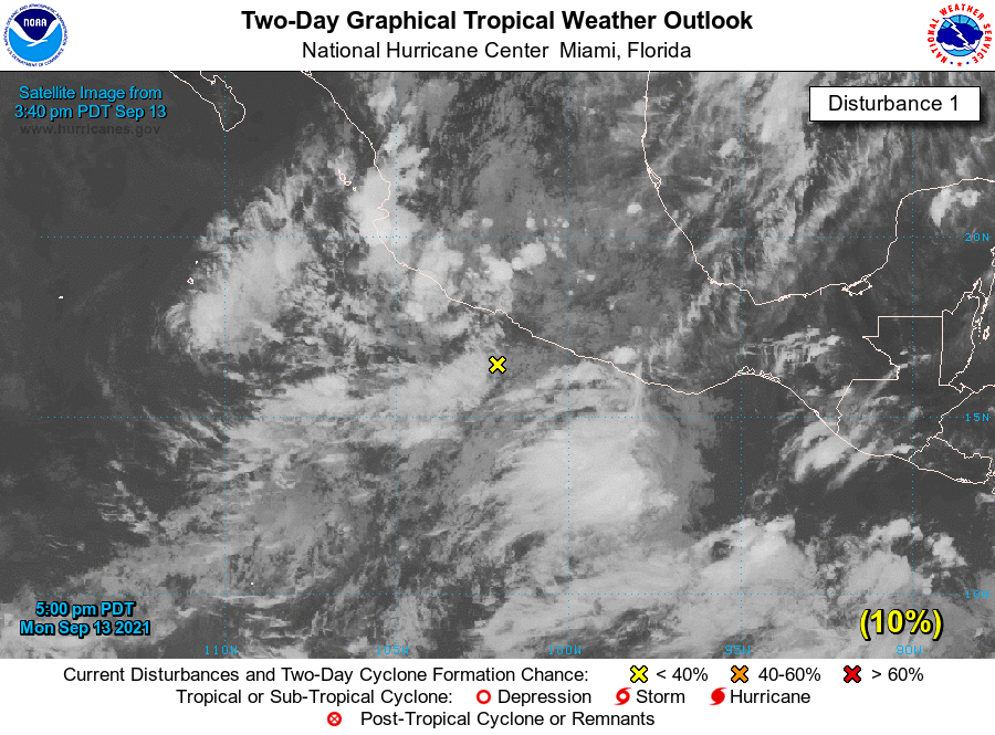
two_pac_2d1.png
回復

使用道具 舉報

簽到天數: 3206 天

[LV.Master]伴壇終老

king111807|2021-9-14 15:35 | 顯示全部樓層
NHC展望降至0%
1. An elongated trough of low pressure is located along the southern
and southwestern coasts of Mexico. Disorganized showers and
thunderstorms have been slowly diminishing, and environmental
conditions no longer appear conducive for additional development.
Regardless, this system will likely produce heavy rains across
portions of southern and southwestern Mexico through Tuesday.
* Formation chance through 48 hours...low...near 0 percent.
* Formation chance through 5 days...low...near 0 percent.
two_pac_2d1.png
回復

使用道具 舉報

快速回覆
您需要登錄後才可以回帖 登錄 | 立即加入

本版積分規則

本平台僅供學術討論之用,預報應以氣象局為準

威普網站虛擬主機贊助公司

臺灣第一個天氣類型社群平台 即時天氣資訊、精準颱風動態

線上客服
FB傳送訊息
廣告行銷
精準行銷 物超所值
官方粉專
發佈 快速回復 返回頂部 返回列表