開啟輔助訪問
 找回密碼
 立即加入

90L 一度發布TCFA 無緣升格

簽到天數: 2414 天

[LV.Master]伴壇終老

2021-7-23 20:49 | 顯示全部樓層
基本資料
編號    :90 L
擾動編號日期:2021 07 23 20
撤編日期  :2021 07 28 08
90L.INVEST.15kts.1000mb.30N.76W

20210723.1200.goes-16.vis.2km.90L.INVEST.15kts.1000mb.30N.76W.pc.jpg

   NHC:30%   
1. A trough of low pressure is located just offshore of the
southeastern United States coastline. Shower and thunderstorm
activity has increased this morning, and environmental conditions
appear marginally conducive for some additional development during
the next couple of days while the system drifts offshore of
the southeastern United States.
* Formation chance through 48 hours...low...30 percent.
* Formation chance through 5 days...low...30 percent.

two_atl_2d1.png

評分

參與人數 1水氣能量 +15 +1 收起 理由
t02436 + 15 + 1

查看全部評分

回復

使用道具 舉報

簽到天數: 1650 天

[LV.Master]伴壇終老

老農民版夜神月|2021-7-24 02:34 | 顯示全部樓層
NHC展望提升至Medium,40%
1. An area of low pressure located off of the southeastern United
States coastline continues to produce a large region of disorganized
showers and thunderstorms. Environmental conditions appear
marginally conducive for additional development and a tropical
depression could form over the next couple of days as the
system meanders over the Gulf Stream, just offshore of the
southeastern United States.
* Formation chance through 48 hours...medium...40 percent.
* Formation chance through 5 days...medium...40 percent.
two_atl_2d0 (12).png two_atl_2d1 (15).png
two_atl_5d1 (16).png 90L_gefs_latest.png
回復

使用道具 舉報

簽到天數: 3206 天

[LV.Master]伴壇終老

king111807|2021-7-25 03:24 | 顯示全部樓層
FWC-N發布TCFA
WTNT21 KNGU 241500
SUBJ/TROPICAL CYCLONE FORMATION ALERT (90L)//
RMKS/ 1. FORMATION OF A SIGNIFICANT TROPICAL CYCLONE IS POSSIBLE
WITHIN 100 NM EITHER SIDE OF A LINE FROM 29.2N 77.4W TO 27.8N 80.4W
WITHIN THE NEXT 24 HOURS. AVAILABLE DATA DOES NOT JUSTIFY ISSUANCE
OF NUMBERED TROPICAL CYCLONE WARNINGS AT THIS TIME. WINDS IN THE AREA
ARE ESTIMATED TO BE 20 TO 25 KNOTS. METSAT IMAGERY AT 241200Z INDICATES
THAT A CIRCULATION CENTER IS LOCATED NEAR 29.2N 77.4W. THE SYSTEM IS
MOVING WEST-SOUTHWESTWARD AT 06 KNOTS.
2. REMARKS: A LOW PRESSURE SYSTEM LOCATED A COUPLE HUNDRED MILES EAST
OF THE CENTRAL COAST OF FLORIDA IS PRODUCING AN AREA OF DISORGANIZED
SHOWERS AND THUNDERSTORMS WELL TO THE SOUTHEAST OF THE SURFACE CENTER.
ALTHOUGH SHOWER AND THUNDERSTORM ACTIVITY HAS CHANGED LITLE IN
ORGANIZATION SINCE YESTERDAY, THE CIRCULATION HAS GRADUALLY BECOME
BETTER DEFINED. UPPER-LEVEL WINDS ARE FORECAST TO BECOME A BIT MORE
FAVORABLE FOR DEVELOPMENT BY SUNDAY MORNING, AND A TROPICAL DEPRESSION
COULD FORM AS IT BEGINS DRIFTING GENERALLY WESTWARD TOWARD THE EAST
COAST OF FLORIDA LATER TODAY.
3. THIS ALERT WILL BE REISSUED, UPGRADED TO WARNING OR CANCELLED BY
251500Z.//
al902021.gif
回復

使用道具 舉報

簽到天數: 3206 天

[LV.Master]伴壇終老

king111807|2021-7-25 03:44 | 顯示全部樓層
NHC展望提升到60%
1. Showers and thunderstorm activity remain disorganized in association
with the low pressure system located about 200 miles east of Daytona
Beach, Florida. Environmental conditions appear only marginally
conducive for additional development, but a tropical depression
could still form over the next day or so while the low drifts
westward towards the Florida Peninsula. Interests in Florida should
continue to monitor the progress of this system.  An Air Force
Reserve Hurricane Hunter aircraft is en route to investigate the
system further.
* Formation chance through 48 hours...medium...60 percent.
* Formation chance through 5 days...medium...60 percent.
two_atl_2d1.png
回復

使用道具 舉報

簽到天數: 1650 天

[LV.Master]伴壇終老

老農民版夜神月|2021-7-25 09:08 | 顯示全部樓層
NHC展望略微降低至50%
1. Earlier this afternoon and evening, an Air Force Reserve Hurricane
Hunter aircraft investigated the low pressure system off the east
coast of Florida and found a well-defined center of circulation
about 185 miles east of Cape Canaveral.  However, the system still
lacks organized shower and thunderstorm activity near its center
and therefore has not met the criteria to be designated as a
tropical depression.  Environmental conditions are expected to
remain marginally conducive for additional development, and a
tropical depression could still form overnight or on Sunday while
the low moves generally westward at 5 to 10 mph toward the east
coast of Florida.  Interests in Florida should continue to monitor
the progress of this system.  Another Hurricane Hunter aircraft is
scheduled to investigate the system Sunday morning, if necessary.
* Formation chance through 48 hours...medium...50 percent.
* Formation chance through 5 days...medium...50 percent.
two_atl_2d0 (13).png two_atl_2d1 (16).png
two_atl_5d1 (17).png 90L_gefs_latest (1).png
回復

使用道具 舉報

簽到天數: 483 天

[LV.9]以壇為家II

dom|2021-7-26 13:31 | 顯示全部樓層
NHC展望降至Low
ZCZC MIATWOAT ALL
TTAA00 KNHC DDHHMM

Tropical Weather Outlook
NWS National Hurricane Center Miami FL
200 AM EDT Mon Jul 26 2021

For the North Atlantic...Caribbean Sea and the Gulf of Mexico:

1. Satellite and radar data indicate that shower and thunderstorm
activity associated with a low pressure system located about 45
miles east of St. Augustine, Florida, or about 75 miles southeast of
Jacksonville, Florida, remain disorganized and limited in coverage.  
Environmental conditions are gradually becoming less conducive for a
tropical depression to develop before the low moves inland over
northeastern Florida or Georgia later this morning.  However,
interests in these areas should continue to monitor the progress of
this system due to the possibility of brief periods of gusty winds
to 40 mph, locally heavy rainfall, and dangerous lightning strikes.
* Formation chance through 48 hours...low...30 percent.
* Formation chance through 5 days...low...30 percent.

Forecaster Stewart
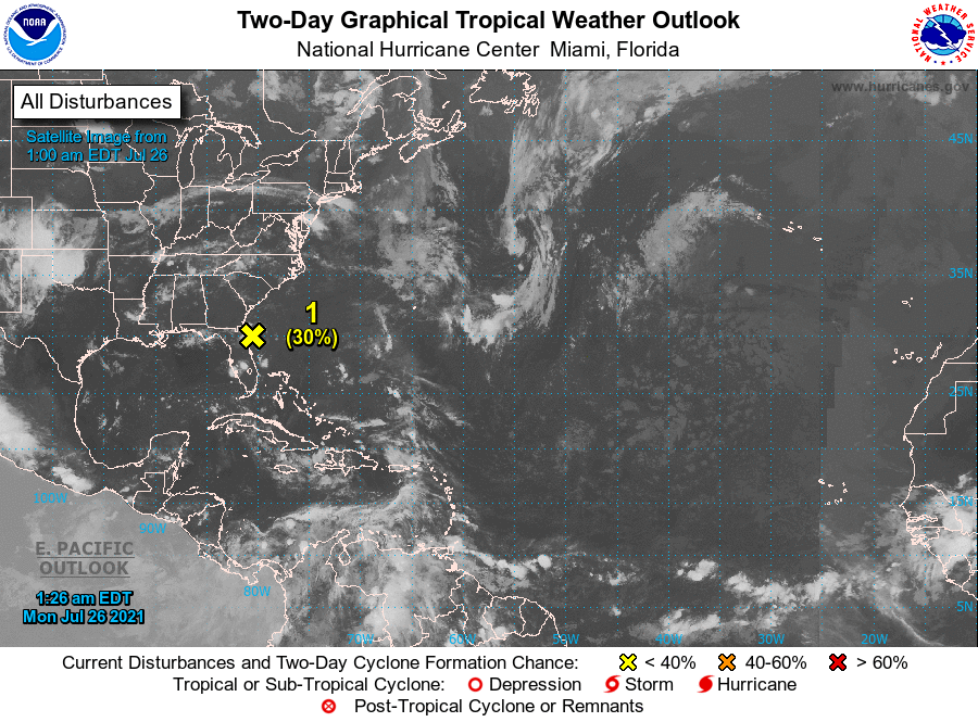
A2FDCFC8-9A8B-458E-B290-9104B0708401.png
回復

使用道具 舉報

簽到天數: 3206 天

[LV.Master]伴壇終老

king111807|2021-7-27 14:31 | 顯示全部樓層
NHC展望降至10%
1. A weak area of low pressure is located just inland along the
Georgia coastline. Shower and thunderstorm activity associated with
the low has increased somewhat tonight, but remains disorganized.
This system is expected to meander along the coastline of Georgia
and South Carolina over the next day or so, and a small chance of
development remains if the system moves back offshore over the
warm Gulf Stream waters. Locally heavy rainfall remains possible
over portions of the Georgia and South Carolina coast today.
* Formation chance through 48 hours...low...10 percent.
* Formation chance through 5 days...low...10 percent.
two_atl_2d1.png
回復

使用道具 舉報

簽到天數: 483 天

[LV.9]以壇為家II

dom|2021-7-27 22:48 | 顯示全部樓層
NHC新報不再認為其能有所發展
ZCZC MIATWOAT ALL
TTAA00 KNHC DDHHMM

Tropical Weather Outlook
NWS National Hurricane Center Miami FL
800 AM EDT Tue Jul 27 2021

For the North Atlantic...Caribbean Sea and the Gulf of Mexico:

1. The remnants of a weak low pressure area that moved inland along the
Georgia coastline last night are located just inland near the
Georgia/South Carolina border and are producing a few showers and
thunderstorms.  Significant redevelopment of this system is not
expected.
* Formation chance through 48 hours...low...near 0 percent.
* Formation chance through 5 days...low...near 0 percent.

Forecaster Pasch
9C20B38E-8E5A-438B-AE16-E48163E3AC99.png
回復

使用道具 舉報

快速回覆
您需要登錄後才可以回帖 登錄 | 立即加入

本版積分規則

本平台僅供學術討論之用,預報應以氣象局為準

威普網站虛擬主機贊助公司

臺灣第一個天氣類型社群平台 即時天氣資訊、精準颱風動態

線上客服
FB傳送訊息
廣告行銷
精準行銷 物超所值
官方粉專
發佈 快速回復 返回頂部 返回列表