開啟輔助訪問
 找回密碼
 立即加入

04E.Dolores 登陸墨西哥

簽到天數: 483 天

[LV.9]以壇為家II

2021-6-17 14:29 | 顯示全部樓層
  熱帶風暴  
編號:04 E
名稱:Dolores
003205jis3a4s94s1gagfe.jpg

  基本資料  
擾動編號日期:2021 06 17 14
命名日期  :2021 06 18 23
撤編日期  :2021 06 21 14
登陸地點  :墨西哥

  巔峰時期資料  
近中心最強風速 :35  kt ( TS )
海平面最低氣壓 :1004 百帕
  擾動編號資料  
94E.INVEST.20kts.1009mb.13.5N.99.0W

141724z0k6fllnqjhsyzkz.jpg

  NHC:70%  
1. A surface trough of low pressure is producing a large area of
disorganized showers and thunderstorms that extends several hundred
miles south of the coast of southern Mexico.  Environmental
conditions appear conducive for development of this disturbance, and
a tropical depression is likely to form late this week while the
system moves west-northwestward or northwestward at 5 to 10 mph,
near the coast of southwestern Mexico.  Regardless of development,
heavy rains are likely over coastal sections of the Mexican states
of Oaxaca, Guerrero, Michoacan, Colima, and Jalisco during the next
few days, which could cause life-threatening flash floods and mud
slides.  Interests in these areas should monitor the progress of
this system through the weekend.
* Formation chance through 48 hours...high...70 percent.
* Formation chance through 5 days...high...90 percent.

141844ym73m36mjzevxzx5.png
以上資料來自:NHC、颱風論壇整理製作

評分

參與人數 1水氣能量 +15 +1 收起 理由
king111807 + 15 + 1 熱帶擾動首帖

查看全部評分

回復

使用道具 舉報

簽到天數: 3291 天

[LV.Master]伴壇終老

t02436|2021-6-19 00:32 | 顯示全部樓層
命名Dolores
464
WTPZ44 KNHC 181449
TCDEP4

Tropical Storm Dolores Discussion Number   2
NWS National Hurricane Center Miami FL       EP042021
1000 AM CDT Fri Jun 18 2021

Recent SSMIS microwave imagery indicates that convective banding
continues to become established to the north and west of the
cyclone's center, while the overall area of deep convection is
gradually expanding.  Dvorak satellite classifications have
increased to T2.0/30 kt from TAFB and T2.3/35 kt from SAB, and the
depression is therefore being upgraded to a tropical storm with
maximum winds of 35 kt.

Dolores is moving toward the west-northwest (285/9 kt), to the south
of a weak mid-level ridge which extends from the northwestern
Caribbean Sea to central Mexico.  Since Dolores is now reaching the
western extent of this ridge, the storm is expected to turn
northwestward and then north-northwestward around the ridge later
today and into Saturday, reaching the coast of Colima or Jalisco by
Saturday evening.  The track models agree on this general scenario,
although there is some spread on exactly where and if the center
makes landfall.  The GFS and HWRF models show a sharper turn toward
the north, with the center moving inland near or south of the
Manzanillo area, while the ECMWF and UKMET models depict a wider
sweeping turn, keeping the center near or just off the coast in the
vicinity of Cabo Corrientes.  The updated NHC track forecast is
between these two scenarios, near the TVCE and HCCA consensus aids,
depicting a potential landfall along the Colima or Jalisco coasts
Saturday evening.  The new NHC track forecast is not too different
than the previous forecast, although it does show Dolores reaching
the coast a little sooner than previously expected.

Additional strengthening is anticipated up until Dolores's
potential landfall due to very warm sea surface temperatures (29 to
30 degrees Celsius), a moist environment, and significant
upper-level divergence.  The intensity models agree on this
strengthening, although since several of the track models already
have Dolores inland by 36 hours (which the NHC official forecast
does not), they're showing the cyclone's intensity too low at that
time.  The NHC intensity forecast is close to the HCCA consensus
aid through 24 hours, but then it is above all of the guidance at
36 hours in order to show at least some additional strengthening
before Dolores reaches the coast.  Based on this forecast, Dolores
is expected to be near or just below hurricane strength when it
reaches the coast.  This new forecast necessitates the
issuance of a tropical storm warning and a hurricane watch
for a portion of the west-central coast of Mexico.  Depending on
the amount of land interaction after 36 hours, Dolores is expected
to weaken fast as it continues moving northward along the
west-central coast of Mexico.

Key Messages:

1. Dolores is expected to continue strengthening today and on
Saturday, and it could be near hurricane strength when it reaches
the coast of west-central Mexico by Saturday evening.  A tropical
storm warning and a hurricane watch are now in effect for portions
of the southwestern and west-central coasts of Mexico.

2. Heavy rains are forecast over coastal sections of the Mexican
states of Oaxaca, Guerrero, Michoacan, Colima, Jalisco, and Nayarit
during the next few days, which could result in life-threatening
flash flooding and mudslides.


FORECAST POSITIONS AND MAX WINDS

INIT  18/1500Z 14.7N 102.5W   35 KT  40 MPH
12H  19/0000Z 15.3N 103.3W   45 KT  50 MPH
24H  19/1200Z 16.8N 104.3W   55 KT  65 MPH
36H  20/0000Z 19.2N 105.0W   60 KT  70 MPH
48H  20/1200Z 22.1N 105.6W   35 KT  40 MPH...INLAND
60H  21/0000Z 24.4N 106.2W   25 KT  30 MPH...POST-TROP/INLAND
72H  21/1200Z...DISSIPATED

$$
Forecaster Berg

145046_5day_cone_with_line.png

200101f4-a9be-4d8a-87af-1f22c8fed58e.jpg
回復

使用道具 舉報

簽到天數: 1650 天

[LV.Master]伴壇終老

老農民版夜神月|2021-6-19 05:31 | 顯示全部樓層
ASCAT16Z最新風場
20210618.1658.mtc.ASCAT.wind.04E.DOLORES.35kts-1004mb.145N.1022W.25km.noqc.jpeg 20210618.1605.mtb.ASCAT.wind.04E.DOLORES.35kts-1004mb.145N.1022W.25km.noqc.jpeg
20210618.1605.mtb.ASCAT.wind.04E.DOLORES.35kts-1004mb.145N.1022W.25km.jpeg
回復

使用道具 舉報

簽到天數: 1650 天

[LV.Master]伴壇終老

老農民版夜神月|2021-6-20 00:26 | 顯示全部樓層
NHC判定15Z時已位於墨西哥近岸,即將登陸,並定強TS上限60節
125
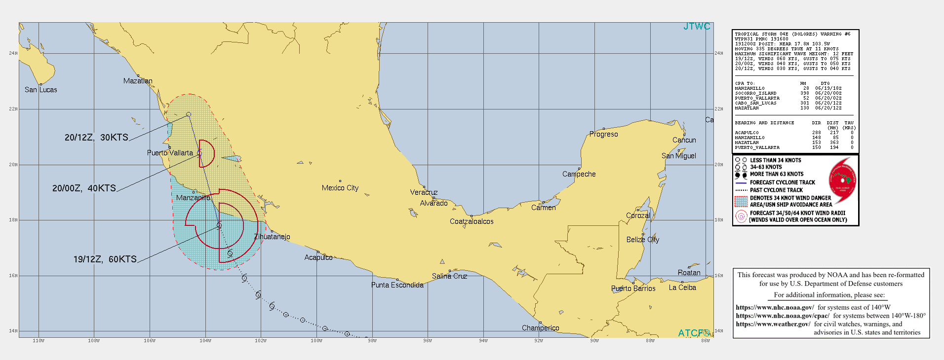
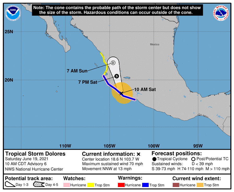
WTPZ44 KNHC 191437
TCDEP4

Tropical Storm Dolores Discussion Number   6
NWS National Hurricane Center Miami FL       EP042021
1000 AM CDT Sat Jun 19 2021

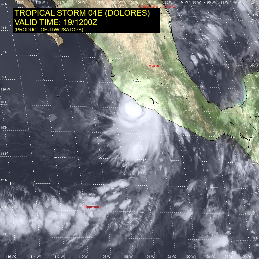
Satellite imagery indicates that Dolores's center is moving onshore
near the Michoacan/Colima border a little to the northwest of Punta
San Telmo, Mexico.  Within its last few hours over water, Dolores's
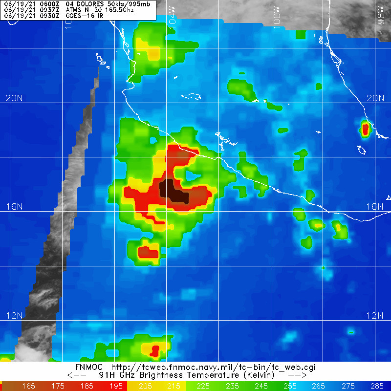
satellite presentation continued to improve, and an SSMIS microwave
pass from 1155 UTC showed that the storm has a large, well-defined
mid-level eye surrounded by a nearly closed eyewall.  Dolores
appears to be very close to hurricane strength, and its current
intensity is set at 60 kt as a compromise between estimates of T3.5
and T4.5 from TAFB and SAB, respectively.

Dolores has been accelerating while approaching the coast, and its
current motion is estimated to be toward the north-northwest (335
degrees) at 11 kt.  With the center forecast to move farther inland
through the day, the mountainous terrain of west-central Mexico is
expected to disrupt the surface circulation, and the model guidance
generally shows the low-level vorticity dissipating in about 12
hours, or less.  To maintain continuity with previous forecasts,
the NHC official forecast maintains a track for 24 hours, showing
Dolores weakening fast and degenerating to a remnant low over
west-central Mexico by this time tomorrow.  However, it is entirely
possible that the surface circulation will have dissipated by
Sunday morning, with the associated rains continuing to spread
northward with the remnant mid-level circulation.

Even though Dolores is making landfall, the hurricane watch for the
coast of Mexico is being maintained on this advisory since gusts to
hurricane force could be occurring to the east of where the center
is moving onshore.

Key Messages:

1. Even though Dolores had made landfall, tropical storm conditions
are still occurring within the tropical storm warning area and will
spread farther inland across west-central Mexico through the day
and tonight.  Hurricane conditions, especially in gusts, are still
possible for a few more hours within the hurricane watch area.

2. Heavy rains are forecast over coastal sections of the Mexican
states of Oaxaca, Guerrero, Michoacan, Colima, Jalisco, Nayarit,
and southern Sinaloa through the weekend, which could result in
life-threatening flash flooding and mudslides.


FORECAST POSITIONS AND MAX WINDS

INIT  19/1500Z 18.6N 103.7W   60 KT  70 MPH...ON THE COAST
12H  20/0000Z 20.4N 104.2W   40 KT  45 MPH...INLAND
24H  20/1200Z 21.8N 104.6W   30 KT  35 MPH...POST-TROP/INLAND
36H  21/0000Z...DISSIPATED

$$
Forecaster Berg
143753_5day_cone_no_line_and_wind.png ep0421 (1).gif
04E_191200sair.jpg 20210619.0937.n20.165bt.04E.DOLORES.50kts.995mb.16.6N.102.9W.015pc.jpg
回復

使用道具 舉報

簽到天數: 1650 天

[LV.Master]伴壇終老

老農民版夜神月|2021-6-20 05:47 | 顯示全部樓層
NHC判定其已登陸墨西哥
並預測其將於12H內深入內陸並快速減弱為後熱帶氣旋
000
WTPZ44 KNHC 192038
TCDEP4

Tropical Storm Dolores Discussion Number   7
NWS National Hurricane Center Miami FL       EP042021
400 PM CDT Sat Jun 19 2021

Dolores's circulation, and the associated weather, continue to move
farther inland over west-central Mexico, but it's hard to tell how
much of a surface circulation remains over the mountainous
topography of the region.  Deep convection continues to develop near
the estimated center, likely with the help of some orographic lift
of onshore flow.  Based on a typical decay rate over land, Dolores's
intensity is set at 45 kt, but there is higher-than-normal
uncertainty in this estimate given the effects of the terrain.

The heading remains toward the north-northwest (345 degrees), but
the speed has increased to 15 kt, likely due to the mid-level
circulation rotating around a mid-level low centered near Socorro
Island.  If the surface circulation has not yet been mangled by the
mountainous terrain, it will soon, and the mid-level circulation
should then continue north-northwestward through tonight.  The
new NHC forecast shows continued rapid weakening and depicts
Dolores as a remnant low in 12 hours, but in reality the
circulation may have dissipated by that time.  This forecast
reasoning follows the quick dissipation of vorticity indicated in
the global model fields.

Even though Dolores is moving farther inland, the coastal watches
and warnings are being maintained on this advisory until there is
no longer a threat of tropical-storm-force winds in those areas.


Key Messages:

1. Tropical storm conditions are still occurring within the
tropical storm warning area and will spread farther inland across
west-central Mexico through tonight.

2. Heavy rains are forecast over coastal sections of the Mexican
states of Guerrero, Michoacan, Colima, Jalisco, Nayarit, and
southern Sinaloa through the weekend, which could result in
life-threatening flash flooding and mudslides.


FORECAST POSITIONS AND MAX WINDS

INIT  19/2100Z 20.3N 104.1W   45 KT  50 MPH...INLAND
12H  20/0600Z 22.5N 104.5W   25 KT  30 MPH...POST-TROP/INLAND
24H  20/1800Z...DISSIPATED

$$
Forecaster Berg

204016_5day_cone_no_line_and_wind.png ep0421 (2).gif

04E_191800sair.jpg GOES21062021170jpFePM.jpg
回復

使用道具 舉報

簽到天數: 1650 天

[LV.Master]伴壇終老

老農民版夜神月|2021-6-20 10:51 | 顯示全部樓層
本帖最後由 老農民版夜神月 於 2021-6-20 11:17 編輯

NHC降格TD
763
WTPZ44 KNHC 200239
TCDEP4

Tropical Depression Dolores Discussion Number   8
NWS National Hurricane Center Miami FL       EP042021
1000 PM CDT Sat Jun 19 2021

Satellite imagery and surface observations indicate that Tropical
Depression Dolores continues to rapidly weaken. It is getting very
difficult to locate a low-level center at this time, if one still
exists over the mountainous terrain. Given the length of time
already spent over this terrain, the estimated initial intensity is
being lowered to 25 kt for this advisory.

Dolores is moving north at 18 kt between a ridge to its east and a
mid-level low to its west. This motion is expected to continue
through tonight, keeping Dolores well inland over western Mexico.
This track over the rugged terrain should cause Dolores to finally
dissipate late tonight or on Sunday morning.

Although Dolores may dissipate soon, the abundant moisture
associated with the system is expected to continue to produce heavy
rainfall over portions of southwestern and west-central Mexico for
the remainder of the weekend.


Key Messages:

1. Wind gusts to near tropical storm force will likely continue over
coastal sections of west-central Mexico to the south of Puerto
Vallarta through early tonight.

2. Heavy rains are forecast over coastal sections of the Mexican
states of Guerrero, Michoacan, Colima, Jalisco, Nayarit, and
southern Sinaloa through Sunday, which could result in
life-threatening flash flooding and mudslides.


FORECAST POSITIONS AND MAX WINDS

INIT  20/0300Z 22.3N 104.3W   25 KT  30 MPH
12H  20/1200Z...DISSIPATED

$$
Forecaster Latto

024025_5day_cone_no_line_and_wind.png ep0421.gif 04E_200000sair.jpg
回復

使用道具 舉報

簽到天數: 1650 天

[LV.Master]伴壇終老

老農民版夜神月|2021-6-20 16:43 | 顯示全部樓層
本帖最後由 老農民版夜神月 於 2021-6-20 21:22 編輯

NHC判定已成為殘餘低氣壓,並發布最終報
WTPZ44 KNHC 200834
TCDEP4

Remnants Of Dolores Discussion Number   9
NWS National Hurricane Center Miami FL       EP042021
400 AM CDT Sun Jun 20 2021

Satellite imagery and limited surface observations indicate that
Dolores has dissipated over the mountainous terrain of central
Mexico.  Although a mid-level circulation is evident in satellite
imagery, this structure no longer extends down to the surface.
Therefore, this will be the last NHC advisory on this system.

Although the system has dissipated, the remnants of Dolores remain
capable of producing heavy rainfall over portions of southwestern
and west-central Mexico today, which could produce life-threatening
flash flooding and mudslides. For more information, see products
issued by your national meteorological service.


Key Messages:

1. Heavy rains are forecast over coastal sections of the Mexican
states of Guerrero, Michoacan, Colima, Jalisco, Nayarit, and
southern Sinaloa through today, which could result in
life-threatening flash flooding and mudslides.


FORECAST POSITIONS AND MAX WINDS

INIT  20/0900Z 23.5N 103.7W   20 KT  25 MPH
12H  20/1800Z...DISSIPATED

$$
Forecaster Reinhart/Blake

083523_5day_cone_no_line_and_wind.png ep0421 (3).gif 04E_200600sair.jpg
回復

使用道具 舉報

快速回覆
您需要登錄後才可以回帖 登錄 | 立即加入

本版積分規則

dom

    主題

    帖子

    24萬

    積分

    11級[狂風Violent storm]

    Rank: 11Rank: 11Rank: 11Rank: 11

11級[狂風Violent storm]

發訊息

本平台僅供學術討論之用,預報應以氣象局為準

威普網站虛擬主機贊助公司

臺灣第一個天氣類型社群平台 即時天氣資訊、精準颱風動態

線上客服
FB傳送訊息
廣告行銷
精準行銷 物超所值
官方粉專
發佈 快速回復 返回頂部 返回列表