開啟輔助訪問
 找回密碼
 立即加入

01E.Andres 東太史上最早TS

簽到天數: 1650 天

[LV.Master]伴壇終老

老農民版夜神月|2021-5-9 14:46 | 顯示全部樓層
ASCAT最新風場,已掃出部分30甚至35KT左右的風旗 LATEST - 2021-05-09T144542.609.jpg LATEST - 2021-05-09T144527.685.jpg
20210509.0620.goes-17.ir.90E.INVEST.25kts.1007mb.13.3N.106.9W.100pc.jpg
回復

使用道具 舉報

簽到天數: 483 天

[LV.9]以壇為家II

dom|2021-5-9 16:27 | 顯示全部樓層
本帖最後由 dom 於 2021-5-9 16:54 編輯

NHC升格TD01E,上望35節
若此系統獲名便會打破東太史上最早命名記錄
829
WTPZ21 KNHC 090832
TCMEP1

TROPICAL DEPRESSION ONE-E FORECAST/ADVISORY NUMBER   1
NWS NATIONAL HURRICANE CENTER MIAMI FL       EP012021
0900 UTC SUN MAY 09 2021

THERE ARE NO COASTAL WATCHES OR WARNINGS IN EFFECT.

TROPICAL DEPRESSION CENTER LOCATED NEAR 13.8N 107.7W AT 09/0900Z
POSITION ACCURATE WITHIN  25 NM

PRESENT MOVEMENT TOWARD THE NORTHWEST OR 325 DEGREES AT   4 KT

ESTIMATED MINIMUM CENTRAL PRESSURE 1006 MB
MAX SUSTAINED WINDS  30 KT WITH GUSTS TO  40 KT.
WINDS AND SEAS VARY GREATLY IN EACH QUADRANT.  RADII IN NAUTICAL
MILES ARE THE LARGEST RADII EXPECTED ANYWHERE IN THAT QUADRANT.

REPEAT...CENTER LOCATED NEAR 13.8N 107.7W AT 09/0900Z
AT 09/0600Z CENTER WAS LOCATED NEAR 13.6N 107.6W

FORECAST VALID 09/1800Z 14.5N 108.1W
MAX WIND  35 KT...GUSTS  45 KT.
34 KT... 60NE   0SE   0SW   0NW.

FORECAST VALID 10/0600Z 15.3N 108.6W
MAX WIND  35 KT...GUSTS  45 KT.
34 KT... 60NE   0SE   0SW   0NW.

FORECAST VALID 10/1800Z 15.8N 109.2W
MAX WIND  30 KT...GUSTS  40 KT.

FORECAST VALID 11/0600Z 16.1N 110.0W...POST-TROP/REMNT LOW
MAX WIND  25 KT...GUSTS  35 KT.

FORECAST VALID 11/1800Z 16.2N 110.9W...POST-TROP/REMNT LOW
MAX WIND  25 KT...GUSTS  35 KT.

FORECAST VALID 12/0600Z 16.2N 112.2W...POST-TROP/REMNT LOW
MAX WIND  20 KT...GUSTS  30 KT.

EXTENDED OUTLOOK. NOTE...ERRORS FOR TRACK HAVE AVERAGED NEAR 100 NM
ON DAY 4 AND 125 NM ON DAY 5...AND FOR INTENSITY NEAR 15 KT EACH DAY

OUTLOOK VALID 13/0600Z 15.8N 115.0W...POST-TROP/REMNT LOW
MAX WIND  20 KT...GUSTS  30 KT.

OUTLOOK VALID 14/0600Z...DISSIPATED

REQUEST FOR 3 HOURLY SHIP REPORTS WITHIN 300 MILES OF 13.8N 107.7W

NEXT ADVISORY AT 09/1500Z

$$
FORECASTER STEWART
004210hrc5waksvcacexl5.png 0.png
回復

使用道具 舉報

簽到天數: 3291 天

[LV.Master]伴壇終老

t02436|2021-5-10 00:06 | 顯示全部樓層
15Z命名,打破2017紀錄,成為東太史上最早TS。
000
WTPZ41 KNHC 091454
TCDEP1

Tropical Storm Andres Discussion Number   2
NWS National Hurricane Center Miami FL       EP012021
900 AM MDT Sun May 09 2021

Although the system lacks well-defined convective banding features,
Dvorak intensity estimates from both TAFB and SAB are 35 kt.
This is consistent with a data T-number based on a shear pattern
with the low-level center displaced within 3/4 degrees to the west
of the edge of the main area of deep convection, as suggested by
recent microwave imagery.  Since earlier scatterometer data
indicated that the system was close to tropical storm strength,
and given the latest Dvorak analyses, the cyclone is being named.  
Andres is the earliest tropical storm on record in the eastern
North Pacific basin, just beating out Adrian of 2017.  

Increasing southwesterly to westerly shear and drier air to the
west of the cyclone should prevent any significant additional
strengthening.  The official forecast generally follows the
numerical guidance and shows the system degenerating into a remnant
low in 48 hours, as in the previous advisory.

The initial motion is slowly northwestward, or 325/5.  Andres
should move along the southwestern side of a low- to mid-level
ridge for the next couple of days and turn westward in the
low-level flow as an increasingly shallow circulation.  The
official track forecast is on the southern side of the model
guidance suite.  This also close to the latest latest corrected
consensus, or HCCA, track.


FORECAST POSITIONS AND MAX WINDS

INIT  09/1500Z 14.1N 107.9W   35 KT  40 MPH
12H  10/0000Z 14.8N 108.4W   35 KT  40 MPH
24H  10/1200Z 15.4N 108.9W   35 KT  40 MPH
36H  11/0000Z 15.9N 109.5W   30 KT  35 MPH
48H  11/1200Z 16.2N 110.2W   25 KT  30 MPH...POST-TROP/REMNT LOW
60H  12/0000Z 16.5N 111.2W   25 KT  30 MPH...POST-TROP/REMNT LOW
72H  12/1200Z 16.4N 112.5W   20 KT  25 MPH...POST-TROP/REMNT LOW
96H  13/1200Z 16.3N 115.2W   20 KT  25 MPH...POST-TROP/REMNT LOW
120H  14/1200Z...DISSIPATED

$$
Forecaster Pasch

145513_5day_cone_with_line.png

GOES1550202112958BBAc.jpg

評分

參與人數 1水氣能量 +10 收起 理由
dom + 10 打破舊紀錄

查看全部評分

回復

使用道具 舉報

簽到天數: 1650 天

[LV.Master]伴壇終老

老農民版夜神月|2021-5-10 06:28 | 顯示全部樓層
本帖最後由 老農民版夜神月 於 2021-5-10 06:35 編輯

SSD18Z分析T2.5
TXPZ27 KNES 091734
TCSENP

A.  01E (ANDRES)

B.  09/1730Z

C.  13.9N

D.  108.5W

E.  THREE/GOES-W

F.  T2.5/2.5

G.  IR/EIR/VIS/GMI/SSMIS

H.  REMARKS...LOOSELY DEFINED CLOUD LINES SURROUND A LLCC THAT IS <
1.25 DEGREES FROM A LARGE COLD OVERCAST. THIS YIELDS A DT OF 1.5 VIA
THE SHEAR PATTERN. MET AND PT ARE 2.5 AND FT IS BASED ON MET DUE TO
UNCERTAINTY OF THE EXACT LOCATION OF THE LLCC.

I.  ADDL POSITIONS

    09/1130Z 14.0N 107.9W GMI
    09/1350Z 14.0N 108.2W SSMIS


...MLEVINE

20210509.2200.goes-17.ir.01E.ANDRES.35kts.1005mb.13.9N.108.4W.100pc.jpg 20210509.1520.goes-16.irbd.01E.ANDRES.35kts.1005mb.13.9N.107.8W.100pc.jpg
回復

使用道具 舉報

簽到天數: 1650 天

[LV.Master]伴壇終老

老農民版夜神月|2021-5-10 06:36 | 顯示全部樓層
晚間半夜時分最新風場
LATEST - 2021-05-10T062150.927.jpg 20210509.1517.mta.ASCAT.wind.01E.ANDRES.35kts-1005mb.139N.1078W.25km.noqc.jpeg
20210509.1517.mta.ASCAT.wind.01E.ANDRES.35kts-1005mb.140N.1084W.25km.noqc.jpeg
回復

使用道具 舉報

簽到天數: 1650 天

[LV.Master]伴壇終老

老農民版夜神月|2021-5-11 04:52 | 顯示全部樓層
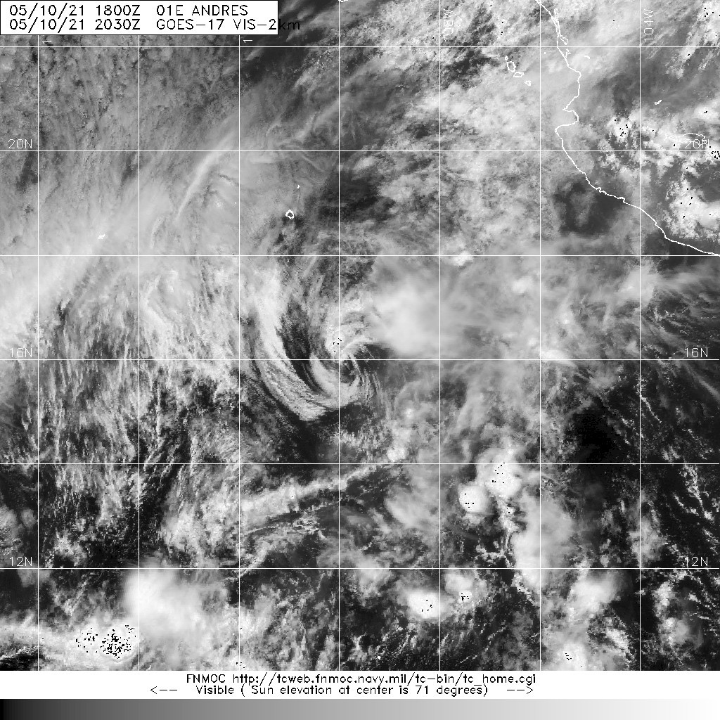
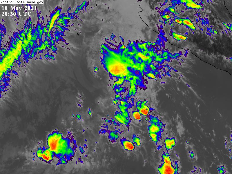
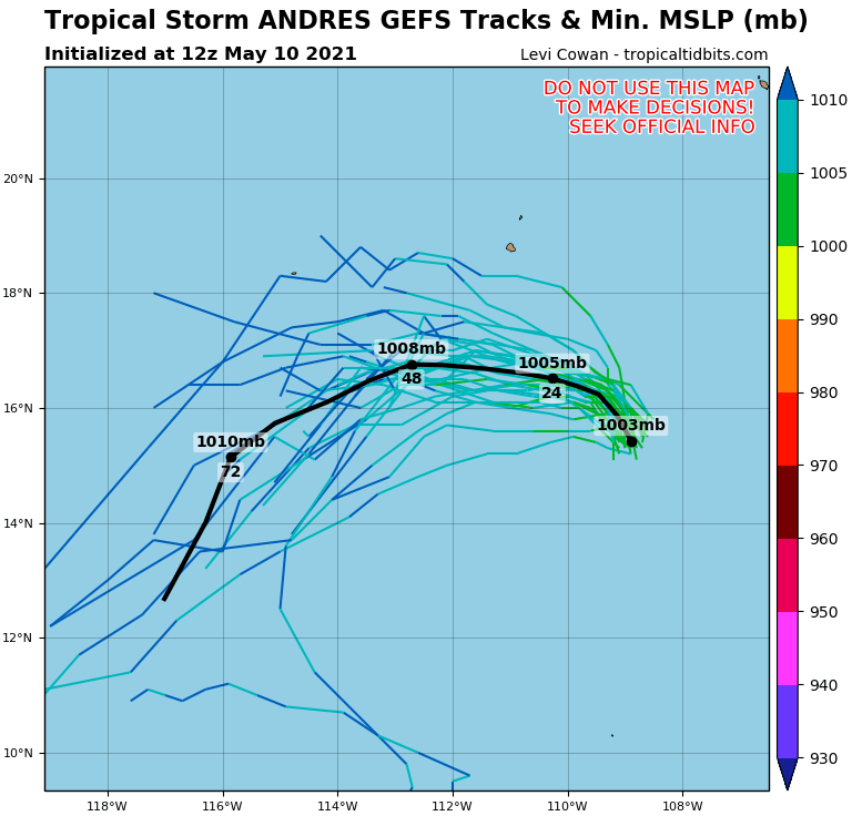
NHC21Z降TD,並預測24H內將成為殘餘低氣壓
000
WTPZ41 KNHC 102036
TCDEP1

Tropical Depression Andres Discussion Number   7
NWS National Hurricane Center Miami FL       EP012021
300 PM MDT Mon May 10 2021

Hostile environmental conditions are taking a toll on Andres this
afternoon. After a small area of convection persisted downshear of
the cyclone's partially exposed low-level center earlier today,
recent satellite images show rapidly warming cloud tops in the
northeast quadrant with no signs of new convection anywhere near the
center. Additionally, the low-level center now appears to be
completely exposed. Although T2.5 18Z Dvorak classifications were
received from SAB and TAFB, recent satellite trends and UW-CIMSS ADT
estimates indicate the system has weakened since that time.
Therefore, the intensity is lowered to 30 kt with this advisory,
making Andres a tropical depression.

Andres appeared to take a bit of a northward jog earlier today, but
the current estimated motion is 330/06 kt. The weakening, shallow
cyclone is expected to turn more west-northwestward and westward on
Tuesday and Wednesday under the influence of a building low-level
ridge to its north. The latest track forecast is close to the center
of the guidance envelope, with just a slight adjustment to the right
of track from the previous forecast.

An upper-level ridge to the northwest of the cyclone is producing
increasing vertical wind shear over Andres. This, combined with some
drier mid-level air encroaching on the cyclone from the west, will
continue weakening Andres through its dissipation by midweek.
Simulated satellite imagery from the GFS and ECMWF suggest the
system will struggle to generate any new convection overnight, and
this forecast shows Andres becoming a remnant low on Tuesday.


FORECAST POSITIONS AND MAX WINDS

INIT  10/2100Z 16.0N 109.8W   30 KT  35 MPH
12H  11/0600Z 16.5N 110.2W   30 KT  35 MPH
24H  11/1800Z 16.8N 111.1W   25 KT  30 MPH...POST-TROP/REMNT LOW
36H  12/0600Z 17.0N 112.2W   20 KT  25 MPH...POST-TROP/REMNT LOW
48H  12/1800Z 16.9N 113.5W   20 KT  25 MPH...POST-TROP/REMNT LOW
60H  13/0600Z...DISSIPATED

$$
Forecaster Reinhart/Cangialosi
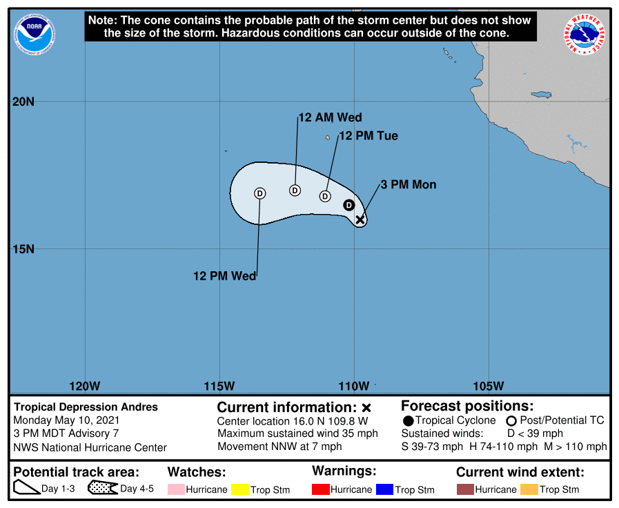
203610_5day_cone_no_line_and_wind.png 20210510.2030.goes-17.vis.2km.01E.ANDRES.35kts.1005mb.16N.109.6W.pc.jpg
GOES20302021130TueQBR.jpg 01E_gefs_latest.png
回復

使用道具 舉報

簽到天數: 1650 天

[LV.Master]伴壇終老

老農民版夜神月|2021-5-12 00:40 | 顯示全部樓層
NHC於15Z報判定已成為後熱帶氣旋
000
WTPZ41 KNHC 111438
TCDEP1

Post-Tropical Cyclone Andres Discussion Number  10
NWS National Hurricane Center Miami FL       EP012021
900 AM MDT Tue May 11 2021

Hostile environmental conditions have reduced Andres to an exposed,
low-level cloud swirl. Although a small burst of convection was
noted earlier this morning over 100 n mi northeast of the center,
Andres has been without organized deep convection near its center
for over 12 hours. Therefore, the cyclone has become a remnant low,
and this will be the final NHC advisory on Andres.

The remnant low is moving just south of due west and will continue
moving westward within the low-level trade wind flow until it
dissipates on Wednesday night. Overnight scatterometer data
indicated that 20-25 kt winds were confined to the northwest
quadrant of Andres, between the cyclone and a subtropical ridge to
its northwest. Continued weakening is expected as the remnant low
moves into a drier, more stable environment with increasing wind
shear and decreasing sea-surface temperatures.

This is the last NHC advisory on Andres. For additional information
on the remnant low please see High Seas Forecasts issued by the
National Weather Service, under AWIPS header NFDHSFEPI, WMO header
FZPN02 KWBC, and on the web at ocean.weather.gov/shtml/NFDHSFEPI.php


FORECAST POSITIONS AND MAX WINDS

INIT  11/1500Z 15.8N 111.4W   25 KT  30 MPH...POST-TROPICAL
12H  12/0000Z 15.8N 112.3W   20 KT  25 MPH...POST-TROP/REMNT LOW
24H  12/1200Z 15.7N 113.5W   20 KT  25 MPH...POST-TROP/REMNT LOW
36H  13/0000Z...DISSIPATED

$$
Forecaster Reinhart/Brown
143725_5day_cone_no_line_and_wind.png 20210511.1610.goes-17.vis.2km.01E.ANDRES.25kts.1007mb.15.9N.111.1W.pc.jpg
GOES162020211317bZhxG.jpg
回復

使用道具 舉報

12
快速回覆
您需要登錄後才可以回帖 登錄 | 立即加入

本版積分規則

本平台僅供學術討論之用,預報應以氣象局為準

威普網站虛擬主機贊助公司

臺灣第一個天氣類型社群平台 即時天氣資訊、精準颱風動態

線上客服
FB傳送訊息
廣告行銷
精準行銷 物超所值
官方粉專
發佈 快速回復 返回頂部 返回列表