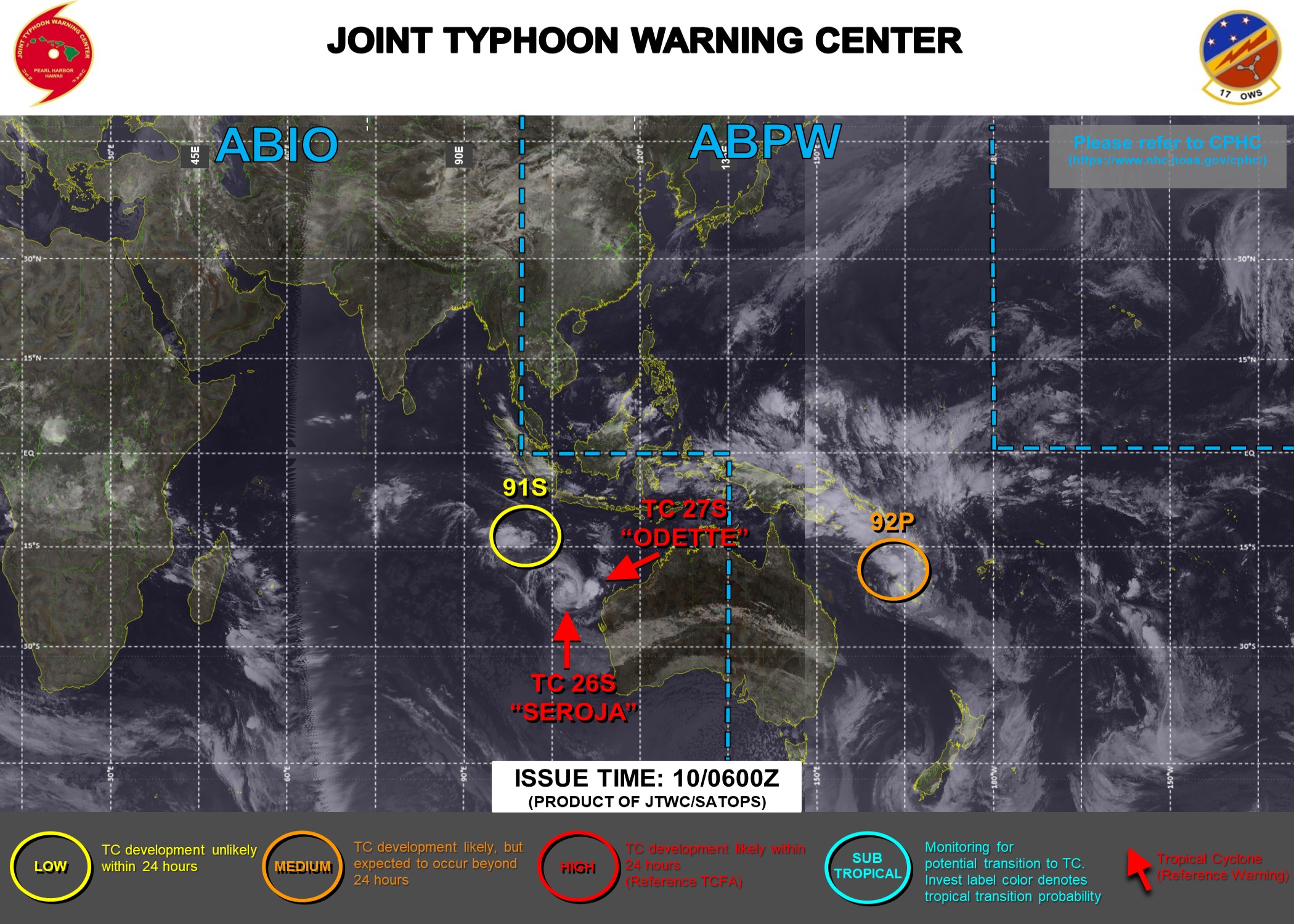
開啟輔助訪問
 找回密碼
 立即加入

27S.Odette 遭26S併吞

簽到天數: 1650 天

[LV.Master]伴壇終老

老農民版夜神月|2021-4-9 11:35 | 顯示全部樓層
JTWC,BoM均認為其已達巔峰 sh2721 (7).gif 27S_090000sair.jpg
IDW27700
TROPICAL CYCLONE TECHNICAL BULLETIN: AUSTRALIA - WESTERN REGION
Issued by AUSTRALIAN BUREAU OF METEOROLOGY TROPICAL CYCLONE WARNING CENTRE
at: 0116 UTC 09/04/2021
Name: Tropical Cyclone Odette
Identifier: 23U
Data At: 0000 UTC
Latitude: 14.2S
Longitude: 107.7E
Location Accuracy: within 20 nm [35 km]
Movement Towards: east northeast [068 deg]
Speed of Movement: 11 knots [20 km/h]
Maximum 10-Minute Wind: 45 knots [85 km/h]
Maximum 3-Second Wind Gust: 65 knots [120 km/h]
Central Pressure: 990 hPa
Radius of 34-knot winds NE quadrant: 70 nm [130 km]
Radius of 34-knot winds SE quadrant:   
Radius of 34-knot winds SW quadrant: 70 nm [130 km]
Radius of 34-knot winds NW quadrant: 80 nm [150 km]
Radius of 48-knot winds NE quadrant:   
Radius of 48-knot winds SE quadrant:   
Radius of 48-knot winds SW quadrant:   
Radius of 48-knot winds NW quadrant:   
Radius of 64-knot winds:
Radius of Maximum Winds: 30 nm [55 km]
Dvorak Intensity Code: T3.0/3.0/D0.5/24HRS STT:S0.0/06HRS
Pressure of outermost isobar: 1000 hPa
Radius of outermost closed isobar: 90 nm [165 km]
FORECAST DATA
Date/Time    : Location    : Loc. Accuracy: Max Wind   : Central Pressure
[UTC]        : degrees     :      nm  [km]: knots[km/h]: hPa
+06:  09/0600: 14.7S 109.2E:     040 [075]:  045  [085]:  988
+12:  09/1200: 15.7S 110.7E:     055 [100]:  045  [085]:  989
+18:  09/1800: 17.1S 111.9E:     070 [130]:  045  [085]:  989
+24:  10/0000: 18.7S 112.4E:     090 [165]:  040  [075]:  991
+36:  10/1200: 22.3S 111.1E:     110 [205]:  040  [075]:  990
+48:  11/0000: 25.1S 109.9E:     120 [220]:  035  [065]:  991
+60:  11/1200:             :              :            :     
+72:  12/0000:             :              :            :     
+96:  13/0000:             :              :            :     
+120: 14/0000:             :              :            :     
REMARKS:
Tropical Cyclone Odette location was based on animated infrared and past
microwave imagery around 2100UTC. Confidence in the position is good. There has
been increasing confidence of an increase in intensity with the main convective
mass now located over the low level centre, and with banding also evident in
microwave imagery.

Dvorak analysis gives a DT 3.0 from both a curved band and shear pattern. MET is
3.5 adjusted to a PAT of 3.0, FT and CI are also 3.0. CIMSS ADT CI is 3.2 and
NOAA ADT has a CI of 3.3. SATCON was 54 knots [1-minute] at 1812UTC. Final
intensity set to 45 knots [10-minute].

Steering of Tropical Cyclone Odette has been to the east-northeast overnight and
early this morning. This is being significantly impacted by interaction with
Tropical Cyclone Seroja. There is good model consensus that steering over the
remainder of Friday will be to the east and southeast, prior to turning south to
south-southwest during Saturday.

Shear remains moderate to high with good poleward outflow and warm sea surface
temperatures [29-30C]. As TC Odette and TC Seroja continue to interact, Odette
should begin weakening during Saturday as Seroja dominates. An impact to the far
northwest corner of WA coast around Exmouth is possible on Saturday with a short
period of strong to gale force winds and rain even though the system should no
longer be a TC.


Copyright Commonwealth of Australia
==
The next bulletin for this system will be issued by: 09/0730 UTC.
LATEST - 2021-04-09T112855.818.jpg LATEST - 2021-04-09T112849.091.jpg
回復

使用道具 舉報

簽到天數: 1650 天

[LV.Master]伴壇終老

老農民版夜神月|2021-4-10 04:12 | 顯示全部樓層
本帖最後由 老農民版夜神月 於 2021-4-10 04:24 編輯

BoM認為其即將遭到26S徹底併吞,+12H後便已不是澳式C1
IDW60284 (4).png
Time (AWST)Intensity CategoryLatitude
(decimal deg.)
Longitude
(decimal deg.)
Estimated Position
Accuracy (km)
0hr2 am April 10117.1S112.1E30
+6hr8 am April 10119.0S112.4E65
+12hr2 pm April 10tropical low21.2S111.9E110
+18hr8 pm April 10tropical low23.2S110.6E160
+24hr2 am April 11tropical low24.7S109.3E165
+36hr2 pm April 11tropical lowXXXXXXXXX
+48hr2 am April 12tropical lowXXXXXXXXX
+60hr2 pm April 12tropical lowXXXXXXXXX
+72hr2 am April 13tropical lowXXXXXXXXX
IDW27700
TROPICAL CYCLONE TECHNICAL BULLETIN: AUSTRALIA - WESTERN REGION
Issued by AUSTRALIAN BUREAU OF METEOROLOGY TROPICAL CYCLONE WARNING CENTRE
at: 1930 UTC 09/04/2021
Name: Tropical Cyclone Odette
Identifier: 23U
Data At: 1800 UTC
Latitude: 17.1S
Longitude: 112.1E
Location Accuracy: within 15 nm [30 km]
Movement Towards: southeast [138 deg]
Speed of Movement: 17 knots [32 km/h]
Maximum 10-Minute Wind: 40 knots [75 km/h]
Maximum 3-Second Wind Gust: 55 knots [100 km/h]
Central Pressure: 994 hPa
Radius of 34-knot winds NE quadrant: 70 nm [130 km]
Radius of 34-knot winds SE quadrant: 50 nm [95 km]
Radius of 34-knot winds SW quadrant:   
Radius of 34-knot winds NW quadrant: 70 nm [130 km]
Radius of 48-knot winds NE quadrant:   
Radius of 48-knot winds SE quadrant:   
Radius of 48-knot winds SW quadrant:   
Radius of 48-knot winds NW quadrant:   
Radius of 64-knot winds:
Radius of Maximum Winds: 25 nm [45 km]
Dvorak Intensity Code: T2.5/2.5/W0.5/24HRS STT: D0.5/06HRS
Pressure of outermost isobar: 1002 hPa
Radius of outermost closed isobar: 70 nm [130 km]
FORECAST DATA
Date/Time    : Location    : Loc. Accuracy: Max Wind   : Central Pressure
[UTC]        : degrees     :      nm  [km]: knots[km/h]: hPa
+06:  10/0000: 19.0S 112.4E:     035 [065]:  040  [075]:  994
+12:  10/0600: 21.2S 111.9E:     060 [110]:  040  [075]:  993
+18:  10/1200: 23.2S 110.6E:     085 [160]:  035  [065]:  996
+24:  10/1800: 24.7S 109.3E:     090 [165]:  030  [055]:  997
+36:  11/0600:             :              :            :     
+48:  11/1800:             :              :            :     
+60:  12/0600:             :              :            :     
+72:  12/1800:             :              :            :     
+96:  13/1800:             :              :            :     
+120: 14/1800:             :              :            :     
REMARKS:
Tropical Cyclone Odette has weakened due the shear and has an exposed low level
centre. The location was based on animated IR satellite imagery with good
confidence in the position.

Dvorak analysis gives a DT 2.5 averaged over the last 3 hours from a shear
pattern with latest imagery showing flaring convection less than 0.5 degrees
from the centre location MET/PAT is 2.0 based on a 24h W trend. FT based on the
DT and CI is raised to 2.5. Raw ADT T numbers are 2.7 to 2.8. SATCON at 1417Z
was 51kt [1 min mean]. Intensity set at 40 knots.

Steering of Tropical Cyclone Odette has been rapid to the southeast over the
last 12 hours. This is being significantly impacted by interaction with Tropical
Cyclone Seroja. There is good model consensus that steering will to turn to the
south Saturday morning  and then to the south-southwest later on Saturday.

Shear has been unfavourable over Odette, with CIMSS estimates of 30 to 35 knots,
although recent shear estimates have reduced to about 20 knots. Model guidance
indicates that shear over Odette will remain unfavourable and it will be
unlikely for the system to intensify again. This will lead to Odette weakening
below tropical cyclone strength Saturday morning.

In regards to coastal and community impacts, the far northwest corner of WA
between Exmouth and Coral Bay remain a slight risk of experiencing a brief
period of damaging wind gusts during the afternoon and evening of Saturday as
Tropical Cyclone Odette moves to the south, offshore from the west Pilbara.
Significant rainfall that could lead to flash flooding or riverine flooding is
not expected.


Copyright Commonwealth of Australia
==
The next bulletin for this system will be issued by: 10/0130 UTC.

20210409.1940.himawari-8.ir.27S.ODETTE.40kts.993mb.17S.112.3E.100pc.jpg 20210409.1744.gw1.89hbt.27S.ODETTE.40kts.993mb.17S.112.3E.90pc.jpg 20210409.1744.gw1.89pct89h89v.27S.ODETTE.40kts.993mb.17S.112.3E.90pc.jpg
回復

使用道具 舉報

簽到天數: 1650 天

[LV.Master]伴壇終老

老農民版夜神月|2021-4-10 05:34 | 顯示全部樓層
JTWC亦預測+24H內將被26S完全吸收,不出意外的話03Z或09Z便會發布Final Warning
WTXS32 PGTW 092100
MSGID/GENADMIN/JOINT TYPHOON WRNCEN PEARL HARBOR HI//
SUBJ/TROPICAL CYCLONE 27S (ODETTE) WARNING NR 020//
RMKS/
1. TROPICAL CYCLONE 27S (ODETTE) WARNING NR 020   
   02 ACTIVE TROPICAL CYCLONES IN SOUTHIO
   MAX SUSTAINED WINDS BASED ON ONE-MINUTE AVERAGE
   WIND RADII VALID OVER OPEN WATER ONLY
    ---
   WARNING POSITION:
   091800Z --- NEAR 17.1S 112.2E
     MOVEMENT PAST SIX HOURS - 140 DEGREES AT 20 KTS
     POSITION ACCURATE TO WITHIN 025 NM
     POSITION BASED ON CENTER LOCATED BY SATELLITE
   PRESENT WIND DISTRIBUTION:
   MAX SUSTAINED WINDS - 040 KT, GUSTS 050 KT
   WIND RADII VALID OVER OPEN WATER ONLY
   RADIUS OF 034 KT WINDS - 070 NM NORTHEAST QUADRANT
                            065 NM SOUTHEAST QUADRANT
                            135 NM SOUTHWEST QUADRANT
                            065 NM NORTHWEST QUADRANT
   REPEAT POSIT: 17.1S 112.2E
    ---
   FORECASTS:
   12 HRS, VALID AT:
   100600Z --- 20.3S 112.3E
   MAX SUSTAINED WINDS - 035 KT, GUSTS 045 KT
   WIND RADII VALID OVER OPEN WATER ONLY
   DISSIPATING AS A SIGNIFICANT TROPICAL CYCLONE OVER WATER
   RADIUS OF 034 KT WINDS - 060 NM NORTHEAST QUADRANT
                            080 NM SOUTHEAST QUADRANT
                            130 NM SOUTHWEST QUADRANT
                            030 NM NORTHWEST QUADRANT
   VECTOR TO 24 HR POSIT: 200 DEG/ 12 KTS
    ---
   24 HRS, VALID AT:
   101800Z --- 22.5S 111.5E
   MAX SUSTAINED WINDS - 030 KT, GUSTS 040 KT
   WIND RADII VALID OVER OPEN WATER ONLY
   DISSIPATED AS A SIGNIFICANT TROPICAL CYCLONE OVER WATER
    ---
REMARKS:
092100Z POSITION NEAR 17.9S 112.2E.
09APR21. TROPICAL CYCLONE (TC) 27S (ODETTE), LOCATED APPROXIMATELY
330 NM NORTH-NORTHWEST OF LEARMONTH, AUSTRALIA, HAS TRACKED
SOUTHEASTWARD AT 20 KNOTS OVER THE PAST SIX HOURS. TC 27S IS
CURRENTLY UNDERGOING FUJIWHARA INTERACTION WITH TC 26S. ANIMATED
ENHANCED INFRARED SATELLITE IMAGERY DEPICTS A SHEARED CIRCULATION
WITH RAPIDLY WEAKENING CONVECTION OVERHEAD. THE INITIAL POSITION IS
BASED ON A 091744Z AMSR2 89GHZ COLOR COMPOSITE MICROWAVE IMAGE
SHOWING SHALLOW BANDING WRAPPING TIGHTLY INTO A WELL-DEFINED LOW
LEVEL CIRCULATION CENTER WITH WEAK, ISOLATED CONVECTION ON THE
WESTERN PERIPHERY. THE INITIAL INTENSITY OF 40 KTS IS BASED ON AN
AVERAGE OF PGTW/APRF DVORAK CURRENT INTENSITY ESTIMATES RANGING FROM
2.5 TO 3.0 (35-45 KTS). UPPER-LEVEL ANALYSIS REVEALS A MARGINAL
ENVIRONMENT DUE TO THE PROXIMITY TO TC 26S WHICH IS CREATING
MODERATE TO HIGH VERTICAL WIND SHEAR (15-25 KTS) AND SUPPRESSING
OUTFLOW. TC 27S IS CURRENTLY ROTATING CYCLONICALLY AROUND THE
NORTHEAST PERIPHERY OF TC 26S AND IS EXPECTED TO COMPLETE THE
FUJIWHARA INTERACTION AS IT BECOMES ABSORBED IN THE EASTERN
SEMICIRCLE OF TC 26S WITH DISSIPATION EXPECTED BY TAU 24. NUMERICAL
MODEL GUIDANCE IS IN FAIR AGREEMENT WITH THIS COMPLEX SCENARIO AND
SUPPORTS THE JTWC FORECAST TRACK WITH MODERATE CONFIDENCE. MAXIMUM
SIGNIFICANT WAVE HEIGHT AT 091800Z IS 15 FEET. NEXT WARNINGS AT
100300Z, 100900Z AND 101500Z. REFER TO TROPICAL CYCLONE 26S (SEROJA)
WARNINGS (WTXS31 PGTW) FOR SIX-HOURLY UPDATES.//
NNNN
sh2721 (8).gif 27S_091800sair.jpg
回復

使用道具 舉報

簽到天數: 483 天

[LV.9]以壇為家II

dom|2021-4-10 08:58 | 顯示全部樓層
BoM將其降格為後熱帶氣旋
IDW27700
TROPICAL CYCLONE TECHNICAL BULLETIN: AUSTRALIA - WESTERN REGION
Issued by AUSTRALIAN BUREAU OF METEOROLOGY TROPICAL CYCLONE WARNING CENTRE
at: 0039 UTC 10/04/2021
Name: Ex-Tropical Cyclone Odette
Identifier: 23U
Data At: 0000 UTC
Latitude: 18.9S
Longitude: 112.8E
Location Accuracy: within 20 nm [35 km]
Movement Towards: south southeast [162 deg]
Speed of Movement: 19 knots [35 km/h]
Maximum 10-Minute Wind: 40 knots [75 km/h]
Maximum 3-Second Wind Gust: 55 knots [100 km/h]
Central Pressure: 992 hPa
Radius of 34-knot winds NE quadrant: 60 nm [110 km]
Radius of 34-knot winds SE quadrant: 70 nm [130 km]
Radius of 34-knot winds SW quadrant:   
Radius of 34-knot winds NW quadrant:   
Radius of 48-knot winds NE quadrant:   
Radius of 48-knot winds SE quadrant:   
Radius of 48-knot winds SW quadrant:   
Radius of 48-knot winds NW quadrant:   
Radius of 64-knot winds:
Radius of Maximum Winds: 25 nm [45 km]
Dvorak Intensity Code: T2.5/2.5/W0.5/24HRS STT:S0.0/06HRS
Pressure of outermost isobar: 1002 hPa
Radius of outermost closed isobar: 70 nm [130 km]
FORECAST DATA
Date/Time    : Location    : Loc. Accuracy: Max Wind   : Central Pressure
[UTC]        : degrees     :      nm  [km]: knots[km/h]: hPa
+06:  10/0600: 20.8S 112.4E:     045 [080]:  040  [075]:  992
+12:  10/1200: 22.5S 111.5E:     070 [125]:  040  [075]:  994
+18:  10/1800: 23.8S 110.6E:     105 [195]:  035  [065]:  996
+24:  11/0000: 26.0S 109.0E:     135 [245]:  030  [055]:  998
+36:  11/1200:             :              :            :     
+48:  12/0000:             :              :            :     
+60:  12/1200:             :              :            :     
+72:  13/0000:             :              :            :     
+96:  14/0000:             :              :            :     
+120: 15/0000:             :              :            :     
REMARKS:
Tropical Cyclone Odette has weakened due the shear and has an exposed low level
centre, now easily identifiable on animated visible imagery.

Scatterometry [HY2B at 2030UTC] shows a small area of gales in the northeast
quadrant and confirmation of a reduction of winds to the northwest consistent
with model guidance that suggests gales will extend southeast of the centre as
Odette accelerates to the south today as it orbits the larger and stronger
Seroja to the southwest.

Intensity set at 40kn biased towards the scatterometry evidence and consistent
with these other inputs.
Dvorak analysis: FT/CI=2.5 based on DT=2.5 applying shear pattern as convection
less than 0.5 degrees from the center; MET based on slight weakeing 24h trend.
ADT in the 2.3 [NESDIS] to 2.6 [CIMSS] range while SATCON has reduced to 40kn
[1-min].

Strong wind shear has been the dominant weakening mechanism although the shear
has eased to 20kn and likely to reduce further today. Despite this Odette is not
likely to recover although the rapid translation speed will assist the
maintenance of gales on the eastern side with model guidance suggesting a
further 12-18 hours east of the centre prior to dissipating.
Model guidance is consistent steering Odette around Seroja taking a turn to the
south-southwest later today.

In regards to coastal impacts, a brief period of damaging wind gusts during the
afternoon and evening is possible in the Exmouth to Coral Bay area as the low
passes to the west. Refer to severe weather warning for details. Significant
rainfall that could lead to flash flooding or riverine flooding is not expected.

Copyright Commonwealth of Australia
==
The next bulletin for this system will be issued by: 10/0730 UTC.
C34D95AA-F688-4A9A-95AF-69EC815C322B.png
回復

使用道具 舉報

簽到天數: 483 天

[LV.9]以壇為家II

dom|2021-4-10 15:07 | 顯示全部樓層
JTWC06Z降格TD
27S ODETTE 210410 0600 21.3S 113.0E SHEM 30 1000
124456t2hwh0s5s50woo5s.jpeg
回復

使用道具 舉報

簽到天數: 483 天

[LV.9]以壇為家II

dom|2021-4-10 16:06 | 顯示全部樓層
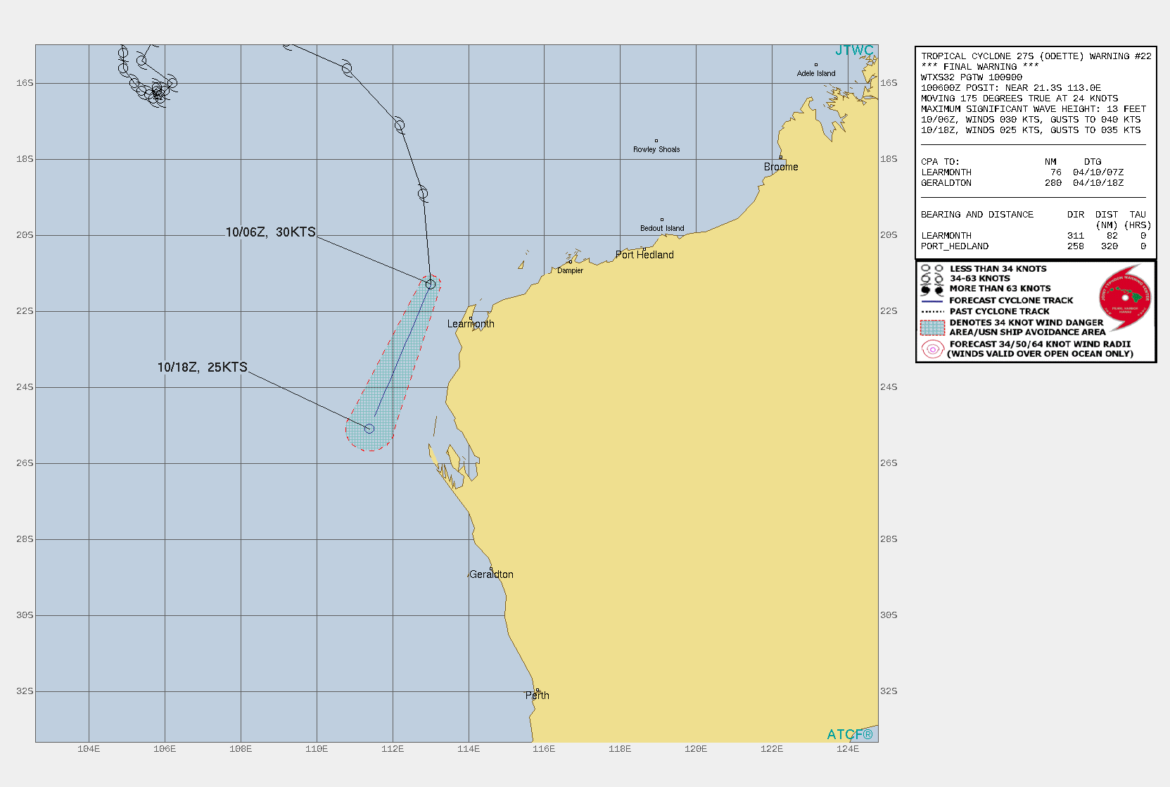
JTWC09Z發佈Final Warning
WTXS32 PGTW 100900
MSGID/GENADMIN/JOINT TYPHOON WRNCEN PEARL HARBOR HI//
SUBJ/TROPICAL CYCLONE 27S (ODETTE) WARNING NR 022//
RMKS/
1. TROPICAL CYCLONE 27S (ODETTE) WARNING NR 022   
   02 ACTIVE TROPICAL CYCLONES IN SOUTHIO
   MAX SUSTAINED WINDS BASED ON ONE-MINUTE AVERAGE
   WIND RADII VALID OVER OPEN WATER ONLY
    ---
   WARNING POSITION:
   100600Z --- NEAR 21.3S 113.0E
     MOVEMENT PAST SIX HOURS - 175 DEGREES AT 24 KTS
     POSITION ACCURATE TO WITHIN 040 NM
     POSITION BASED ON CENTER LOCATED BY SATELLITE
   PRESENT WIND DISTRIBUTION:
   MAX SUSTAINED WINDS - 030 KT, GUSTS 040 KT
   WIND RADII VALID OVER OPEN WATER ONLY
   DISSIPATING AS A SIGNIFICANT TROPICAL CYCLONE OVER WATER
   REPEAT POSIT: 21.3S 113.0E
    ---
   FORECASTS:
   12 HRS, VALID AT:
   101800Z --- 25.1S 111.4E
   MAX SUSTAINED WINDS - 025 KT, GUSTS 035 KT
   WIND RADII VALID OVER OPEN WATER ONLY
   DISSIPATED AS A SIGNIFICANT TROPICAL CYCLONE OVER WATER
    ---
REMARKS:
100900Z POSITION NEAR 22.3S 112.6E.
10APR21. TROPICAL CYCLONE 27S (ODETTE), LOCATED APPROXIMATELY 86
NM NORTHWEST OF LEARMONTH, AUSTRALIA, HAS TRACKED SOUTHWARD AT 24
KNOTS OVER THE PAST SIX HOURS. ANIMATED MULTISPECTRAL SATELLITE
IMAGERY (MSI) INDICATES TC ODETTE CONTINUES TO SPIRAL INWARDS
TOWARDS TC 26S AS PART OF FUJIWHARA INTERACTION. THE SYSTEM HAS
RAPIDLY WEAKENED, THOUGH THERE HAS BEEN A FLARE UP IN DEEP
CONVECTION NEAR THE CENTER IN THE PAST FEW HOURS, LIKELY A RESULT OF
CONVERGENCE FLOW WITH THE OUTER BANDS OF TC 26S. THE INITIAL
POSITION IS PLACED WITH MODERATE CONFIDENCE BASED ON A MANUAL TRACK
OF THE LOW LEVEL VORTEX THROUGH THE ANIMATED VISIBLE IMAGERY. THE
OVERALL SYSTEM INTENSITY HAS BEEN LOWERED TO 30 KNOTS BASED ON A
PGTW DVORAK INTENSITY ESTIMATE OF T2.0 (30 KTS). AUTOMATED CIMSS ADT
ESTIMATES ARE MUCH HIGHER BUT ARE CONSIDERED UNREALISTIC DUE TO
FIXING ON THE TRANSIENT CONVECTIVE ACTIVITY. AN EARLIER 100012Z
ASCAT-A PASS REVEALED A VERY SMALL AREA OF GALE FORCE WINDS IN THE
EASTERN HEMISPHERE, BUT THESE ARE NOT CONSIDERED REPRESENTATIVE OF
THE OVERALL INTENSITY, THOUGH NEAR-GALE FORCE WINDS COULD
POTENTIALLY STILL BE PRESENT ON THE EASTERN SIDE OF THE CIRCULATION.
ENVIRONMENTAL CONDITIONS ARE INCREASINGLY HOSTILE, WITH AN ESTIMATED
15-20 KNOTS OF EASTERLY VERTICAL WIND SHEAR (VWS) AND A CONSTRAINED
OUTFLOW REGIME WHICH IS INHIBITING THE SYSTEM. TC 27S WILL CONTINUE
TO TRACK TOWARDS THE SOUTHWEST, SPIRALING CLOSER TO TC 26S WHILE
FULLY DISSIPATING AS A DISTINCT CIRCULATION WITHIN THE NEXT 12
HOURS. DYNAMIC MODEL GUIDANCE IS IN OVERALL GOOD AGREEMENT ON THE
MERGER AND DISSIPATION SCENARIO, LENDING HIGH CONFIDENCE TO THE JTWC
FORECAST TRACK. THIS IS THE FINAL WARNING ON THIS SYSTEM BY THE
JOINT TYPHOON WRNCEN PEARL HARBOR HI. THE SYSTEM WILL BE CLOSELY
MONITORED FOR SIGNS OF REGENERATION. MAXIMUM SIGNIFICANT WAVE HEIGHT
AT 100600Z IS 13 FEET. REFER TO TROPICAL CYCLONE 26S (SEROJA)
WARNINGS (WTXS31 PGTW) FOR SIX-HOURLY UPDATES.//
NNNN
9E6321EA-C026-48DC-8110-F05A6604207B.gif 095F23CA-20D5-49AE-B85D-E08D253B0B2D.jpeg
回復

使用道具 舉報

簽到天數: 483 天

[LV.9]以壇為家II

dom|2021-4-10 21:50 | 顯示全部樓層
BoM發報最終報
IDW27700
TROPICAL CYCLONE TECHNICAL BULLETIN: AUSTRALIA - WESTERN REGION
Issued by AUSTRALIAN BUREAU OF METEOROLOGY TROPICAL CYCLONE WARNING CENTRE
at: 1316 UTC 10/04/2021
Name: Ex-Tropical Cyclone Odette
Identifier: 23U
Data At: 1200 UTC
Latitude: 23.5S
Longitude: 111.9E
Location Accuracy: within 50 nm [95 km]
Movement Towards: south southwest [198 deg]
Speed of Movement: 26 knots [49 km/h]
Maximum 10-Minute Wind: 30 knots [55 km/h]
Maximum 3-Second Wind Gust: 45 knots [85 km/h]
Central Pressure: 994 hPa
Radius of 34-knot winds NE quadrant:   
Radius of 34-knot winds SE quadrant:   
Radius of 34-knot winds SW quadrant:   
Radius of 34-knot winds NW quadrant:   
Radius of 48-knot winds NE quadrant:   
Radius of 48-knot winds SE quadrant:   
Radius of 48-knot winds SW quadrant:   
Radius of 48-knot winds NW quadrant:   
Radius of 64-knot winds:
Radius of Maximum Winds:   
Dvorak Intensity Code: 2.0
Pressure of outermost isobar: 1002 hPa
Radius of outermost closed isobar: 25 nm [45 km]
FORECAST DATA
Date/Time    : Location    : Loc. Accuracy: Max Wind   : Central Pressure
[UTC]        : degrees     :      nm  [km]: knots[km/h]: hPa
+06:  10/1800:             :              :            :     
+12:  11/0000:             :              :            :
+18:  11/0600:             :              :            :     
+24:  11/1200:             :              :            :     
+36:  12/0000:             :              :            :     
+48:  12/1200:             :              :            :     
+60:  13/0000:             :              :            :     
+72:  13/1200:             :              :            :     
+96:  14/1200:             :              :            :     
+120: 15/1200:             :              :            :     
REMARKS:
Ex-Tropical Cyclone Odette has weakened to the point that a low level
circulation is almost undefined. The low level system centre has been obscured
due to overcast as convection becomes more concentrated into neighbouring
Tropical Cyclone Seroja.

Intensity has been set at 30kt, with no gales attributed to the system.
Dvorak analysis is quite subjective with CI=2.0 based on a shear pattern <1 1/4
from the centre.

Easterly shear dominates the system and will become increasingly unfavourable as
the system tracks rapidly south southwest under the steering influence of
Tropical Cyclone Seroja.
Copyright Commonwealth of Australia
==
There will be no further bulletins for this system.
E26860E2-DFAA-4187-BB1B-98225F259F27.png
回復

使用道具 舉報

1234
快速回覆
您需要登錄後才可以回帖 登錄 | 立即加入

本版積分規則

本平台僅供學術討論之用,預報應以氣象局為準

威普網站虛擬主機贊助公司

臺灣第一個天氣類型社群平台 即時天氣資訊、精準颱風動態

線上客服
FB傳送訊息
廣告行銷
精準行銷 物超所值
官方粉專
發佈 快速回復 返回頂部 返回列表