開啟輔助訪問
 找回密碼
 立即加入

21E.Polo 持續西行 逐步消亡

簽到天數: 1650 天

[LV.Master]伴壇終老

2020-11-14 02:55 | 顯示全部樓層
  熱帶風暴  
編號:21 E
名稱:Polo
044701smes7uo799v4ombm.jpg
  基本資料  
擾動編號日期:2020 11 14 02
命名日期  :2020 11 18 23
撤編日期  :2020 11 20 08
登陸地點  :

  巔峰時期資料  
近中心最強風速 :40  kt ( TS )
海平面最低氣壓 :1004 百帕

  擾動編號資料  

98E.INVEST.15kts-1008mb-14N-109W
20201113.1750.goes-17.ir.98E.INVEST.15kts.1008mb.14N.109W.100pc.jpg

  NHC:40%  
1. Showers and thunderstorms have increased this morning in association
with an area of low pressure located several hundred miles southwest
of the coast of Mexico.  Environmental conditions are forecast to be
conducive for some gradual development, and a tropical depression is
likely to form late this weekend or early next week as the system
moves slowly toward the west-northwest away from the coast of
Mexico.
* Formation chance through 48 hours...medium...40 percent.
* Formation chance through 5 days...high...70 percent.

two_pac_2d1.png two_pac_5d1.png 以上資料來自:NHC、颱風論壇整理製作

評分

參與人數 1水氣能量 +15 +1 收起 理由
t02436 + 15 + 1

查看全部評分

回復

使用道具 舉報

簽到天數: 1650 天

[LV.Master]伴壇終老

老農民版夜神月|2020-11-15 03:35 | 顯示全部樓層
NHC展望提升至50%
EP, 98, 2020111418,   , BEST,   0, 135N, 1074W,  25, 1008, LO
1. Shower and thunderstorm activity remains disorganized in association
with a broad area of low pressure located several hundred miles
southwest of the coast of southern Mexico.  However, environmental
conditions appear conducive for gradual development, and a tropical
depression is likely to form early next week as the system moves
slowly west-northwestward or northwestward away from the coast of
Mexico. By late next week, conditions are expected to become
unfavorable for further development.
* Formation chance through 48 hours...medium...50 percent.
* Formation chance through 5 days...high...70 percent.
two_pac_2d1 (9).png 20201114.1820.goes-17.vis.2km.98E.INVEST.25kts.1008mb.13.5N.107.4W.pc.jpg

LATEST - 2020-11-15T032647.684.jpg 98E_gefs_latest.png
回復

使用道具 舉報

簽到天數: 483 天

[LV.9]以壇為家II

dom|2020-11-15 15:05 | 顯示全部樓層
NHC06z把展望降回30%,結構仍然有待整合,周遭乾空氣問題較為嚴重
ZCZC MIATWOEP ALL
TTAA00 KNHC DDHHMM

Tropical Weather Outlook
NWS National Hurricane Center Miami FL
1000 PM PST Sat Nov 14 2020

For the eastern North Pacific...east of 140 degrees west longitude:

1. A broad and disorganized area of low pressure located several
hundred miles southwest of the coast of southern Mexico continues to
produce minimal shower activity. Slow development of this system is
possible, and a tropical depression could form in a few days as the
system moves slowly west-northwestward or northwestward away from
the coast of Mexico. By late next week, conditions are expected to
become unfavorable for further development.
* Formation chance through 48 hours...low...30 percent.
* Formation chance through 5 days...medium...50 percent. Forecaster Zelinsky

two_pac_2d1.png 2020ep98_16kmgwvp_202011141510.gif goes17_truecolor_98E_202011150425.gif

回復

使用道具 舉報

簽到天數: 1650 天

[LV.Master]伴壇終老

老農民版夜神月|2020-11-17 01:49 | 顯示全部樓層
過去半天對流有所加強,整體環流亦變得較有組織,NHC展望重新提升至Medium,40%
1. Showers and thunderstorms associated with a broad area of low
pressure located several hundred miles southwest of the coast of
southern Mexico have increased and become a little better
organized since yesterday.  Although environmental conditions are
forecast to be only marginally conducive, some additional
development is possible, and the system could become a short-lived
tropical depression within the next couple of days.  The low is
forecast to move west-northwestward or northwestward at about 10 mph
away from the coast of Mexico.  Conditions are expected to become
unfavorable for further development around midweek.
* Formation chance through 48 hours...medium...40 percent.
* Formation chance through 5 days...medium...40 percent.

two_pac_2d1.png goes17_ir_98E_202011161505.gif
20201116.1354.f17.91pct91h91v.98E.INVEST.25kts.1008mb.14.1N.107.2W.100pc.jpg LATEST.jpg
回復

使用道具 舉報

簽到天數: 3206 天

[LV.Master]伴壇終老

king111807|2020-11-17 12:03 | 顯示全部樓層
NHC展望在提升至50%
1. Showers and thunderstorms continue to become better organized in
association with a broad area of low pressure located several
hundred miles southwest of the coast of southern Mexico.  Although
environmental conditions are only somewhat conducive for
development, a short-lived tropical depression could still form
within the next couple of days as the low moves west-northwestward
or northwestward at about 10 mph, away from the coast of Mexico.  By
midweek, conditions are forecast to become increasingly unfavorable
for further development.
* Formation chance through 48 hours...medium...50 percent.
* Formation chance through 5 days...medium...50 percent.
two_pac_2d1.png
回復

使用道具 舉報

簽到天數: 1650 天

[LV.Master]伴壇終老

老農民版夜神月|2020-11-18 01:03 來自手機 | 顯示全部樓層
JTWC1530Z發布TCFA
WTPN21 PHNC 171530
MSGID/GENADMIN/JOINT TYPHOON WRNCEN PEARL HARBOR HI//
SUBJ/TROPICAL CYCLONE FORMATION ALERT (INVEST 98E)//
RMKS/
1. FORMATION OF A SIGNIFICANT TROPICAL CYCLONE IS POSSIBLE WITHIN
160 NM EITHER SIDE OF A LINE FROM 14.3N 110.8W TO 15.9N 118.1W
WITHIN THE NEXT 06 TO 24 HOURS. AVAILABLE DATA DOES NOT JUSTIFY
ISSUANCE OF NUMBERED TROPICAL CYCLONE WARNINGS AT THIS TIME. WINDS
IN THE AREA ARE ESTIMATED TO BE 20 TO 25 KNOTS. METSAT IMAGERY AT
171500Z INDICATES THAT A CIRCULATION CENTER IS LOCATED NEAR 14.4N
111.4W. THE SYSTEM IS MOVING WESTWARD AT 10 KNOTS.
2. REMARKS: AN AREA OF CONVECTION (INVEST 98E) HAS PERSISTED NEAR
14.4N 111.4W, APPROXIMATELY 257NM SOUTH OF SOCORRO, MEXICO. ANIMATED
ENHANCED INFRARED SATELLITE IMAGERY DEPICTS A CONSOLIDATING SYSTEM
WITH PERSISTENT DEEP CONVECTION AND FORMATIVE BANDING. A 171143Z
SSMIS 37GHZ MICROWAVE IMAGE DEPICTS CURVED CONVECTIVE BANDING
WRAPPING TIGHTLY INTO A RAGGED BUT DEFINED LOW-LEVEL CIRCULATION
CENTER. UPPER-LEVEL ANALYSIS REVEALS A MARGINALLY-FAVORABLE
ENVIRONMENT WITH LOW VERTICAL WIND SHEAR AND FAIR POLEWARD OUTFLOW.
SST VALUES OF 28C ARE CONDUCIVE FOR FURTHER DEVELOPMENT. GLOBAL
MODELS INDICATE A WEST-NORTHWESTWARD TRACK OVER THE NEXT 1-2 DAYS
WITH LIMITED DEVELOPMENT. MAXIMUM SUSTAINED SURFACE WINDS ARE
ESTIMATED AT 20 TO 25 KNOTS. MINIMUM SEA LEVEL PRESSURE IS ESTIMATED
TO BE NEAR 1004 MB. THE POTENTIAL FOR THE DEVELOPMENT OF A
SIGNIFICANT TROPICAL CYCLONE WITHIN THE NEXT 24 HOURS IS HIGH.
3. THIS ALERT WILL BE REISSUED, UPGRADED TO WARNING OR CANCELLED BY
181530Z.//
NNNN
ep9820.gif 20201117.1620.goes-17.vis.2km.98E.INVEST.25kts.1008mb.14.4N.111.4W.pc.jpg 20201117.1341.f17.91pct91h91v.98E.INVEST.25kts.1008mb.14.4N.111.4W.055pc.jpg goes17_ir_98E_202011171425.gif
回復

使用道具 舉報

簽到天數: 1650 天

[LV.Master]伴壇終老

老農民版夜神月|2020-11-18 02:56 | 顯示全部樓層
最新風場掃描出來的結構還不錯,NHC在報文中亦表示98E有機會在稍晚獲得升格
NHC18Z展望提升至High,70%
1. Visible satellite imagery indicates that the circulation of the
area of low pressure located several hundred miles south-southwest
of the southern tip of the Baja California peninsula has become
better defined, and the associated shower and thunderstorm
activity is also showing signs of organization.  Although
environmental conditions are only somewhat conducive for additional
development, only a slight increase in organization of the system
would result in the formation of a short-lived tropical depression
late today or tomorrow as it moves west-northwestward or
northwestward at about 10 mph.  Conditions are forecast to become
increasingly unfavorable for further development on Thursday.
* Formation chance through 48 hours...high...70 percent.
* Formation chance through 5 days...high...70 percent.
two_pac_2d1.png GOES18302020322ASDw0w.jpg
LATEST.jpg
回復

使用道具 舉報

簽到天數: 1650 天

[LV.Master]伴壇終老

老農民版夜神月|2020-11-18 04:47 | 顯示全部樓層
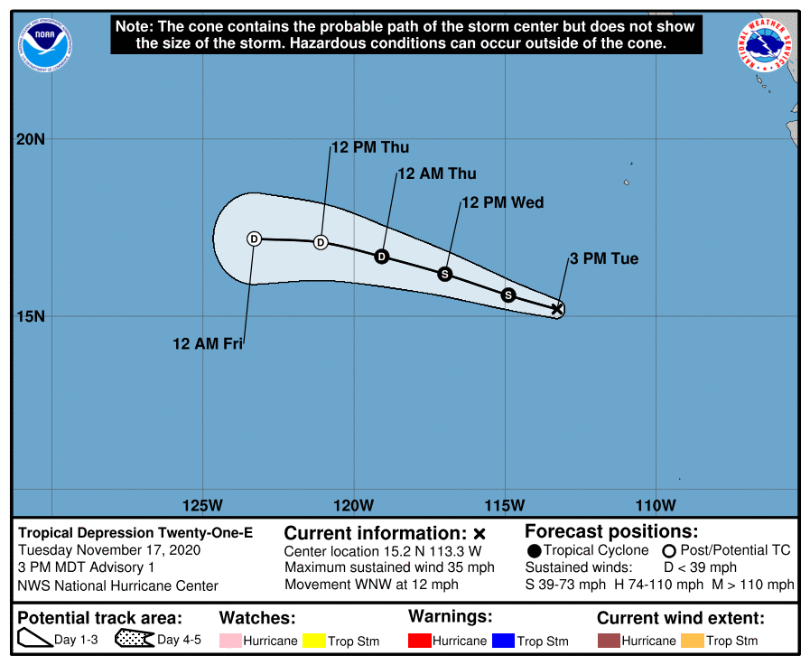
NHC21Z升格TD21E,首報看好能獲得命名
916
WTPZ41 KNHC 172042
TCDEP1

Tropical Depression Twenty-One-E Discussion Number   1
NWS National Hurricane Center Miami FL       EP212020
300 PM MDT Tue Nov 17 2020

Visible satellite imagery and recent ASCAT data indicate that the
circulation of the area of low pressure located well south-southwest
of Baja California has become better defined today. The associated
convective activity has also become organized in a band around the
western and southwestern portions of the circulation. Therefore,
the system is being classified as a tropical depression with winds
of 30 kt, as indicated by the scatterometer data and a T2.0 (30 kt)
Dvorak classification from TAFB.

The depression is currently located over SSTs of around 28 deg C,
and within a low shear environment.  These conditions are conducive
for strengthening, but the surrounding mid-level environment is
fairly dry which is likely to limit intensification.  Most of the
intensity guidance calls for the system to become a short-lived
tropical storm, and so does the official forecast.  After 24 hours,
increasing upper-level westerly winds, cooler SSTs, and even less
favorable thermodynamic conditions should cause the cyclone to
weaken.  The system is likely to become a remnant low in about 48
hours, and the global models show it degenerating into a trough of
low pressure in 60-72 hours, which is also indicated in the NHC
forecast.

The initial motion estimate is 285/11 kt.  A mid-level ridge that
extends westward from northern Mexico over the eastern Pacific
should steer the system west-northwestward for the next couple of
days.  After that time, the cyclone is likely to turn more westward
as it weakens and is steered by the low-level trade wind flow.  The
track guidance is in good agreement, and the NHC forecast is near
the middle of the guidance envelope.

FORECAST POSITIONS AND MAX WINDS

INIT  17/2100Z 15.2N 113.3W   30 KT  35 MPH
12H  18/0600Z 15.6N 114.9W   35 KT  40 MPH
24H  18/1800Z 16.2N 117.0W   35 KT  40 MPH
36H  19/0600Z 16.7N 119.1W   30 KT  35 MPH
48H  19/1800Z 17.1N 121.1W   25 KT  30 MPH...POST-TROP/REMNT LOW
60H  20/0600Z 17.2N 123.3W   20 KT  25 MPH...POST-TROP/REMNT LOW
72H  20/1800Z...DISSIPATED

$$
Forecaster Brown
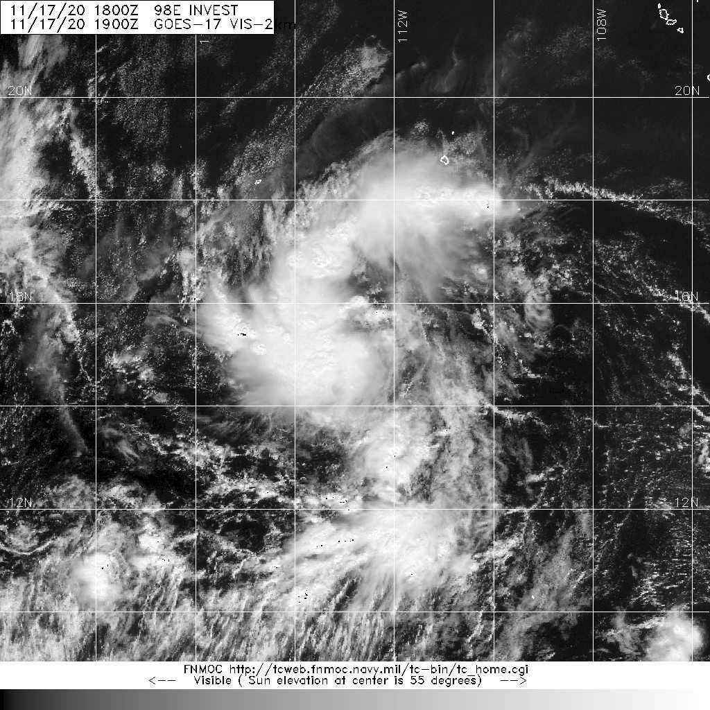
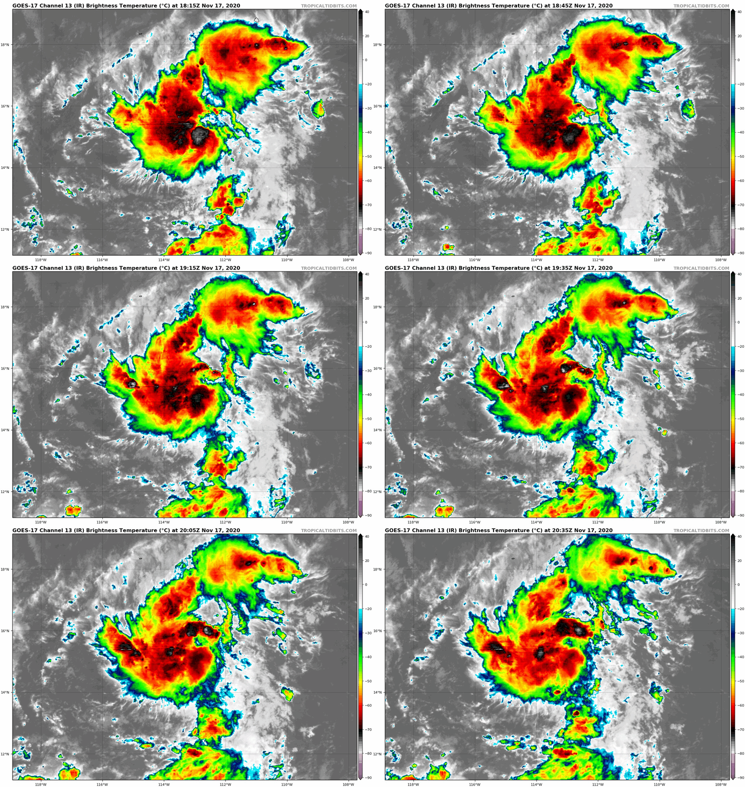
204410_5day_cone_with_line_and_wind.png 20201117.1900.goes-17.vis.2km.98E.INVEST.30kts.1007mb.15N.112.8W.pc.jpg
goes17_ir_98E_202011171815.gif
回復

使用道具 舉報

12下一頁
快速回覆
您需要登錄後才可以回帖 登錄 | 立即加入

本版積分規則

本平台僅供學術討論之用,預報應以氣象局為準

威普網站虛擬主機贊助公司

臺灣第一個天氣類型社群平台 即時天氣資訊、精準颱風動態

線上客服
FB傳送訊息
廣告行銷
精準行銷 物超所值
官方粉專
發佈 快速回復 返回頂部 返回列表