開啟輔助訪問
 找回密碼
 立即加入

28L.Zeta 登陸路州 追平2005年命名數量

簽到天數: 601 天

[LV.9]以壇為家II

2020-10-23 15:02 | 顯示全部樓層
  一級颶風  
編號:28 L
名稱:Zeta
044221y98ro8a9orl8w4r9.jpg
  基本資料  
擾動編號日期:2020 10 23 14
命名日期  :2020 10 25 14
撤編日期  :2020 10 30 08
登陸地點  :
墨西哥-圖盧姆
                       美國-路易斯安那州-可可德里

  巔峰時期資料  
近中心最強風速 :70 kt ( Cat.1 )
海平面最低氣壓 :981 百帕

  擾動編號資料  

95L.INVEST.25kts-1008mb-18.8N-81.3W
20201023.0640.goes-16.ir.95L.INVEST.25kts.1008mb.18.8N.81.3W.100pc.jpg
1. A broad trough of low pressure, located over the western Caribbean
Sea, is producing a large area of showers and thunderstorms mainly
east of the trough. Surface observations, satellite-derived surface
wind data, and radar data indicate that a low pressure system has
developed along the trough axis just south of Grand Cayman Island.
Some gradual development of the low is possible during the next few
days while it moves northwestward to northward across western or
central Cuba on Saturday, then turning northward to northeastward
across the southeastern Gulf of Mexico, Straits of Florida, and the
central Bahamas on Sunday. Regardless of development, locally heavy
rainfall will be possible over portions of the Cayman Islands, Cuba,
South Florida, and the Bahamas through early next week.
* Formation chance through 48 hours...low...30 percent.
* Formation chance through 5 days...medium...40 percent.

two_atl_2d1.png
以上資料來自:NHC、颱風論壇整理製作

評分

參與人數 1水氣能量 +15 +1 收起 理由
king111807 + 15 + 1 熱帶擾動首帖

查看全部評分

回復

使用道具 舉報

簽到天數: 483 天

[LV.9]以壇為家II

dom|2020-10-23 19:50 | 顯示全部樓層
NHC提升展望至medium 50%/60%
1. A broad area of low pressure located near Grand Cayman Island is producing a large area of showers and thunderstorms mainly east and south of the center. This system has become much better organized since yesterday, and a tropical depression could form during the next couple of days while the low moves slowly toward the northwest. This system is now anticipated to move near western Cuba this weekend and move slowly across the southeastern Gulf of Mexico by early next week. Regardless of development, locally heavy rainfall will be possible over portions of the Cayman Islands, Cuba, southern Florida and the Keys, and the northwestern Bahamas through the weekend.
* Formation chance through 48 hours...medium...50 percent.
* Formation chance through 5 days...medium...60 percent.
two_atl_2d1.png
回復

使用道具 舉報

簽到天數: 1650 天

[LV.Master]伴壇終老

老農民版夜神月|2020-10-24 03:00 | 顯示全部樓層
本帖最後由 老農民版夜神月 於 2020-10-24 04:12 編輯

NHC展望提升High,70%
1. Satellite images and radar data indicate that the broad area of low
pressure located just west of Grand Cayman Island is gradually
becoming better defined.  Environmental conditions appear conducive
for further development, and a tropical depression will likely form
during the next day or two while the low drifts toward the
northwest. The system could move near western Cuba by Sunday and
move slowly across the southeastern Gulf of Mexico by early next
week. Interests in western Cuba, the Florida Keys, and southern
Florida should monitor the progress of this disturbance. Regardless
of development, locally heavy rainfall will be possible over
portions of the Cayman Islands, Jamaica, Cuba, southern Florida,
the Florida Keys, and the northwestern Bahamas through the weekend.
* Formation chance through 48 hours...high...70 percent.
* Formation chance through 5 days...high...70 percent.

two_atl_2d1 (2) (11).png 20201023.1820.goes-16.vis.2km.95L.INVEST.25kts.1007mb.19.4N.81.9W.pc.jpg
LATEST - 2020-10-24T025818.156.jpg
回復

使用道具 舉報

簽到天數: 1650 天

[LV.Master]伴壇終老

老農民版夜神月|2020-10-24 04:12 | 顯示全部樓層
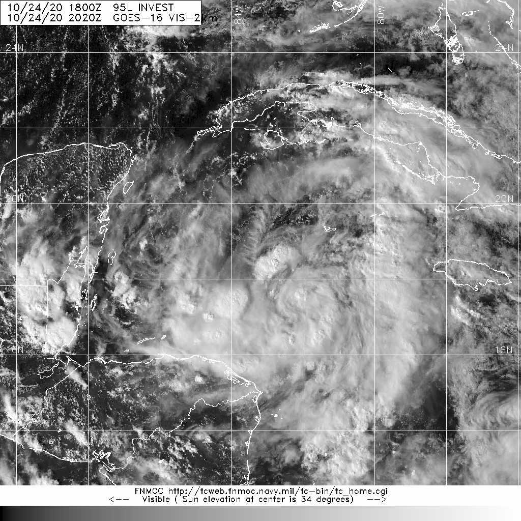
FWC-N2000Z發布TCFA
WTNT21 KNGU 232000
SUBJ/TROPICAL CYCLONE FORMATION ALERT//
RMKS/1. FORMATION OF A SIGNIFICANT TROPICAL CYCLONE IS POSSIBLE
WITHIN 100 NM EITHER SIDE OF A LINE FROM 19.4N 81.9W TO 20.8N 82.7W
WITHIN THE NEXT 24 HOURS. AVAILABLE DATA DOES NOT JUSTIFY
ISSUANCE OF NUMBERED TROPICAL CYCLONE WARNINGS AT THIS TIME.
WINDS IN THE AREA ARE ESTIMATED TO BE 25 KNOTS. METSAT
IMAGERY AT 231800Z INDICATES THAT A CIRCULATION CENTER IS LOCATED
NEAR 19.4N 81.9W. THE SYSTEM IS MOVING NORTH-NORTHWESTWARD AT 04
KNOTS.
2. A BROAD AREA OF LOW PRESSURE IS LOCATED NEAR THE GRAND CAYMAN
ISLAND. ALTHOUGH ASSOCIATED SURFACE PRESSURES HAVE NOT
FALLEN SIGNIFICANTLY DURING THE PAST 24 HOURS, THE SURFACE
CIRCULATION IS SLOWLY BECOMING BETTER DEFINED. UPPER LEVEL WINDS
ARE CONDUCIVE FOR FURTHER DEVELOPMENT AND A TROPICAL DEPRESSION
IS EXPECTED TO FORM DURING THE NEXT 24 HOURS AS IT DRIFTS WEST-
NORTHWESTWARD TO NORTHWESTWARD MOVING NEAR WESTERN CUBA AND THE
YUCATAN CHANNEL OVER THE WEEKEND.
3. THIS ALERT WILL BE REISSUED, UPGRADED TO WARNING OR CANCELLED
BY 242000Z.//
BT
#0001
NNNN
al952020.gif 95L_gefs_latest (1).png
cfaab82c-a058-406e-a9ef-478806bcdb90.jpeg
回復

使用道具 舉報

簽到天數: 601 天

[LV.9]以壇為家II

霧峰追風者|2020-10-24 19:58 | 顯示全部樓層
1. Satellite, radar and surface data indicate that a broad area of low
pressure located just southwest of Grand Cayman Island is gradually
becoming better organized, with a better defined wind circulation,
increasing thunderstorm activity and falling surface pressures since
yesterday. Environmental conditions are conducive for further
development, and a tropical depression is expected to form within
the next day or so while the low drifts toward the north and
northwest.  The system could move near western Cuba on Monday and
move slowly across the southeastern Gulf of Mexico by Tuesday.  
Interests in western Cuba, the Florida Keys, and the Yucatan
Peninsula should monitor the progress of this disturbance.  A NOAA
Hurricane Hunter reconnaissance aircraft is scheduled to investigate
the disturbance this afternoon. Regardless of development, locally
heavy rainfall will be possible over portions of the Cayman Islands,
Jamaica and Cuba through early next week.
* Formation chance through 48 hours...high...90 percent.
* Formation chance through 5 days...high...90 percent.
two_atl_2d1.png
回復

使用道具 舉報

簽到天數: 1650 天

[LV.Master]伴壇終老

老農民版夜神月|2020-10-25 05:01 | 顯示全部樓層
NHC21Z升格TD28L,首報上望65節
ZCZC MIATCDAT3 ALL
TTAA00 KNHC DDHHMM

Tropical Depression Twenty-Eight Discussion Number   1
NWS National Hurricane Center Miami FL       AL282020
500 PM EDT Sat Oct 24 2020

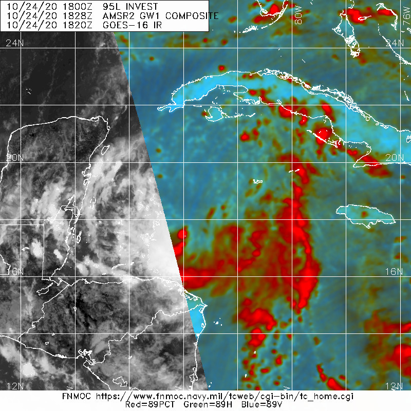
Satellite imagery and NOAA Hurricane Hunter aircraft data indicate
that the broad area of low pressure that NHC has been following for
the past couple of days has consolidated enough to be considered a
tropical depression.  GOES-16 1-minute data shows the center pretty
clearly, with a new area of convection close by, and a minimum
pressure of 1005 mb was reported by the aircraft in that area. The
surface winds were generally fairly light within about a degree of
the center, but data from the plane supports a 25-kt initial
intensity.

The tropical depression hasn't been moving much, but recently it has
started at least drifting toward the north-northwest.  A shortwave
trough moving across the southeastern United States should keep the
cyclone in a rather weak steering pattern during the next day or so,
with only a northwest drift anticipated.   Mid-level ridging should
build over the northern Gulf of Mexico on Monday, forcing the
depression to move faster to the west-northwest toward the Yucatan
Peninsula or Channel.  The ridge shouldn't last too long, however,
with a substantial upper-level low forecast to eject out of the
southwestern United States in a few days, causing the tropical
cyclone to sharply turn to the north and northeast on Wednesday.  
The guidance isn't in very good agreement, and these types of trough
ejection scenarios can have significant timing differences.  At
this time, the NHC track forecast leans a little more on the global
models than the regional hurricane models, and is just west of the
model consensus.

While the large-scale shear is fairly light at the moment, the low-
and mid-level circulations of the depression are not well-aligned.
Thus, it might take some time for the system to strengthen despite
low shear and very warm waters.  In a day or two, the depression
will likely have a structure that supports a faster rate of
strengthening, and the intensification rate is increased while the
cyclone is near the Yucatan.  Although the forecast shows the
system reaching hurricane strength in the southern Gulf of Mexico,
this is rather uncertain given the potential land interaction and
only a narrow area of favorable upper-level winds.  A combination of
cooler shelf waters and increasing shear will likely weaken the
cyclone below hurricane strength as it approaches the northern Gulf
Coast. However, strong tropical storms can still produce significant
storm surge, rainfall, and wind impacts, and residents in this
region will yet again need to monitor another tropical cyclone
moving northward across the Gulf.

KEY MESSAGES:

1. The depression is forecast to strengthen to a tropical storm
Sunday and could bring tropical storm conditions to extreme western
Cuba on Monday, where a Tropical Storm Watch is in effect. There is
also a risk of tropical storm conditions in the northern Yucatan
Peninsula of Mexico Monday night and Tuesday.

2. Through Wednesday, heavy rainfall is expected across portions of
central and western Cuba, the Cayman Islands, Jamaica, the northeast
Yucatan peninsula of Mexico, southern Florida and the Keys. This
rainfall may lead to flash flooding in urban areas.

3. The system is forecast to approach the northern Gulf Coast as a
tropical storm on Wednesday, and could bring storm surge, rainfall,
and wind impacts to areas from Louisiana to the Florida Panhandle.
Residents in these areas should monitor the progress of the
depression and updates to the forecast.

FORECAST POSITIONS AND MAX WINDS

INIT  24/2100Z 18.7N  83.0W   25 KT  30 MPH
12H  25/0600Z 19.0N  83.2W   30 KT  35 MPH
24H  25/1800Z 19.5N  83.5W   35 KT  40 MPH
36H  26/0600Z 20.1N  84.2W   40 KT  45 MPH
48H  26/1800Z 20.9N  85.6W   45 KT  50 MPH
60H  27/0600Z 22.0N  87.5W   55 KT  65 MPH
72H  27/1800Z 23.4N  89.4W   65 KT  75 MPH
96H  28/1800Z 27.5N  91.0W   55 KT  65 MPH
120H  29/1800Z 35.5N  84.5W   25 KT  30 MPH...POST-TROP/EXTRATROP

$$
Forecaster Blake

NNNN
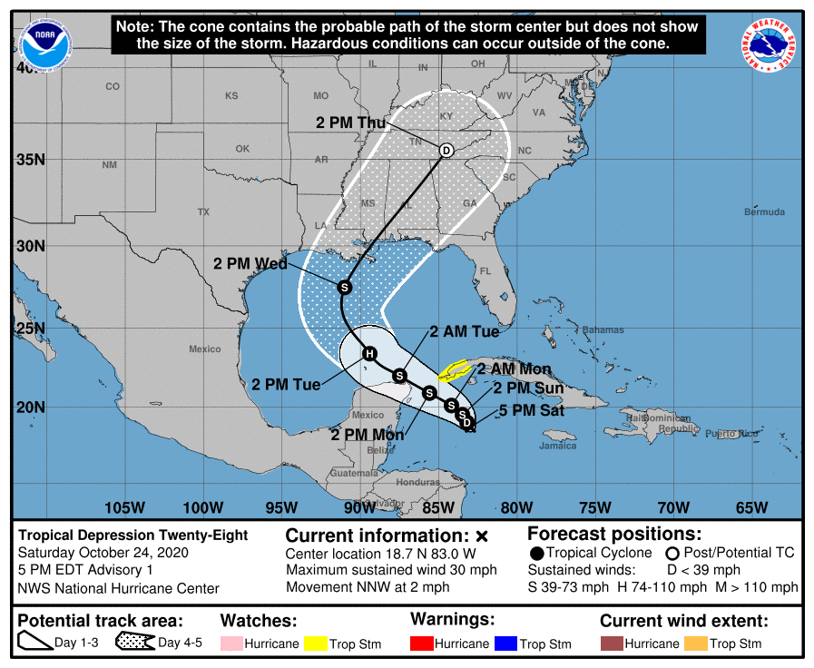
205453_5day_cone_with_line_and_wind.png 20201024.2020.goes-16.vis.2km.95L.INVEST.25kts.1006mb.18.5N.83.2W.pc.jpg
20201024.1828.gw1.89pct89h89v.95L.INVEST.25kts.1006mb.18.5N.83.2W.61pc.jpg


回復

使用道具 舉報

簽到天數: 483 天

[LV.9]以壇為家II

dom|2020-10-25 14:27 | 顯示全部樓層
本帖最後由 dom 於 2020-10-25 14:37 編輯

命名Zeta, 已平2005年命名數量
WTNT33 KNHC 250550
TCPAT3

BULLETIN
Tropical Storm Zeta Intermediate Advisory Number 2A
NWS National Hurricane Center Miami FL AL282020
200 AM EDT Sun Oct 25 2020

...DEPRESSION STRENGTHENS INTO TROPICAL STORM ZETA...
...EXPECTED TO PRODUCE HEAVY RAINFALL AND TROPICAL-STORM-FORCE
WINDS ACROSS PORTIONS OF THE NORTHWESTERN CARIBBEAN...


SUMMARY OF 200 AM EDT...0600 UTC...INFORMATION
----------------------------------------------
LOCATION...18.5N 83.5W
ABOUT 250 MI...400 KM SSE OF THE WESTERN TIP OF CUBA
ABOUT 260 MI...415 KM ESE OF COZUMEL MEXICO
MAXIMUM SUSTAINED WINDS...40 MPH...65 KM/H
PRESENT MOVEMENT...STATIONARY
MINIMUM CENTRAL PRESSURE...1002 MB...29.59 INCHES
goes16_ir_28L_202010250615_lat18.9-lon276.9.jpg AL282020_5day_cone_no_line_and_wind.png 28L_intensity_latest.png
回復

使用道具 舉報

簽到天數: 1650 天

[LV.Master]伴壇終老

老農民版夜神月|2020-10-27 04:42 | 顯示全部樓層
NHC18Z升格C1
AL, 28, 2020102618,   , BEST,   0, 193N,  856W,  70,  981, HU
sm20201026.1820.goes-16.vis.2km.28L.ZETA.70kts.981mb.19.3N.85.6W.pc.jpg recon_AF309-0728A-ZETA.png GOES20202020300qjGDco.jpg
回復

使用道具 舉報

12下一頁
快速回覆
您需要登錄後才可以回帖 登錄 | 立即加入

本版積分規則

本平台僅供學術討論之用,預報應以氣象局為準

威普網站虛擬主機贊助公司

臺灣第一個天氣類型社群平台 即時天氣資訊、精準颱風動態

線上客服
FB傳送訊息
廣告行銷
精準行銷 物超所值
官方粉專
發佈 快速回復 返回頂部 返回列表