開啟輔助訪問
 找回密碼
 立即加入

23L.Wilfred 減弱消散

簽到天數: 601 天

[LV.9]以壇為家II

2020-9-15 12:03 | 顯示全部樓層
  熱帶風暴  
編號:23 L
名稱:Wilfred

230619qkuqzyzaia8arra6.jpg
  基本資料  
擾動編號日期:2020 09 15 11
命名日期  :2020 09 18 23
撤編日期  :2020 09 21 07
登陸地點  :

  巔峰時期資料  
近中心最強風速 :35  kt
( TS )
海平面最低氣壓 :1008 百帕

  擾動編號資料    

98L.INVEST.25kts-1010mb-8.6N-19.5W 20200915.0340.goes-16.ir.98L.INVEST.25kts.1010mb.8.6N.19.5W.100pc.jpg
2. A tropical wave located over the far eastern tropical Atlantic
continues to produce disorganized showers and thunderstorms. Some
development of this system is possible, and a tropical depression
could form during the next several days while the system moves
generally westward at 10 to 15 mph.
* Formation chance through 48 hours...low...30 percent.
* Formation chance through 5 days...medium...50 percent.

two_atl_2d2.png 以上資料來自:NHC、颱風論壇整理製作

評分

參與人數 1水氣能量 +15 +1 收起 理由
周子堯@FB + 15 + 1

查看全部評分

回復

使用道具 舉報

簽到天數: 1650 天

[LV.Master]伴壇終老

老農民版夜神月|2020-9-15 14:25 | 顯示全部樓層
NHC展望提升至Medium,50%
將逐漸西行,數值目前暫不看好強度
2. An area of low pressure has formed from a low-latitude tropical
wave located a few hundred miles south-southeast of the Cabo Verde
Islands.  Shower and thunderstorm activity has become more
concentrated during the past several hours, and a tropical
depression is likely to form during the next few days while the
system moves generally westward at 10 to 15 mph.
* Formation chance through 48 hours...medium...50 percent.
* Formation chance through 5 days...high...70 percent.

two_atl_2d2.png
EC
+48H
#!001_MicrosoftEdge_User_Default_WebNotes_Microsoft-Edge-Web-Notes-Windy-Win3976656.jpg
+120H
#!001_MicrosoftEdge_User_Default_WebNotes_Microsoft-Edge-Web-Notes-Windy-Win3849750.jpg
回復

使用道具 舉報

簽到天數: 2141 天

[LV.Master]伴壇終老

周子堯@FB|2020-9-18 21:12 | 顯示全部樓層
對流爆發,風速提升至35ktsNHC亦於12Z將評級升至high,預計有短暫發展機會
1. Showers and thunderstorms associated with an area of low pressure
located a few hundred miles southwest of the Cabo Verde Islands are
becoming better organized. Earlier satellite-derived wind data
indicated that this system does not yet have a well-defined center,
but it is producing winds near tropical-storm-force to its east.
Environmental conditions are expected to be conducive for additional
development during the next day or two and a tropical depression or
tropical storm is likely to form before the end of the week. This
system is forecast move west-northwestward at 10 to 15 mph through
the weekend.  For more information on this system, please see High
Seas Forecasts issued by the National Weather Service,
* Formation chance through 48 hours...high...70 percent.
* Formation chance through 5 days...high...70 percent.


two_atl_2d1 (1).png

20200918.0812.f17.ir.olsircomp.98L.INVEST.x.jpg
回復

使用道具 舉報

簽到天數: 1650 天

[LV.Master]伴壇終老

老農民版夜神月|2020-9-18 23:02 | 顯示全部樓層
本帖最後由 老農民版夜神月 於 2020-9-18 23:06 編輯

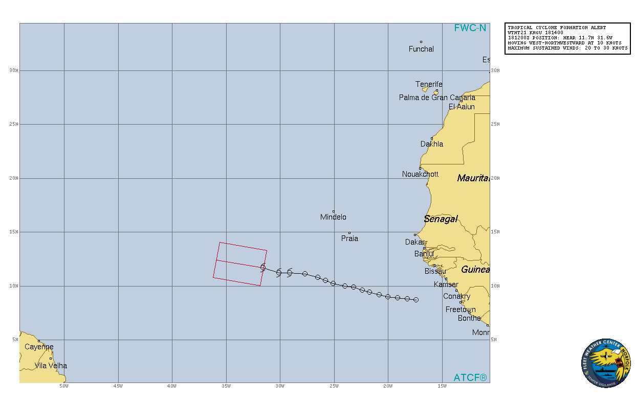
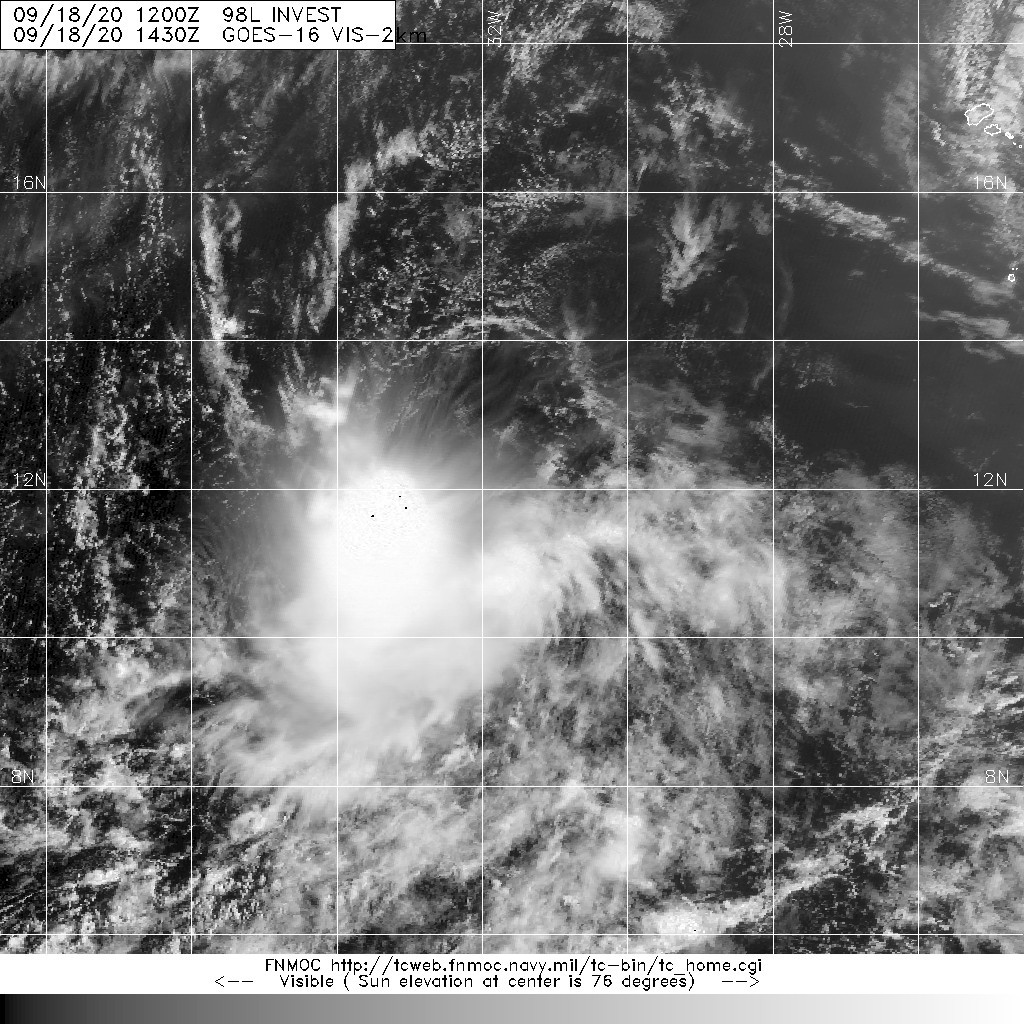
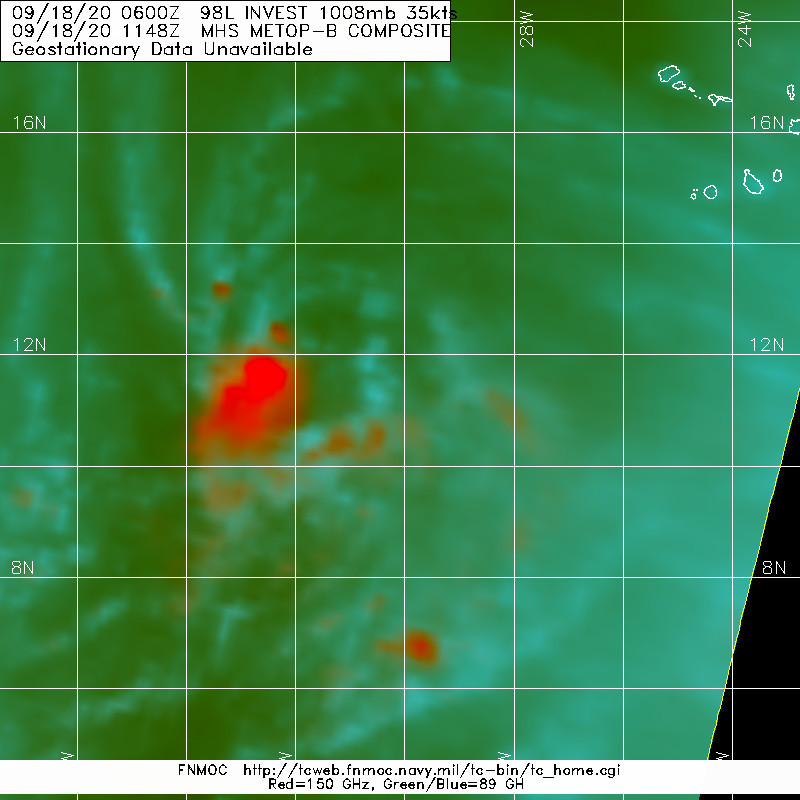
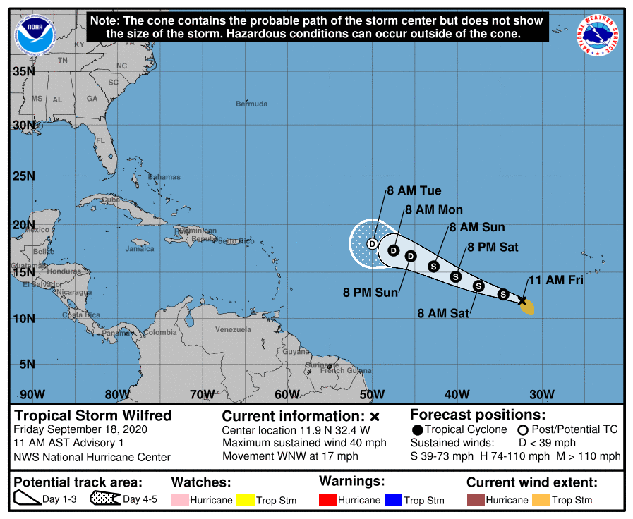
1400Z剛發布TCFA,15Z随即直接升格TS,命名Wilfred,上望40KT.北大的最早命名風暴紀錄持續推進中
WTNT43 KNHC 181435
TCDAT3

Tropical Storm Wilfred Discussion Number   1
NWS National Hurricane Center Miami FL       AL232020
1100 AM AST Fri Sep 18 2020

Satellite images indicate that the broad area of low pressure over
the eastern Atlantic has become better-defined this morning.  In
addition, scatterometer data also show a closed circulation, albeit
with some rain contamination causing some noise near the center.  
The initial wind speed is set to 35 kt, in accordance with
scatterometer data from last night (this morning's data missed the
eastern side of the storm).  Thus Wilfred has formed, continuing
the record-setting pace of the 2020 hurricane season since it is
the earliest 21st named storm on record, about 3 weeks earlier
than Vince of 2005.

Further intensification is possible during the next day or two
before a large upper-level trough is forecast to drop into the
path of the storm and stay there for at least a few days.  That
should promote weakening due to a substantial increase in shear, and
most of the global models show this tropical cyclone opening up
into a trough by day 5.  The official forecast follows this
scenario, and the NHC intensity forecast is a blend of the
consensus and corrected-consensus aids.

Wilfred is moving west-northwestward at about 15 kt.  The storm
is forecast to continue this motion for the next several days,
owing to steering from the low- to middle-level subtropical ridge.
The guidance is in fair agreement, and the official forecast is
near or west of the consensus at all times, leaning in the
direction of the HCCA corrected-consensus.  I should mention that
if Wilfred intensifies more than expected, it would probably move a
bit right of the forecast track for a while due to the expected
southwesterly flow at higher levels, before eventually turning back
west-northwestward.

FORECAST POSITIONS AND MAX WINDS

INIT  18/1500Z 11.9N  32.4W   35 KT  40 MPH
12H  19/0000Z 12.6N  34.6W   40 KT  45 MPH
24H  19/1200Z 13.5N  37.5W   40 KT  45 MPH
36H  20/0000Z 14.5N  40.2W   40 KT  45 MPH
48H  20/1200Z 15.6N  42.8W   35 KT  40 MPH
60H  21/0000Z 16.7N  45.5W   30 KT  35 MPH
72H  21/1200Z 17.3N  47.5W   30 KT  35 MPH
96H  22/1200Z 18.0N  50.0W   25 KT  30 MPH...POST-TROP/REMNT LOW
120H  23/1200Z...DISSIPATED

$$
Forecaster Blake
143359_5day_cone_no_line_and_wind.png al982020.20200918140839.gif 20200918.1430.goes-16.vis.2km.98L.INVEST.35kts.1008mb.11.7N.31.6W.pc.jpg 20200918.1148.metopb.89rgb.98L.INVEST.35kts.1008mb.11.2N.30.1W.095pc.jpg
回復

使用道具 舉報

簽到天數: 1650 天

[LV.Master]伴壇終老

老農民版夜神月|2020-9-21 01:38 | 顯示全部樓層
15Z已減弱為TD,未來將持續西行減弱並逐漸消亡
ZCZC MIATCDAT3 ALL
TTAA00 KNHC DDHHMM

Tropical Depression Wilfred Discussion Number   9
NWS National Hurricane Center Miami FL       AL232020
1100 AM AST Sun Sep 20 2020

First-light visible imagery of Wilfred shows a well-defined center
south of widespread - but not very well banded - deep convection.  
The improved positioning this morning allows for a more confident
assessment of its movement toward the west-northwest at 17 kt.  As
the system slowly winds down, it will be increasingly steered by
the low-level flow indicating a slower movement toward the west or
west-northwest until dissipation.  The new track forecast is
slightly farther west due to the faster initial motion within 36
hours, then slightly farther east afterward based upon the TVCN
track consensus approach.

While the ASCAT scatterometer passes this morning missed Wilfred's
center, ASCAT-B observed 30 kt peak winds in its northeastern
quadrant.  This value is used as the initial intensity, consistent
with both SAB and TAFB's Dvorak classifications.

The combination of outflow from Hurricane Teddy as well as winds on
the southern side of an impinging upper-level trough are causing
about 20 kt vertical shear from the west-northwest.  This shear
should increase over the next couple of days as Wilfred gets into
closer proximity with the trough.  The strong shear and dry
mid-level humidities should continue to cause a reduction of the
deep convection and lead to the system becoming a remnant low in a
couple of days followed within another day or so by dissipation.  
All statistical and dynamical intensity guidance is in agreement
with this scenario. Alternatively, Wilfred could become a remnant
low sooner, if the convection ceases later today or Monday.

FORECAST POSITIONS AND MAX WINDS

INIT  20/1500Z 15.7N  44.2W   30 KT  35 MPH
12H  21/0000Z 16.2N  46.3W   30 KT  35 MPH
24H  21/1200Z 16.5N  48.4W   25 KT  30 MPH
36H  22/0000Z 16.8N  50.0W   25 KT  30 MPH
48H  22/1200Z 17.0N  51.5W   20 KT  25 MPH...POST-TROP/REMNT LOW
60H  23/0000Z 17.2N  52.7W   20 KT  25 MPH...POST-TROP/REMNT LOW
72H  23/1200Z...DISSIPATED

$$
Forecaster Landsea

NNNN

145316_5day_cone_no_line_and_wind.png
20200920.1700.goes-16.vis.2km.23L.WILFRED.30kts.1008mb.15.5N.43.5W.pc.jpg 23L_gefs_latest.png
回復

使用道具 舉報

快速回覆
您需要登錄後才可以回帖 登錄 | 立即加入

本版積分規則

本平台僅供學術討論之用,預報應以氣象局為準

威普網站虛擬主機贊助公司

臺灣第一個天氣類型社群平台 即時天氣資訊、精準颱風動態

線上客服
FB傳送訊息
廣告行銷
精準行銷 物超所值
官方粉專
發佈 快速回復 返回頂部 返回列表