開啟輔助訪問
 找回密碼
 立即加入

17L.Paulette 高緯南落 冷心轉暖重回TS

簽到天數: 1650 天

[LV.Master]伴壇終老

老農民版夜神月|2020-9-21 01:56 | 顯示全部樓層
NHC展望持續提升至60%
1. Post-Tropical Cyclone Paulette is located a few hundred miles south
of the Azores and continues to produce disorganized shower activity
to the northwest and north of its center of circulation. This system
is drifting southward over marginally warm waters and is expected to
begin moving eastward in a couple of days. The cyclone could develop
tropical or subtropical characteristics during the next day or two.
For more information about marine hazards associated with this
system, see High Seas Forecasts issued by Meteo France.
* Formation chance through 48 hours...medium...60 percent.
* Formation chance through 5 days...medium...60 percent.

two_atl_2d1.png two_atl_5d1.png
17L_gefs_latest.png
回復

使用道具 舉報

簽到天數: 1650 天

[LV.Master]伴壇終老

老農民版夜神月|2020-9-22 02:15 | 顯示全部樓層
展望於18Z提升至High,80%
AL, 17, 2020092112, 01, CARQ, 0, 329N, 298W, 35, 1008, LO, 64, NEQ, 0, 0, 0, 0, 1017, 300, 55, 0, 0, L, 0, X, 110, 12, PAULETTE, M,
1. Post-Tropical Cyclone Paulette is located over the far eastern
Atlantic Ocean about 350 miles south of the Azores.  Shower and
thunderstorms have increased and become better organized today, and
the low could become a subtropical or tropical cyclone later today
or tonight while the system moves eastward at 10 to 15 mph. For
more information about marine hazards associated with this system,
see High Seas Forecasts issued by Meteo France.
* Formation chance through 48 hours...high...80 percent.
* Formation chance through 5 days...high...80 percent.

two_atl_2d1.png 20200921.1730.goes-16.vis.2km.17L.PAULETTE.35kts.1008mb.32.9N.29.8W.pc.jpg
LATEST.jpg
回復

使用道具 舉報

簽到天數: 1650 天

[LV.Master]伴壇終老

老農民版夜神月|2020-9-22 03:50 | 顯示全部樓層
FWC—N於1900Z發布TCFA
AL, 17, 2020092118, 01, CARQ,   0, 333N,  278W,  35, 1008, LO,  64, NEQ,    0,    0,    0,    0, 1017,  300,  55,   0,   0,   L,   0,   X,  75,  17,   PAULETTE, M,
WTNT21 KNGU 211900
SUBJ/TROPICAL CYCLONE FORMATION ALERT//
RMKS/1. FORMATION OF A SUBTROPICAL OR TROPICAL CYCLONE IS POSSIBLE
WITHIN 100 NM EITHER SIDE OF A LINE FROM 35.5N 29.0W TO 35.3N 22.7W
WITHIN THE NEXT 24 HOURS. AVAILABLE DATA DOES NOT JUSTIFY
ISSUANCE OF NUMBERED TROPICAL CYCLONE WARNINGS AT THIS TIME.
WINDS IN THE AREA ARE ESTIMATED TO BE 25 TO 30 KNOTS. METSAT
IMAGERY AT 211815Z INDICATES THAT A CIRCULATION CENTER IS LOCATED
NEAR 35.6N 29.2W. THE SYSTEM IS MOVING EASTWARD AT 13 KNOTS.
2. POST-TROPICAL CYCLONE PAULETTE IS LOCATED OVER THE FAR EASTERN
ATLANTIC OCEAN ABOUT 350 MILES SOUTH OF THE AZORES. SHOWER AND
THUNDERSTORMS HAVE INCREASED AND BECOME BETTER ORGANIZED TODAY,
AND THE LOW COULD BECOME A SUBTROPICAL OR TROPICAL CYCLONE LATER
TODAY OR TONIGHT WHILE THE SYSTEM MOVES EASTWARD AT 13 KNOTS.
3. THIS ALERT WILL BE REISSUED, UPGRADED TO WARNING OR CANCELLED
BY 221900Z.//
BT
#0001
NNNN
al172020.gif 17L_gefs_latest.png
20200921.1850.goes-16.vis.2km.17L.PAULETTE.35kts.1008mb.33.3N.27.8W.pc.jpg
回復

使用道具 舉報

簽到天數: 1650 天

[LV.Master]伴壇終老

老農民版夜神月|2020-9-22 10:50 | 顯示全部樓層
NHC判定性質已轉變回TS,定強50節,03Z再度開始對Paulette發報
AL, 17, 2020092200, 01, CARQ,   0, 336N,  262W,  50, 1004, TS,  34, NEQ,   30,   70,   60,    0, 1014,  200,  30,   0,   0,   L,   0,   X,  75,  14,   PAULETTE, M,
000
WTNT41 KNHC 220235
TCDAT1

Tropical Storm Paulette Discussion Number  40
NWS National Hurricane Center Miami FL       AL172020
300 AM GMT Tue Sep 22 2020

Deep convection associated with the post-tropical remnants of
Paulette that moved southward to the southwest of the Azores over
the past few days has become better organized over the past 6-12
hours.  An ASCAT over pass from a few hours ago indicate that
increase in convective organization has result in strengthening and
the system is being classified as a tropical cyclone once again.
The ASCAT revealed peak winds of just over 45 kt, and given that
instruments typical undersampling, the initial intensity is set at
50 kt. The scatterometer data also indicated a small radius of
maximum winds of about 30 n mi, therefore the system is being
classified as a tropical cyclone rather than subtropical.

Paulette is moving east-northeastward or 075/14 kt. The tropical
storm should continue moving east-northeastward ahead of a
mid-latitude trough dropping southeastward over the northeastern
Atlantic, and the global models are in reasonably good agreement
through 24-36 hours. After that time, there is significant
bifurcation in the track guidance with the GFS, HWRF, and HMON all
taking a stronger Paulette faster east-northeastward over the
eastern Atlantic, while the UKMET and ECMWF show a weaker cyclone
slowing down and turning west-southwestward in the low-level
steering flow late in the forecast period.  The NHC track forecast
shows Paulette slowing down and turning southward, and then
southwestward between 48-96 h, but it's not nearly as far west as
the UKMET and ECMWF models. Given the large spread in the track
guidance at that time period, the NHC forecast is near the HFIP
corrected consensus.

Paulette is already over marginal SSTs and cooler waters
lie ahead along the forecast track.  This, along with moderate
vertical wind shear should result in gradual weakening beginning on
Tuesday.  The NHC intensity forecast calls for Paulette to weaken
to a tropical depression in 48-60 h, and become a remnant low
shortly thereafter.


FORECAST POSITIONS AND MAX WINDS

INIT  22/0300Z 33.9N  25.3W   50 KT  60 MPH
12H  22/1200Z 34.4N  22.8W   50 KT  60 MPH
24H  23/0000Z 34.7N  20.4W   45 KT  50 MPH
36H  23/1200Z 35.1N  18.2W   40 KT  45 MPH
48H  24/0000Z 35.3N  16.8W   35 KT  40 MPH
60H  24/1200Z 34.7N  16.3W   30 KT  35 MPH...POST-TROP/REMNT LOW
72H  25/0000Z 34.0N  16.3W   25 KT  30 MPH...POST-TROP/REMNT LOW
96H  26/0000Z 33.1N  18.4W   25 KT  30 MPH...POST-TROP/REMNT LOW
120H  27/0000Z...DISSIPATED

$$
Forecaster Brown
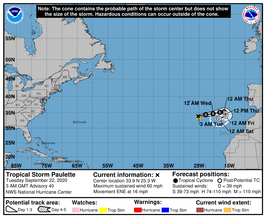
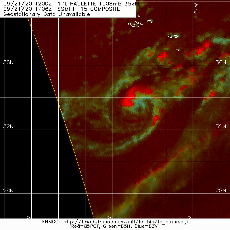
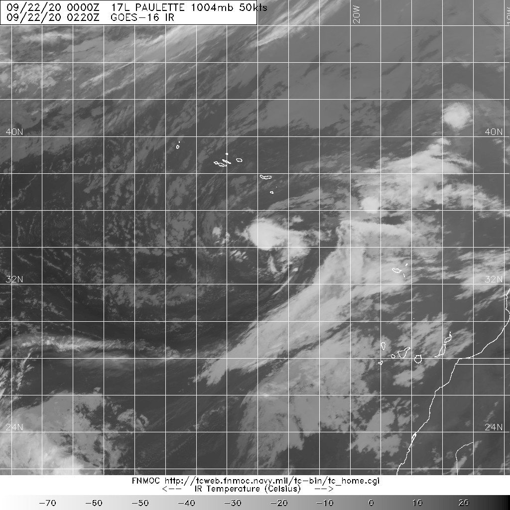
023748_5day_cone_with_line_and_wind.png 20200922.0220.goes-16.ir.17L.PAULETTE.50kts.1004mb.33.6N.26.2W.100pc.jpg
20200921.1706.f15.85rgb.17L.PAULETTE.35kts.1008mb.32.9N.29.8W.075pc.jpg

回復

使用道具 舉報

簽到天數: 1650 天

[LV.Master]伴壇終老

老農民版夜神月|2020-9-23 05:18 | 顯示全部樓層
已減弱至TS下限,即將退化為殘餘低氣壓
AL, 17, 2020092218,   , BEST,   0, 347N,  218W,  35, 1006, TS,  34, NEQ,    0,   50,   50,    0, 1014,  160,  30,  45,   0,   L,   0,    ,   0,   0,   PAULETTE, M, 12, NEQ,   30,   60,  120,    0, genesis-num, 035,
000
WTNT41 KNHC 222050
TCDAT1

Tropical Storm Paulette Discussion Number  43
NWS National Hurricane Center Miami FL       AL172020
900 PM GMT Tue Sep 22 2020

Although Paulette lacks the typical definition for deep convection,
there remains some convection with cloud tops to -20 deg C
encircling an eye-like feature noted in the lower cloud layer. Given
the low tropopause level across that portion of the Atlantic basin
causing the relatively low cloud tops, Paulette is being maintained
as a tropical cyclone for at least this cycle. Vertical wind shear
near 30 kt along with sea-surface temperatures of 23-22 deg C are
expected to result in a gradual weakening and spin down of
Paulette's circulation throughout the forecast period. As a result,
the small cyclone should become a remnant low on Wednesday and
dissipate by Friday or Saturday when the shallow system will be
moving westward into westerly mid-level shear.

Paulette is moving eastward or 080/10 kt. This general motion is
forecast to continue through Wednesday as Paulette remains embedded
within deep-layer westerly flow on the east side of mid- to
upper-level trough. As Paulette weakens and becomes more vertically
shallow, the post-tropical cyclone is expected to slow down in the
36-48 time period and turn southward. Thereafter, Paulette should be
steered westward by low-level easterly flow on the south side of
the Bermuda-Azores High. The new NHC track forecast is similar to
the previous advisory track, and essentially lies down the middle
of the NHC track guidance models.


FORECAST POSITIONS AND MAX WINDS

INIT  22/2100Z 34.8N  21.2W   35 KT  40 MPH
12H  23/0600Z 35.0N  19.4W   30 KT  35 MPH...POST-TROP/REMNT LOW
24H  23/1800Z 35.4N  17.5W   30 KT  35 MPH...POST-TROP/REMNT LOW
36H  24/0600Z 35.3N  16.4W   25 KT  30 MPH...POST-TROP/REMNT LOW
48H  24/1800Z 34.7N  16.7W   25 KT  30 MPH...POST-TROP/REMNT LOW
60H  25/0600Z 33.6N  19.0W   25 KT  30 MPH...POST-TROP/REMNT LOW
72H  25/1800Z 32.8N  22.4W   25 KT  30 MPH...POST-TROP/REMNT LOW
96H  26/1800Z...DISSIPATED

$$
Forecaster Stewart
205114_5day_cone_with_line_and_wind.png 20200922.1820.goes-16.vis.2km.17L.PAULETTE.35kts.1006mb.34.7N.21.8W.pc.jpg
20200922.1440.gpm.89pct89h89v.17L.PAULETTE.45kts.1004mb.34.9N.23W.060pc.jpg
回復

使用道具 舉報

簽到天數: 53 天

[LV.5]常住居民I

天篷大元帥|2020-9-23 15:26 | 顯示全部樓層
GG
原文:
000
WTNT41 KNHC 230236
TCDAT1

Post-Tropical Cyclone Paulette Discussion Number  44
NWS National Hurricane Center Miami FL       AL172020
300 AM GMT Wed Sep 23 2020

Paulette has been devoid of deep convection since early Tuesday,
and the shallow convection mentioned in the previous advisory has
also waned.  Therefore, Paulette has again become a post-tropical
cyclone, and this is the last NHC advisory on this system.  Recent
ASCAT data showed that the system still had a small area of 35 kt
winds so the initial intensity is held at that value.  The
post-tropical cyclone will be moving over waters of 22-23 degrees
Celsius and remain within an area of moderate vertical wind
shear.  This should result in gradual weakening over the next
couple of days.

The post-tropical cyclone continues to move eastward or 080/10 kt.
This motion is forecast to continue through midday Wednesday, but a
reduction is forward speed is expected by Wednesday night as the
system becomes vertically shallow.  The remnant low is expected to
turn southward in 24-36 hours, with a faster west-southwestward
motion anticipated later in the forecast period when it becomes
embedded within the low-level northeasterly flow.

This is the last NHC advisory on Paulette.  Additional information
on this system can be found in High Seas Forecasts issued by Meteo
France under WMO header FQNT50 LFPW and available on the web at
www.meteofrance.com/previsions-meteo-marine/bulletin/grandlarge/
metarea2.


FORECAST POSITIONS AND MAX WINDS

INIT  23/0300Z 34.8N  20.0W   35 KT  40 MPH...POST-TROPICAL
12H  23/1200Z 35.2N  18.3W   30 KT  35 MPH...POST-TROP/REMNT LOW
24H  24/0000Z 35.4N  17.2W   30 KT  35 MPH...POST-TROP/REMNT LOW
36H  24/1200Z 35.1N  17.2W   25 KT  30 MPH...POST-TROP/REMNT LOW
48H  25/0000Z 34.0N  19.1W   25 KT  30 MPH...POST-TROP/REMNT LOW
60H  25/1200Z 33.0N  21.7W   25 KT  30 MPH...POST-TROP/REMNT LOW
72H  26/0000Z 32.5N  26.0W   25 KT  30 MPH...POST-TROP/REMNT LOW
96H  27/0000Z...DISSIPATED

$$
Forecaster Brown

僅供參考的機器翻譯:
000
WTNT41 KNHC 230236
TCDAT1

後熱帶氣旋寶萊特討論編號44
新創建國家颶風中心邁阿密FL AL172020
格林尼治標準時間300 AM 2020年9月23日星期三

自周二初以來,保萊特(Paulette)一直沒有進行強對流,
並且先前諮詢中提到的淺對流有
也減弱了。因此,保萊特再次成為後熱帶
氣旋,這是該系統上的最新NHC諮詢。最近
ASCAT數據顯示,該系統的面積仍為35 kt
纏繞,使初始強度保持在該值。的
後熱帶氣旋將在22-23度的水域上移動
攝氏溫度並保持在垂直風向范圍內
剪。這將導致下一次逐漸減弱
幾天

後熱帶氣旋繼續向東移動或080/10 kt。
預計該議案將持續到星期三中午,但
預計到週三晚上將降低前進速度,因為
系統變得垂直淺。預計殘留量低
在24-36小時內向南轉,西南方向更快
成為預測期之後的運動
嵌入在低水平的東北氣流中。

這是有關Paulette的最新NHC諮詢。附加信息
有關此系統的信息,請參見Meteo發布的公海預報
法國,網址為WMO標頭FQNT50 LFPW,網址為:
www.meteofrance.com/previsions-meteo-marine/bulletin/grandlarge/
metarea2。


預測位置和最大風

INIT 23 / 0300Z 34.8N 20.0W 35 KT 40 MPH ...熱帶
12H 23 / 1200Z 35.2N 18.3W 30 KT 35 MPH ...
24H 24 / 0000Z 35.4N 17.2W 30 KT 35 MPH ...
36H 24 / 1200Z 35.1N 17.2W 25 KT 30 MPH ...
48H 25 / 0000Z 34.0N 19.1W 25 KT 30 MPH ...
60H 25 / 1200Z 33.0N 21.7W 25 KT 30 MPH ...
72H 26 / 0000Z 32.5N 26.0W 25 KT 30 MPH ...
96H 27 / 0000Z ...已分發

$$
預報員布朗

回復

使用道具 舉報

簽到天數: 1650 天

[LV.Master]伴壇終老

老農民版夜神月|2020-9-24 02:54 | 顯示全部樓層
NHC12Z再度提升定強至45KT,但判定性質為LO,亦不再展望能再次發展
已編擾二十日的17L.Paulette或已將行至終點
AL, 17, 2020092312, , BEST, 0, 356N, 181W, 45, 1001, LO, 34, NEQ, 30, 40, 40, 40, 1013, 160, 20, 0, 0, L, 0, , 0, 0, PAULETTE, M, 0, , 0, 0, 0, 0, genesis-num, 035,

20200923.1420.gw1.89pct89h89v.17L.PAULETTE.45kts.1001mb.35.4N.18.1W.97pc.jpg 20200923.1820.goes-16.ir.17L.PAULETTE.45kts.1001mb.36.2N.17.2W.100pc.jpg
17L_gefs_latest.png
回復

使用道具 舉報

簽到天數: 1650 天

[LV.Master]伴壇終老

老農民版夜神月|2020-9-28 01:23 | 顯示全部樓層
不死的17LPaulette,FNMOC再次複編
NHC亦再度開始對17L.Pauiette殘餘發出展望,但暫不看好其能第三度發展
1. The remnants of Paulette, located about 100 miles south of the
Azores, are producing a few disorganized showers. Upper-level winds
are expected to increase later today and no further development is
anticipated.
* Formation chance through 48 hours...low...near 0 percent.
* Formation chance through 5 days...low...near 0 percent.

two_atl_2d1.png 20200927.1540.goes-16.vis.2km.17L.PAULETTE.25kts.1017mb.37.1N.28.3W.pc.jpg
20200927.0551.f15.37h.17L.PAULETTE.25kts.1017mb.37.1N.28.3W.070pc.jpg 20200927.0551.f15.85rgb.17L.PAULETTE.25kts.1017mb.37.1N.28.3W.070pc.jpg
回復

使用道具 舉報

123
快速回覆
您需要登錄後才可以回帖 登錄 | 立即加入

本版積分規則

本平台僅供學術討論之用,預報應以氣象局為準

威普網站虛擬主機贊助公司

臺灣第一個天氣類型社群平台 即時天氣資訊、精準颱風動態

線上客服
FB傳送訊息
廣告行銷
精準行銷 物超所值
官方粉專
發佈 快速回復 返回頂部 返回列表