開啟輔助訪問
 找回密碼
 立即加入

16L.Nana 牙買加近岸實測命名 貝里斯近岸升格C1後登陸

簽到天數: 1650 天

[LV.Master]伴壇終老

老農民版夜神月|2020-9-3 17:22 | 顯示全部樓層
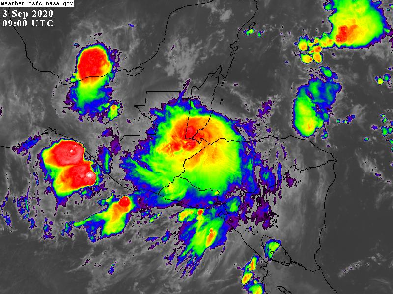
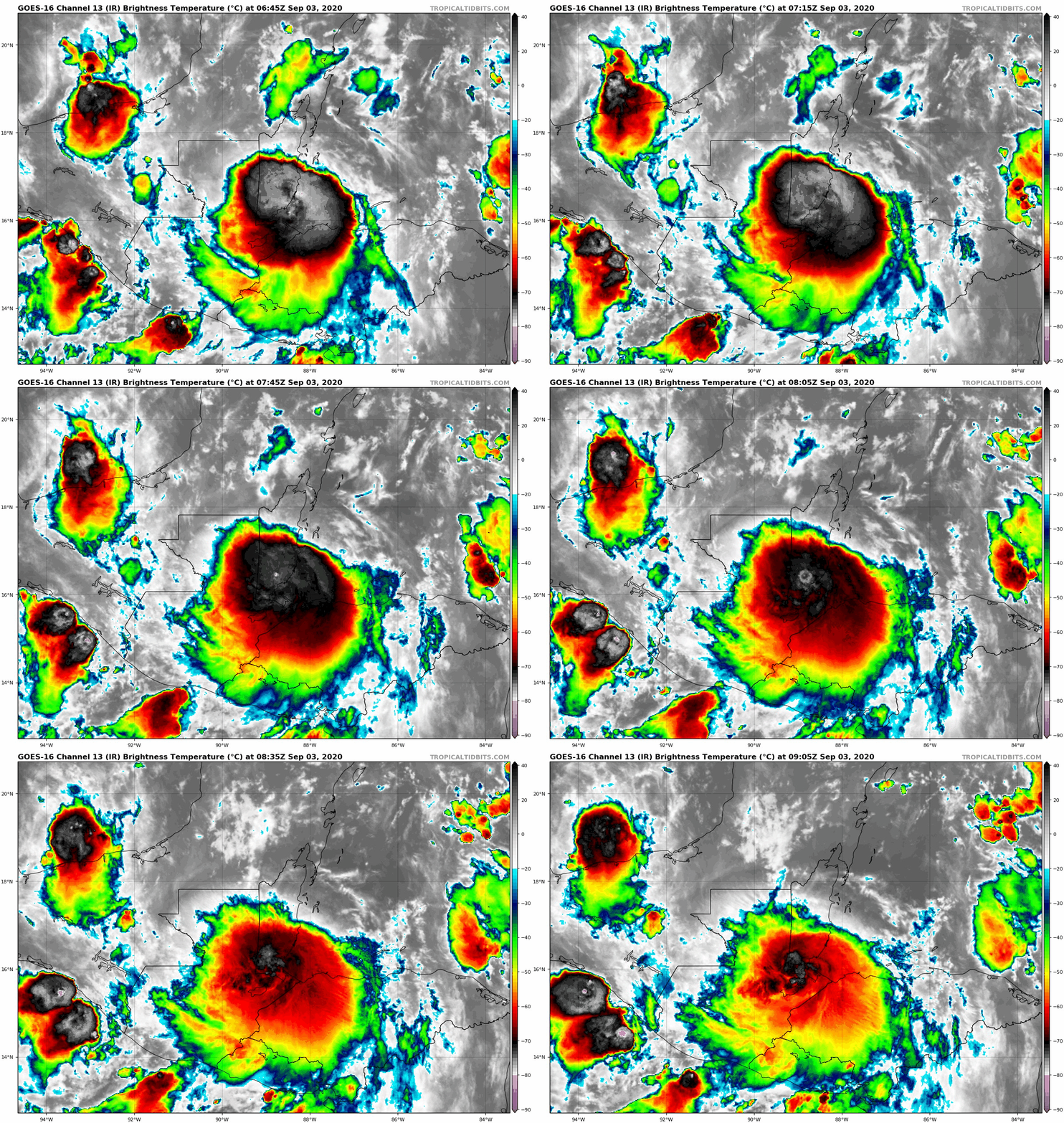
Nana已於06Z登陸貝里斯貝里斯市附近,NHC在報文中暫不看好其跨洋進入東太平洋後的發展
457
WTNT41 KNHC 030844
TCDAT1

Tropical Storm Nana Discussion Number   9
NWS National Hurricane Center Miami FL       AL162020
400 AM CDT Thu Sep 03 2020

Nana made landfall on the coast of Belize about 45 n mi south of
Belize City around 0600 UTC today.  It is estimated to be located
inland and weakening over the southern part of that country with
maximum winds of no more than 60 kt at this time.  The small
circulation will be moving over mountainous terrain today and
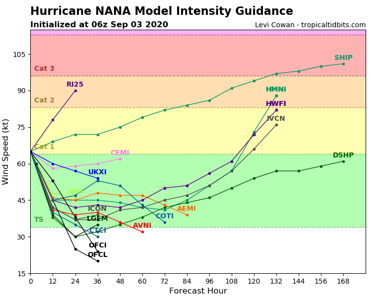
tonight, so rapid weakening is likely.  The official forecast is
similar to the Decay-SHIPS intensity guidance, and calls for the
system to degenerate into a remnant low by Friday.  Although the
remnants of Nana are forecast to move into the east Pacific in about
36 hours, the model guidance is in good agreement that conditions
in that area will not be conducive for regeneration.

The tropical cyclone continues to move a little south of west, or
around 255/13 kt.  A low- to mid-level ridge to the north of Nana
should keep it moving on a west to west-southwestward track during
the next day or so.  The NHC track forecast is similar to the
previous one, and on the northern side of the guidance envelope.


KEY MESSAGES:

1. Tropical storm conditions will continue within the warning areas
in Belize, Mexico, Guatemala, and the Bay Islands of Honduras this
morning.  Storm surge along the Belize coast will subside this
morning as Nana moves farther inland.

2. Heavy rainfall with isolated maximum amounts as high as 8 to 12
inches could result in flash flooding in Belize, Guatemala, and
portions of southeastern Mexico and the Yucatan Peninsula.

FORECAST POSITIONS AND MAX WINDS

INIT  03/0900Z 16.7N  88.8W   60 KT  70 MPH...INLAND
12H  03/1800Z 16.4N  90.7W   45 KT  50 MPH...INLAND
24H  04/0600Z 15.8N  93.0W   25 KT  30 MPH...INLAND
36H  04/1800Z 15.3N  95.2W   20 KT  25 MPH...POST-TROP/REMNT LOW
48H  05/0600Z...DISSIPATED

$$
Forecaster Pasch
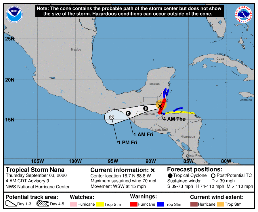
084903_5day_cone_no_line_and_wind.png GOES09002020247j2Dt8B.jpg
16L_intensity_latest.png goes16_ir_16L_202009030645.gif
回復

使用道具 舉報

簽到天數: 601 天

[LV.9]以壇為家II

霧峰追風者|2020-9-4 08:48 | 顯示全部樓層
稍早已殘餘已進入東太,NHC 展望10%。
16L NANA 200904 0000  15.8N   91.4W ATL    25  1007
1. The remnants of Atlantic basin Tropical Depression Nana are
expected to emerge over the eastern Pacific waters near the
Gulf of Tehuantepec late tonight or early Friday.  Unfavorable
upper-level winds are expected to inhibit significant development
through early next week while the system moves generally
west-northwestward, near or along the southern coast of Mexico.
* Formation chance through 48 hours...low...10 percent.
* Formation chance through 5 days...low...20 percent.
two_pac_2d1 (1).png 20200904.0020.goes-17.ir.16L.NANA.25kts.1007mb.15.8N.91.4W.100pc.jpg
回復

使用道具 舉報

簽到天數: 1650 天

[LV.Master]伴壇終老

老農民版夜神月|2020-9-4 15:33 | 顯示全部樓層
NHC03Z判定已成為殘餘低氣壓
000
WTNT41 KNHC 040240
TCDAT1

Remnants Of Nana Discussion Number  12
NWS National Hurricane Center Miami FL       AL162020
1000 PM CDT Thu Sep 03 2020

Satellite and surface data indicate that Nana's low-level
circulation has dissipated over the mountainous terrain of
southwestern Guatemala.  Therefore, this will be the final NHC
advisory on this system.  The mid-level remnants are expected to
emerge over the eastern Pacific waters near the Gulf of Tehuantepec
later tonight or early Friday.  The global models indicate that
strong upper-level northeasterly flow will prevent re-development
over the next couple of days.  However, this system could produce
locally heavy rainfall along portions of the southeastern and
southern coasts of Mexico over the weekend.  Additional information
on the remnants on Nana can be found in the eastern Pacific basin
Tropical Weather Outlook. This product can be found under AWIPS
header MIATWOEP, WMO header ABPZ20 KNHC, and on the web at
www.nhc.noaa.gov/text/refresh/MIATWOEP+shtml/


FORECAST POSITIONS AND MAX WINDS

INIT  04/0300Z 15.6N  92.0W   25 KT  30 MPH
12H  04/1200Z...DISSIPATED

$$
Forecaster Brown
al162020.20200904031711.gif 20200904.0700.goes-17.ir.16L.NANA.25kts.1007mb.15.8N.91.4W.100pc.jpg goes16_ir_16L_202009040455.gif
回復

使用道具 舉報

12
快速回覆
您需要登錄後才可以回帖 登錄 | 立即加入

本版積分規則

本平台僅供學術討論之用,預報應以氣象局為準

威普網站虛擬主機贊助公司

臺灣第一個天氣類型社群平台 即時天氣資訊、精準颱風動態

線上客服
FB傳送訊息
廣告行銷
精準行銷 物超所值
官方粉專
發佈 快速回復 返回頂部 返回列表