開啟輔助訪問
 找回密碼
 立即加入

14E.Iselle 環境轉差 逐漸減弱

簽到天數: 601 天

[LV.9]以壇為家II

2020-8-25 20:22 | 顯示全部樓層
  基本資料  
編號    :14 E
擾動編號日期:2020 08 25 19
撤編日期  :2020 08 31 07
99E.INVEST.25kts-1009mb-14.7N-116.7W

20200825.1150.goes-16.ir.99E.INVEST.25kts.1009mb.14.7N.116.7W.100pc.jpg
3. Another small low pressure system has developed several hundred
miles southwest of the southern tip of the Baja California
peninsula. Some gradual development is possible during the next
couple of days while the system moves slowly east-northeastward.  
* Formation chance through 48 hours...low...20 percent.
* Formation chance through 5 days...low...30 percent.

two_pac_2d3.png

巔峰強度:50KT/997hPa

評分

參與人數 1水氣能量 +15 +1 收起 理由
t02436 + 15 + 1

查看全部評分

回復

使用道具 舉報

簽到天數: 601 天

[LV.9]以壇為家II

霧峰追風者|2020-8-26 07:12 | 顯示全部樓層
本帖最後由 周子堯@FB 於 2020-8-26 07:22 編輯
3. Another low pressure system is located several hundred miles
southwest of the southern tip of the Baja California peninsula.  
Gradual development of this system is possible during the next
couple of days, and a tropical depression could form while it moves
slowly east-northeastward.  
* Formation chance through 48 hours...medium...40 percent.
* Formation chance through 5 days...medium...60 percent

two_pac_2d3.png two_pac_2d3.png
回復

使用道具 舉報

簽到天數: 2141 天

[LV.Master]伴壇終老

周子堯@FB|2020-8-26 17:29 | 顯示全部樓層
NHC展望上調至80%/90%,JTWC亦發出TCFA,預估未來會與13E短暫藤源互動
3. Another low pressure system is located about 700 miles southwest of
the southern tip of the Baja California peninsula.  Showers and
thunderstorms are showing some signs of organization, and this
system will likely become a tropical depression during the next
day or two while it moves slowly east-northeastward to
northeastward.
* Formation chance through 48 hours...high...80 percent.
* Formation chance through 5 days...high...90 percent.
two_pac_2d3.png
2. REMARKS: AN AREA OF CONVECTION (INVEST 99E) HAS PERSISTED NEAR
15.1N 117.4W, APPROXIMATELY 422 NM SOUTHWEST OF SOCORRO, MEXICO.
ANIMATED MULTISPECTRAL SATELLITE IMAGERY, ALONG WITH A 260015Z SSMIS
F-16 91GHZ MICROWAVE IMAGE, DEPICTS AN ELONGATED LOW LEVEL
CIRCULATION CENTER (LLCC) WITH FLARING CONVECTION OFFSET TO THE
WEST. INVEST 99E IS CURRENTLY IN A FAVORABLE ENVIRONMENT WITH GOOD
EQUATORWARD OUTFLOW, LOW (<15KTS) VERTICAL WIND SHEAR, AND WARM (28-
29 CELSIUS) SEA SURFACE TEMPERATURES. GLOBAL MODELS ARE IN GOOD
AGREEMENT THAT INVEST 99E WILL TRACK GENERALLY NORTHEASTWARD AND
WILL CONTINUE TO CONSOLIDATE. MAXIMUM SUSTAINED SURFACE WINDS ARE
ESTIMATED AT 20 TO 25 KNOTS. MINIMUM SEA LEVEL PRESSURE IS ESTIMATED
TO BE NEAR 1004 MB. THE POTENTIAL FOR THE DEVELOPMENT OF A
SIGNIFICANT TROPICAL CYCLONE WITHIN THE NEXT 24 HOURS IS HIGH.

ep9920.gif
20200826.0900.goes-16.ir.99E.INVEST.30kts.1004mb.15.4N.117.3W.100pc.jpg


評分

參與人數 1水氣能量 +15 收起 理由
king111807 + 15 TCFA

查看全部評分

回復

使用道具 舉報

簽到天數: 1650 天

[LV.Master]伴壇終老

老農民版夜神月|2020-8-26 22:51 | 顯示全部樓層
NHC升格TD14E,預報將短暫成為TS
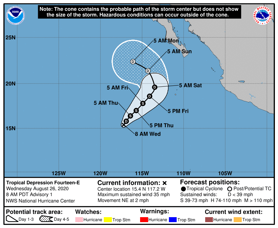
000
WTPZ44 KNHC 261445
TCDEP4

Tropical Depression Fourteen-E Discussion Number   1
NWS National Hurricane Center Miami FL       EP142020
800 AM PDT Wed Aug 26 2020

Earlier scatterometer data and GOES-16 Proxy-VIS satellite
imagery indicate that the area of low pressure located several
hundred miles southwest of the southern tip of the Baja California
peninsula has acquired sufficient convective organization and a
well-defined surface circulation, and is now classified as a
tropical cyclone.  Dvorak satellite intensity estimates and the
aforementioned scatterometer data support an initial wind speed
of 30 kt for this advisory.

Moderate to strong east-northeasterly shear, the same inhibiting
upper wind pattern that is affecting depression Thirteen-E, is
forecast to hamper significant development through the entire
forecast period.  Therefore, only modest strengthening in the
next 24 hours is expected, which agrees with the statistical-
dynamical guidance and the large-scale models.

The depression is moving rather slowly toward the northeast, or
040/2 kt.  The low to mid-level steering synoptic pattern consists
of a cyclonic gyre stretching southwestward from Hurricane Laura
over central Mexico and into the eastern Pacific.  This feature
should cause the depression to continue in a northeastward general
direction at a relatively slow pace through Friday.  Afterward, a
gradual turn toward the north-northwest and west-northwest is
expected as high pressure currently over the southwestern U.S.
builds westward over the Baja California peninsula and adjacent
eastern Pacific.  The NHC official forecast is a reflection of a
blend of the HCCA and TVCE consensus aids.

FORECAST POSITIONS AND MAX WINDS

INIT  26/1500Z 15.4N 117.2W   30 KT  35 MPH
12H  27/0000Z 15.8N 116.9W   30 KT  35 MPH
24H  27/1200Z 16.4N 116.4W   35 KT  40 MPH
36H  28/0000Z 17.0N 115.7W   35 KT  40 MPH
48H  28/1200Z 17.8N 114.9W   35 KT  40 MPH
60H  29/0000Z 18.6N 114.1W   30 KT  35 MPH
72H  29/1200Z 19.6N 113.5W   30 KT  35 MPH
96H  30/1200Z 21.4N 114.3W   30 KT  35 MPH...POST-TROP/REMNT LOW
120H  31/1200Z 22.4N 116.1W   25 KT  30 MPH...POST-TROP/REMNT LOW

$$
Forecaster Roberts

144624_5day_cone_with_line_and_wind.png 20200826.1420.goes-17.ir.99E.INVEST.30kts.1004mb.15.3N.117.3W.100pc.jpg
20200826.0933.gw1.89pct89h89v.99E.INVEST.30kts.1004mb.15.4N.117.3W.95pc.jpg
回復

使用道具 舉報

簽到天數: 601 天

[LV.9]以壇為家II

霧峰追風者|2020-8-27 09:55 | 顯示全部樓層
000
WTPZ44 KNHC 262048
TCDEP4

Tropical Storm Iselle Discussion Number   2
NWS National Hurricane Center Miami FL       EP142020
200 PM PDT Wed Aug 26 2020

A recent ASCAT overpass revealed that the cyclone barely has a
closed center, and is embedded in a northeast-southwest oriented
monsoon gyre feature. However, this same overpass sampled a
decent sized area of 33-34 kt winds over the southeastern quadrant,
and therefore the system has been upgraded to 35 kt Tropical Storm
Iselle.

Assuming that the storm does not get absorbed into the monsoon gyre
and open back into a trough, it should maintain its intensity over
warm waters, while battling 20-30 kt of easterly to northeasterly
shear over the next few days. After that time, the shear persists
but Iselle should begin to move over waters with a lower oceanic
heat content. This should cause the cyclone to weaken and eventually
degenerate into a remnant low late in the forecast period. The
latest NHC intensity forecast is near the various intensity
consensus guidance.

The depression is moving northeast at 4 kt. This motion is expected
to continue for the next day or so as it moves around the cyclonic
gyre stretching southwestward from Hurricane Laura over central
Mexico and into the eastern Pacific. Afterward, a gradual turn
toward the north-northwest and west-northwest is expected as high
pressure currently over the southwestern U.S. builds westward over
the Baja California peninsula and adjacent eastern Pacific. The NHC
forecast track is little changed from the previous one, and lies
near the HFIP corrected consensus, or HCCA.


FORECAST POSITIONS AND MAX WINDS

INIT  26/2100Z 15.5N 116.8W   35 KT  40 MPH
12H  27/0600Z 16.0N 116.3W   35 KT  40 MPH
24H  27/1800Z 16.8N 115.7W   35 KT  40 MPH
36H  28/0600Z 17.3N 115.1W   35 KT  40 MPH
48H  28/1800Z 17.9N 114.4W   35 KT  40 MPH
60H  29/0600Z 18.7N 113.7W   35 KT  40 MPH
72H  29/1800Z 19.9N 113.7W   30 KT  35 MPH
96H  30/1800Z 21.4N 114.9W   30 KT  35 MPH...POST-TROP/REMNT LOW
120H  31/1800Z 22.1N 116.1W   25 KT  30 MPH...POST-TROP/REMNT LOW

$$
Forecaster Latto
204930_5day_cone_no_line_and_wind.png 20200827.0130.goes-17.ir.14E.ISELLE.35kts.1001mb.15.9N.116.4W.100pc.jpg 20200827.0000.f16.ir.olsircomp.14E.FOURTEEN.x.jpg
回復

使用道具 舉報

簽到天數: 1650 天

[LV.Master]伴壇終老

老農民版夜神月|2020-8-29 01:15 | 顯示全部樓層
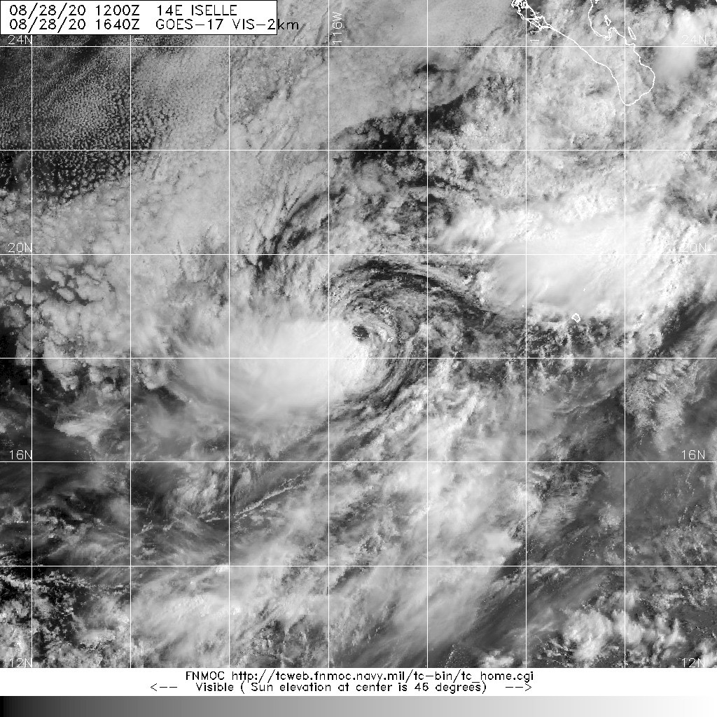
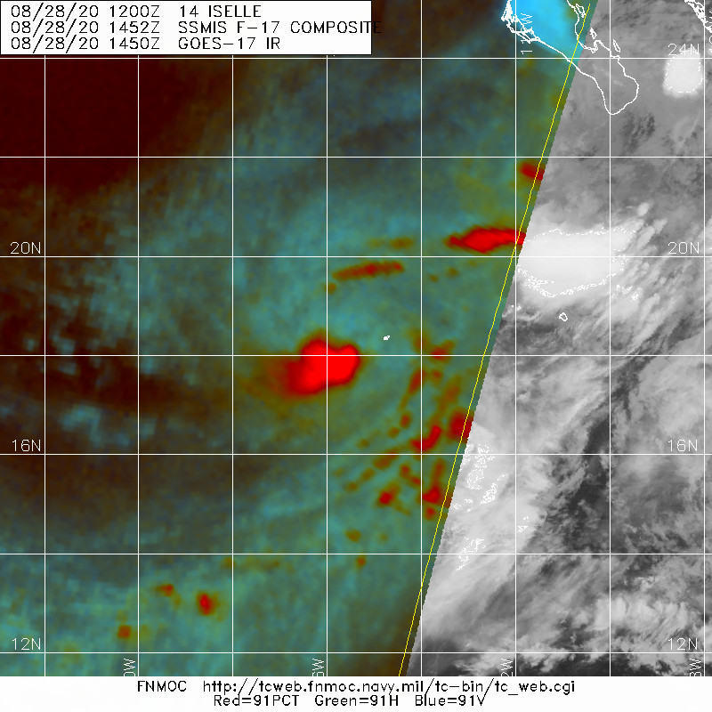
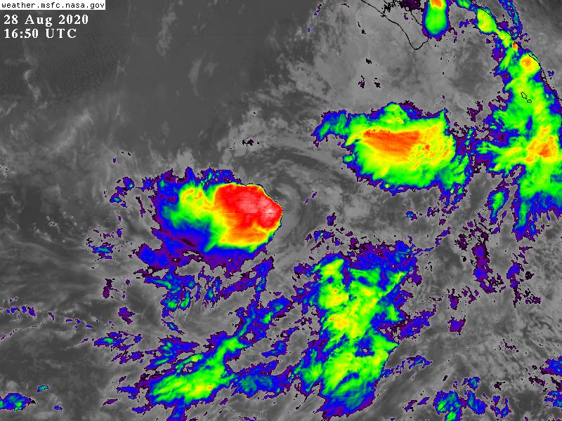
NHC認為目前的14E已接近巔峰,強度將於12H~24H後逐漸減弱
078
WTPZ44 KNHC 281447
TCDEP4

Tropical Storm Iselle Discussion Number   9
NWS National Hurricane Center Miami FL       EP142020
800 AM PDT Fri Aug 28 2020

GOES-16 shortwave infrared imagery and a recent AMSR2 microwave
overpass indicate that deep convection has been developing near the
surface center during the past several hours.  In fact, the
microwave image showed a small, compact inner core defined by a
partially closed eye-like feature.  My initial thoughts were that
this cloud feature is in the mid-portion of the atmosphere, but the
lower 37 GHZ frequency confirmed very little vertical tilt.
Subjective and objective satellite intensity estimates are based on
the shear scene-type which would yield a slightly lower intensity
estimation.  Consequently, the initial intensity is held at 50 kt,
but it could certainly be a little stronger based on the
aforementioned polar low-orbiter pass.

The FV3/GFS and ECMWF SHIPS statistical-dynamical intensity models
show 20 to 30 kt of northeasterly shear persisting through the next
few days, however, the UW-CIMSS shear analysis reveals less than 20
kt.  For now, based on what the large-scale models and the SHIPS
models agree on, gradual weakening should begin by early Saturday
morning and continue through Monday morning as the cyclone
traverses decreasing oceanic temperatures and moves into a more
thermodynamically stable surrounding environment.  The NHC intensity
is an update of the previous advisory, and calls for Iselle
to weaken to a tropical depression on Sunday and degenerate into a
remnant low on Sunday evening.

Based on the 0920 UTC AMSR2 pass, the initial position was adjusted
to the northwest of the previous position and the forward motion is
estimated to be northeastward, or 035/4 kt.  A northward direction
should commence by early Saturday morning, then a turn
north-northwestward to northwestward is forecast during the 48-60
hr period.  As Iselle continues to weaken and become a more
shallower system, a turn toward the west-northwest, well offshore
of the southern coast of the Baja California peninsula, is forecast
to occur Monday morning.  The NHC forecast is nudged to the left of
the previous track forecast due the adjusted position, and is based
on the HCCA and TVCE multi-model consensus aids.


FORECAST POSITIONS AND MAX WINDS

INIT  28/1500Z 18.3N 115.3W   50 KT  60 MPH
12H  29/0000Z 19.2N 114.8W   50 KT  60 MPH
24H  29/1200Z 20.6N 114.6W   45 KT  50 MPH
36H  30/0000Z 22.2N 114.9W   35 KT  40 MPH
48H  30/1200Z 23.5N 115.7W   30 KT  35 MPH
60H  31/0000Z 24.1N 116.6W   25 KT  30 MPH...POST-TROP/REMNT LOW
72H  31/1200Z 24.4N 117.3W   20 KT  25 MPH...POST-TROP/REMNT LOW
96H  01/1200Z...DISSIPATED

$$
Forecaster Roberts
144624_5day_cone_with_line_and_wind.png 20200828.1640.goes-17.vis.2km.14E.ISELLE.50kts.997mb.18N.115.4W.pc.jpg
20200828.1452.f17.composite.14E.ISELLE.50kts.997mb.18N.115.4W.070pc.jpg GOES16502020241Tw7RpW.jpg
回復

使用道具 舉報

簽到天數: 1650 天

[LV.Master]伴壇終老

老農民版夜神月|2020-8-31 02:52 | 顯示全部樓層
持續北行,環境趨於惡劣,即將減弱為殘餘低氣壓
000
WTPZ44 KNHC 301436
TCDEP4

Tropical Depression Iselle Discussion Number  17
NWS National Hurricane Center Miami FL       EP142020
900 AM MDT Sun Aug 30 2020

Iselle is skirting the line between tropical cyclone and remnant
low, producing a small amount of deep convection during the past few
hours. While this isn't particularly organized thunderstorm
activity, for now it is enough to keep advisories going another 6
hours.  The initial intensity is set to 30 kt, near the latest TAFB
T-number.  Iselle is still expected to degenerate into a remnant
low later today due to persistent easterly shear and a dry and
stable environment. Model guidance all show the system becoming a
trough by Tuesday, so the dissipation phase has been pushed ahead
from the last forecast.  The guidance also remains in good agreement
on a northward track today, followed by a north-northwest turn
overnight.  The track is shifted a bit to the east because of a more
eastward initial position, otherwise it is unchanged.


FORECAST POSITIONS AND MAX WINDS

INIT  30/1500Z 23.0N 113.3W   30 KT  35 MPH
12H  31/0000Z 24.0N 113.4W   25 KT  30 MPH...POST-TROP/REMNT LOW
24H  31/1200Z 25.0N 113.7W   20 KT  25 MPH...POST-TROP/REMNT LOW
36H  01/0000Z...DISSIPATED

$$
Forecaster Blake

143656_5day_cone_no_line_and_wind.png 20200830.1800.goes-17.vis.2km.14E.ISELLE.30kts.1006mb.22.7N.113.4W.pc.jpg
20200830.1315.gpm.composite.14E.ISELLE.30kts.1006mb.22.7N.113.4W.045pc.jpg

點評

裸奔中  發表於 2020-8-31 07:16
回復

使用道具 舉報

簽到天數: 53 天

[LV.5]常住居民I

天篷大元帥|2020-8-31 07:16 | 顯示全部樓層
GG
原文:
000
WTPZ44 KNHC 302035
TCDEP4

Post-Tropical Cyclone Iselle Discussion Number  18
NWS National Hurricane Center Miami FL       EP142020
300 PM MDT Sun Aug 30 2020

Iselle hasn't produced organized deep convection for about the past
day, so it no longer meets the definition of a tropical cyclone.  
Thus, it is now a post-tropical remnant low, and this is the last
advisory. The initial wind speed is set to 25 kt, which matches a
recent ASCAT-B pass.  Models are in good agreement on the low
gradually turning from its current northward heading to north-
northwest tomorrow and slowly weakening due to a poor environment.  
The low is expected to degenerate into a trough of low pressure on
Tuesday, and no changes were made from the previous forecast.

FORECAST POSITIONS AND MAX WINDS

INIT  30/2100Z 23.7N 113.3W   25 KT  30 MPH...POST-TROPICAL
12H  31/0600Z 24.7N 113.4W   20 KT  25 MPH...POST-TROP/REMNT LOW
24H  31/1800Z 25.8N 113.8W   20 KT  25 MPH...POST-TROP/REMNT LOW
36H  01/0600Z...DISSIPATED

$$
Forecaster Blake


機器翻譯(粗劣僅供參考):
000
WTPZ44 KNHC 302035
TCDEP4

後熱帶氣旋艾澤爾討論第18號
新創建國家颶風中心邁阿密FL EP142020
MDT MPM 300 2020年8月30日星期日

Iselle過去沒有進行過有組織的深度對流
天,所以它不再符合熱帶氣旋的定義。  
因此,它現在是後熱帶遺蹟的低點,這是最後一個
諮詢。初始風速設置為25 kt,與
最近的ASCAT-B通行證。模型在低點上很好地吻合
從目前的向北方向逐漸轉向北向-
明天西北,並且由於惡劣的環境而逐漸減弱。  
預計低點將退化為低壓的低谷。
週二,與之前的預測沒有任何變化。

預測位置和最大風

INIT 30 / 2100Z 23.7N 113.3W 25 KT 30 MPH ...熱帶
12H 31 / 0600Z 24.7N 113.4W 20 KT 25 MPH ...
24H 31 / 1800Z 25.8N 113.8W 20 KT 25 MPH ...
36H 01 / 0600Z ...已分發

$$
預報員布雷克

回復

使用道具 舉報

快速回覆
您需要登錄後才可以回帖 登錄 | 立即加入

本版積分規則

本平台僅供學術討論之用,預報應以氣象局為準

威普網站虛擬主機贊助公司

臺灣第一個天氣類型社群平台 即時天氣資訊、精準颱風動態

線上客服
FB傳送訊息
廣告行銷
精準行銷 物超所值
官方粉專
發佈 快速回復 返回頂部 返回列表