開啟輔助訪問
 找回密碼
 立即加入

12L.Kyle 加速東北行

簽到天數: 601 天

[LV.9]以壇為家II

2020-8-14 08:05 | 顯示全部樓層
  基本資料  
編號    :12 L
擾動編號日期:2020 08 14 07
撤編日期  :2020 08 17 01
96L.INVEST.15kts-1012mb-38.0N-70.0W

20200813.2330.goes-16.ir.96L.INVEST.15kts.1012mb.38N.70W.100pc.jpg
1. A broad area of low pressure over eastern North Carolina is
forecast to move east-northeastward across the north Atlantic well
to the southeast of New England and to the south of the Canadian
Maritime provinces over the next several days.  This system could
acquire some subtropical or tropical characteristics during the next
few days while it moves over warm sea surface temperatures of the
Gulf Stream.
* Formation chance through 48 hours...low...30 percent.
* Formation chance through 5 days...medium...40 percent.

two_atl_2d1.png

評分

參與人數 1水氣能量 +15 +1 收起 理由
t02436 + 15 + 1

查看全部評分

回復

使用道具 舉報

簽到天數: 3206 天

[LV.Master]伴壇終老

king111807|2020-8-14 21:42 | 顯示全部樓層
NHC提升展望至Medium,40%
1. Shower activity has increased in association with a low pressure
area located about 100 miles northeast of Cape Hatteras, North
Carolina.  Some additional development is possible during the next
couple of days, and a tropical or subtropical depression could form
during that time as the system moves east-northeastward well
to the southeast of New England and to the south of the Canadian
Maritime provinces.
* Formation chance through 48 hours...medium...40 percent.
* Formation chance through 5 days...medium...50 percent.
two_atl_2d1.png

回復

使用道具 舉報

簽到天數: 1650 天

[LV.Master]伴壇終老

老農民版夜神月|2020-8-15 02:48 | 顯示全部樓層
FWC-N發布TCFA;NHC提升展望至High,70%
WTNT21 KNGU 141700
SUBJ/TROPICAL CYCLONE FORMATION ALERT//
RMKS/1. FORMATION OF A SIGNIFICANT TROPICAL STORM IS POSSIBLE
WITHIN 100 NM EITHER SIDE OF A LINE FROM 36.6N 74.7W TO 39.3N 66.0W
WITHIN THE NEXT 24 HOURS. AVAILABLE DATA DOES NOT JUSTIFY
ISSUANCE OF NUMBERED TROPICAL CYCLONE WARNINGS AT THIS TIME.
WINDS IN THE AREA ARE ESTIMATED TO BE 30 TO 35 KNOTS. METSAT
IMAGERY AT 141200Z INDICATES THAT A CIRCULATION CENTER IS LOCATED
NEAR 36.6N 74.4W. THE SYSTEM IS MOVING EAST-NORTHEASTWARD AT 18
KNOTS.
2.SHOWERS AND THUNDERSTORMS ASSOCIATED WITH A LOW PRESSURE SYSTEM
LOCATED ABOUT 130 MILES EAST OF THE DELMARVA PENINSULA CONTINUE TO
BECOME BETTER ORGANIZED. FURTHER DEVELOPMENT IS POSSIBLE AND A
TROPICAL OR SUBTROPICAL DEPRESSION OR STORM COULD FORM DURING THE
NEXT 24 HOURS AS IT MOVES EAST-NORTHEASTWARD AWAY FROM THE COAST
OF NEW ENGLAND.
3. THIS ALERT WILL BE REISSUED, UPGRADED TO WARNING OR CANCELLED
BY 151700Z.//
1. Satellite imagery indicates that shower activity associated with the
low pressure area located about 300 miles south-southwest of
Nantucket, Massachusetts has become better organized.  In addition,
recent satellite wind data show that the circulation is becoming
better defined, with winds to near gale force to the southeast of
the center.  If current trends continue, a tropical depression or
tropical storm is likely to form later today or tonight.  Regardless
of development, this system is expected to move east-northeastward
well to the southeast of New England and to the south of the
Canadian Maritime provinces.  Additional information can be found in
High Sea High Seas Forecasts issued by the National Weather Service
under AWIPS header NFDHSFAT1, WMO header FZNT01 KWBC, and online at
ocean.weather.gov/shtml/NFDHSFAT1.php
* Formation chance through 48 hours...high...70 percent.
* Formation chance through 5 days...high...70 percent.

al962020.gif two_atl_2d1.png
20200814.1810.goes-16.vis.2km.96L.INVEST.30kts.1008mb.37.4N.72.6W.pc.jpg LATEST.jpg

評分

參與人數 1水氣能量 +15 收起 理由
king111807 + 15 TCFA

查看全部評分

回復

使用道具 舉報

簽到天數: 1650 天

[LV.Master]伴壇終老

老農民版夜神月|2020-8-15 05:30 | 顯示全部樓層
NHC21Z升格12L,命名Kyle,上望45KT
WTNT42 KNHC 142041
TCDAT2

Tropical Storm Kyle Discussion Number   1
NWS National Hurricane Center Miami FL       AL122020
500 PM EDT Fri Aug 14 2020

Earlier this afternoon, one-minute visible satellite imagery
clearly showed that an area of low pressure off the mid-Atlantic
coast of the U.S. had developed a well defined center. Banding
convection wraps from the northeast to the southeast quadrant of
the cyclone, and a combination of surface obs, ship reports, and
buoy data all indicate that the system is not frontal. Although its
organization is limited by strong southwesterly upper-level winds,
the convection appears to be sufficiently well organized to
classify the system as a tropical cyclone. Earlier ASCAT data
indicated that the maximum winds were between 30 and 35 kt, so the
initial intensity is set at 35 kt, assuming some slight
undersampling may have occurred. Kyle is the earliest 11th named
storm on record for the Atlantic basin. The previous record was
Katrina, which became a tropical storm on August 24, 2005.

Kyle is moving quickly east-northeastward along the northern portion
of the Gulf Stream, and its future as a tropical cyclone is likely
tied to how long it remains over those warm waters. A mid-latitude
trough will continue to steer the system generally
east-northeastward for the next few days, with some increase in
forward speed. This will cause the storm to move quickly
northeastward away from the U.S. coast and well south of the
Canadian Maritimes.

As long as the tropical cyclone remains over warm waters, some
strengthening is possible, and this is reflected in all of the
intensity guidance. That said, strong upper-level winds will likely
keep the system sufficiently sheared to prevent significant tropical
strengthening. Extratropical transition is forecast to begin within
48 h, and should be complete by 60 h. Sometime around or just after
72 h, the low is forecast to either merge with or be absorbed by a
larger extratropical low pressure system over the North Atlantic.
The NHC intensity forecast is based on the multi-model consensus,
with a little extra weight given to the global models for the
extratropical phase.


FORECAST POSITIONS AND MAX WINDS

INIT  14/2100Z 37.7N  71.7W   35 KT  40 MPH
12H  15/0600Z 38.7N  69.0W   40 KT  45 MPH
24H  15/1800Z 40.0N  64.6W   45 KT  50 MPH
36H  16/0600Z 41.4N  60.2W   45 KT  50 MPH
48H  16/1800Z 42.4N  56.0W   45 KT  50 MPH
60H  17/0600Z 43.1N  51.5W   45 KT  50 MPH...POST-TROP/EXTRATROP
72H  17/1800Z 43.1N  46.0W   40 KT  45 MPH...POST-TROP/EXTRATROP
96H  18/1800Z...DISSIPATED

$$
Forecaster Zelinsky
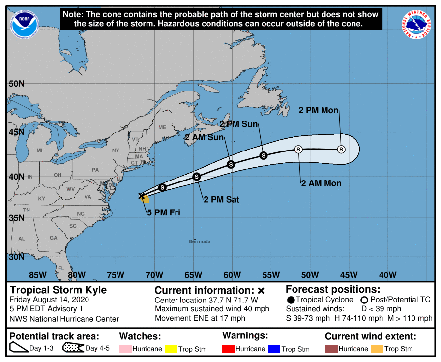
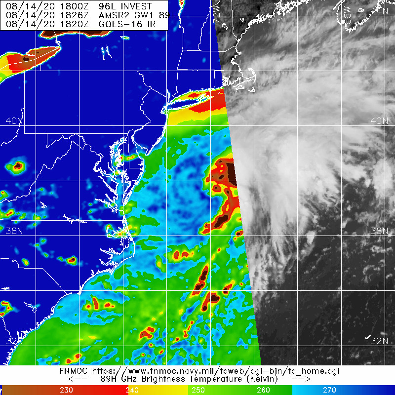
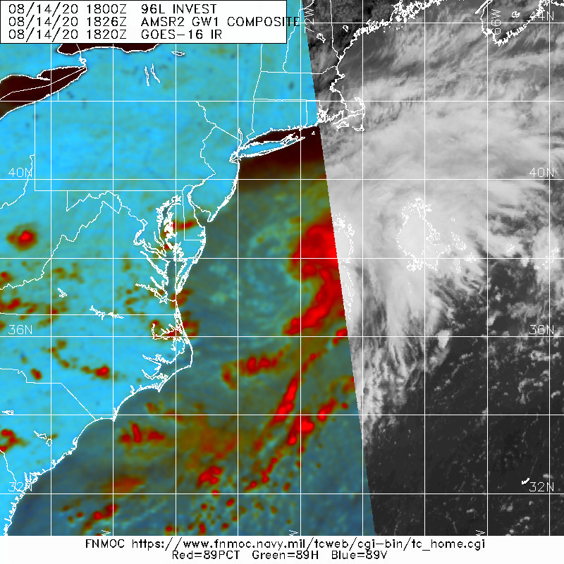
205641_5day_cone_with_line_and_wind.png 20200814.1826.gw1.89hw.96L.INVEST.30kts.1008mb.37.4N.72.6W.61pc.jpg
20200814.1826.gw1.89pct89h89v.96L.INVEST.30kts.1008mb.37.4N.72.6W.61pc.jpg
回復

使用道具 舉報

簽到天數: 3291 天

[LV.Master]伴壇終老

t02436|2020-8-16 17:30 | 顯示全部樓層
已轉化為後熱帶氣旋
000
WTNT42 KNHC 160847
TCDAT2

Post-Tropical Cyclone Kyle Discussion Number   7
NWS National Hurricane Center Miami FL       AL122020
500 AM AST Sun Aug 16 2020

Shortwave infrared satellite imagery and earlier ASCAT data
indicate that Kyle's circulation has become very elongated, and the
center has become ill defined.  Model analyses and satellite imagery
also suggest that the low is now attached to a prominent
warm/stationary front to its east and a weaker trailing cold front
to its southwest.  Therefore, Kyle has become an extratropical low,
and its maximum winds are estimated to be 35 kt based on the earlier
ASCAT data.  Global models indicate that Kyle's winds should
continue to decrease over the next couple of days, with the system
dissipating or becoming absorbed by another area of low pressure in
about 48 hours.

The initial motion is eastward, or 080/17 kt.  Since Kyle is
embedded in zonal mid-latitude flow, this general heading and speed
are expected to continue during the next day or two until the
cyclone dissipates.


FORECAST POSITIONS AND MAX WINDS

INIT  16/0900Z 40.0N  58.9W   35 KT  40 MPH...POST-TROP/EXTRATROP
12H  16/1800Z 40.4N  55.7W   35 KT  40 MPH...POST-TROP/EXTRATROP
24H  17/0600Z 40.4N  51.8W   30 KT  35 MPH...POST-TROP/EXTRATROP
36H  17/1800Z 39.9N  47.5W   30 KT  35 MPH...POST-TROP/EXTRATROP
48H  18/0600Z...DISSIPATED

$$
Forecaster Berg

084802_5day_cone_with_line.png

GOES091020202291Y11IR.jpg
回復

使用道具 舉報

快速回覆
您需要登錄後才可以回帖 登錄 | 立即加入

本版積分規則

本平台僅供學術討論之用,預報應以氣象局為準

威普網站虛擬主機贊助公司

臺灣第一個天氣類型社群平台 即時天氣資訊、精準颱風動態

線上客服
FB傳送訊息
廣告行銷
精準行銷 物超所值
官方粉專
發佈 快速回復 返回頂部 返回列表