開啟輔助訪問
 找回密碼
 立即加入

08L.Hanna 近岸爆發 登陸德州南部

簽到天數: 1650 天

[LV.Master]伴壇終老

2020-7-22 04:14 | 顯示全部樓層
本帖最後由 老農民版夜神月 於 2020-7-26 08:23 編輯

  基本資料  
編號    :91 L
擾動編號日期:2020 07 22 02
撤編日期  :2020 07 00 00
91L INVEST 200721 1800 25.2N 84.7W ATL 25 1014

035044rwfcdvdj7d3gfjuu.jpg

  NHC:30%
1. A tropical wave is producing a large area of disorganized showers
and thunderstorms over western Cuba, the northwestern Bahamas,
southern Florida, and the adjacent waters of the Atlantic,
Caribbean Sea, and the Gulf of Mexico.  Gradual development of this
system is possible while it moves west-northwestward during the
next few days.  This system is expected to cross the southeastern
Gulf of Mexico this afternoon and tonight, move over the central
Gulf on Wednesday, and reach the northwestern Gulf on Thursday and
Friday.  An Air Force Reserve Hurricane Hunter aircraft is
scheduled to investigate the system on Wednesday, if necessary.
* Formation chance through 48 hours...low...30 percent.
* Formation chance through 5 days...medium...40 percent.

two_atl_2d1 (2).png two_atl_5d1 (2).png


評分

參與人數 1水氣能量 +15 +1 收起 理由
king111807 + 15 + 1 熱帶擾動首帖

查看全部評分

回復

使用道具 舉報

簽到天數: 1650 天

[LV.Master]伴壇終老

老農民版夜神月|2020-7-22 22:28 | 顯示全部樓層
評級提升至Medium,40%/50%
1. A tropical wave is producing a large area of disorganized showers
and thunderstorms over the eastern Gulf of Mexico, central
and southern Florida, and western Cuba.  Gradual development of
this system is possible while it moves west-northwestward, and a
tropical depression could form during the next few days.   This
disturbance is expected to move over the central Gulf today, and
reach the northwestern Gulf on Thursday and Friday.  An Air Force
Reserve Hurricane Hunter aircraft is scheduled to investigate the
system later today, if necessary.
* Formation chance through 48 hours...medium...40 percent.
* Formation chance through 5 days...medium...50 percent.

two_atl_2d1.png two_atl_5d1.png
91L_gefs_latest.png
回復

使用道具 舉報

簽到天數: 1650 天

[LV.Master]伴壇終老

老農民版夜神月|2020-7-23 02:18 | 顯示全部樓層
FWC-N於22/1700Z發布TCFA
WTNT21 KNGU 221700
SUBJ/TROPICAL CYCLONE FORMATION ALERT//
RMKS/1.FORMATION OF A SIGNIFICANT TROPICAL CYCLONE IS POSSIBLE
WITHIN 100 NM EITHER SIDE OF A LINE FROM 25.8N 87.9W TO 26.6N 92.5W
WITHIN THE NEXT 12 TO 24 HOURS. AVAILABLE DATA DOES NOT JUSTIFY
ISSUANCE OF NUMBERED TROPICAL CYCLONE WARNINGS AT THIS TIME.
WINDS IN THE AREA ARE ESTIMATED TO BE 20 TO 25 KNOTS. METSAT
IMAGERY AT 221200Z INDICATES THAT A CIRCULATION CENTER IS LOCATED
NEAR 25.7N 87.9W. THE SYSTEM IS MOVING WEST-NORTHWESTWARD AT 10
KNOTS.
2.AN AREA OF LOW PRESSURE HAS FORMED OVER THE CENTRAL GULF OF
MEXICO WELL SOUTH SOUTHEAST OF THE COAST OF LOUISANA. SHOWERS
AND THUNDERSTORMS ASSOCIATED WITH THE SYSTEM HAVE BECOME BETTER
ORGANIZED THIS MORNING AND MORE CONCENTRATED NEAR WHERE A SURFACE
CENTER OF CIRCULATION MAY BE FORMING. FURTHER DEVELOPMENT OF THE
LOW IS POSSIBLE AS IT MOVES INTO THE WESTERN GULF THURSDAY AND A
TROPICAL DEPRESSION IS LIKELY TO FORM AT THAT TIME OR ON FRIDAY.
3.THIS ALERT WILL BE REISSUED, UPGRADED TO A WARNING OR CANCELLED
BY 231700Z.//

015920paqrfllrkq4y2uaz.gif two_atl_2d1.png
GOES180620202041wRQtL.jpg 001543wx6hayxornnunyoy.jpg
回復

使用道具 舉報

簽到天數: 601 天

[LV.9]以壇為家II

霧峰追風者|2020-7-23 12:05 | 顯示全部樓層
000
WTNT43 KNHC 230242
TCDAT3

Tropical Depression Eight Discussion Number   1
NWS National Hurricane Center Miami FL       AL082020
1000 PM CDT Wed Jul 22 2020

Surface observations and data from the Air Force Hurricane Hunters
indicate that the area of low pressure over the central Gulf of
Mexico has developed a closed circulation and a well-defined
center.  In addition, recent satellite images show an area of deep
convection expanding over the center.  Based on those observations,
advisories are being initiated on Tropical Depression Eight.  The
initial intensity is set at 25 kt based on the earlier
reconnaissance data.

The initial motion is an uncertain west-northwestward at 5 kt.  A
subtropical ridge to the northeast of the depression should cause
it to continue moving in that general direction through Friday as
it tracks across the northwestern Gulf of Mexico.  A slight turn to
the left is expected Friday night and Saturday as a ridge builds to
the north of the system, taking the center of cyclone across the
Texas coast and then inland over southern Texas.  The models are in
fairly good agreement on this scenario, and the NHC track forecast
lies near the various consensus models.

The depression is expected to be in generally light to moderate
wind shear conditions, in a fairly moist environment, and over the
warm waters of the Gulf of Mexico for the next couple of days, so
some strengthening seems likely. However, since the depression is
still in its formative stage, the rate of strengthening should be
gradual.  After the storm crosses the coast, steady weakening should
commence.  The NHC intensity forecast generally follows the IVCN and
HCCA guidance.

Key Messages

1. The depression is expected to strengthen and it could bring
tropical-storm-force winds to portions of the Texas coast, where a
tropical storm watch has been issued.

2. The depression is expected to produce heavy rains across
portions of Louisiana and southern Texas.  These rains could result
in flash flooding.


FORECAST POSITIONS AND MAX WINDS

INIT  23/0300Z 25.9N  88.2W   25 KT  30 MPH
12H  23/1200Z 26.3N  89.3W   30 KT  35 MPH
24H  24/0000Z 27.0N  90.8W   30 KT  35 MPH
36H  24/1200Z 27.9N  92.4W   35 KT  40 MPH
48H  25/0000Z 28.2N  94.0W   35 KT  40 MPH
60H  25/1200Z 28.5N  95.3W   40 KT  45 MPH
72H  26/0000Z 28.7N  96.8W   35 KT  40 MPH...INLAND
96H  27/0000Z 28.8N  98.1W   25 KT  30 MPH...INLAND
120H  28/0000Z 28.7N 100.5W   20 KT  25 MPH...INLAND

$$

Forecaster Cangialosi 025343_5day_cone_no_line_and_wind.png


回復

使用道具 舉報

簽到天數: 1650 天

[LV.Master]伴壇終老

老農民版夜神月|2020-7-24 11:30 | 顯示全部樓層
NHC24/03Z升格08L為TS,命名Hanna,上望55KT
WTNT43 KNHC 240257
TCDAT3

Tropical Storm Hanna Discussion Number   5
NWS National Hurricane Center Miami FL       AL082020
1000 PM CDT Thu Jul 23 2020

The system continues to organize with curved bands becoming
better established around the center.  The cyclone certainly has
the appearance of a tropical storm, and just minutes ago the NOAA
Hurricane Hunters found winds to support upgrading the system to a
35-kt tropical storm.  Data from the aircraft also show that the
minimum pressure has dropped to 1002 mb, indicating that the system
is on a developing trend.

Hanna is moving fairly slowly to the west-northwest, with
the latest initial motion estimated to be 285/6 kt.  This
west-northwest motion should continue on Friday, but a turn to the
west is expected by Friday night as a subtropical ridge strengthens
to the north of the cyclone.  This steering flow should take the
center of the storm across the southern Texas coast in 36 to 48
hours. After landfall, the storm is forecast to turn south of west
across extreme southern Texas and northern Mexico.  The models have
shifted southward again this cycle, and the NHC track forecast has
been adjusted in that direction.

Additional strengthening seems quite likely until the storm makes
landfall since it is expected to remain over the very warm Gulf of
Mexico waters and in generally low wind shear conditions.  After
landfall, steady weakening should commence, and the cyclone should
dissipate over the rugged terrain of northern Mexico in about 4
days.  The NHC intensity forecast is a little above the previous one
and at the high end of the guidance given the system's well
organized structure and favorable environment.

Due to the southward shift in the track forecast, the tropical
storm warning has been extended southward from Port Mansfield to
the Mouth of the Rio Grande.

Tropical Storm Hanna is the earliest 8th storm on record.  The
previous record was in 2005 when Harvey formed on August 3rd.


Key Messages

1. Hanna is forecast to strengthen and it is expected to
bring tropical-storm-force winds to portions of the Texas coast,
where a tropical storm warning is in effect.

2. Hanna is expected to produce heavy rains across portions of
Louisiana, southern Texas, and northern Mexico.  These rains could
result in flash flooding and isolated minor-to-moderate
river flooding.


FORECAST POSITIONS AND MAX WINDS

INIT  24/0300Z 26.2N  91.4W   35 KT  40 MPH
12H  24/1200Z 26.6N  92.8W   40 KT  45 MPH
24H  25/0000Z 27.1N  94.5W   45 KT  50 MPH
36H  25/1200Z 27.2N  96.3W   55 KT  65 MPH
48H  26/0000Z 27.2N  97.8W   45 KT  50 MPH...INLAND
60H  26/1200Z 27.0N  99.3W   30 KT  35 MPH...INLAND
72H  27/0000Z 26.5N 100.5W   25 KT  30 MPH...INLAND
96H  28/0000Z...DISSIPATED

$$
Forecaster Cangialosi

AL082020_5day_cone_no_line_and_wind.png goes16_vis-swir_08L_202007240317_lat26.1-lon269.0.jpg
recon_NOAA3-0308A-CYCLONE.png goes16_ir_08L_202007240207.gif
回復

使用道具 舉報

簽到天數: 1650 天

[LV.Master]伴壇終老

老農民版夜神月|2020-7-26 00:12 | 顯示全部樓層
本帖最後由 老農民版夜神月 於 2020-7-26 09:58 編輯

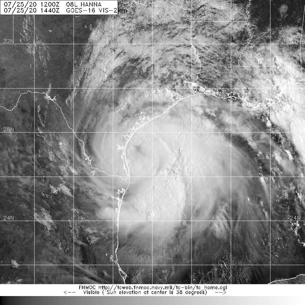
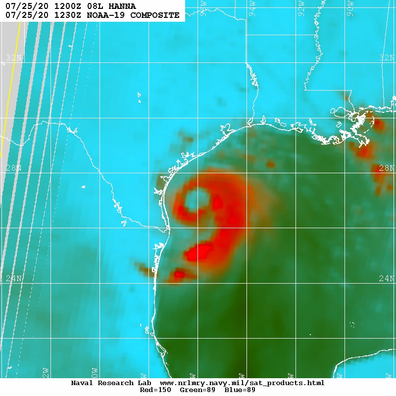
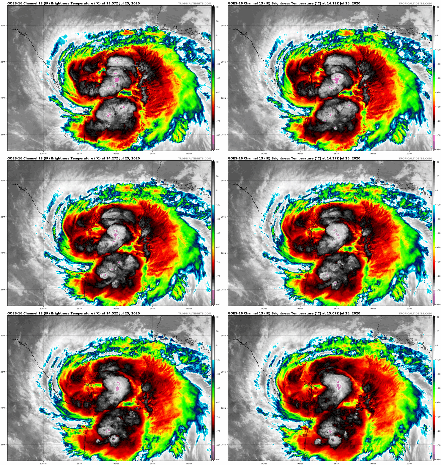
08L目前中心已位於美國德州近岸,NHC升格其為一級颶風
Hanna成為2020年北大西洋第一個颶風.15Z定強70KT,最低氣壓978百帕
000
WTNT43 KNHC 251458
TCDAT3

Hurricane Hanna Discussion Number  11
NWS National Hurricane Center Miami FL       AL082020
1000 AM CDT Sat Jul 25 2020

NOAA Doppler radar data from Corpus Christi and Brownsville, Texas,
along with reconnaissance data from the NOAA Hurricane Hunters
indicate that Hanna has continued to strengthen this morning. A
well-defined but fairly large 30-35-nmi-wide eye has formed and
recent dropsonde data from the eye indicate that the central
pressure has dropped to 978 mb. The aircraft measured a peak 700-mb
flight-level wind speed of 77 kt, which equates to about 69 kt at
the surface. During the past hour, Doppler velocities have sharply
increased with numerous patches of 85-90 kt between 7000-8000 ft
common in the northern eyewall. Although these values would
typically correspond to surface winds of about 75 kt, the Doppler
velocity are occurring in low reflectivity regions of 25-30 dBZ, so
the full effect of those winds are likely not reaching the surface.
This could be why the highest SFMR surface wind observed by the
aircraft was only 63 kt. The initial intensity has been increased to
70 kt, which is a blend of the aircraft flight-level, radar, and
SFMR surface wind speed estimates.

The center position is a tad north of the recon fixes due to some
southward tilt of the eye caused by northerly shear. This has
resulted in a slower westward motion of 270/06 kt. The ridge to the
north of the hurricane has been slowly building westward and
southwestward based on upper-air data over the past 24 hours. This
slow ridging pattern is expected to continue for the next 48 hours,
resulting in  Hanna gradually turning toward the west-southwest by
late this afternoon or evening, with landfall occurring in about 12
h along south Texas coast. After landfall, Hanna should  continue
its west-southwestward motion until dissipation over the mountainous
terrain of northeastern Mexico in 48-60 h. The new NHC track
forecast is similar to the previous advisory track, and lies close
to the tightly packed consensus model guidance.

Although the deep-layer vertical wind shear is expected to remain
out of the north-northwest to north at about 20 kt, the relatively
large and stable eye, along with the expected convective vigor of
the hurricane, could result in a little more strengthening just
before landfall occurs. After landfall, rapid weakening of the wind
field is expected. However, the weakening peak winds will have no
negative effect on the likelihood for heavy rainfall or the
possibility of isolated tornadoes developing.


Key Messages

1. Life-threatening storm surge is occurring along portions of the
Texas coast from Port Mansfield to Sargent, where a Storm Surge
Warning is in effect. Residents in these locations should follow
advice given by local emergency officials.

2. Hurricane conditions are expected along the Texas coast from Port
Mansfield to Mesquite Bay, where a Hurricane Warning is in effect.  
Tropical storm conditions are expected to first reach the coast
within the warning area this morning.

3. Hanna is expected to produce heavy rains across portions of
southern Texas and northeastern Mexico.  These rains could result in
life-threatening flash flooding and isolated minor to moderate river
flooding.


FORECAST POSITIONS AND MAX WINDS

INIT  25/1500Z 27.1N  96.3W   70 KT  80 MPH
12H  26/0000Z 26.9N  97.6W   70 KT  80 MPH...INLAND
24H  26/1200Z 26.4N  99.1W   45 KT  50 MPH...INLAND
36H  27/0000Z 25.9N 100.6W   25 KT  30 MPH...INLAND
48H  27/1200Z 25.3N 102.1W   15 KT  15 MPH...POST-TROP/REMNT LOW
60H  28/0000Z...DISSIPATED

$$
Forecaster Stewart
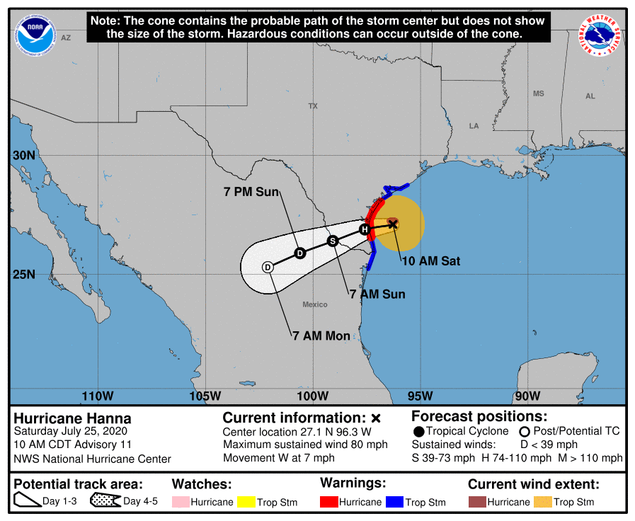
091152_5day_cone_with_line_and_wind.png 20200725.1440.goes-16.vis.2km.08L.HANNA.65kts.982mb.27.1N.96W.pc.jpg
20200725.1230.noaa19.x.color_89_150.08LHANNA.65kts-982mb-271N-960W.096pc.jpg goes16_ir_08L_202007251357.gif

回復

使用道具 舉報

簽到天數: 1650 天

[LV.Master]伴壇終老

老農民版夜神月|2020-7-26 09:00 | 顯示全部樓層
Hanna中心已於稍早進入德州陸地,NHC認定登陸前強度達C1上限80KT,中心最低氣壓973百帕
WTNT63 KNHC 252157
TCUAT3

Hurricane Hanna Tropical Cyclone Update
NWS National Hurricane Center Miami FL       AL082020
500 PM CDT Sat Jul 25 2020

...5 PM CDT POSITION UPDATE...
...HANNA MAKES LANDFALL ON PADRE ISLAND TEXAS...

The eye of Hurricane Hanna made landfall on Padre Island, Texas, at
500 PM CDT (2200 UTC) about 15 miles (20 km) north of Port
Mansfield, Texas, with maximum sustained winds of 90 mph (150 km/h).

A TCOON observing station at Ricon del San Juan, Texas, recently
reported a sustained wind of 60 mph (96 km/h) and a gust to 74 mph
(119 km/h).

NOAA buoy 42020 recently reported a sustained wind of 60 mph (96
km/h) a gust to 69 mph (111 km/h) at a height of 12 ft (3.7 m).


SUMMARY OF 500 PM CDT...2200 UTC...INFORMATION
----------------------------------------------
LOCATION...26.8N 97.4W
ABOUT 15 MI...20 KM N OF PORT MANSFIELD TEXAS
ABOUT 70 MI...110 KM S OF CORPUS CHRISTI TEXAS
MAXIMUM SUSTAINED WINDS...90 MPH...150 KM/H
PRESENT MOVEMENT...WSW OR 255 DEGREES AT 8 MPH...13 KM/H
MINIMUM CENTRAL PRESSURE...973 MB...28.74 INCHES

$$
Forecaster Cangialosi/Brennan
WTNT63 KNHC 252318
TCUAT3

Hurricane Hanna Tropical Cyclone Update
NWS National Hurricane Center Miami FL       AL082020
615 PM CDT Sat Jul 25 2020

...HANNA MAKES A SECOND LANDFALL IN KENEDY COUNTY TEXAS...

Hanna has made a second landfall at 615 PM CDT (2315 UTC) in
eastern Kenedy County, Texas, about 15 miles (25 km) north-northwest
of Port Mansfield, Texas with maximum sustained winds of 90 mph (150
km/h).

A TCOON observing station at Baffin Bay, Texas, recently reported a
sustained wind of 63 mph (101 km/h) and a gust to 76 mph (122 km/h)
in the northern eyewall of Hanna.  

A TCOON observing site at Laguna Madre South, Texas, recently
measured a sustained wind of 51 mph (82 km/h) and a gust to 60 mph
(97 km/h) in the southern eyewall.

Another TCOON observing site at Laguna Madre North, Texas, currently
in the eye of Hanna, recently reported a minimum pressure of 976 mb.


SUMMARY OF 615 PM CDT...2315 UTC...INFORMATION
----------------------------------------------
LOCATION...26.8N 97.5W
ABOUT 15 MI...25 KM NNW OF PORT MANSFIELD TEXAS
ABOUT 70 MI...110 KM S OF CORPUS CHRISTI TEXAS
MAXIMUM SUSTAINED WINDS...90 MPH...150 KM/H
PRESENT MOVEMENT...WSW OR 255 DEGREES AT 8 MPH...13 KM/H
MINIMUM CENTRAL PRESSURE...973 MB...28.74 INCHES

$$
Forecaster Cangialosi/Brennan

goes16_ir_08L_202007252037.gif goes16_vis-swir_08L_202007252037.gif
20200725.2333.f18.composite.08L.HANNA.75kts.973mb.27N.96.8W.050pc.jpg 20200726.0000.goes-16.vis.2km.08L.HANNA.70kts.976mb.26.7N.97.6W.pc.jpg
回復

使用道具 舉報

快速回覆
您需要登錄後才可以回帖 登錄 | 立即加入

本版積分規則

本平台僅供學術討論之用,預報應以氣象局為準

威普網站虛擬主機贊助公司

臺灣第一個天氣類型社群平台 即時天氣資訊、精準颱風動態

線上客服
FB傳送訊息
廣告行銷
精準行銷 物超所值
官方粉專
發佈 快速回復 返回頂部 返回列表