開啟輔助訪問
 找回密碼
 立即加入

06L.Fay 結構鬆散

簽到天數: 601 天

[LV.9]以壇為家II

2020-7-6 08:13 | 顯示全部樓層
本帖最後由 霧峰追風者 於 2020-7-10 07:57 編輯

  基本資料  
編號    :98 L
擾動編號日期:2020 07 06 02
撤編日期  :2020 07 00 00
98L.INVEST.25kts.1013mb.28.8N.88.1W

20200705.2330.goes17.x.vis1km_high.98LINVEST.25kts-1013mb-288N-881W.100pc.jpg

評分

參與人數 1水氣能量 +10 +1 收起 理由
ben811018 + 10 + 1

查看全部評分

回復

使用道具 舉報

簽到天數: 601 天

[LV.9]以壇為家II

霧峰追風者|2020-7-6 08:17 | 顯示全部樓層
NHC 展望20%。
1. A small low pressure system is located over the northern Gulf of
Mexico about 100 miles south-southwest of Panama City, Florida.
While the low currently has limited thunderstorm activity, some
development is still possible before it moves inland early Monday.
This system is expected to evolve into a larger low pressure system
and move northeastward, possibly emerging offshore of the Carolinas
later this week where environmental conditions are expected to be
more conducive for development.
* Formation chance through 48 hours...low...20 percent.
* Formation chance through 5 days...medium...40 percent.
two_atl_2d1.png
回復

使用道具 舉報

簽到天數: 1650 天

[LV.Master]伴壇終老

老農民版夜神月|2020-7-9 02:18 | 顯示全部樓層
發布TCFA,將沿美國東岸北上
SUBJ/TROPICAL CYCLONE FORMATION ALERT//
WTNT21 KNGU 081300
RMKS/
1. FORMATION OF A TROPICAL OR SUBTROPICAL CYCLONE IS POSSIBLE WITHIN
100 NM EITHER SIDE OF A LINE FROM 33.3N 79.4W TO 36.0N 75.4W
WITHIN THE NEXT 24 HOURS. AVAILABLE DATA DOES NOT JUSTIFY
ISSUANCE OF NUMBERED TROPICAL CYCLONE WARNINGS AT THIS TIME.
WINDS IN THE AREA ARE ESTIMATED TO BE 20 TO 25 KNOTS. METSAT
IMAGERY AT 081200Z INDICATES THAT A CIRCULATION CENTER IS LOCATED
NEAR 33.3N 79.4W. THE SYSTEM IS MOVING EASTWARD AT 09 KNOTS.
2. A LARGE AREA OF DISORGANIZED SHOWERS AND THUNDERSTORMS OVER
THE NORTH CAROLINA OFFSHORE WATERS IS ASSOCIATED WITH AN
ELONGATED AREA OF LOW PRESSURE LOCATED NEAR THE COAST OF
NORTHEASTERN SOUTH CAROLINA. THE LOW IS FORECAST TO MOVE
NORTHEASTWARD NEAR THE NORTH CAROLINA OUTER BANKS ON THURSDAY.
ENVIRONMENTAL CONDITIONS ARE EXPECTED TO BE FAVORABLE FOR
DEVELOPMENT AND A TROPICAL OR SUBTROPICAL CYCLONE IS LIKELY TO
FORM DURING THE NEXT 24 HOURS.
3. THIS ALERT WILL BE REISSUED, UPGRADED TO WARNING OR CANCELLED
BY 091300Z.
//
222520ziwt1u9z31cnszza.gif two_atl_2d1.png
98L_intensity_latest.png 98L_gefs_latest.png
回復

使用道具 舉報

簽到天數: 1650 天

[LV.Master]伴壇終老

老農民版夜神月|2020-7-10 04:49 | 顯示全部樓層
本帖最後由 老農民版夜神月 於 2020-7-10 05:15 編輯

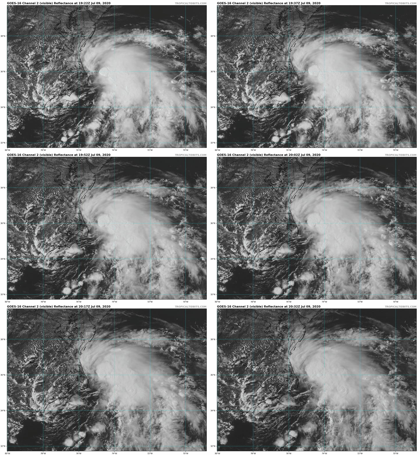
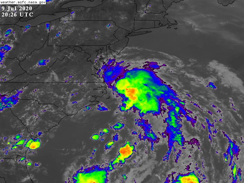
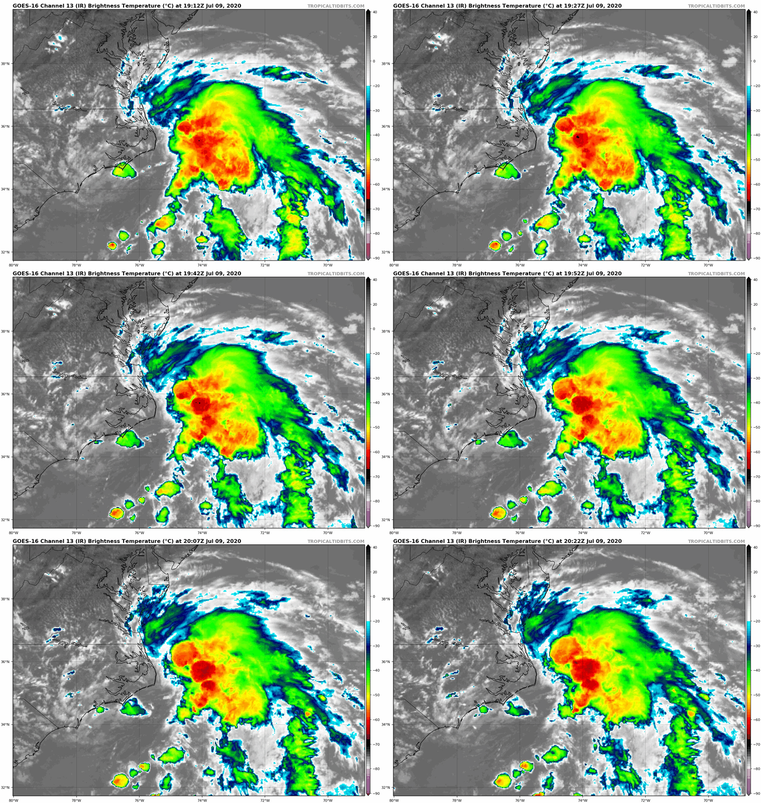
NHC09/21Z報直接升格98L為TS,命名Fay,定強40KT
Special Message from NHC        Issued 9 Jul 2020 20:17 UTC   

NHC will initiate advisories on Tropical Storm Fay, located just east of North Carolina, at 5 pm EDT.
AL, 06, 2020070918, , BEST, 0, 354N, 749W, 40, 1005, TS
000
WTNT41 KNHC 092057
TCDAT1

Tropical Storm Fay Discussion Number   1
NWS National Hurricane Center Miami FL       AL062020
500 PM EDT Thu Jul 09 2020

Satellite and radar imagery, along with surface observations, have
shown that the area of the low pressure near the coast of North
Carolina reformed closer to the deep convection east of the Outer
Banks today.  An Air Force Reserve reconnaissance aircraft
investigating the disturbance this afternoon confirmed that the
center is located near the edge of the primary convective mass, and
that the system is producing an area of 35-40 kt winds to the east
and southeast of the center. Based on these observations, the
system is classified as a tropical storm with an initial intensity
of 40 kt.

Fay is located over the warm waters of the Gulf Stream and within an
area of light to moderate westerly shear.  These environmental
conditions could allow for slight strengthening tonight and Friday.  
After that time, the circulation is forecast to interact with the
mid-Atlantic coast and will be passing over cooler waters north of
the Gulf Stream, likely limiting any further intensification.  Fay
should weakening quickly once it moves inland Friday night or
Saturday.

Since a new center has recently formed, the initial motion is a
highly uncertain 360/6 kt. Fay is expected to move generally
northward between a high pressure ridge over the western Atlantic
and an approaching mid-latitude trough.  The 12Z dynamical model
guidance has come into much better agreement on a track very close
to the U.S. mid-Atlantic coast. With the recent center
reformation to the northeast, the tracker guidance from the
dynamical models shows a track farther offshore than the model
fields imply.  As a result, the NHC track lies along the left side
of the guidance envelope but it is not as far west as what is
indicated in the model fields.

The NHC track and intensity forecast has required the issuance of a
Tropical Storm Warning for a portion of the U.S. coast from the  
mid-Atlantic states to southern New England.

Key Messages:

1. Fay is expected to produce 3 to 5 inches of rain with isolated
totals of 8 inches along and near the track across the mid-Atlantic
states into southeast New York and southern New England. These rains
may result in flash flooding where the heaviest amounts occur.
Widespread river flooding is not expected at this time.

2. Tropical storm conditionsare expected along portions of the
mid-Atlantic and northeast coast Friday and Friday night, and a
Tropical Storm Warning has been issued for the coasts of New Jersey,
New York and Connecticut, including Long Island.

FORECAST POSITIONS AND MAX WINDS

INIT  09/2100Z 35.5N  74.9W   40 KT  45 MPH
12H  10/0600Z 37.1N  74.7W   45 KT  50 MPH
24H  10/1800Z 39.0N  74.3W   45 KT  50 MPH
36H  11/0600Z 41.6N  73.6W   35 KT  40 MPH...INLAND
48H  11/1800Z 45.3N  72.4W   25 KT  30 MPH...INLAND
60H  12/0600Z 49.1N  70.3W   20 KT  25 MPH...POST-TROP/EXTRATROP
72H  12/1800Z...DISSIPATED

$$
Forecaster Brown
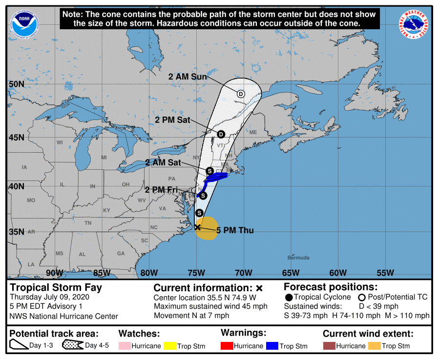
205827_5day_cone_no_line_and_wind.png goes16_vis_98L_202007091922.gif
GOES20262020191gTORXr.jpg goes16_ir_98L_202007091912.gif
回復

使用道具 舉報

簽到天數: 1650 天

[LV.Master]伴壇終老

老農民版夜神月|2020-7-11 12:20 | 顯示全部樓層
06L.Fay環流已位於美國陸地上,即將成為後熱帶氣旋
000
WTNT41 KNHC 110234
TCDAT1

Tropical Storm Fay Discussion Number   7
NWS National Hurricane Center Miami FL       AL062020
1100 PM EDT Fri Jul 10 2020

Satellite and radar data indicate that Fay is no longer generating
organized deep convection as the center moves into northern New
Jersey.  A combination of radar, aircraft, buoy, and ship data show
that 30-35 kt winds are occurring over the water south of central
and western long Island, and based on this the initial intensity is
reduced to 35 kt.  The central pressure of 1001 mb is based on
surface observations.

Barring the return of convection, Fay should continue to weaken and
become post-tropical on Saturday.  After that, the system is
expected to dissipate on Sunday as it merges with a frontal system
over southeastern Canada.  The new intensity forecast has only
minor tweaks from the previous forecast.

The initial motion is now northward or 005 degrees at 15 kt.  The
track forecast philosophy is unchanged, as Fay will be steered
generally northward and north-northeastward until dissipation
between a mid-level ridge over the western Atlantic and an
approaching shortwave trough moving across the Great Lakes.  The
storm is moving a little to the left of the previous forecast, so
the new forecast is nudged to the left due mainly to the initial
position and motion.  The new forecast lies close to the consensus
models.

Users should not place too much emphasis on the exact track of the
center of Fay, as the heaviest rain and strongest winds are now
occurring well away from the center.

Key Messages:

1. Heavy rainfall from eastern Pennsylvania, northeast New Jersey
and across southeast New York, into portions of New England may
result in flash flooding and urban flooding in areas with poor
drainage.  Isolated minor flooding is possible; however, widespread
river flooding is not expected.

2. Tropical storm conditions are expected for several more hours
over portions of coastal New York and Connecticut, including most
of Long Island.


FORECAST POSITIONS AND MAX WINDS

INIT  11/0300Z 41.0N  74.2W   35 KT  40 MPH...INLAND
12H  11/1200Z 43.6N  73.4W   30 KT  35 MPH...POST-TROP/INLAND
24H  12/0000Z 47.5N  71.5W   25 KT  30 MPH...POST-TROP/INLAND
36H  12/1200Z 51.1N  68.9W   25 KT  30 MPH...POST-TROP/INLAND
48H  13/0000Z...DISSIPATED

$$
Forecaster Beven

recon_AF303-0406A-FAY.png 023545_5day_cone_no_line_and_wind.png
GOES04062020193HW64Ww.jpg goes16_truecolor_06L_202007110257.gif
回復

使用道具 舉報

快速回覆
您需要登錄後才可以回帖 登錄 | 立即加入

本版積分規則

霧峰追風者

    主題

    帖子

    221萬

    積分

    16級[四級颶風]

    Rank: 16Rank: 16Rank: 16Rank: 16

16級[四級颶風]

發訊息

本平台僅供學術討論之用,預報應以氣象局為準

威普網站虛擬主機贊助公司

臺灣第一個天氣類型社群平台 即時天氣資訊、精準颱風動態

線上客服
FB傳送訊息
廣告行銷
精準行銷 物超所值
官方粉專
發佈 快速回復 返回頂部 返回列表