開啟輔助訪問
 找回密碼
 立即加入

05L.Edouard 轉化為溫帶氣旋

簽到天數: 1650 天

[LV.Master]伴壇終老

2020-7-4 07:55 | 顯示全部樓層
本帖最後由 老農民版夜神月 於 2020-7-7 11:28 編輯

  基本資料  
編號    :05 L
擾動編號日期:2020 07 04 06
撤編日期  :2020 07 00 00
97L INVEST 200704 0000 30.0N 73.0W ATL 25 1010

073519ui81z6vi99roffgz.jpg

  NHC:20%
1. Showers and thunderstorms have persisted during the past several
hours in association with a small low pressure system located about
midway between Florida and Bermuda. Some gradual development of
this system is possible during the next day or two while the low
moves generally east-northeastward.  By Sunday night, however,
environmental conditions are expected to become unfavorable for
significant development to occur.
* Formation chance through 48 hours...low...10 percent.
* Formation chance through 5 days...low...10 percent.

two_atl_2d0.png two_atl_2d1 (1).png
two_atl_5d1 (1).png

評分

參與人數 1水氣能量 +15 +1 收起 理由
king111807 + 15 + 1 熱帶擾動首帖

查看全部評分

回復

使用道具 舉報

簽到天數: 1650 天

[LV.Master]伴壇終老

老農民版夜神月|2020-7-4 19:44 | 顯示全部樓層
FWC-N04/0900Z發布TCFA
SUBJ/TROPICAL CYCLONE FORMATION ALERT//
WTNT21 KNGU 040900
RMKS/1. FORMATION OF A SIGNIFICANT TROPICAL CYCLONE IS POSSIBLE
WITHIN 100 NM EITHER SIDE OF A LINE FROM 30.5N 71.6W TO 33.0N 64.5W
WITHIN THE NEXT 24 HOURS. AVAILABLE DATA DOES NOT JUSTIFY
ISSUANCE OF NUMBERED TROPICAL CYCLONE WARNINGS AT THIS TIME.
WINDS IN THE AREA ARE ESTIMATED TO BE 25 TO 30 KNOTS. METSAT
IMAGERY AT 040600Z INDICATES THAT A CIRCULATION CENTER IS LOCATED
NEAR 30.5N 71.3W. THE SYSTEM IS MOVING EAST-NORTHEASTWARD AT 15
KNOTS.
2.THE SURFACE CIRCULATION ASSOCIATED WITH A COMPACT LOW PRESSURE
SYSTEM LOCATED ABOUT 400 MILES WEST-SOUTHWEST OF BERMUDA HAS
BECOME BETTER DEFINED. SHOWERS AND THUNDERSTORMS ASSOCIATED WITH
THE SYSTEM ARE PRODUCING WINDS OF 30 KT MAINLY SOUTHEAST OF THE
SURFACE CENTER. IF CONVECTIVE ACTIVITY PERSISTS A TROPICAL
DEPRESSION COULD FORM TODAY OR TONIGHT WHILE THE SYSTEM MOVES
EAST-NORTHEASTWARD AT ABOUT 10 TO 12 KT.
3. THIS ALERT WILL BE REISSUED, UPGRADED TO WARNING OR CANCELLED
BY 050900Z.//
未命名.png two_atl_2d1.png
goes16_vis-swir_97L_202007040937_lat30.5-lon288.7.jpg GOES11312020186wEBN7X.jpg


回復

使用道具 舉報

簽到天數: 1650 天

[LV.Master]伴壇終老

老農民版夜神月|2020-7-4 23:48 | 顯示全部樓層
NHC03/15Z升格其為TD05L,或將命名
WTNT45 KNHC 041451
TCDAT5

Tropical Depression Five Discussion Number   1
NWS National Hurricane Center Miami FL       AL052020
1100 AM AST Sat Jul 04 2020

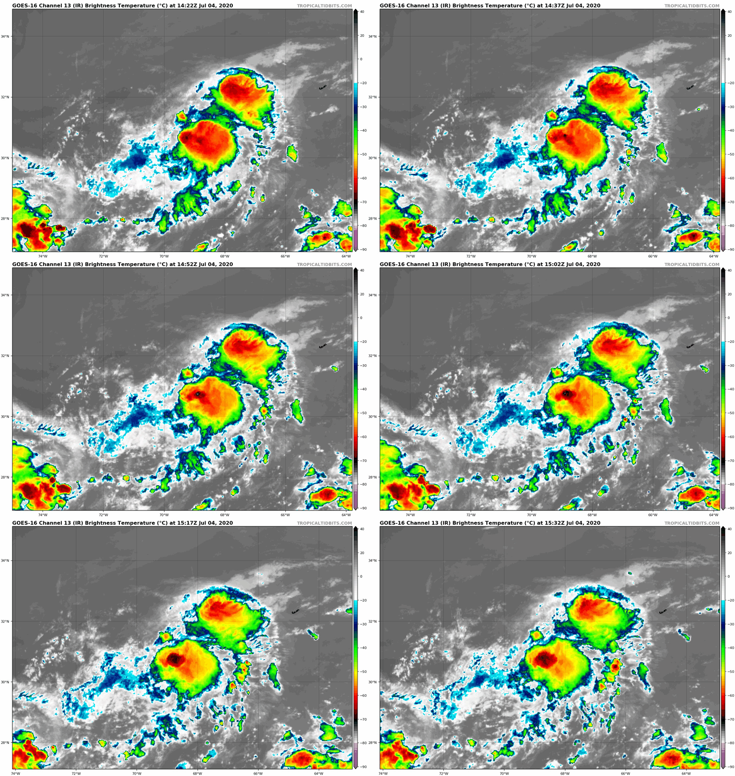
Late yesterday, a small low pressure system developed near the end
of a boundary over the western Atlantic. The low persisted overnight
while producing convection that has shown increasing signs of
organization. Although the low's center has recently become
obscured, earlier one-minute visible imagery confirmed that it is
well-defined. The system therefore meets the necessary criteria to
be designated as a tropical cyclone. A TAFB Dvorak classification of
2.0 is the basis for the 30 kt initial intensity.

The depression is moving quickly toward the east-northeast, caught
in the flow between a mid-level ridge to its south and a a trough
to its north. This steering pattern is expected to be fairly stable
for the next day or so, and the guidance is in good agreement that
the cyclone will continue on its current general heading with an
increase in forward speed during the next couple of days. The NHC
track forecast closely follows the TVCN and HCCA consensus aids.

The depression has a sheared appearance, with no convection
northwest of its low-level center. A combination of strong
upper-level westerly winds and dry mid-level air to the northwest
are likely the cause of this, and it is unlikely that the cyclone
will get much better organized during the next day or two. That
said, some minimal strengthening is possible, even if only due to
the expected increase of the cyclone's forward speed. The NHC
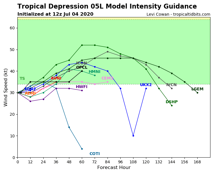
intensity forecast is based on a consensus of the HWRF, HMON, and
GFS models. It is worth noting that the statistical guidance
indicates more strengthening is possible, but this is not currently
supported by any dynamical models. There is less agreement on the
system's future beyond the weekend. It could open into a trough and
dissipate or persist long enough to undergo extratropical
transition. Since this is the first advisory, the official forecast
is somewhat conservative and maintains the system as a closed low
for 60 h, but it could certainly dissipate sooner than that.


FORECAST POSITIONS AND MAX WINDS

INIT  04/1500Z 31.1N  68.7W   30 KT  35 MPH
12H  05/0000Z 32.1N  66.5W   35 KT  40 MPH
24H  05/1200Z 34.0N  63.5W   35 KT  40 MPH
36H  06/0000Z 36.4N  59.4W   35 KT  40 MPH
48H  06/1200Z 39.2N  52.7W   35 KT  40 MPH
60H  07/0000Z 41.7N  46.8W   40 KT  45 MPH...POST-TROP/EXTRATROP
72H  07/1200Z...DISSIPATED

$$
Forecaster Zelinsky
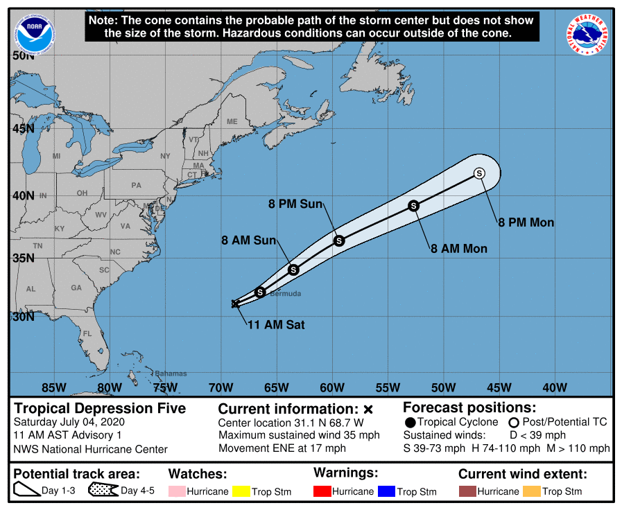
145229_5day_cone_with_line_and_wind.png 05L_intensity_latest.png
goes16_ir_05L_202007041422.gif


回復

使用道具 舉報

簽到天數: 1650 天

[LV.Master]伴壇終老

老農民版夜神月|2020-7-6 12:32 | 顯示全部樓層
NHC06/03Z升格TS,命名Edouard
773
WTNT45 KNHC 060238
TCDAT5

Tropical Storm Edouard Discussion Number   7
NWS National Hurricane Center Miami FL       AL052020
1100 PM AST Sun Jul 05 2020

Satellite images indicate that the cyclone has become better
organized during the past several hours, with a large convective
burst causing a better-defined low-level circulation.  While the
center is now becoming exposed due to southwesterly shear, the
maximum winds have almost certainly increased from earlier, so the
initial wind speed is set to 35 kt. A recent partial ASCAT pass of
at least 30 kt outside the RMW also supports the upgrade to a
tropical storm, and the CIMSS satellite consensus (SATCON) is even
higher than the analyzed intensity.  

Edouard is moving northeastward even faster than before, or 055/30
kt. Model guidance is in fairly good agreement on a quick
northeastward or east-northeastward motion for the next couple of
days before the system degenerates into a trough.  Extratropical
transition is anticipated by 24 hours due to forcing from a
middle-latitude trough and a frontal boundary.  Some minor
strengthening of Edouard due to the transition process is possible
over the next day or so before the global models show a gradual
weakening.  The track forecast has been adjusted a bit faster to
account for the latest guidance and initial forward speed, and the
intensity forecast has also been nudged upward to account for the
current wind speed.

Edouard is the earliest known 5th named storm on record for the
Atlantic basin in the satellite era (1966-present), breaking the
record formerly held by Emily on July 12, 2005.


FORECAST POSITIONS AND MAX WINDS

INIT  06/0300Z 37.2N  56.9W   35 KT  40 MPH
12H  06/1200Z 39.6N  51.7W   40 KT  45 MPH
24H  07/0000Z 42.9N  44.6W   40 KT  45 MPH...POST-TROP/EXTRATROP
36H  07/1200Z 46.5N  37.3W   35 KT  40 MPH...POST-TROP/EXTRATROP
48H  08/0000Z 50.0N  29.0W   30 KT  35 MPH...POST-TROP/EXTRATROP
60H  08/1200Z...DISSIPATED

$$
Forecaster Blake
023909_5day_cone_no_line_and_wind.png 05L_gefs_latest.png
goes16_ir_05L_202007060155.gif goes16_vis-swir_05L_202007060155.gif
回復

使用道具 舉報

簽到天數: 1650 天

[LV.Master]伴壇終老

老農民版夜神月|2020-7-7 09:04 | 顯示全部樓層
NHC06/21Z報判定已轉化為溫帶氣旋
000
WTNT45 KNHC 062033
TCDAT5

Post-Tropical Cyclone Edouard Discussion Number  10
NWS National Hurricane Center Miami FL       AL052020
500 PM AST Mon Jul 06 2020

Although Edouard continues to produce some deep convection, recent
satellite imagery and scatterometer data indicate that the center of
the cyclone has merged with a frontal boundary. Therefore, the
system is now classified as extratropical and this is the last
advisory. The scatterometer data showed max winds of 35-40 kt, so
the initial intensity remains 40 kt.  The 35 kt wind radii were
also increased in the southeast quadrant based on the scatterometer
data.

The post-tropical cyclone is forecast to continue moving quickly
northeastward for the next day or so until it is absorbed into a
larger frontal zone over the north Atlantic late Tuesday or early
Wednesday. The NHC track and intensity forecast is close to the
global model consensus, and all of those models are in good
agreement for the next 24 h.

This is the last NHC advisory on Edouard. Additional information on
this system can be found in High Seas Forecasts issued by the
National Weather Service, under AWIPS header NFDHSFAT1, WMO header
FZNT01 KWBC, and online at ocean.weather.gov/shtml/NFDHSFAT1.php

FORECAST POSITIONS AND MAX WINDS

INIT  06/2100Z 42.7N  46.0W   40 KT  45 MPH...POST-TROP/EXTRATROP
12H  07/0600Z 45.1N  40.7W   40 KT  45 MPH...POST-TROP/EXTRATROP
24H  07/1800Z 48.5N  33.2W   40 KT  45 MPH...POST-TROP/EXTRATROP
36H  08/0600Z...DISSIPATED

$$
Forecaster Zelinsky
203614_5day_cone_no_line_and_wind.png 063004das4jjswabtum6bm.gif
GOES00502020189acPglT.jpg
回復

使用道具 舉報

快速回覆
您需要登錄後才可以回帖 登錄 | 立即加入

本版積分規則

本平台僅供學術討論之用,預報應以氣象局為準

威普網站虛擬主機贊助公司

臺灣第一個天氣類型社群平台 即時天氣資訊、精準颱風動態

線上客服
FB傳送訊息
廣告行銷
精準行銷 物超所值
官方粉專
發佈 快速回復 返回頂部 返回列表