開啟輔助訪問
 找回密碼
 立即加入

14S.Damien 西澳近岸發展 風眼開啟達C2

簽到天數: 1650 天

[LV.Master]伴壇終老

2020-2-4 01:24 | 顯示全部樓層
本帖最後由 老農民版夜神月 於 2020-2-8 21:56 編輯

  基本資料  
編號    :14 S
擾動編號日期:2020 02 04 00
撤編日期  :2020 02 00 00
92S.INVEST.15kts.996mb.16.3S.128.1E

20200203.0708.f15.37h.92S.INVEST.15kts.996mb.16.3S.128.1E.090pc.jpg

評分

參與人數 1水氣能量 +15 +1 收起 理由
king111807 + 15 + 1 熱帶擾動首帖

查看全部評分

回復

使用道具 舉報

簽到天數: 1650 天

[LV.Master]伴壇終老

老農民版夜神月|2020-2-4 15:38 | 顯示全部樓層
本帖最後由 老農民版夜神月 於 2020-2-4 15:41 編輯

BoM預測系統中心離開澳洲陸地後不久,+48H後將升格TC
Headline:
Tropical low expected to move off northwest Kimberley coast tomorrow and develop into a tropical cyclone. Severe tropical cyclone impact possible along the Pilbara coast this weekend.

Areas affected:
Warning zone: None.
Watch zone: None.
Cancelled zones: None.

Details of Tropical Low at 2:00 pm AWST:
Intensity: tropical low, sustained winds near the centre of 20 kilometres per hour with wind gusts to 85 kilometres per hour.
Location: within 75 kilometres of 16.5 degrees South, 126.7 degrees East , 235 kilometres west southwest of Kununurra and 340 kilometres east northeast of Derby .
Movement: west at 15 kilometres per hour .
The low is expected to track to the west and move offshore on Wednesday and develop into a cyclone. The cyclone is then forecast to turn towards the Pilbara coast on Friday and intensify further before reaching the coast on the weekend. At this stage a severe cyclone impact is possible for the Pilbara coast between Exmouth and Port Hedland on the weekend.

#!001_MicrosoftEdge_User_Default_WebNotes_Microsoft-Edge-Web-Notes-Tropical-69700343.jpg IDW60280.png
未命名.png #!001_MicrosoftEdge_User_Default_WebNotes_Microsoft-Edge-Web-Notes-【讨论扰动】9.jpg

回復

使用道具 舉報

簽到天數: 1650 天

[LV.Master]伴壇終老

老農民版夜神月|2020-2-5 00:29 | 顯示全部樓層
JTWC04/1530Z直接將其評級Medium
(2) AN AREA OF CONVECTION (INVEST 92S) HAS PERSISTED NEAR
16.1S 125.8E, APPROXIMATELY 235 NM EAST-NORTHEAST OF BROOME,
AUSTRALIA. ANIMATED ENHANCED INFRARED SATELLITE AND WYNDHAM RADAR
IMAGERY DEPICT FORMATIVE BANDING WRAPPING INTO A DEFINED LOW LEVEL
CIRCULATION CENTER (LLCC) CURRENTLY PLACED OVER LAND. THE IMPROVING
STRUCTURE EVIDENT IN THE ANIMATED LOOPS REFLECTS STEADY
CONSOLIDATION AS INVEST 92S TRACKS GENERALLY WESTWARD TOWARD THE
COAST. SURFACE OBSERVATIONS AT ADELE ISLAND, APPROXIMATELY 153 NM
WEST OF THE LLCC, REVEAL ROBUST (20-25 KNOTS SUSTAINED) WESTERLY
FLOW OVER THE WESTERN PERIPHERY OF THE SYSTEM. AFTER TAU 12, INVEST
92S IS EXPECTED TO DEVELOP RAPIDLY AS IT TRACKS OVER VERY WARM (30-
32C) WATER AND INTO AN AREA OF LOW (10-15 KNOTS) VWS AND IMPROVING
DIFFLUENCE ALOFT. GLOBAL MODELS ARE IN FAIR AGREEMENT ON THE
WESTWARD TRACK OVER THE NEXT 48 HOURS. MAXIMUM SUSTAINED SURFACE
WINDS ARE ESTIMATED AT 20 TO 25 KNOTS. MINIMUM SEA LEVEL PRESSURE IS
ESTIMATED TO BE NEAR 1002 MB. THE POTENTIAL FOR THE DEVELOPMENT OF A
SIGNIFICANT TROPICAL CYCLONE WITHIN THE NEXT 24 HOURS IS MEDIUM.
43176.jpg 92S_gefs_latest.png
43177.jpg
回復

使用道具 舉報

簽到天數: 2141 天

[LV.Master]伴壇終老

周子堯@FB|2020-2-5 13:20 | 顯示全部樓層

92S TCFA 近岸發展

JTWC 03Z發布TCFA。
TPXS11 PGTW 050310

A. TROPICAL DISTURBANCE 92S (NW OF AUSTRALIA)

B. 05/0230Z

C. 16.33S

D. 123.40E

E. FIVE/HMWRI8

F. T1.5/1.5

G. IR/EIR/VIS/MSI

H. REMARKS: 40A/PBO SBC/ANMTN. CNVCTN WRAPS .30 ON LOG10 SPIRAL
YIELDING A DT OF 1.5. MET/PT AGREE. DBO DT.

I. ADDITIONAL POSITIONS: NONE

sh9220.gif
vis_lalo-animated.gif

回復

使用道具 舉報

簽到天數: 1650 天

[LV.Master]伴壇終老

老農民版夜神月|2020-2-6 13:40 | 顯示全部樓層
本帖最後由 老農民版夜神月 於 2020-2-6 15:26 編輯

BoM06/06Z升格澳式C1,命名Damien,預測將達澳式C4,並以巔峰登陸西澳
;JTWC升格Tropical Cyclone 14S,06/03Z首報顛峰上望70KT
TC ADVISORY
DTG: 20200206/0600Z
TCAC: DARWIN
TC: DAMIEN
ADVISORY NR: 2020/2
OBS PSN: 06/0600Z S1654 E11948
CB: WI 100NM OF TC CENTRE TOP FL600
MOV: W 08KT
C: 992HPA
MAX WIND: 40KT
FCST PSN +6HR: 06/1200 S1712 E11900
FCST MAX WIND +6HR: 45KT
FCST PSN +12HR: 06/1800 S1724 E11812
FCST MAX WIND +12HR: 50KT
FCST PSN +18HR: 07/0000 S1736 E11742
FCST MAX WIND +18HR: 55KT
FCST PSN +24HR: 07/0600 S1800 E11718
FCST MAX WIND +24HR: 65KT
RMK: NIL
NXT MSG: 20200206/1300Z
HURRICANE FORCE WIND WARNING

Please be aware, wind gusts can be a further 40 percent stronger than the
averages given here, and maximum waves may be up to twice the height.

SITUATION
At 0600 UTC Tropical Cyclone Damien was centred within 25 nautical miles of
latitude sixteen decimal nine south (16.9S)
longitude one hundred and nineteen decimal eight east (119.8E)
Recent movement : west at 8 knots
Maximum winds : 40 knots
Central pressure: 992 hPa

AREA AFFECTED
Within 90 nautical miles in NE quadrant
and within 90 nautical miles in SE quadrant
and within 80 nautical miles in SW quadrant
and within 60 nautical miles in NW quadrant.

FORECAST
Maximum winds to 40 knots near the centre increasing to 65 knots by 0600 UTC 07
February.

From 0600 UTC 7 February winds above 64 knots within 15 nautical miles of
centre with very high seas.

From 1800 UTC 6 February winds above 48 knots within 30 nautical miles of
centre with very rough to high seas and moderate swell.

Winds above 34 knots within 90 nautical miles in NE quadrant
and within 90 nautical miles in SE quadrant
and within 80 nautical miles in SW quadrant
and within 60 nautical miles in NW quadrant, with rough seas and low to
moderate swell.

Forecast positions
At 1800 UTC 06 February: Within 50 nautical miles of 17.4 south 118.2 east
Central pressure 986 hPa.
Winds to 50 knots near centre.
At 0600 UTC 07 February: Within 70 nautical miles of 18.0 south 117.3 east
Central pressure 972 hPa.
Winds to 65 knots near centre.

REMARKS
All ships in the area please send weather reports every three hours.
Regular weather observing ships use normal channels.
Other ships please use either email to tcwcwa@bom.gov.au or fax to +61892632261
or satellite using SAC1241 through Land Earth Station Burum 312 [or 212 as
appropriate] via Perth.

Next warning will be issued by 1300 UTC 06 February 2020.

#!001_MicrosoftEdge_User_Default_WebNotes_Microsoft-Edge-Web-Notes-Tropical-74245046.jpg IDW60280.png
sh1420.gif 14S_060130sair.jpg
wv0.gif
回復

使用道具 舉報

簽到天數: 1650 天

[LV.Master]伴壇終老

老農民版夜神月|2020-2-7 16:09 | 顯示全部樓層
BoM06Z升格三級強熱帶氣旋(澳式C3),預測巔峰將達90KT
JTWC06Z同時升格C1,預測巔峰85KT

IDW27600
TROPICAL CYCLONE TECHNICAL BULLETIN: AUSTRALIA - WESTERN REGION
Issued by PERTH TROPICAL CYCLONE WARNING CENTRE
at: 0651 UTC 07/02/2020
Name: Severe Tropical Cyclone Damien
Identifier: 05U
Data At: 0600 UTC
Latitude: 18.1S
Longitude: 117.0E
Location Accuracy: within 20 nm [35 km]
Movement Towards: southwest [229 deg]
Speed of Movement: 4 knots [7 km/h]
Maximum 10-Minute Wind: 65 knots [120 km/h]
Maximum 3-Second Wind Gust: 90 knots [165 km/h]
Central Pressure: 972 hPa
Radius of 34-knot winds NE quadrant: 50 nm [95 km]
Radius of 34-knot winds SE quadrant: 70 nm [130 km]
Radius of 34-knot winds SW quadrant: 70 nm [130 km]
Radius of 34-knot winds NW quadrant: 60 nm [110 km]
Radius of 48-knot winds NE quadrant: 30 nm [55 km]
Radius of 48-knot winds SE quadrant: 30 nm [55 km]
Radius of 48-knot winds SW quadrant: 30 nm [55 km]
Radius of 48-knot winds NW quadrant: 30 nm [55 km]
Radius of 64-knot winds:
Radius of Maximum Winds: 15 nm [30 km]
Dvorak Intensity Code: T4.0/4.0/D1.0/24HRS STT:S0.0/6HRS
Pressure of outermost isobar: 1002 hPa
Radius of outermost closed isobar: 140 nm [260 km]
FORECAST DATA
Date/Time    : Location    : Loc. Accuracy: Max Wind   : Central Pressure
[UTC]        : degrees     :      nm  [km]: knots[km/h]: hPa
+06:  07/1200: 18.7S 116.9E:     040 [075]:  075  [140]:  963
+12:  07/1800: 19.4S 116.9E:     055 [100]:  085  [155]:  954
+18:  08/0000: 20.0S 116.9E:     065 [125]:  090  [165]:  950
+24:  08/0600: 20.7S 117.0E:     080 [145]:  090  [165]:  949

+36:  08/1800: 21.9S 117.5E:     100 [185]:  045  [085]:  986
+48:  09/0600: 23.0S 117.7E:     120 [220]:  040  [070]:  990
+60:  09/1800: 24.0S 117.6E:     140 [255]:  035  [065]:  993
+72:  10/0600: 25.4S 117.5E:     155 [290]:  030  [055]:  994
+96:  11/0600: 29.5S 118.4E:     200 [370]:  025  [045]:  998
+120: 12/0600:             :              :            :     
REMARKS:
05U was located using radar imagery. Fix confidence as the cyclone core comes
into radar range.

More of the LLCC has become exposed during daylight hours and intensification
appears to have slowed, however VIS images show a ragged eye trying to form and
conditions remain favourable for further intensificaiton. CIMSS analysed shear
is 9 knots from the ENE at 0000 UTC and is forecast to remain low over the neext
48 hours. Ocean heat content is high along the forecast track. Hence 05U is
expected to continue to develop as it approaches the coast.

ADT CI estimates are between 3.6 and 4.0 [NESDIS/CIMSS] with the difference
explained by the MW contribution on the CIMSS estimate. Until very recently
CIMSS ADT was at 4.5 CI. No SATCON estimates received in the last 6 hours. Final
intensity estimate is set at 65 knots 10-minute.  

The timing of landfall varies from early Saturday to overnight into Sunday
depending upon the steering influences of the ridge to the east and the
weakening upper mid-latitude trough.

Copyright Commonwealth of Australia
==
The next bulletin for this system will be issued by: 07/1330 UTC by Perth TCWC.

IDW60280.png sh1420.gif
vis0.gif bd0.gif
回復

使用道具 舉報

簽到天數: 1650 天

[LV.Master]伴壇終老

老農民版夜神月|2020-2-8 21:53 | 顯示全部樓層
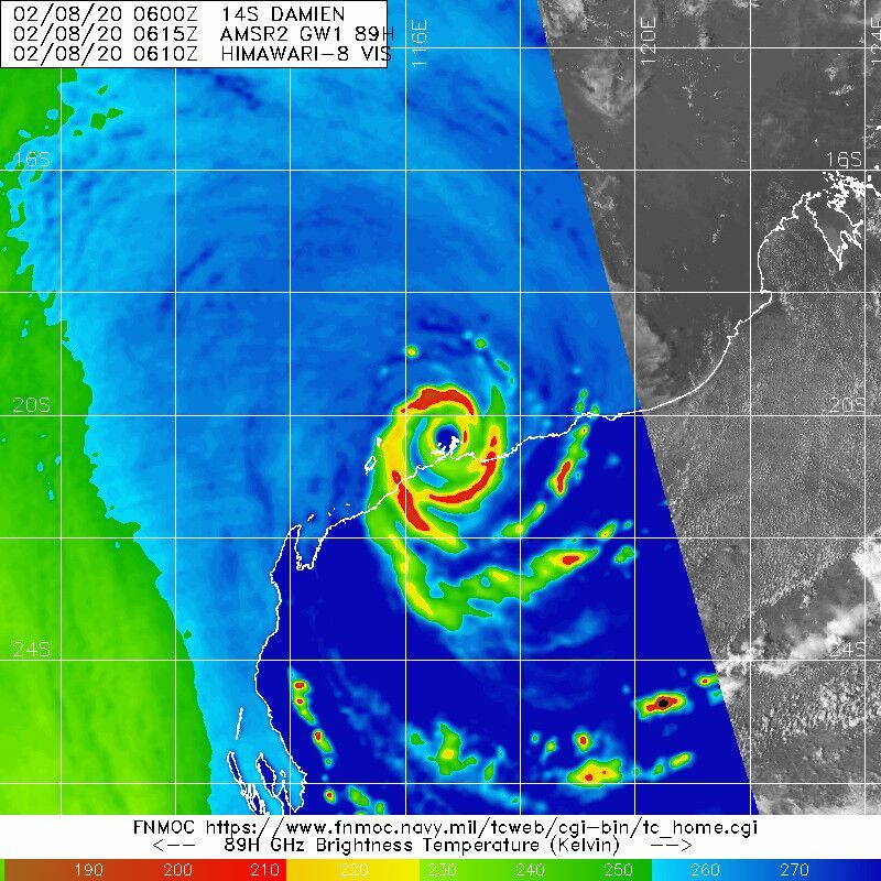
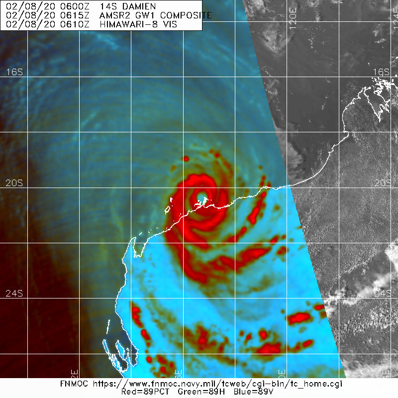
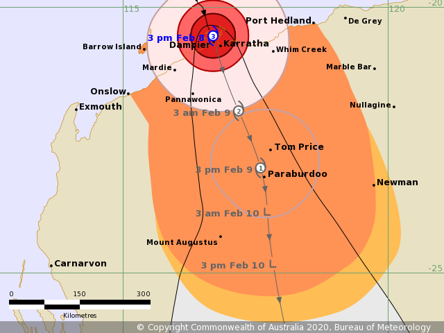
BoM判定Damien16/07Z~08Z左右已登陸丹皮爾附近
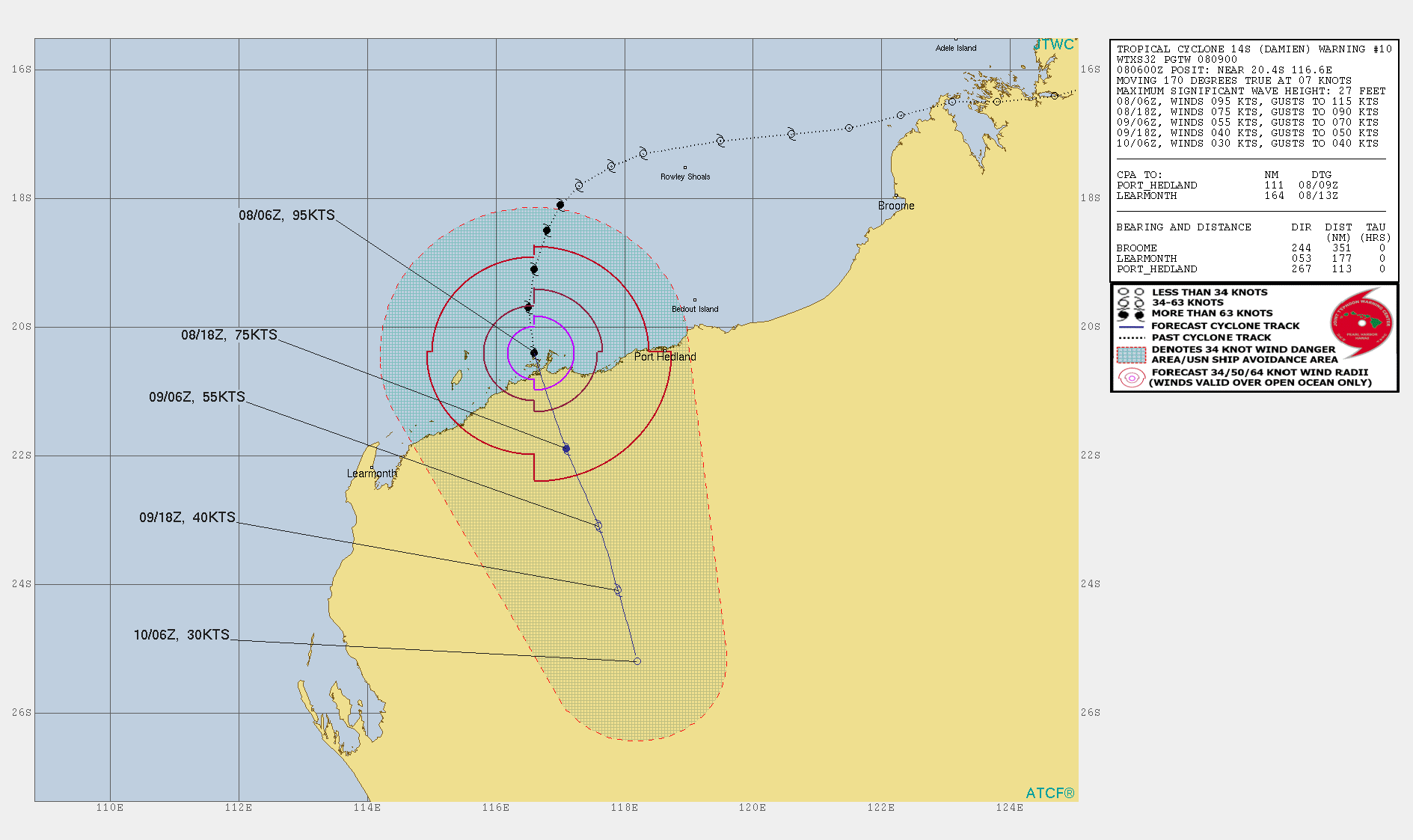
BoM,JTWC均認定顛峰時間於16/06Z.BoM定強為80KT,JTWC則為95KT

Details of Severe Tropical Cyclone Damien at 4:00 pm AWST:
Intensity: category 3, sustained winds near the centre of 150 kilometres
per hour with wind gusts to 205 kilometres per hour.
Location: within 20 kilometres of 20.7 degrees South, 116.7 degrees East ,
15 kilometres west northwest of Karratha and 200 kilometres east northeast
of Onslow .
Movement: south southeast at 16 kilometres per hour .
Severe Tropical Cyclone Damien is crossing the coast near Dampier.
未命名2.png
IDW27600
TROPICAL CYCLONE TECHNICAL BULLETIN: AUSTRALIA - WESTERN REGION
Issued by PERTH TROPICAL CYCLONE WARNING CENTRE
at: 0717 UTC 08/02/2020
Name: Severe Tropical Cyclone Damien
Identifier: 05U
Data At: 0600 UTC
Latitude: 20.4S
Longitude: 116.6E
Location Accuracy: within 10 nm [20 km]
Movement Towards: south southeast [168 deg]
Speed of Movement: 7 knots [13 km/h]
Maximum 10-Minute Wind: 80 knots [150 km/h]
Maximum 3-Second Wind Gust: 110 knots [205 km/h]
Central Pressure: 955 hPa
Radius of 34-knot winds NE quadrant: 80 nm [150 km]
Radius of 34-knot winds SE quadrant: 90 nm [165 km]
Radius of 34-knot winds SW quadrant: 70 nm [130 km]
Radius of 34-knot winds NW quadrant: 65 nm [120 km]
Radius of 48-knot winds NE quadrant: 40 nm [75 km]
Radius of 48-knot winds SE quadrant: 40 nm [75 km]
Radius of 48-knot winds SW quadrant: 40 nm [75 km]
Radius of 48-knot winds NW quadrant: 40 nm [75 km]
Radius of 64-knot winds:
Radius of Maximum Winds: 20 nm [35 km]
Dvorak Intensity Code: T5.0/5.0/D1.0/24HRS STT:0.5/6HRS
Pressure of outermost isobar: 1002 hPa
Radius of outermost closed isobar: 105 nm [195 km]
FORECAST DATA
Date/Time : Location : Loc. Accuracy: Max Wind : Central Pressure
[UTC] : degrees : nm [km]: knots[km/h]: hPa
+06: 08/1200: 21.1S 116.8E: 030 [055]: 075 [140]: 967
+12: 08/1800: 21.8S 117.1E: 040 [075]: 060 [110]: 978
+18: 09/0000: 22.4S 117.4E: 055 [100]: 045 [085]: 985
+24: 09/0600: 22.9S 117.5E: 070 [130]: 040 [075]: 989
+36: 09/1800: 23.7S 117.7E: 090 [165]: 035 [065]: 992
+48: 10/0600: 24.7S 117.8E: 110 [205]: 030 [055]: 994
+60: 10/1800: 26.0S 118.0E: 130 [240]: 025 [045]: 996
+72: 11/0600: : : :
+96: 12/0600: : : :
+120: 13/0600: : : :
REMARKS:
Severe Tropical Cyclone Damien [05U] was located using radar imagery, providing
very good confidence in centre location. Dampier radar has been intermittent,
but the cenre has also been visible on Port Hedland Radar.


Dvorak: Eye Pattern has given fluctuating minimum distances in the surrounding
ring temperature. Recently DT=5.0, which is consistent with the MET. FT/CI is
set at 5.0. ADT has been running higher with CIMSS ADT CI=5.8 [Eye pattern, raw
numbers reaching 6.0] and NESDIS CI=5.6. Winds at Karratha Airport reached 77
knots [10-mintue mean] in the last hour. Offshore sites have been observing mean
winds 60 to 70 knots in the last hour. Final intensity estimate is set at 80
knots 10-minute.


Damien is making landfall now. Although it may develop slightly in the next hour
before crossing, Damien is estimated to be at peak intensity now. Once inland,
Damien should weaken and is forecast to be below tropical cyclone intensity by
late Sunday evening. Gales may persist in southern quadrants into Monday
morning. Very heavy rainfall is forecast and there is potential for a very
dangerous storm tide as the cyclone centre crosses the coast.


Copyright Commonwealth of Australia
==
The next bulletin for this system will be issued by: 08/1330 UTC by Perth TCWC.
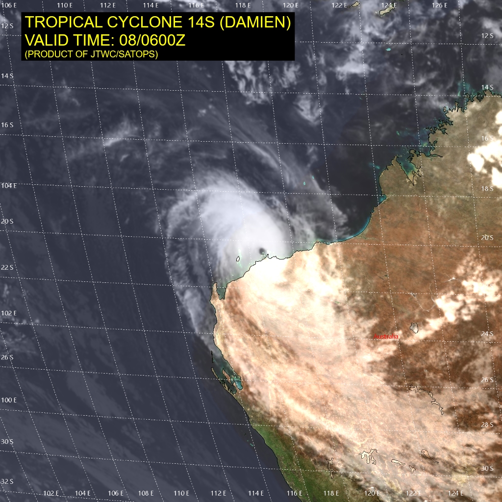
sh1420.gif 14S_080600sair.jpg
未命名1.png 未命名.png
回復

使用道具 舉報

快速回覆
您需要登錄後才可以回帖 登錄 | 立即加入

本版積分規則

本平台僅供學術討論之用,預報應以氣象局為準

威普網站虛擬主機贊助公司

臺灣第一個天氣類型社群平台 即時天氣資訊、精準颱風動態

線上客服
FB傳送訊息
廣告行銷
精準行銷 物超所值
官方粉專
發佈 快速回復 返回頂部 返回列表